HONDA RIDGELINE 2011 1.G Navigation Manual
Manufacturer: HONDA, Model Year: 2011, Model line: RIDGELINE, Model: HONDA RIDGELINE 2011 1.GPages: 151, PDF Size: 4.78 MB
Page 121 of 151
Navigation System121
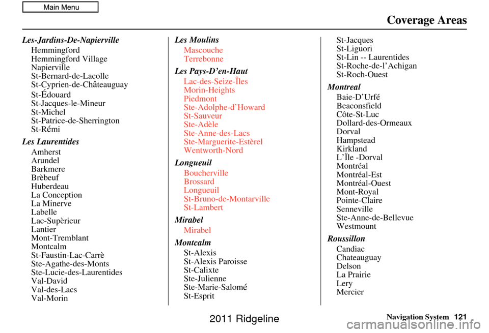
Les-Jardins-De-Napierville
Hemmingford
Hemmingford Village
Napierville
St-Bernard-de-Lacolle
St-Cyprien-de-Ch
âteauguay
St-
Édouard
St-Jacques-le-Mineur
St-Michel
St-Patrice-de-Sherrington
St-R
émi
Les Laurentides Amherst
Arundel
Barkmere
Brèbeuf
Huberdeau
La Conception
La Minerve
Labelle
Lac-Supèrieur
Lantier
Mont-Tremblant
Montcalm
St-Faustin-Lac-Carrè
Ste-Agathe-des-Monts
Ste-Lucie-des-Laurentides
Val-David
Val-des-Lacs
Val-Morin Les Moulins
Mascouche
Terrebonne
Les Pays-D’en-Haut Lac-des-Seize-Îles
Morin-Heights
Piedmont
Ste-Adolphe-d’Howard
St-Sauveur
Ste-Adèle
Ste-Anne-des-Lacs
Ste-Marguerite-Estèrel
Wentworth-Nord
Longueuil Boucherville
Brossard
Longueuil
St-Bruno-de-Montarville
St-Lambert
Mirabel Mirabel
Montcalm St-Alexis
St-Alexis Paroisse
St-Calixte
Ste-Julienne
Ste-Marie-Salom
éSt-Esprit St-Jacques
St-Liguori
St-Lin -- Laurentides
St-Roche-de-l’Achigan
St-Roch-Ouest
Montreal Baie-D’Urfé
Beaconsfield
Côte-St-Luc
Dollard-des-Ormeaux
Dorval
Hampstead
Kirkland
L’Ïle -Dorval
Montréal
Montréal-Est
Montréal-Ouest
Mont-Royal
Pointe-Claire
Senneville
Ste-Anne-de-Bellevue
Westmount
Roussillon Candiac
Chateauguay
Delson
La Prairie
Lery
Mercier
Coverage Areas
2011 Ridgeline
Page 122 of 151
122Navigation System
Coverage Areas
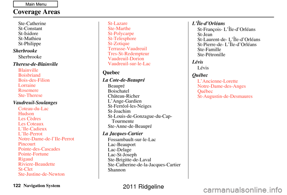
Ste-Catherine
St-Constant
St-Isidore
St-Mathieu
St-Philippe
Sherbrooke Sherbrooke
Therese-de-Blainville Blainville
Boisbriand
Bois-des-Filion
Lorraine
Rosemere
Ste-Therese
Vaudreuil-Soulanges Coteau-du-Lac
Hudson
Les Cèdres
Les Coteaux
L’Ile-Cadieux
L’Ile-Perrot
Notre-Dame-de-l’Ile-Perrot
Pincourt
Pointe-des-Cascades
Pointe-Fortune
Rigaud
Riviere-Beaudette
St-Clet
Ste-Justine-de-Newton St-Lazare
Ste-Marthe
St-Polycarpe
St-Telesphore
St-Zotique
Terrasse-Vaudreuil
Tres-St-Redempteur
Vaudreuil-Dorion
Vaudreuil-sur-le-Lac
Quebec
La Cote-de-Beaupré
Beaupré
Boischatel
Château-Richer
L’Ange-Gardien
St-Ferréol-les-Neiges
St-Joachim
St-Louis-de-Gonzague-du-Cap-Tourmente
Ste-Anne-de-Beaupré
La Jacques-Cartier Fossambault-sur-le-Lac
Lac-Beauport
Lac-Delage
Lac-St-Joseph
Ste-Brigitte-de-Laval
Ste-Catherine-de-la-Jacques-Cartier
Shannon L’Île-d’Orléans
St-François- L’Île-d’Orléans
St-Jean
St-Laurent-de- L’Île-d’Orléans
St-Pierre-de- L’Île-d’Orléans
Ste-Famille
Ste-Pétronille
Lévis Lévis
Québec L’Ancienne-Lorette
Notre-Dame-des-Anges
Québec
St-Augustin-de-Desmaures
2011 Ridgeline
Page 123 of 151
Navigation System123
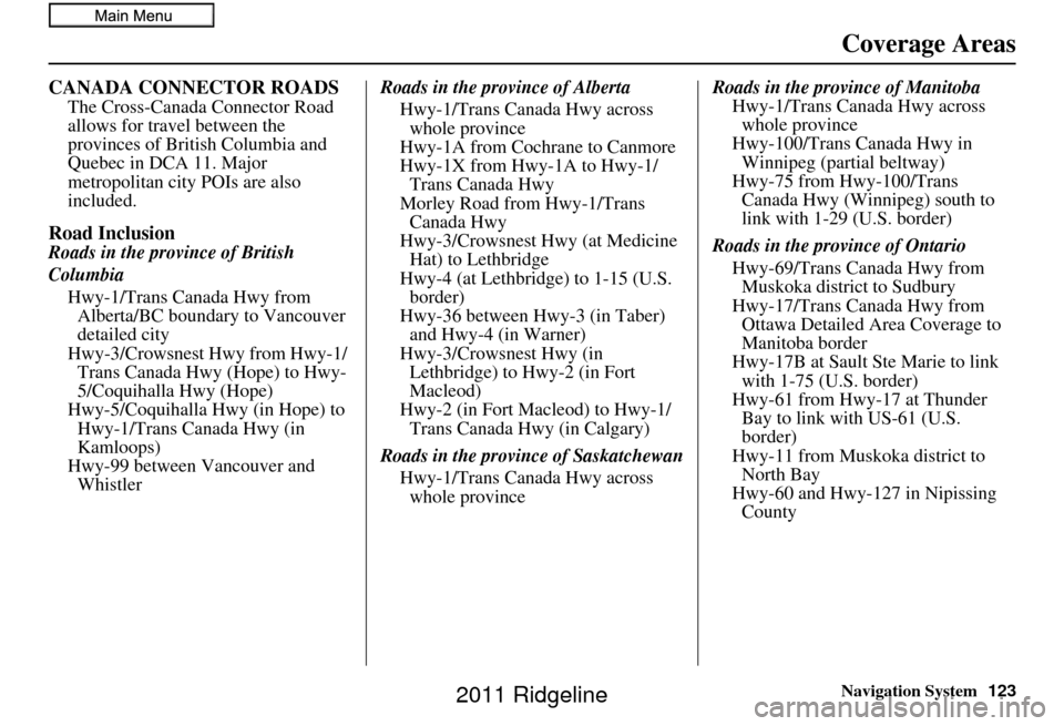
CANADA CONNECTOR ROADS
The Cross-Canada Connector Road
allows for travel between the
provinces of British Columbia and
Quebec in DCA 11. Major
metropolitan city POIs are also
included.
Road Inclusion
Roads in the province of British
Columbia
Hwy-1/Trans Canada Hwy from Alberta/BC boundary to Vancouver
detailed city
Hwy-3/Crowsnest Hwy from Hwy-1/ Trans Canada Hwy (Hope) to Hwy-
5/Coquihalla Hwy (Hope)
Hwy-5/Coquihalla Hwy (in Hope) to Hwy-1/Trans Canada Hwy (in
Kamloops)
Hwy-99 between Vancouver and Whistler Roads in the province of Alberta
Hwy-1/Trans Canada Hwy across whole province
Hwy-1A from Cochrane to Canmore
Hwy-1X from Hwy-1A to Hwy-1/ Trans Canada Hwy
Morley Road from Hwy-1/Trans Canada Hwy
Hwy-3/Crowsnest Hwy (at Medicine Hat) to Lethbridge
Hwy-4 (at Lethbridge) to 1-15 (U.S. border)
Hwy-36 between Hwy-3 (in Taber) and Hwy-4 (in Warner)
Hwy-3/Crowsnest Hwy (in Lethbridge) to Hwy-2 (in Fort
Macleod)
Hwy-2 (in Fort Macleod) to Hwy-1/ Trans Canada Hwy (in Calgary)
Roads in the province of Saskatchewan Hwy-1/Trans Canada Hwy across whole province Roads in the province of Manitoba
Hwy-1/Trans Canada Hwy across whole province
Hwy-100/Trans Canada Hwy in Winnipeg (partial beltway)
Hwy-75 from Hwy-100/Trans Canada Hwy (Winnipeg) south to
link with 1-29 (U.S. border)
Roads in the province of Ontario Hwy-69/Trans Canada Hwy from Muskoka district to Sudbury
Hwy-17/Trans Canada Hwy from Ottawa Detailed Area Coverage to
Manitoba border
Hwy-17B at Sault Ste Marie to link with 1-75 (U.S. border)
Hwy-61 from Hwy-17 at Thunder Bay to link with US-61 (U.S.
border)
Hwy-11 from Muskoka district to North Bay
Hwy-60 and Hwy-127 in Nipissing County
Coverage Areas
2011 Ridgeline
Page 124 of 151
124Navigation System
Coverage Areas
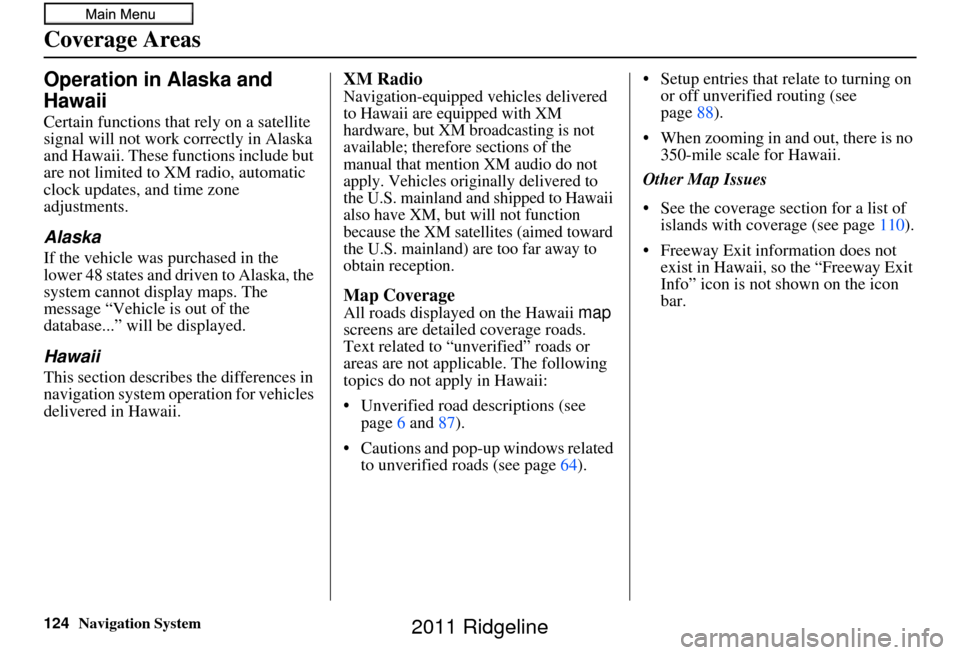
Operation in Alaska and
Hawaii
Certain functions that rely on a satellite
signal will not work correctly in Alaska
and Hawaii. These functions include but
are not limited to XM radio, automatic
clock updates, and time zone
adjustments.
Alaska
If the vehicle was purchased in the
lower 48 states and driven to Alaska, the
system cannot display maps. The
message “Vehicle is out of the
database...” will be displayed.
Hawaii
This section describes the differences in
navigation system operation for vehicles
delivered in Hawaii.
XM Radio
Navigation-equipped vehicles delivered
to Hawaii are equipped with XM
hardware, but XM broadcasting is not
available; therefore sections of the
manual that mention XM audio do not
apply. Vehicles originally delivered to
the U.S. mainland and shipped to Hawaii
also have XM, but will not function
because the XM satellites (aimed toward
the U.S. mainland) are too far away to
obtain reception.
Map Coverage
All roads displayed on the Hawaii map
screens are detailed coverage roads.
Text related to “unverified” roads or
areas are not applicable. The following
topics do not apply in Hawaii:
• Unverified road descriptions (see page 6 and 87).
• Cautions and pop-up windows related to unverified roads (see page 64).• Setup entries that relate to turning on
or off unverified routing (see
page 88).
• When zooming in and out, there is no 350-mile scale for Hawaii.
Other Map Issues
• See the coverage section for a list of islands with coverage (see page 110).
• Freeway Exit information does not exist in Hawaii, so the “Freeway Exit
Info” icon is not shown on the icon
bar.
2011 Ridgeline
Page 125 of 151
Navigation System125
Coverage Areas
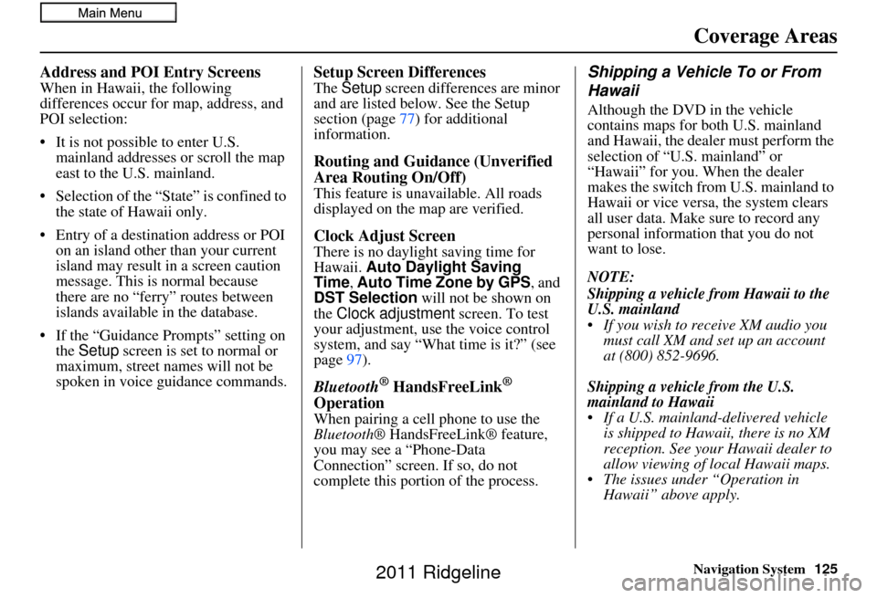
Address and POI Entry Screens
When in Hawaii, the following
differences occur for map, address, and
POI selection:
• It is not possible to enter U.S.
mainland addresses or scroll the map
east to the U.S. mainland.
• Selection of the “State” is confined to the state of Hawaii only.
• Entry of a destination address or POI on an island other than your current
island may result in a screen caution
message. This is normal because
there are no “ferry” routes between
islands available in the database.
• If the “Guidance Prompts” setting on the Setup screen is set to normal or
maximum, street names will not be
spoken in voice guidance commands.
Setup Screen Differences
The Setup screen differences are minor
and are listed below. See the Setup
section (page 77) for additional
information.
Routing and Guidance (Unverified
Area Routing On/Off)
This feature is unavailable. All roads
displayed on the map are verified.
Clock Adjust Screen
There is no daylight saving time for
Hawaii. Auto Daylight Saving
Time, Auto Time Zone by GPS , and
DST Selection will not be shown on
the Clock adjustment screen. To test
your adjustment, use the voice control
system, and say “What time is it?” (see
page 97).
Bluetooth® HandsFreeLink®
Operation
When pairing a cell phone to use the
Bluetooth ® HandsFreeLink® feature,
you may see a “Phone-Data
Connection” screen. If so, do not
complete this portion of the process.
Shipping a Vehicle To or From
Hawaii
Although the DVD in the vehicle
contains maps for both U.S. mainland
and Hawaii, the dealer must perform the
selection of “U.S. mainland” or
“Hawaii” for you. When the dealer
makes the switch from U.S. mainland to
Hawaii or vice versa, the system clears
all user data. Make sure to record any
personal information that you do not
want to lose.
NOTE:
Shipping a vehicle from Hawaii to the
U.S. mainland
If you wish to receive XM audio you must call XM and set up an account
at (800) 852-9696.
Shipping a vehicle from the U.S.
mainland to Hawaii
If a U.S. mainland -delivered vehicle
is shipped to Hawaii, there is no XM
reception. See your Hawaii dealer to
allow viewing of local Hawaii maps.
The issues under “Operation in Hawaii” above apply.
2011 Ridgeline
Page 126 of 151
126Navigation System
Frequently Asked Questions
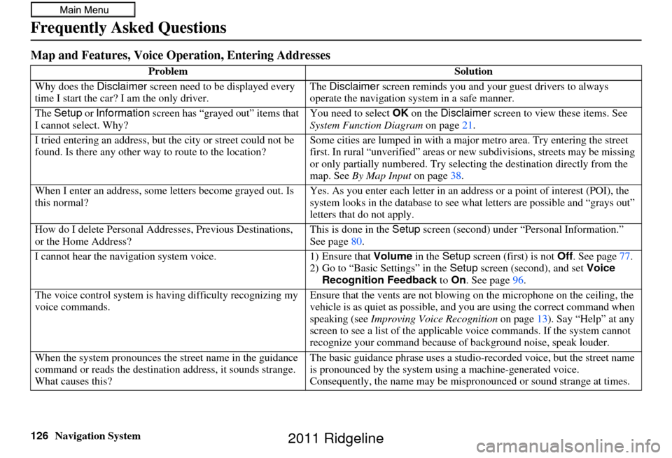
Map and Features, Voice Operation, Entering Addresses
Problem Solution
Why does the Disclaimer screen need to be displayed every
time I start the car? I am the only driver. The
Disclaimer screen reminds you and your guest drivers to always
operate the navigation sy stem in a safe manner.
The Setup or Information screen has “grayed out” items that
I cannot select. Why? You need to select
OK on the Disclaimer screen to view these items. See
System Function Diagram on page21.
I tried entering an address, but th e city or street could not be
found. Is there any other way to route to the location? Some cities are lumped in with a major metro area. Try entering the street
first. In rural “unverified” areas or ne
w subdivisions, streets may be missing
or only partially numbered. Try selecting the destination directly from the
map. See By Map Input on page38.
When I enter an address, some letters become grayed out. Is
this normal? Yes. As you enter each letter in an addr
ess or a point of interest (POI), the
system looks in the databa se to see what letters are possible and “grays out”
letters that do not apply.
How do I delete Personal Addre sses, Previous Destinations,
or the Home Address? This is done in the
Setup screen (second) under “P ersonal Information.”
See page 80.
I cannot hear the navigation system voice. 1) Ensure that Volume in the Setup screen (first) is not Off. See page 77.
2) Go to “Basic Settings” in the Setup screen (second), and set Voice
Recognition Feedback to On . See page 96.
The voice control system is ha ving difficulty recognizing my
voice commands. Ensure that the vents are not blowing on the microphone on the ceiling, the
vehicle is as quiet as
possible, and you are using the correct command when
speaking (see Improving Voice Recognition on page13). Say “Help” at any
screen to see a list of the applicable voice commands. If the system cannot
recognize your command because of background noise, speak louder.
When the system pronounces the street name in the guidance
command or reads the destinati on address, it sounds strange.
What causes this? The basic guidance phrase uses a studio
-recorded voice, but the street name
is pronounced by the system us ing a machine-generated voice.
Consequently, the name may be misp ronounced or sound strange at times.
2011 Ridgeline
Page 127 of 151
Navigation System127
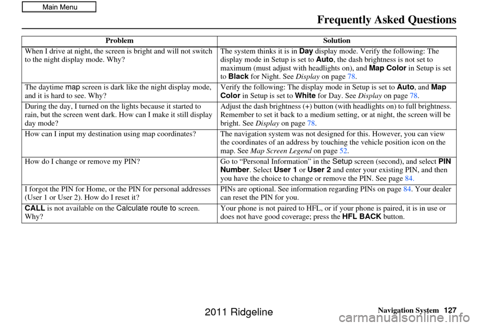
When I drive at night, the screen
is bright and will not switch
to the night display mode. Why? The system thinks it is in Day
display mode. Verify the following: The
display mode in Setup is set to Auto, the dash brightness is not set to
maximum (must adjust with headlights on), and Map Color in Setup is set
to Black for Night. See Display on page 78.
The daytime map screen is dark like the night display mode,
and it is hard to see. Why? Verify the following: The disp
lay mode in Setup is set to Auto, and Map
Color in Setup is set to White for Day. See Display on page 78.
During the day, I turned on the lights because it started to
rain, but the screen went dark. How can I make it still display
day mode? Adjust the dash brightness (+) button
(with headlights on) to full brightness.
Remember to set it back to a medium set ting, or at night, the screen will be
bright. See Display on page 78.
How can I input my destination using map coordinates? The navigation system was not designed for th is. However, you can view
the coordinates of an address by touching the vehicle position icon on the
map. See Map Screen Legend on page52.
How do I change or remove my PIN? Go to “Personal Information” in the Setup screen (second), and select PIN
Number . Select User 1 or User 2 and enter your existing PIN, and then
you have the choice to change or remove the PIN. See page84.
I forgot the PIN for Home, or the PIN for personal addresses
(User 1 or User 2). How do I reset it? PINs are optional. See information regarding PINs on page
84. Your dealer
can reset the PIN for you.
CALL is not available on the Calculate route to screen.
Why? Your phone is not paired to HFL, or if your phone is paired, it is in use or
does not have good coverage; press the
HFL BACK button.
Problem
Solution
Frequently Asked Questions
2011 Ridgeline
Page 128 of 151
128Navigation System
Frequently Asked Questions
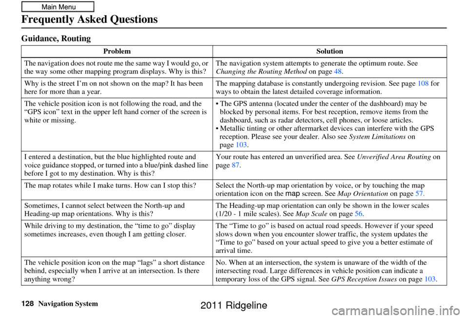
Guidance, Routing
ProblemSolution
The navigation does not route me the same way I would go, or
the way some other mapping progr am displays. Why is this?The navigation system attempts to
generate the optimum route. See
Changing the Routing Method on page48.
Why is the street I’m on not shown on the map? It has been
here for more than a year. The mapping database is
constantly undergoing revision. See page108 for
ways to obtain the latest de tailed coverage information.
The vehicle position icon is not following the road, and the
“GPS icon” text in the upper left hand corner of the screen is
white or missing. • The GPS antenna (located under th
e center of the dashboard) may be
blocked by personal items. For best reception, remove items from the
dashboard, such as radar detector s, cell phones, or loose articles.
• Metallic tinting or other aftermarke t devices can interfere with the GPS
reception. Please see your dealer. Also see System Limitations on
page 103.
I entered a destination, but th e blue highlighted route and
voice guidance stopped, or turned into a blue/pink dashed line
before I got to my dest ination. Why is this? Your route has entered
an unverified area. See Unverified Area Routing on
page 87.
The map rotates while I make turns. How can I stop this? Select the North-up map orientation by voice, or by touching the map
orientation icon on the map screen. See Map Orientation on page57.
Sometimes, I cannot select between the North-up and
Heading-up map orienta tions. Why is this? The Heading-up map orient
ation can only be shown in the lower scales
(1/20 - 1 mile scales). See Map Scale on page56.
While driving to my destinati on, the “time to go” display
sometimes increases, even though I am getting closer. The “Time to go” is based on actual
road speeds. However if your speed
slows down when you encounter slower traffic, the system updates the
“Time to go” based on your actual spee d to give you a better estimate of
arrival time.
The vehicle position icon on the map “lags” a short distance
behind, especially when I arrive at an intersection. Is there
anything wrong? No. When at an intersection, the syst
em is unaware of the width of the
intersecting road. Large differences in vehicle position can indicate a
temporary loss of the GPS signal. See GPS Reception Issues on page103.
2011 Ridgeline
Page 129 of 151
Navigation System129
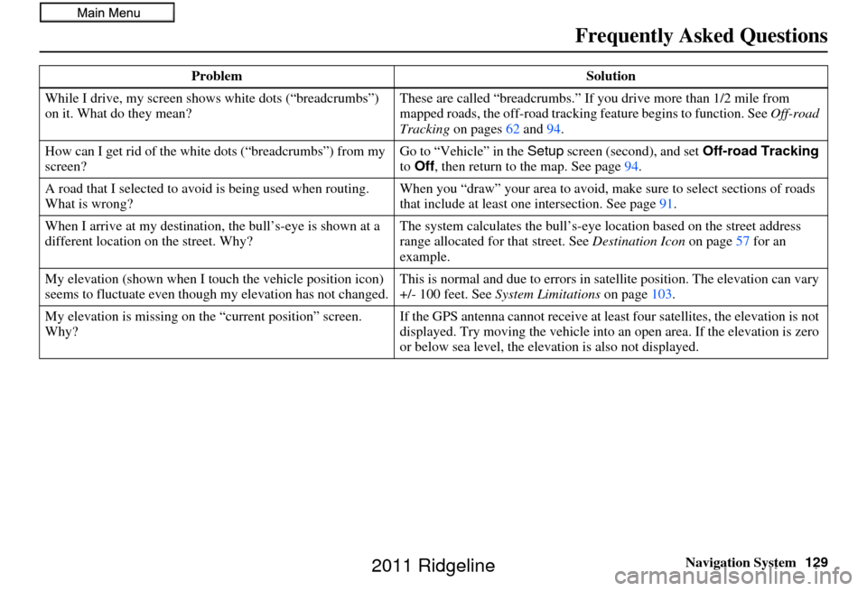
While I drive, my screen s
hows white dots (“breadcrumbs”)
on it. What do they mean? These are called “breadcrumbs.”
If you drive more than 1/2 mile from
mapped roads, the off-road tracking feature begins to function. See Off-road
Tracking on pages 62 and 94.
How can I get rid of the white dots (“breadcrumbs”) from my
screen? Go to “Vehicle” in the
Setup screen (second), and set Off-road Tracking
to Off , then return to the map. See page 94.
A road that I selected to avoi d is being used when routing.
What is wrong? When you “draw” your area to avoid, make
sure to select sections of roads
that include at least one intersection. See page91.
When I arrive at my destination, the bull’s-eye is shown at a
different location on the street. Why? The system calculates the bull’s-eye location based on th
e street address
range allocated for that street. See Destination Icon on page57 for an
example.
My elevation (shown when I t ouch the vehicle position icon)
seems to fluctuate even though my elevation has not changed. This is normal and due to errors in sa
tellite position. The elevation can vary
+/- 100 feet. See System Limitations on page103.
My elevation is missing on the “current pos ition” screen.
Why? If the GPS antenna cannot receive at least four satellites, the elevation is not
displayed. Try moving the vehicle into an open area. If the elevation is zero
or below sea level, the elev
ation is also not displayed.
Problem
Solution
Frequently Asked Questions
2011 Ridgeline
Page 130 of 151
130Navigation System
Frequently Asked Questions
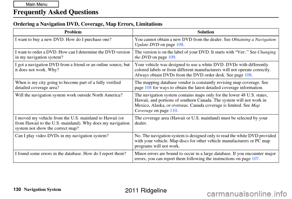
Ordering a Navigation DVD, Coverage, Map Errors, Limitations
ProblemSolution
I want to buy a new DVD. How do I purchase one ? You cannot obtain a new DVD from the dealer. See Obtaining a Navigation
Update DVD on page108.
I want to order a DVD. How ca n I determine the DVD version
in my navigation system? The version is on the label of your DVD. It starts with “Ver:.” See
Changing
the DVD on page 109.
I got a navigation DVD from a friend or an online source, but
it does not work. Why? Your vehicle was designed to use
a white DVD. DVDs with differently
colored labels or from different manuf acturers will not operate correctly.
Always obtain DVDs from the DVD order desk. See page 108.
When is my city going to become part of a fully verified
detailed coverage area? The mapping database vendor is constantly revising map coverage. See
page
108 for ways to obtain the latest detailed coverage information.
Will the navigation system work outside North America? The navi gation system contains maps only for the lower 48 U.S. states,
Hawaii, and portions of s outhern Canada. The syst em will not work in
Mexico, Alaska, or ove rseas. Canada coverage is limited. See Map
Coverage on page110.
I moved my vehicle from the U.S. mainland to Hawaii (or
from Hawaii to the U.S. mainland). Why does my navigation
system not show the correct map? The coverage area (Hawai
i or U.S. mainland) must be selected by your
dealer.
Can I play video DVDs in my navigation sy stem?No. The navigation system is designed only to read the white DVD provided
with your vehicle. Map di scs for other vehicle manufacturers or PC map
programs will not work.
I found some errors in the database. How do I report them? Mi nor errors are bound to occur in a large database. If you encounter major
errors, you can report them following the instructions on page 107.
2011 Ridgeline