tire type INFINITI QX70 2017 Navigation Manual
[x] Cancel search | Manufacturer: INFINITI, Model Year: 2017, Model line: QX70, Model: INFINITI QX70 2017Pages: 268, PDF Size: 11.86 MB
Page 148 of 268

7. Viewing technical information
7-2
INFORMATION SCREEN
This screen sets or displays various
information that is helpful for using the
vehicle safely and comfortably.
Available items include the vehicle infor-
mation, Infiniti Connection
TM(if so
equipped), Traffic Info. setup, current loca-
tion information, GPS information, Voice
recognition list and map version.
INFO:
.
A NavTraffic subscription is necessary to
view Traffic Info.
.[Infiniti Connection] is a feature of Infiniti
Connection. Use of this feature is dependent
upon a valid subscription and the telematics
device being in operative condition, as well
as cellular connectivity, navigation map
data and GPS satellite signal reception
being available.
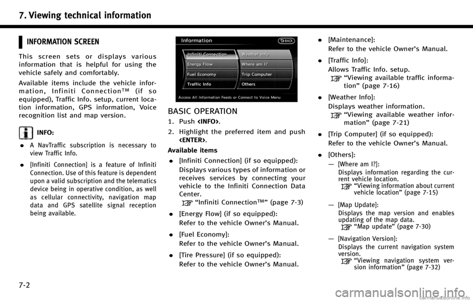
BASIC OPERATION
1. Push
2. Highlight the preferred item and push
Available items . [Infiniti Connection] (if so equipped):
Displays various types of information or
receives services by connecting your
vehicle to the Infiniti Connection Data
Center.
“Infiniti ConnectionTM”(page 7-3)
. [Energy Flow] (if so equipped):
Refer to the vehicle Owner’s Manual.
. [Fuel Economy]:
Refer to the vehicle Owner’s Manual.
. [Tire Pressure] (if so equipped):
Refer to the vehicle Owner’s Manual. .
[Maintenance]:
Refer to the vehicle Owner’s Manual.
. [Traffic Info]:
Allows Traffic Info. setup.
“Viewing available traffic informa-
tion” (page 7-16)
. [Weather Info]:
Displays weather information.
“Viewing available weather infor-
mation” (page 7-21)
. [Trip Computer] (if so equipped):
Refer to the vehicle Owner’s Manual.
. [Others]:
—
[Where am I?]:
Displays information regarding the cur-
rent vehicle location.
“Viewing information about current
vehicle location” (page 7-15)
—[Map Update]:
Displays the map version and enables
updating of the map data.
“Map update” (page 7-30)
—[Navigation Version]:
Displays the current navigation system
version.
“ Viewing navigation system ver-
sion information” (page 7-32)
Page 227 of 268

.When the vehicle is rotated on a
parking lot turntable while the ignition
switch is off.
.When driving on a road not displayed
on the map screen or a road that has
been changed due to additional con-
struction or other reasons.
.When the GPS positioning accuracy is
low.
INFO:
.
The vehicle icon may be misaligned when
starting the vehicle just after starting the
engine or the hybrid system.
.The vehicle icon may also be misaligned if
different sized tires or tire chains are
installed.
.The system has a function that automati-
cally corrects the vehicle icon position when
it is misaligned from the actual position.
.Vehicle position correction by GPS may not
function when the vehicle is stopped.
.If the vehicle icon position does not return
to normal even after driving for a while,
correct the vehicle icon position manually.
“Adjusting current vehicle location”
(page 8-9)
DETAILED MAP COVERAGE AREAS
(MCA) FOR NAVIGATION SYSTEM
This system is designed to help guiding to
the destination, and it also performs other
functions as outlined in this manual.
However, the system must be used safely
and properly. Information concerning road
conditions, traffic signs and the availability
of services may not always be up-to-date.
The system is not a substitute for safe,
proper and legal driving. Map data covers
select metropolitan areas in the United
States and Canada.
Map data includes two types of areas:
“ Detailed coverage areas” providing all
detailed road data and other areas show-
ing “Main roads only”.
NOTE:
Detailed map data is not available in many
areas and is generally limited to select major
metropolitan areas.
10. General system information
10-7