display Lexus GX460 2015 Navigation Manual
[x] Cancel search | Manufacturer: LEXUS, Model Year: 2015, Model line: GX460, Model: Lexus GX460 2015Pages: 401, PDF Size: 14.2 MB
Page 74 of 401

73
1. BASIC OPERATION
3
NAVIGATION SYSTEM
GX460_Navi_OM60L77U_(U)14.06.02 10:48
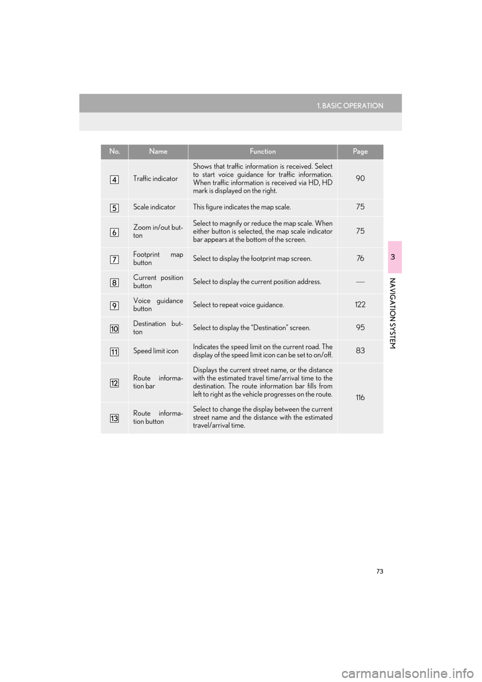
Traffic indicator
Shows that traffic information is received. Select
to start voice guidance for traffic information.
When traffic information is received via HD, HD
mark is displayed on the right.
90
Scale indicatorThis figure indicates the map scale.75
Zoom in/out but-
tonSelect to magnify or reduce the map scale. When
either button is selected, the map scale indicator
bar appears at the bottom of the screen.75
Footprint map
buttonSelect to display the footprint map screen.76
Current position
buttonSelect to display the current position address.
Voice guidance
buttonSelect to repeat voice guidance.122
Destination but-
tonSelect to display the “Destination” screen. 95
Speed limit iconIndicates the speed limit on the current road. The
display of the speed limit icon can be set to on/off.83
Route informa-
tion bar
Displays the current street name, or the distance
with the estimated travel time/arrival time to the
destination. The route information bar fills from
left to right as the vehicle progresses on the route.
116
Route informa-
tion buttonSelect to change the display between the current
street name and the distance with the estimated
travel/arrival time.
No.NameFunctionPa g e
GX_Navi_OM60L77U_(U).book Page 73 Monday, June 2, 2014 10:49 AM
Page 75 of 401

74
1. BASIC OPERATION
GX460_Navi_OM60L77U_(U)14.06.02 10:48
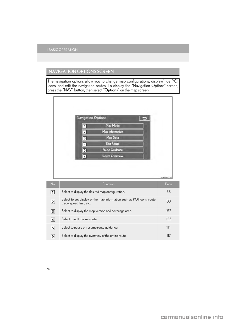
NAVIGATION OPTIONS SCREEN
The navigation options allow you to change map configurations, display/hide POI
icons, and edit the navigation routes. To display the “Navigation Options” screen,
press the “NAV” button, then select “Options” on the map screen.
No.FunctionPage
Select to display the desired map configuration.78
Select to set display of the map information such as POI icons, route
trace, speed limit, etc.83
Select to display the map version and coverage area.152
Select to edit the set route.123
Select to pause or resume route guidance.114
Select to display the overview of the entire route.117
GX_Navi_OM60L77U_(U).book Page 74 Monday, June 2, 2014 10:49 AM
Page 76 of 401

75
1. BASIC OPERATION
GX460_Navi_OM60L77U_(U)14.06.02 10:48
3
NAVIGATION SYSTEM
2. MAP SCREEN OPERATION
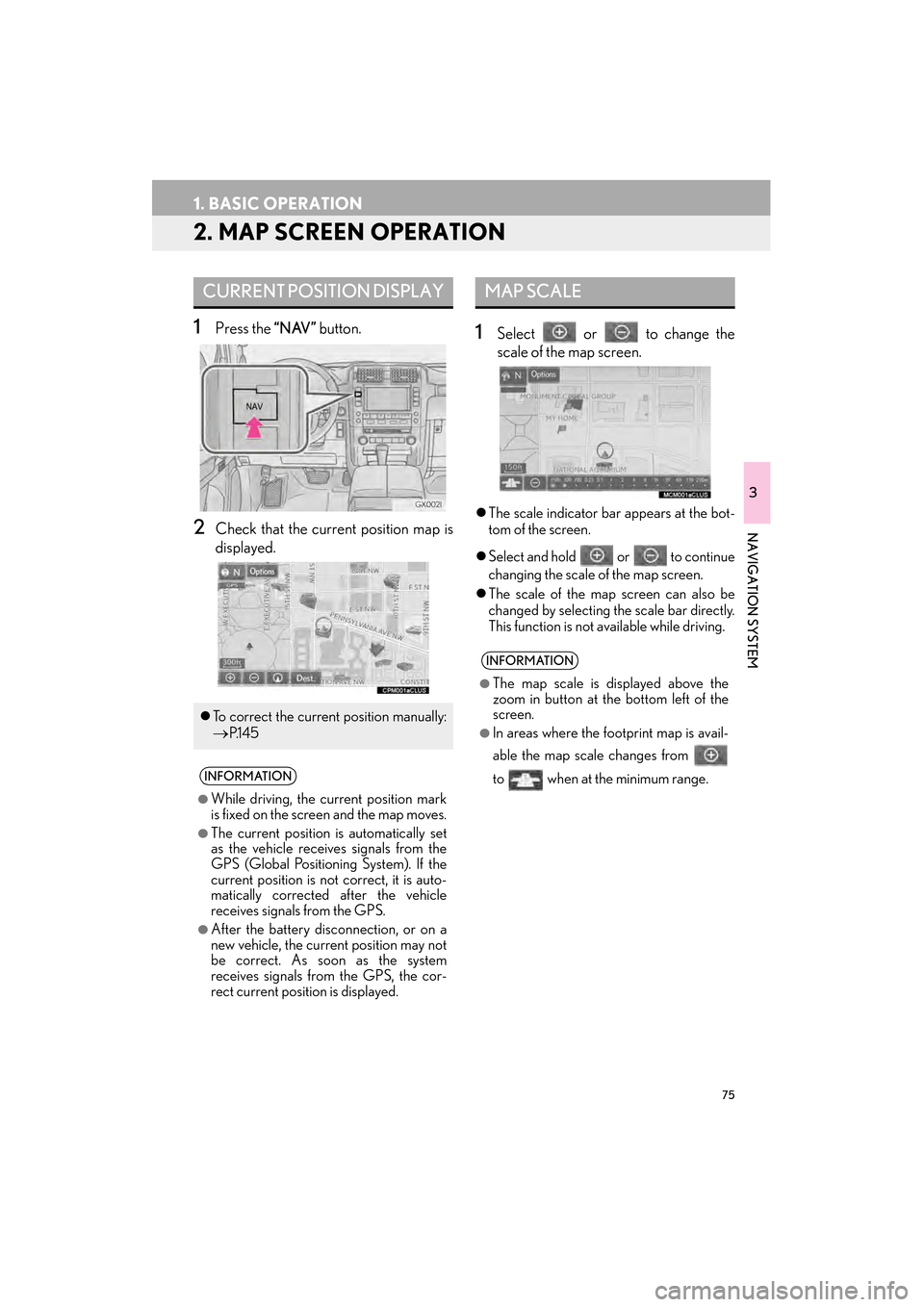
1Press the “NAV” button.
2Check that the current position map is
displayed.
1Select or to change the
scale of the map screen.
�zThe scale indicator bar appears at the bot-
tom of the screen.
�z Select and hold or to continue
changing the scale of the map screen.
�z The scale of the map screen can also be
changed by selecting the scale bar directly.
This function is not available while driving.
CURRENT POSITION DISPLAY
�zTo correct the current position manually:
→P.1 4 5
INFORMATION
●
While driving, the current position mark
is fixed on the screen and the map moves.
●The current position is automatically set
as the vehicle receives signals from the
GPS (Global Positioning System). If the
current position is not correct, it is auto-
matically corrected after the vehicle
receives signals from the GPS.
●After the battery disconnection, or on a
new vehicle, the current position may not
be correct. As soon as the system
receives signals from the GPS, the cor-
rect current position is displayed.
MAP SCALE
INFORMATION
●
The map scale is displayed above the
zoom in button at the bottom left of the
screen.
●In areas where the footprint map is avail-
able the map scale changes from
to when at the minimum range.
GX_Navi_OM60L77U_(U).book Page 75 Monday, June 2, 2014 10:49 AM
Page 77 of 401

76
1. BASIC OPERATION
GX460_Navi_OM60L77U_(U)14.06.02 10:48
1Select on the map screen.
2Check that the footprint map is dis-
played.
�zTo return to the normal map display, select
. �z
To display the normal map, select .
FOOTPRINT MAP
For areas covered by the footprint map
(some major cities), a footprint map on a
scale of 75 ft. (25 m) can be selected.
When the map is scaled down to 150 ft.
(50 m), changes to and can
be selected to display the footprint map.
INFORMATION
●
If the map or the current position is
moved to the area which is not covered
by the footprint map, the screen scale
automatically changes to 150 ft. (50 m).
●On the footprint map, a one way street is
displayed by .
●Scrolling on the footprint map is not avail-
able while driving.
Building footprints in the database were
created and provided by NAVTEQ.
3D CITY MODEL MAP
A 3D city model map can be displayed
for some areas in major cities when the
map scale is 700 ft. (200 m) or less on
the 3D map screen.
INFORMATION
●
The 3D city model map can be set the
display on/off. ( →P.141)
GX_Navi_OM60L77U_(U).book Page 76 Monday, June 2, 2014 10:49 AM
Page 78 of 401

77
1. BASIC OPERATION
3
NAVIGATION SYSTEM
GX460_Navi_OM60L77U_(U)14.06.02 10:48
1Select an arrow to rotate.
1Select , or .
�X North-up screen
�X Heading-up screen
�X 3D screen
ROTATING 3D MAP
3D map and 3D city model map can be
rotated when arrows appear around the
cursor while scrolling.
INFORMATION
●
The viewing angle of the 3D map can be
changed. ( →P.144)
ORIENTATION OF THE MAP
The orientation of the map can be
changed between 2D north-up, 2D
heading-up and 3D heading-up by se-
lecting the orientation symbol displayed
at the top left of the screen.
GX_Navi_OM60L77U_(U).book Page 77 Monday, June 2, 2014 10:49 AM
Page 80 of 401

79
1. BASIC OPERATION
3
NAVIGATION SYSTEM
GX460_Navi_OM60L77U_(U)14.06.02 10:48
�zDepending on the conditions, certain
screen configuration buttons cannot be
selected.
■ MAP ONLY
■ DUAL MAP
�zThe map on the left is the main map.
No.FunctionPage
Select to display the single
map screen. 79
Select to display the dual
map screen.79
Select to display the com-
pass mode screen.80
Select to display the turn list
screen.120
Select to display the freeway
exit list screen.118
Select to display the inter-
section guidance screen or
the guidance screen on the
freeway.
120
Select to display the turn-
by-turn arrow screen.121
GX_Navi_OM60L77U_(U).book Page 79 Monday, June 2, 2014 10:49 AM
Page 81 of 401

80
1. BASIC OPERATION
GX460_Navi_OM60L77U_(U)14.06.02 10:48
�XEditing right map
1Select any point on the right side map.
2Select the desired item.
�zWhen set to on, the indicator will illuminate.
■ COMPASS
The right side map can be edited.
No.FunctionPage
Select to change the orien-
tation of the map.77
Select to display POI icons.84
Select to show traffic infor-
mation. 90
Select to display eDestina-
tion icons.368
Select to change the map
scale.75
Information about the destination, cur-
rent position and a compass is displayed
on the screen.
INFORMATION
●
The destination mark is displayed in the
direction of the destination. When driv-
ing, refer to the longitude and latitude
coordinates, and the compass, to make
sure that the vehicle is headed in the
direction of th e destination.
●When the vehicle travels out of the cover-
age area, the guidance screen changes to
the whole compass mode screen.
GX_Navi_OM60L77U_(U).book Page 80 Monday, June 2, 2014 10:49 AM
Page 82 of 401

81
1. BASIC OPERATION
3
NAVIGATION SYSTEM
GX460_Navi_OM60L77U_(U)14.06.02 10:48
�zTo scroll over the map screen, touch the
screen with your finger, and move the
screen to the desired position or quickly
move the screen by flicking with your finger.
(→ P. 3 0 )
�z If a finger touches and holds the map
screen, it will continue scrolling in that
direction until the finger is removed. (3D
map only)SCREEN SCROLL
OPERATION
Use the scroll feature to move the de-
sired point to the center of the screen for
looking at a point on the map that is dif-
ferent from the current position.
No.Information/Function
Cursor mark
Distance from the current position to
the cursor mark.
Select to set as a destination.
When selecting “Go to ” on the fol-
lowing map screen, the navigation
system performs a search for the
route. ( →P.110)
If a destination has already been set,
“Go to ” and “Add to Route” will be
displayed.
“Go to ” : Select to delete the exist-
ing destination(s) and set a new one.
“Add to Route” : Select to add a desti-
nation.
Select to register as a memory point.
To change the icon, name, etc.:→P.134
Select to return to the current posi-
tion.
GX_Navi_OM60L77U_(U).book Page 81 Monday, June 2, 2014 10:49 AM
Page 84 of 401

83
1. BASIC OPERATION
GX460_Navi_OM60L77U_(U)14.06.02 10:48
3
NAVIGATION SYSTEM
3. MAP SCREEN INFORMATION
1Select “Options” on the map screen.
2Select “Map Information” .
3Select the desired items to be displayed.
�zWhen set to on, the indicator will illuminate.
DISPLAYING MAP
INFORMATION
Information such as POI icons, route
trace, speed limit, etc. can be displayed
on the map screen.
No.FunctionPage
Select to display the select-
ed POI icons.
Select to select or change
POI icons.84
Select to display eDestina-
tions.368
Select to display route trace.86
Select to display traffic infor-
mation.90
Select to display speed limit
icon.
GX_Navi_OM60L77U_(U).book Page 83 Monday, June 2, 2014 10:49 AM
Page 85 of 401

84
1. BASIC OPERATION
GX460_Navi_OM60L77U_(U)14.06.02 10:48
1Display the “Map Information” screen.
(→ P.83)
2Select “Select POI” .
�zWhen the POI icons to be displayed on the
map screen have already been set,
“Change POI” is displayed.
3Select the desired POI category and se-
lect “OK” .SELECTING THE POI ICONS
No.Information/FunctionPage
Displays up to 5 selected
POI icons on the map
screen.−
Select to cancel the select-
ed POI icons.−
Displays up to 6 POI icons
as favorite POI categories143
Select to display other POI
categories if the desired
POIs cannot be found on
the screen.
85
Select to search for the
nearest POIs.85
GX_Navi_OM60L77U_(U).book Page 84 Monday, June 2, 2014 10:49 AM