sat nav MERCEDES-BENZ C-Class 2011 W204 Comand Manual
[x] Cancel search | Manufacturer: MERCEDES-BENZ, Model Year: 2011, Model line: C-Class, Model: MERCEDES-BENZ C-Class 2011 W204Pages: 190, PDF Size: 2.21 MB
Page 12 of 190
Opera
tingsafet y General
notes G
War
ning
An yalteration sof electr oniccompon entsor
soft ware cancause malfunct ions.
Radio, satellite radio,amplifier, DVDchanger ,
navigation module,telephon eand Voice
Contr olsystems areinter connect ed.
Therefor e,ifone ofthe compon entsis not
operation al,orhas notbeen removed/
replaced properly, thefunc tion ofother
compon entscould beimpaired.
Such conditions mightseriously impairthe
operatin gsafety ofyour vehicle.
We recom mendtohave anyservic ework on
electr oniccompon entscarried outbyan
authoriz edMercedes- BenzCenter . G
War
ning
In order toavoid distrac tionwhich couldlead
to an acciden t,the driver should entersystem
sett ings while thevehicle isat astan dstill, and
operate thesystem onlywhen permitt edby
road, weather andtrafficcon ditions .
Bear inmind thatataspeed ofjust 30mph
(approximat ely50km/ h),your carcover sa
distanc eof 44 feet (approximat ely14m) every
secon d.
COMAND suppliesyouwith information to
help youselect yourroute moreeasily and
guide youconvenien tlyand safely toyour
destin ation. Forsafety reasons, we
enco urage thedriver tostop thevehicle ina
safe place before answering orplacing acall,
or con sulting theCOMAND screentoread
navigation almaps, instruct ions, or
downloaded information . G
War
ning
While thenavigation systemprovides
direct ionalassistanc e,the driver mustremain
focused onsafe driving behavior, especially
atten tiontotraff icand streetsigns, and should
utilizethesystem’s audiocueswhile
driving.
The navigation systemdoesnotsupply any
infor mation onstop signs, yieldsigns, traffic
regulations ortraff icsafety rules.Their
observan cealway sremains inthe driver’s
personal responsibility.DVDmaps donot
cover allareas norallroutes withinanarea.
This device complies withPart15ofthe FCC
Rules. Operation issubject tothe following
two conditions :
1. This device maynotcause harmful
int erferen ce,and
2. This device mustaccept anyinterferen ce
received, includinginterferen cethat may
cause undesired operation. G
War
ning
Change ormodificat ionnot express ly
approved bythe party respons iblefor
complianc ecould voidtheuser's authorit yto
operate thisequipment.
! Note: Thisequipment hasbeen tested
and found tocomply withthelimits fora
Class Adigital device,pursuan ttoPart 15
of the FCC Rules. Theselimitsaredesigned
to provide reasonable protectionagainst
harmful interference whentheequipment
is operated inacommer cialenviron ment.
This equipment generates,usesandcan
radiate radiofrequency energyand,ifnot
installed andused inaccordanc ewith the
instr uction manual, maycause harmful
inter ferenc eto radio communic ations. G
War
ning
This equipment complieswithFCCradiation
exposure limitssetforth foruncon trolled
equipment andmeets theFCC radio
frequency (RF)Exposure Guidelinesin
Supplement Cto OET65 .
This equipment hasvery lowlevels ofRF
energy thatisdeemed tocomply without
maximum permissive exposureevaluation
(MPE). Butitis desirable thatitshould be 10
Introdu
ction ZA
COMAND NTG4.0BR204USAEdition A2011; 1;3,en-US
d2irenk lV ersion:3.0.3.6
2010
-05-31T09 :21:57+0 2:00-Seite 10
Page 16 of 190
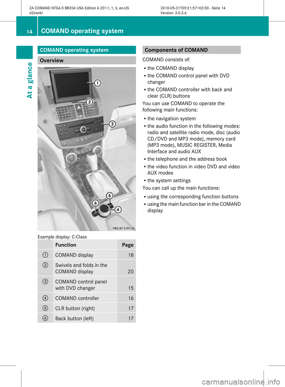
COMAN
Doper ating syst em Over
view Ex
ample display:C-Clas s Funct
ion Pag
e :
COMA
NDdispl ay 18
;
Swiv
elsand foldsin the
COMA NDdispl ay 20
=
COMA
NDcontrol pane l
wit hDV Dch ang er 15
?
COMA
NDcontroll er 16
A
CLR
button( right) 17
B
Back
button (left) 17 Co
mponen tsof COMA ND
COMAND consistsof:
R the COMAND display
R the COMAND controlpanelwithDVD
changer
R the COMAND controller withback and
clea r(CLR) buttons
You canuseCOMA NDtooper atethe
fol lowin gmain function s:
R thenav igat ionsyst em
R theaudio function inthef ollowing modes:
radio andsatellite radiomode, disc(audi o
CD/D VDand MP3 mode), memory card
(MP3 mode), MUSIC REGISTER, Media
Int erface andaudio AUX
R the telephone andtheaddress book
R the video functioninvideo DVDandvideo
AUX modes
R the system settings
You cancallupthe main functions:
R using thecorrespon dingfunct ionbutton s
R using themain functionbar inthe COMAND
display 14
COMAND
operatingsystemAtaglance
ZACOMAND NTG4.0BR204USAEdition A2011; 1;3,en-US
d2irenk lV ersion:3.0.3.6
2010
-05-31T09 :21:57+0 2:00-Seite 14
Page 21 of 190

Navi Au
dio Tel Vide
o Sys
tem Ma
pdisp lay FM/AM
radio Te
leph one Vi
de oDVD Ca
lls up the
sy ste mm enu Set
tingroute
calculation mode SatRadio Address
book Avoidin
gan area Disc
Recording
theroute Memory
card Traffic
information on
map MUSIC
REGISTE R Inf
ormat iononmap Media
Int erface O
Topographical
map on/off Rear
O
Switc hesfreeway
infor mation on/off AUX
O
Autom atically
read aloud traffic
report son/ off O
Volume limiter
on/ off SIRIUS
service System
menuoverview Sett
ings Language
Display
settings Set
tingthe language Time
Reading
speed Voice-
operated control settings Rear
viewcamera Ac
tivat ing/deac tivatingBluetoot h® COMAND
operatingsystem
19Ataglance
ZACOMAND NTG4.0BR204USAEdition A2011 ;1; 3,en-U S
d2irenk lV ersion:3.0.3.6
2010
-05-31T09 :21:57+0 2:00-Seite 19
Page 24 of 190

X
To confi rm your selecti on:pre ssbutton
a.
X To confi rm the mes sage:pre ssthe
a or% button. Men
usand submen us
The num bero fm enus depends onthe vehicle
equipment. Menu Functions
andsubmenu s Navigation
system Navigation
systemdisplays Audio Select
sa stat ion
Operates theDVD changer ,
memory card,MUSIC
REGISTE R,Media Interface
Operates videoDVD Telephone Ac
cept s/rej ectsa call
Makes/ endsacall
Select sa phone bookentry
Redials Nav
igation system menu
Rout eguida nceinactive The
display showstheroad onwhich the
vehicle iscurren tlytravelin g,provided the
digital mapcontains it.
Rout eguida nceactive The
display shows:
R the distanc eto the destin ation
R the distanc eto the nextchange ofdirection
R current street
R the travel direction arrow If
achange ofdirection isimminent ,the
displa yshows:
R the road youwillbeturning onto
R the distance tothe next change ofdirection
and adistance graphic
R aright orleft-t urnarrow
Lane recommen dationsarealso shown inthe
displa y,provided thedigital mapcontains the
necessary data.During achange ofdirection,
the number oflanes mayincrease. Lane
recommen dationsareshown inthe displa yas
a line with anarrow. Audio
menu
Adjust ingthe volume X
Press theW orX button.
Setting thestat ion/c hannel X
Switch onCOMAND (Ypage 31).
X Switch onFM /AM radio (Ypage 120)or
SatRadio (Ypage 124).
X In the multifunction display,select the
audi omenu usingthe= or; button.
X To selec tthe next/ previo usstation /
chann elfrom thememory: brieflypress
the : or9 button.
X To selectthe next/ previo usstation /
chann el:press andhold the: or
9 button.
Operating theDVD chang er/memo ry
card/MUS ICREGI STER/Me dia
Inte rface X
Switch onCOMAND (Ypag e31).
X Switch onDisc, Memory
Card (Ypag e131), MUSIC
REGISTE R(Y pag e139) orMedia
Int. (Ypag e143).
X In the multifunction display, sele ctthe
au dio menu using the = or; button. 22
Multifunc
tionsteering wheelAtaglan ce
ZACOMAND NTG4.0BR204USAEdition A2011; 1;3,en-US
d2ire nkl Version:3.0.3.6
<003000230024002300250023002000250035002400490023002C002D00300024
002D00200034003300230030002D00230023V
-Seite 22
Page 75 of 190
If
the vehicle reaches anarea which isnot part
of the digitalmap, thedisp layapp ears asa
spli t-screen view.Onthe right-hand side,an
arrow appears which points tooff-road
destination :.Youwill hear the
announc ement:"Please followthearrow on
the display" .Asthe vehicle approachesthe
destination, theArea ofdestination
reached message appears.
Route guidance fromanoff-road
location toad esti nation If
th eveh icle posit ioniswith inthearea
cov ered bythedigit almap, butthemap does
no tcon tain anyinform ationabout that
locat ion,th eveh icle isin an off-road locat ion.
COMA NDisalso able toguide youtoa
dest inationeven from anoff-road locat ion.
At thest art oftherout eguidan ce,you willsee
th eOff Mapped Roadmes sage, anarro w
and thedist anceto thed estin ation. Thearrow
shows thecompass headingtothe actual
destin ation.
The route ishighlighted blue,startingfrom
the last recogn izedstreet the vehicle wason
before itleft themap.
As soon asthe vehicle isback onaroad
kn own tothe system, routeguidance
con tinues inthe usual way.
Rout eguida ncefrom anoff-m ap
location toad esti nation If
th eveh icle posit ionisouts idethearea
cov ered bythedigit almap, then theveh icle
is in an off-map locat ion.COMAND isalso
able toguide youtoadestination evenfrom
an off-map location.
At the start ofthe route guidance,youwillsee
the Off Mapped Roadmessage, anarrow
and thedistance tothe destination. Thearrow
shows thecompass headingtothe road left
last.
The route ishighlig htedbluefrom thenearest
road known tothe system. As
soon asthe vehicle isback onaroad
known tothe system, routeguidance
cont inues inthe usua lway .
Off-road duringrouteguidance Due
toroad const ruction work,forexample,
there maybedifferences betweenthedata
on the digital mapandtheactual course of
the road.
In such cases, thesystem willtemporarily be
unable tolocate thevehicle position onthe
digital mapandthus considers thevehicle to
be inan off-road position.
In the displa y,you willsee theOff Mapped
Road message, anarrow andthedistance to
the destination. Thearrow shows the
compass headingtothe actual destination.
As soon asthe system canassign thevehicle
position tothe map again,route guidance
cont inues inthe usua lway . Tra
ffic report s Condition
s
To receive real-time trafficreports via
satellite radio,yourequire:
R optionally available satellite radio
equi pment
R asubscription toSIRIUS XMSatellite Radio
Traffic Message Service
Further information onsatellite radiois
avail able inthe "Satellite radio"section
(Y page 123).
COMAND canreceive trafficreports via
satellite radioandtake these intoaccount for
route guidanceinthe navigation system.
Received trafficreports aredispla yedinthe
map either astext oras icons. Real-time
traffic report son the map
COMAND canshow certain trafficincidents
on the map. Traffic reports areshown onthe
map atscales of0.05 mito20 mi. Tr
affic report s
73Navigat ion
ZACOMAND NTG4.0BR204USAEdition A2011; 1;3,en-US
d2irenkl Version:3.0.3.6
2010-0
5-31T09: 21:57+02:00-Seite 73 Z
Page 77 of 190
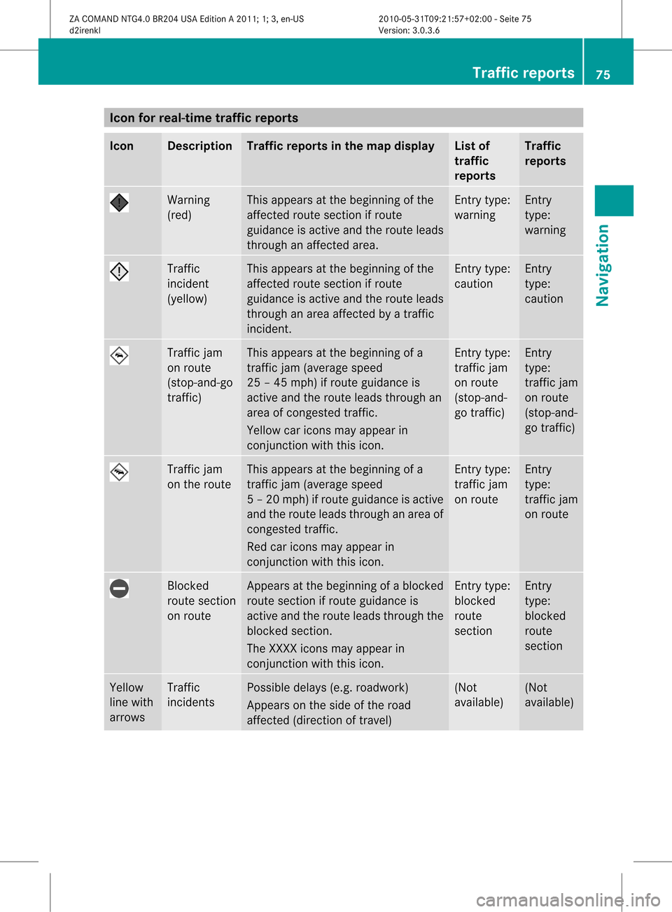
Icon
forreal-tim etraf fic rep orts Icon Descr
iption Tr
affic rep ortsin thema pdis pla y List
of
tr af fic
rep orts Tr
affic
rep orts Warn
ing
(re d) This
appear sat thebegi nning ofthe
aff ectedrout esec tion ifrout e
guidan ceisact ive and therout eleads
th roug han affectedarea. En
try typ e:
warn ing En
try
typ e:
warn ing Traf
fic
inc iden t
(yello w) This
appear sat thebegi nning ofthe
aff ectedrout esec tion ifrout e
guidan ceisact ive and therout eleads
th roug han area affectedby atraff ic
inc iden t. En
try typ e:
caut ion En
try
typ e:
caut ion Traf
ficjam
on rout e
(st op- and -go
tr aff ic) This
appear sat thebegi nning ofa
tr aff icjam (average speed
25 –45 mph )if rout eguidan ceis
act ive and therout eleads throug han
area ofcong est ed traff ic.
Yello wcar icons may appear in
co njunc tion withth is ico n. En
try typ e:
tr aff icjam
on rout e
(st op- and -
go traff ic) En
try
typ e:
tr aff icjam
on rout e
(st op- and -
go traff ic) Traf
ficjam
on therout e This
appear sat thebegi nning ofa
tr aff icjam (average speed
5–2 0mph)ifroute guidance isactiv e
and theroute leads through anarea of
con gested traffic.
Red caricon smay appear in
con junc tion with thisicon. En
try type:
traf ficjam
on route En
try
type:
traf ficjam
on route Block
ed
route section
on route Appears
atthe beginn ingofablock ed
route sectionifroute guidance is
activ eand theroute leads through the
block edsect ion.
The XXXX iconsmay appear in
con junc tion with thisicon. En
try type:
block ed
route
sect ion En
try
type:
block ed
route
sect ion Yellow
line with
arrows Traffic
inciden ts Possible
delays(e.g.roadwork )
Appears onthe side ofthe road
affec ted(direct ionoftrav el) (Not
available) (Not
available) Tr
aff icrep orts
75Navigat ion
ZACOMAND NTG4.0BR204USAEditionA2011 ;1; 3,en- US
d2iren kl Version:3.0 .3.6
2010
-05-31T09: 21:57+0 2:00-Seite 75 Z
Page 89 of 190
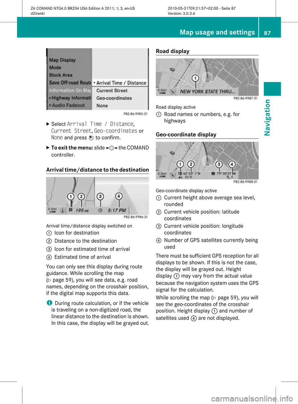
X
Sel ect ArrivalTim e/Dis tance,
Cur rentStr eet,Geo -coordinates or
Non eand pressW toconfi rm.
X To exitthe men u:slide XVY theCOMAND
control ler.
Arri valtime /distan cetothe destinatio n Arri
valtime /distanc edispl ayswitche don
: Icon fordestina tion
; Dista ncetothe destina tion
= Icon foresti mate dtime ofarr ival
? Estima tedtime ofarr ival
Yo ucan onlysee this displ ayduring route
gu idance .While scrolling themap
(Y page 59),youwillsee data, e.g.road
names, depending onthe crosshair position,
if the digital mapsupports thisdata.
i During routecalculation, orifthe vehicle
is traveling onanon- digitized road,the
linear distance tothe destination isshown.
In this case, thedispla ywill begrayed out.Road
display Road
display active
: Road names ornumbers, e.g.for
highway s
Geo-coo rdinatedisplay Geo-coordinate
displayactive
: Current heightaboveaverage sealevel,
rounded
; Current vehicleposition: latitude
coordinates
= Current vehicleposition: longitude
coordinates
? Number ofGPS satellites currentlybeing
used
There mustbesufficient GPSreception forall
displa ystobe shown. Ifthis isnot thecase,
the displa ywill begrayed out.Height
displa y: may varyfrom theactual value
because thenavigation systemusestheGPS
signal forthe calculation.
While scrolling themap (Ypage 59),youwill
see thegeo-coordinates ofthe crosshair
position. Heightdisplay: and number of
satellites used?are not displa yed. Map
usage andsettings
87Navigation
ZACOMAND NTG4.0BR204USAEdition A2011; 1;3,en-US
d2irenkl Version:3.0.3.6
2010-
05-31T09:21 :57+02:00-Seite 87 Z
Page 90 of 190
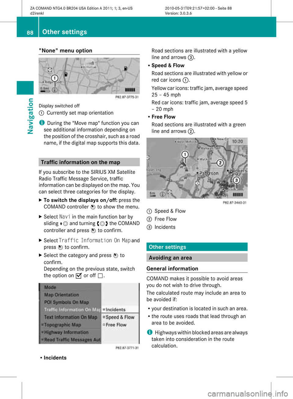
"None"
menuoption Display
switched off
: Currently setmap orientation
i During the"Move map"function youcan
see addi tional information dependingon
the position ofthe crosshair, suchasaroad
name, ifthe digital mapsupports thisdata. Tra
ffic information onthe map
If you subscribe tothe SIRIUS XMSatellite
Rad ioTraffic Message Service,traffic
information canbedispla yedonthe map. You
can select threecategories forthe displa y.
X To switch thedisplays on/off:press the
COMAND controller Wtoshow themenu.
X Select Naviinthe main function barby
slidi ngZV andturning cVdtheCOMAND
cont roller andpress Wtoconfirm.
X Select Traffic Information OnMap and
press Wtoconfirm.
X Select thecategory andpress Wto
confirm.
Depending onthe previous state,switch
the option onO oroff ª. R
Inci dents Road
sections areillustrated withayell ow
line and arrows =.
R Speed &Flow
Road sections areillustr atedwithyellow or
red caricon s:.
Yellow caricon s:traffic jam, average speed
25 –45 mph
Red caricon s:traffic jam, average speed5
– 20 mph
R Free Flow
Road sections areillustr atedwithagreen
line and arrows ;. :
Speed &Flow
; FreeFlow
= Inciden ts Oth
ersett ings Avoiding
anarea
Gener alinfor mation COMA
NDmak esitpossible toavoid areas
you donot wish todrive through.
The calculated routemay include anarea to
be avoided if:
R your destinationislocat edinsuch anarea.
R the rout euses roads thatlead through an
area tobe avoided.
i Highways withinblockedareas arealways
tak enintocon siderat ioninthe rout e
calc ulation . 88
Oth
ersett ingsNavigat ion
ZACOMA NDNTG4. 0BR20 4USA EditionA201 1;1;3,en- US
d2ir enklV ersion:3.0.3.6
2010
-05-31T09 :21:57+0 2:00-Seite 88
Page 94 of 190
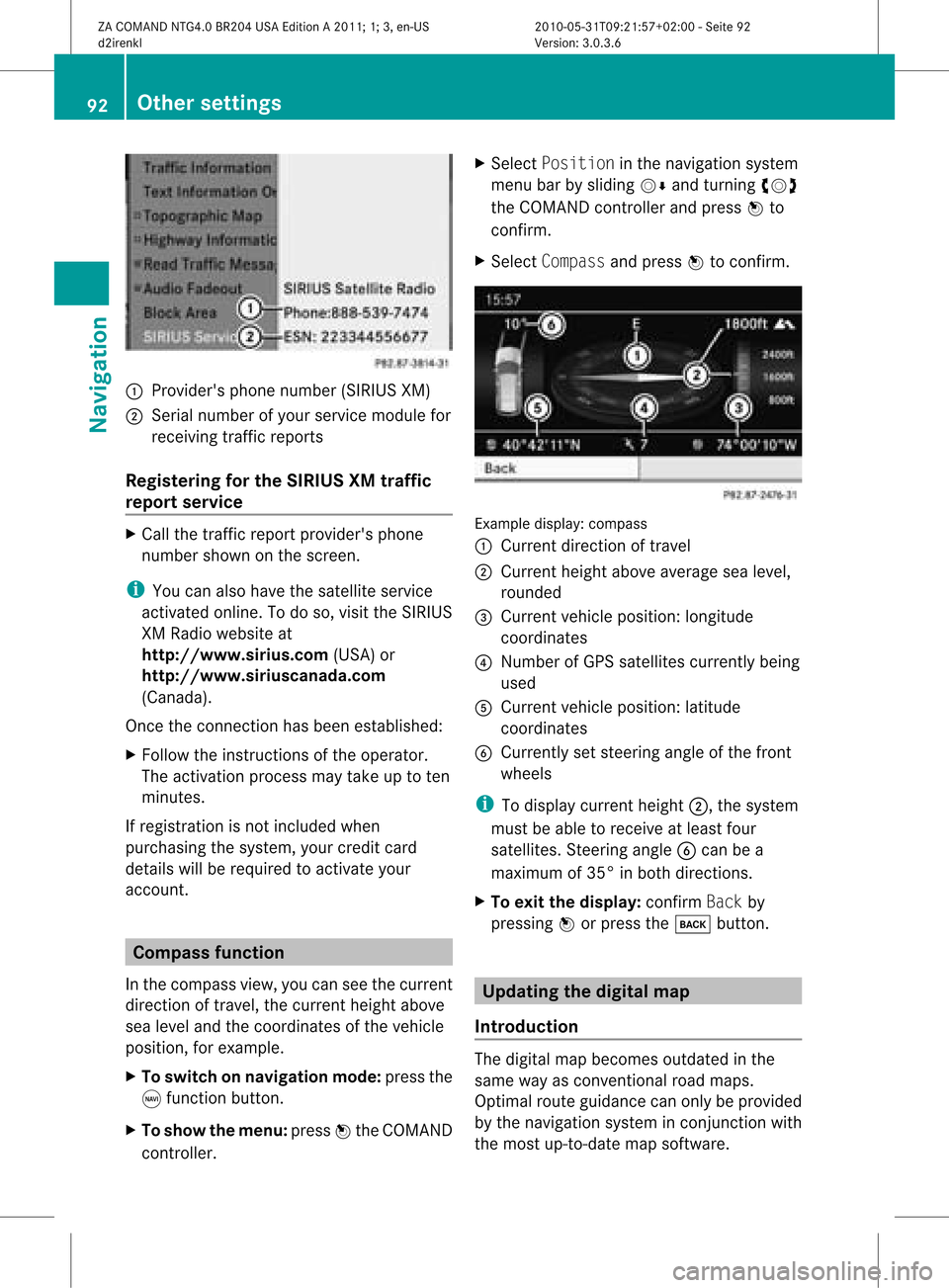
1
Provider's phonenumber (SIRIUSXM)
2 Serial number ofyour service module for
receivin gtraff icreport s
Registering forthe SIRIUS XMtraffic
repor tserv ice X
Call thetraff icrepo rtprov ider' sphon e
num bershown onthesc reen .
i You canalso have thesat ellit eser vice
act ivat edonline .Todo so, visit theSIRIUS
XM Radio website at
htt <0010002D00210021001700170017002000130009001200090015001300200003
000F000DF (USA)or
htt <0010002D00210021001700170017002000130009001200090015001300030001
000E000100040001F .com
(Canada) .
Once theconn ection hasbeen established:
X Follow theinstr uctions ofthe operator.
The activation processmaytake uptoten
minutes.
If registrat ionisnot included when
purchasing thesystem, yourcredit card
details willberequired toactivate your
account . Compass
function
In the compass view,youcan seethecurrent
direction oftravel, thecurrent heightabove
sea level andthecoordinat esofthe vehicle
position, forexample.
X To switch onnavigation mode:pressthe
g funct ionbutton .
X To show themenu: pressWthe COMAND
cont roller. X
Select Position inthe navigation system
menu barbysliding VÆandturnin gcVd
the COMAND controller andpress Wto
conf irm.
X Select Compass andpress Wtoconf irm. Example
display:compass
: Current direction oftravel
; Current heightaboveaverage sealevel,
rounded
= Current vehicleposition: longitude
coordinat es
? Number ofGPS satellites currentlybeing
used
A Current vehicleposition: latitude
coordinat es
B Currently setsteerin gangle ofthe front
wheels
i Todisplay current height;,thesystem
must beable toreceive atleast four
satellites. Steeringangle Bcan bea
maximum of35° inboth direction s.
X To exit thedisplay: confirmBack by
pressing Worpress thek button . Upda
tingthedigital map
Introdu ction The
digital mapbecomes outdatedinthe
same wayasconv ention alroad maps.
Optimal routeguidance canonly beprovided
by the navigation systeminconj unct ionwith
the most up-to- datemapsoftware. 92
Other
settingsNavigation
ZACOMAND NTG4.0BR204USAEdition A2011; 1;3,en-US
d2irenk lV ersion:3.0.3.6
2010
-05-31T09 :21:57+0 2:00-Seite 92
Page 125 of 190

=
Sou ndsetti ngs
? Wea ther Band switche don
A AM radio
B FM radio
C Channe llist
Se archi ngfor achanne l X
Quic kselect: turncVd orslide XVY the
COMA NDcontroller while thed isplay/
selec tionwindow inthe radio display is
act ive.
or
X Press theE orF button.
Chann elsearc hscan sup ordown and
st ops atthe nextchan nelfoun d.
Selecting achanne lfrom thechann el
lis t X
Select Channe lby sliding VÆandturning
cVd theCOMAND controllerand press
W toconfirm.
The channel lista ppears. X
Select achann elby turn ingcVd the
COMAND controller and press Wto
con firm.
or
X Press anumber keyonthe controlpanel,
e.g. 4,atany time. Sat
Rad io Impor
tantnotes
This sectionprovides detailedinformation on
the following topics:
R select ingachann eland program category
R memor yfunc tions
R sound settings
i The satellite radiomode describedbelow
requires optionallyavailable satelliteradio
equipment andregist ration withasatellite
radio provider.
i Note thatthecateg ories andchann els
shown inthe illustration sdepend onthe
program contentoffer edbythe provider.
The program contentsmay vary. The
illustration sand descr iption sin these
operatin ginst ruct ions may therefore differ
from thechann elsand categ ories offered
by the provider.
Satellit eradio mode maybetempo rarily
unavailable orinterrupt edfor avariety of
reasons .These reasons include
environm entalortopographical conditions
as well asother issues beyond thecont rol
of Mercedes-Ben zUSA, LLC.Operation
may alsobeimpaired incertain locations
(e.g. tunnels,parking garages orwithin as
well asclose tobuild ings).
i SIRIUS XMRadi ooffers morethan130
digital-qua lityradio channels providing
100% commerc ial-freemusic,sport,news
and entert ainment.
SIRIUS XMRadi oemploys afleet ofhigh-
performance satellitestobroadcast around
the clock throughout theUSA andCanada .
The satellite radioprogram isavaila blefor
a mont hlyfee. Details areavaila blefrom
the SIRIUS XMService Centerandat
htt <0010002D00210021001700170017002000130009001200090015001300200003
000F000DF (USA)or
htt <0010002D00210021001700170017002000130009001200090015001300030001
000E00010004000100200003000F000DF
(Canada ). SatR
adio
123Audio
ZACOMAND NTG4.0BR204USAEdition A2011; 1;3,en-US
d2irenkl Version:3.0.3.6
2010-
05-31T09:21 :57+02:00-Seite 123