ESP MERCEDES-BENZ CL-Class 2002 C215 Comand Manual
[x] Cancel search | Manufacturer: MERCEDES-BENZ, Model Year: 2002, Model line: CL-Class, Model: MERCEDES-BENZ CL-Class 2002 C215Pages: 251
Page 135 of 251
Telephone
Telephone133
Introduction
AudioTelephone
Navigation
Index Info Services and
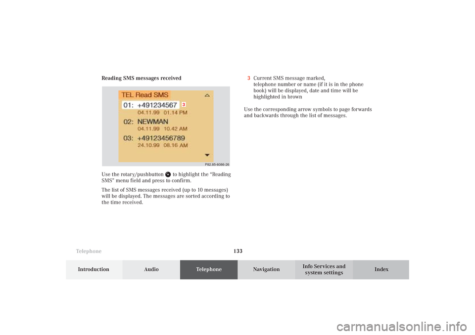
system settings Reading SMS messages received
Use the rotary/pushbutton
to highlight the “Reading
SMS” menu field and press to confirm.
The list of SMS messages received (up to 10 messages)
will be displayed. The messages are sorted according to
the time received.3Current SMS message marked,
telephone number or name (if it is in the phone
book) will be displayed, date and time will be
highlighted in brown
Use the corresponding arrow symbols to page forwards
and backwards through the list of messages.
P82.85-6086-26
3
08-TELEFON-25-US.pm509.07.2004, 14:23 Uhr 133
Page 138 of 251
136 Telephone
AudioTelephoneNavigation
Index Info Services and
system settings Introduction
Emergency call
Important!
If you enter “1” and press the rotary/pushbutton
,
the number stored in memory location 1 (default is
9-1-1) will be dialed.
Pressing or holding “1” longer than 2 seconds will also
initiate the call.
The 9-1-1 emergency call system is a public service.
Using it without due cause is a criminal offense.
You can make an emergency call to an emergency
rescue station with a mobile communications network.The emergency call will be placed as long as the
corresponding mobile communications network is
available. To do this, switch the telephone on, if you
have not already done so.
It will also be placed, if the unlock code is not entered.
Emergency calls may not be possible with all mobile
phone networks or if certain network services and/or
telephone functions are active. Check with your local
network operating company.
Note:
This function places a call to the local 9-1-1 provider. It
does not initiate a Tele Aid call.
08-TELEFON-25-US.pm509.07.2004, 14:24 Uhr 136
Page 147 of 251
145 Destination input
Introduction
Audio
Telephone
Navigation
Index Info Services and
system settings
NotesThe current vehicle position cannot be displayed
exactly in every case. Satellite reception conditions,
road conditions, the condition of the vehicle, etc. could
cause deviations from the actual situation. In this case
enter the current vehicle position manually, page 220.
When the vehicle has been transported by a car train or
a ferry, COMAND will require some time to find its
exact position. In these cases it is often sufficient to
move the vehicle a few yards to receive a complete
route recommendation.
The reception of GPS signals can be unreliable or at
times even impossible:
• When driving between tall buildings, in parking
garages or tunnels, when obstructed by large
vehicles and similar structures
• During electrical storms or very heavy rains
• Satellites may be switched off for checking or repairChanging tires:
We recommend that you have any tire changes done by
a Mercedes-Benz Center. Because COMAND operates
using measurements taken by wheel revolutions, the
tire new size must be entered when the tires are
changed, see calibration on page 221.
Travelling abroad:
If you intend to travel through different regions or
abroad you will need the respective CD. Contact your
Mercedes-Benz Center or the Client Assistance Center
at 1-800-FOR-MERCedes (1-800-367-6372) for the
available CDs.
Remove the actual Navigation CD when you leave a
region or cross the border and insert the Navigation CD
for the region or country you are now in.09-NAVI1-25-US.pm509.07.2004, 14:25 Uhr 145
Page 151 of 251
149 Destination input
Introduction
Audio
Telephone
Navigation
Index Info Services and
system settings
NavigationNote:
When navigation is preparing for operation, various
error messages may appear:
• “Navigation cannot be activated. An error has
occurred.”
• “CD-Reading error. Please change CD” – remove the
current CD and insert the Navigation CD.
• “No CD. Please insert NAVI-CD type DX only” – you
did not insert a CD, insert the Navigation CD type
DX. Please use only a current navigation CD. A
navigation CD from an older model may not be
compatible and may cause an error message to be
displayed.
When the error has been corrected COMAND shows the
message “Activating Navigation. Please obey all traffic
rules”.
To change over to another system press the
corresponding key, e.g.
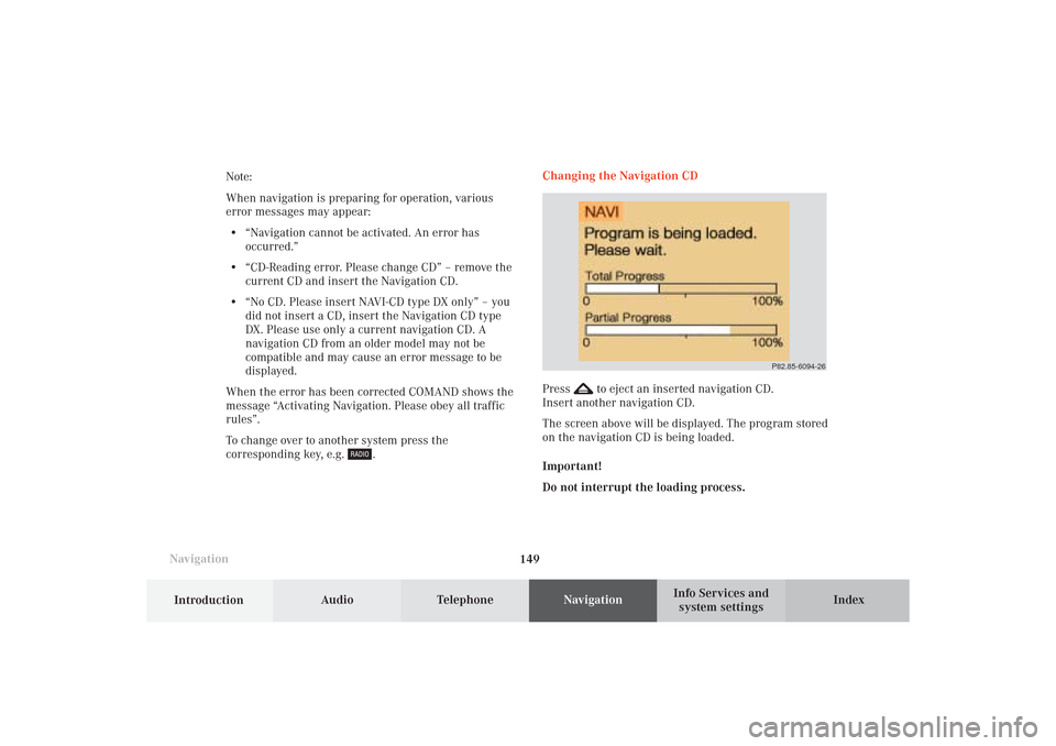
.Changing the Navigation CD
Press
to eject an inserted navigation CD.
Insert another navigation CD.
The screen above will be displayed. The program stored
on the navigation CD is being loaded.
Important!
Do not interrupt the loading process.
P82.85-6094-26
09-NAVI1-25-US.pm509.07.2004, 14:25 Uhr 149
Page 161 of 251
159 Destination input
Introduction
Audio
Telephone
Navigation
Index Info Services and
system settings
P82.85-2600-2624
2526
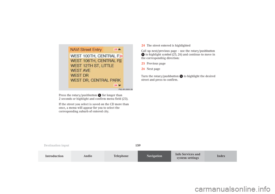
24The street entered is highlighted
Call up next/previous page – use the rotary/pushbutton
to highlight symbol (25, 26) and continue to move in
the corresponding direction:
25Previous page
26Next page
Turn the rotary/pushbutton
to highlight the desired
street and press to confirm.
Press the rotary/pushbutton
for longer than
2 seconds or highlight and confirm menu field (23).
If the street you select is saved on the CD more than
once, a menu will appear for you to select the
corresponding suburb of entered city.
09-NAVI1-25-US.pm509.07.2004, 14:26 Uhr 159
Page 166 of 251
164
Destination input
Audio TelephoneNavigation
Index Info Services and
system settings Introduction
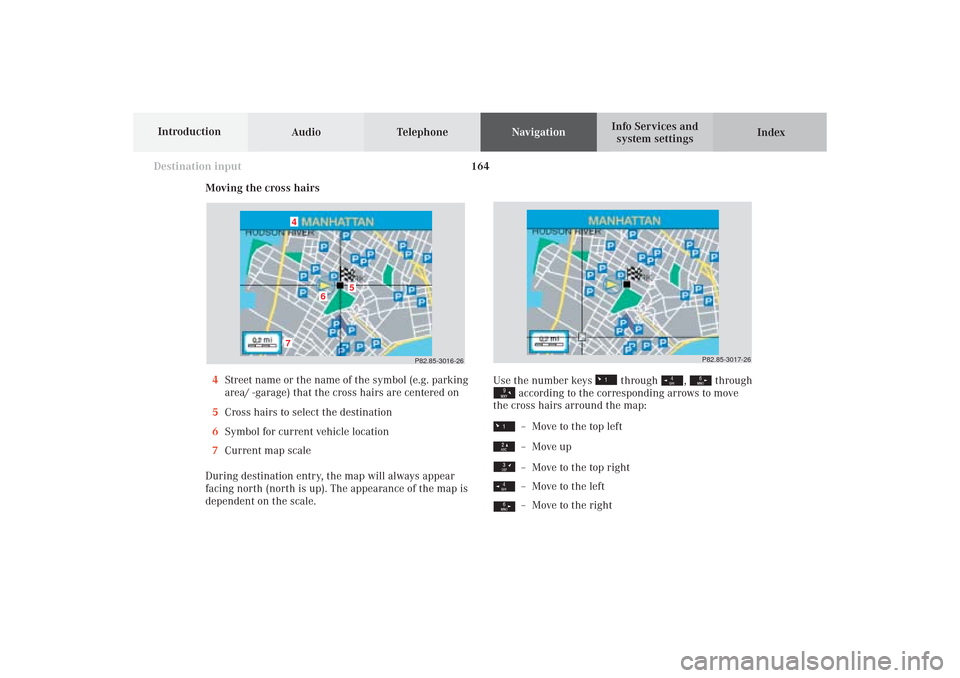
Moving the cross hairs
4Street name or the name of the symbol (e.g. parking
area/ -garage) that the cross hairs are centered on
5Cross hairs to select the destination
6Symbol for current vehicle location
7Current map scale
During destination entry, the map will always appear
facing north (north is up). The appearance of the map is
dependent on the scale.
P82.85-3016-26
7
6
5
4
Use the number keys
through
,
through
according to the corresponding arrows to move
the cross hairs arround the map:– Move to the top left– Move up– Move to the top right– Move to the left– Move to the right
P82.85-3017-26
09-NAVI1-25-US.pm509.07.2004, 14:27 Uhr 164
Page 173 of 251
171 Destination input
Introduction
Audio
Telephone
Navigation
Index Info Services and
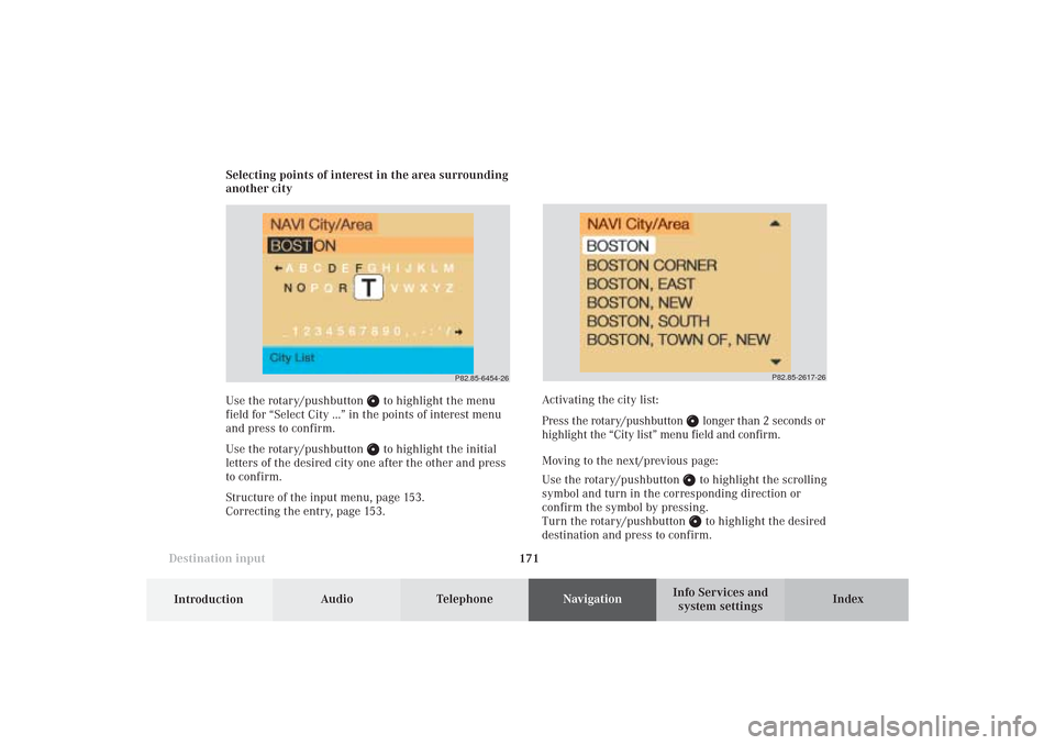
system settings Selecting points of interest in the area surrounding
another city
Use the rotary/pushbutton
to highlight the menu
field for “Select City ...” in the points of interest menu
and press to confirm.
Use the rotary/pushbutton to highlight the initial
letters of the desired city one after the other and press
to confirm.
Structure of the input menu, page 153.
Correcting the entry, page 153.
P82.85-2617-26
Activating the city list:
Press the rotary/pushbutton
longer than 2 seconds or
highlight the “City list” menu field and confirm.
Moving to the next/previous page:
Use the rotary/pushbutton to highlight the scrolling
symbol and turn in the corresponding direction or
confirm the symbol by pressing.
Turn the rotary/pushbutton to highlight the desired
destination and press to confirm.
P82.85-6454-26
09-NAVI1-25-US.pm509.07.2004, 14:27 Uhr 171
Page 175 of 251
173 Destination input
Introduction
Audio
Telephone
Navigation
Index Info Services and
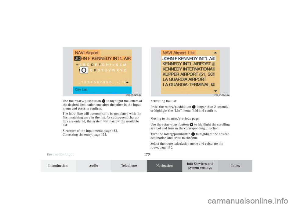
system settings Use the rotary/pushbutton
to highlight the letters of
the desired destination one after the other in the input
menu and press to confirm.
The input line will automatically be populated with the
first matching enry in the list. As subsequent charac-
ters are entered, the system will narrow the available
list.
Structure of the input menu, page 153.
Correcting the entry, page 153.Activating the list:
Press the rotary/pushbutton
longer than 2 seconds
or highlight the “List” menu field and confirm.
Moving to the next/previous page:
Use the rotary/pushbutton to highlight the scrolling
symbol and turn in the corresponding direction.
Turn the rotary/pushbutton to highlight the desired
destination and press to confirm.
Select the route calculation mode and calculate the
route, page 175.
P82.85-6455-26
P82.85-7742-26
09-NAVI1-25-US.pm509.07.2004, 14:28 Uhr 173
Page 182 of 251
Audio TelephoneNavigation
Index Info Services and
system settings Introduction
Route guidance
180
6Selects the destination and route information
screen, page 181
7Marking a way point, page 199
8Mixture of map and symbol display, page 196
9Activates the symbol display
10Selecting map orientation:
North orientation (North-up) or direction of travel
at the top (Heading-up), page 198
11Current map scale
12Symbol for the current vehicle location with
respect to route
13Destination flagRoute guidance is visual with screen displays and
acoustic with voice outputs.
You can select the following screen displays during
route guidance:
• Symbol display - always appears after a route has
been calculated
• Map display - activate the map with menu field (5),
switch back with menu field (9)
• Mix - before the vehicle makes a turn the COMAND
switches automatically to the symbol display, and
the map is displayed again once the turn has been
completed
In the map display, menu fields (6), (7), (9) and (10) are
removed after 15 seconds. Turn the rotary/pushbutton
to display the menu field again.
10-NAVI2-25-US.pm517.10.2001, 10:42 Uhr 180
Page 199 of 251
197
Route guidance
Introduction
Audio Telephone
Navigation
Index Info Services and
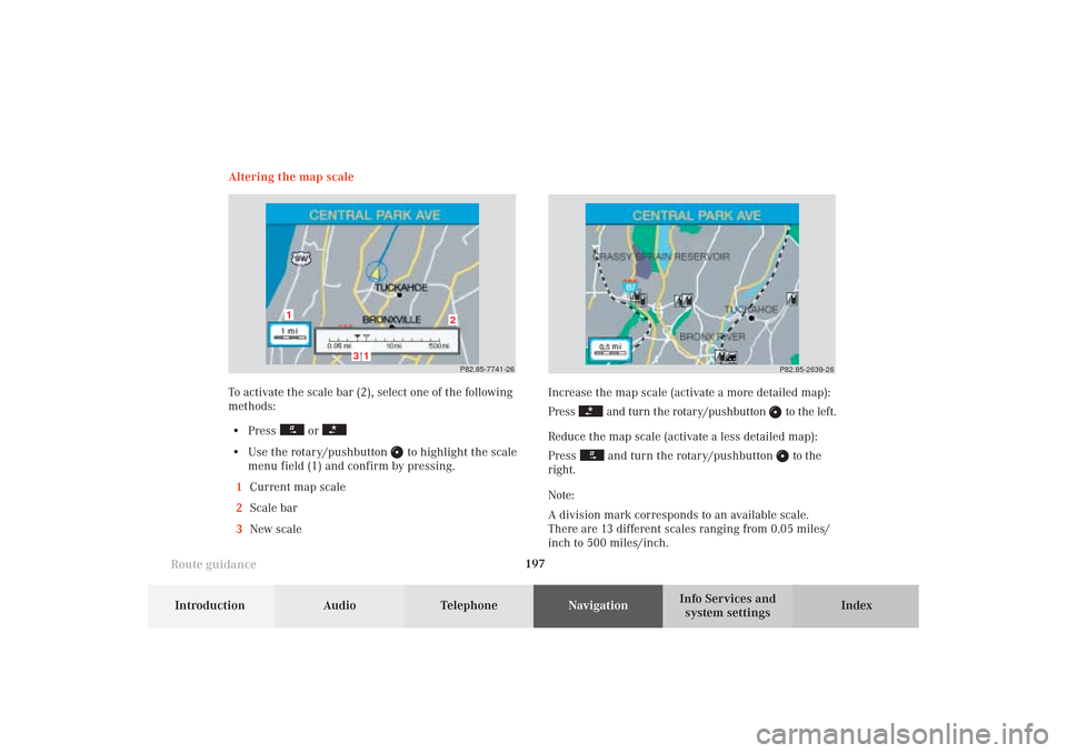
system settings Increase the map scale (activate a more detailed map):
Press
and turn the rotary/pushbutton
to the left.
Reduce the map scale (activate a less detailed map):
Press
and turn the rotary/pushbutton
to the
right.
Note:
A division mark corresponds to an available scale.
There are 13 different scales ranging from 0.05 miles/
inch to 500 miles/inch.P82.85-2639-26
Altering the map scale
To activate the scale bar (2), select one of the following
methods:
• Press
or
• Use the rotary/pushbutton
to highlight the scale
menu field (1) and confirm by pressing.
1Current map scale
2Scale bar
3New scale
P82.85-7741-26
3
2
1
1
10-NAVI2-25-US.pm517.10.2001, 10:42 Uhr 197