display NISSAN MAXIMA 2005 A34 / 6.G Workshop Manual
[x] Cancel search | Manufacturer: NISSAN, Model Year: 2005, Model line: MAXIMA, Model: NISSAN MAXIMA 2005 A34 / 6.GPages: 192, PDF Size: 4.45 MB
Page 76 of 192
![NISSAN MAXIMA 2005 A34 / 6.G Workshop Manual 1. Press the DEST button.
The [DEST. SETTINGS] screen will be
displayed.
Select the
Country key.2. Select the
Country key. Each time the EN-
TER button is pressed, the country selection
toggles betwee NISSAN MAXIMA 2005 A34 / 6.G Workshop Manual 1. Press the DEST button.
The [DEST. SETTINGS] screen will be
displayed.
Select the
Country key.2. Select the
Country key. Each time the EN-
TER button is pressed, the country selection
toggles betwee](/img/5/686/w960_686-75.png)
1. Press the DEST button.
The [DEST. SETTINGS] screen will be
displayed.
Select the
Country key.2. Select the
Country key. Each time the EN-
TER button is pressed, the country selection
toggles between USA and Canada.
3. Then, the selected country will be displayed
at the right of the
Country key.
SETTING WITH THEHome KEY (in
easy mode)
Sets the home as a destination.
INFO:
In the Expert Mode, this key will not be displayed.
Turn on the highlighted amber
Short Menus
key in the [SETTING] screen.1. Press the DEST button.
2. Select the
Home key.
INV2341INV2342INV2316
5-30How do I program a destination?
ZREVIEW COPYÐ2005(nav)
Navigation System OMÐUSA_English(nna)
07/10/04Ðdebbie
X
Page 77 of 192
![NISSAN MAXIMA 2005 A34 / 6.G Workshop Manual 3. The [DEST. SETTING] screen will be
displayed.
Set the
OK key.
To set the destination (waypoints) , refer to “Mak-
ing the system guide the route with detailed op-
tions” on page 5-31.
INFO:
If NISSAN MAXIMA 2005 A34 / 6.G Workshop Manual 3. The [DEST. SETTING] screen will be
displayed.
Set the
OK key.
To set the destination (waypoints) , refer to “Mak-
ing the system guide the route with detailed op-
tions” on page 5-31.
INFO:
If](/img/5/686/w960_686-76.png)
3. The [DEST. SETTING] screen will be
displayed.
Set the
OK key.
To set the destination (waypoints) , refer to “Mak-
ing the system guide the route with detailed op-
tions” on page 5-31.
INFO:
If the home is not registered in the Address
Book, the [STREET ADDRESS] screen will be
displayed.
Please refer to “Setting with the
Street Address key” on page 5-7.
WARNING
To operate the navigation system or to
use the screen functions, first park the
vehicle in a safe place and set the park-
ing brake. Using the system while driv-
ing can distract the driver and may re-
sult in a serious accident.
MAKING THE SYSTEM GUIDE THE
ROUTE WITH DETAILED OPTIONS
By choosing the destination from the menu, you
can choose detailed options such as waypoints
and calculation conditions and have the system
guide you from the current position to the
destination.
Setting the destination
First, you will have to set the destination.
1. Select a destination using one of the meth-
ods described earlier in this chapter:
– Address Book
INV1855INV1191
HAVING THE SYSTEM GUIDE YOU
TO THE DESTINATIONS
How do I program a destination?5-31
ZREVIEW COPYÐ2005(nav)
Navigation System OMÐUSA_English(nna)
07/10/04Ðdebbie
X
Page 78 of 192
– Previous Destination
– Street Address
– Intersection
– Point of Interest (POI)
– City
– Phone Number
– Map
– Home
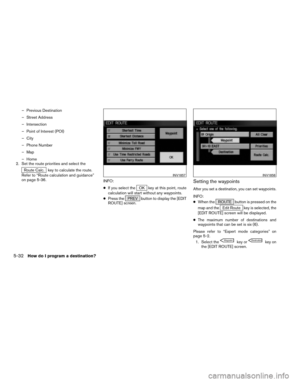
2. Set the route priorities and select the
Route Calc. key to calculate the route.
Refer to “Route calculation and guidance”
on page 5-36.
INFO:
cIf you select the
OK key at this point, route
calculation will start without any waypoints.
cPress the PREV button to display the [EDIT
ROUTE] screen.
Setting the waypoints
After you set a destination, you can set waypoints.
INFO:
cWhen the ROUTE button is pressed on the
map and the
Edit Route key is selected, the
[EDIT ROUTE] screen will be displayed.
cThe maximum number of destinations and
waypoints that can be set is six (6) .
Please refer to “Expert mode categories” on
page 5-2.
1. Select the
key orkey on
the [EDIT ROUTE] screen.
INV1857INV1858
5-32How do I program a destination?
ZREVIEW COPYÐ2005(nav)
Navigation System OMÐUSA_English(nna)
07/10/04Ðdebbie
X
Page 79 of 192
![NISSAN MAXIMA 2005 A34 / 6.G Workshop Manual The [EDIT ROUTE] screen will be displayed.
2. Select a waypoint destination using one of
the destination selection procedures out-
lined earlier in the chapter.Select the conditions with high prioriti NISSAN MAXIMA 2005 A34 / 6.G Workshop Manual The [EDIT ROUTE] screen will be displayed.
2. Select a waypoint destination using one of
the destination selection procedures out-
lined earlier in the chapter.Select the conditions with high prioriti](/img/5/686/w960_686-78.png)
The [EDIT ROUTE] screen will be displayed.
2. Select a waypoint destination using one of
the destination selection procedures out-
lined earlier in the chapter.Select the conditions with high priorities.
If you want to get to your destination in the short-
est time, select the
Shortest Time key.
Selecting the key will turn the indicator light in
the key ON; selecting it again will turn it OFF.
INFO:
cWhen you select the
OK key at this point,
route calculation will start without any addi-
tional waypoints.
cPress the PREV button to display the [EDIT
ROUTE] screen.cIt is also possible to set a waypoint by select-
ing the
Waypoint key in the [DEST. SET-
TING] screen.
Setting the priorities for route calcula-
tion
After the setting of destinations and waypoints is
completed, set the calculation conditions such
as route type with high priorities.
INV2343INV1857
How do I program a destination?5-33
ZREVIEW COPYÐ2005(nav)
Navigation System OMÐUSA_English(nna)
07/10/04Ðdebbie
X
Page 80 of 192

1. Select thePriorities key.
The screen for setting calculation conditions will
appear. The conditions with the indicator light
ON will have high priority.
INFO:
When the ROUTE button is pressed on the
map and the
Edit Route key is selected, the
[EDIT ROUTE] screen will be displayed.2. Select the conditions with high priorities.
Select each key on the screen to turn its re-
spective indicator light ON or OFF.
Shortest Time key:
The route to the destination is calculated so that
you can reach the destination in the shortest
time. In some cases, a freeway or toll road with
detours may be recommended.
NOTE:
It may not be the shortest time in all cases.
Shortest Distance key:
The route to the destination is calculated so that
it is the shortest distance.
NOTE:
It may not be the shortest distance in all
cases.
Minimize Toll Road key:
The route to the destination is calculated with
minimum use of toll roads.
Minimize FWY key:
The route to the destination is calculated with
minimum use of freeways.
Use Time Restricted Roads key:
The route using time restricted roads is
calculated.
INV1860INV1861
5-34How do I program a destination?
ZREVIEW COPYÐ2005(nav)
Navigation System OMÐUSA_English(nna)
07/10/04Ðdebbie
X
Page 81 of 192
NOTE:
If the “Use Time Restricted Roads” is not
selected, the navigation system calculates
a route without including carpool lanes.
The auto reroute function is activated and
recalculates a route including carpool
lanes if both of the following conditions
are met:
cthe auto reroute function is turned ON.
cyou deviate from suggested road and
drive on a carpool lane. With this auto
reroute calculation, a suggested route
including carpool lanes will be
displayed, and the message “The route
has changed to include time restricted
roads. Please be sure to obey traffic
regulations.” will be displayed on the
screen. Because the suggested route
provided at this time is calculated with-
out taking regulations and limitations of
time restricted roads into consideration
at all, please drive safely and follow the
actual roads and regulations when
driving.
NOTE:
When driving on a time restricted road, be
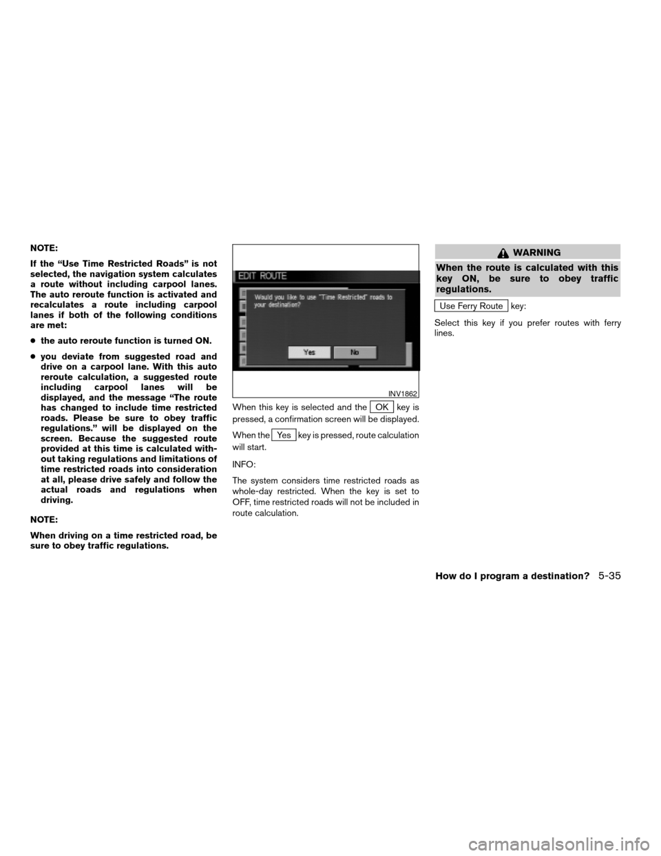
sure to obey traffic regulations.When this key is selected and the
OK key is
pressed, a confirmation screen will be displayed.
When the
Yes key is pressed, route calculation
will start.
INFO:
The system considers time restricted roads as
whole-day restricted. When the key is set to
OFF, time restricted roads will not be included in
route calculation.
WARNING
When the route is calculated with this
key ON, be sure to obey traffic
regulations.
Use Ferry Route key:
Select this key if you prefer routes with ferry
lines.
INV1862
How do I program a destination?5-35
ZREVIEW COPYÐ2005(nav)
Navigation System OMÐUSA_English(nna)
07/22/04Ðmarlene
X
Page 82 of 192
Route calculation and guidance
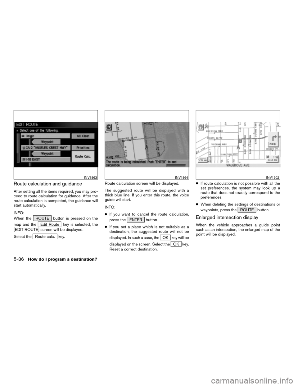
After setting all the items required, you may pro-
ceed to route calculation for guidance. After the
route calculation is completed, the guidance will
start automatically.
INFO:
When the ROUTE button is pressed on the
map and the
Edit Route key is selected, the
[EDIT ROUTE] screen will be displayed.
Select the
Route calc. key.Route calculation screen will be displayed.
The suggested route will be displayed with a
thick blue line. If you enter this route, the voice
guide will start.
INFO:
cIf you want to cancel the route calculation,
press the ENTER button.
cIf you set a place which is not suitable as a
destination, the suggested route will not be
displayed. In such a case, theOK key will be
displayed on the screen. Select the
OK key.
Reset a correct destination.cIf route calculation is not possible with all the
set preferences, the system may look up a
route that does not exactly correspond to the
preferences.
cWhen deleting the settings of destinations or
waypoints, press the ROUTE button.
Enlarged intersection display
When the vehicle approaches a guide point
such as an intersection, the enlarged map of the
point will be displayed.
INV1863INV1864INV1302
5-36How do I program a destination?
ZREVIEW COPYÐ2005(nav)
Navigation System OMÐUSA_English(nna)
07/10/04Ðdebbie
X
Page 83 of 192
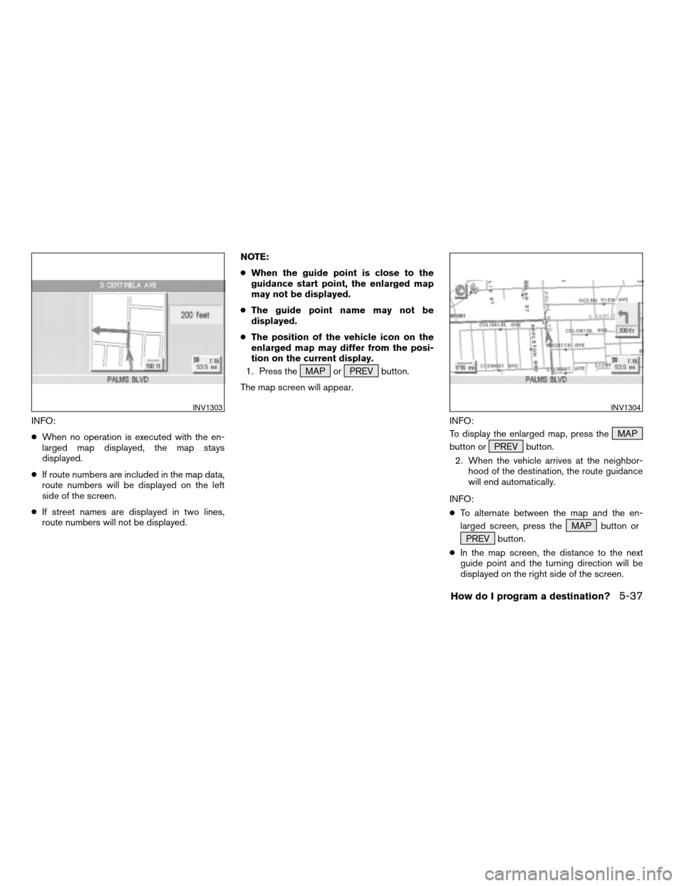
INFO:
cWhen no operation is executed with the en-
larged map displayed, the map stays
displayed.
cIf route numbers are included in the map data,
route numbers will be displayed on the left
side of the screen.
cIf street names are displayed in two lines,
route numbers will not be displayed.NOTE:
cWhen the guide point is close to the
guidance start point, the enlarged map
may not be displayed.
cThe guide point name may not be
displayed.
cThe position of the vehicle icon on the
enlarged map may differ from the posi-
tion on the current display.
1. Press the MAP or PREV button.
The map screen will appear.
INFO:
To display the enlarged map, press the MAP
button or PREV button.
2. When the vehicle arrives at the neighbor-
hood of the destination, the route guidance
will end automatically.
INFO:
cTo alternate between the map and the en-
larged screen, press the MAP button or
PREV button.
cIn the map screen, the distance to the next
guide point and the turning direction will be
displayed on the right side of the screen.
INV1303INV1304
How do I program a destination?5-37
ZREVIEW COPYÐ2005(nav)
Navigation System OMÐUSA_English(nna)
07/10/04Ðdebbie
X
Page 85 of 192
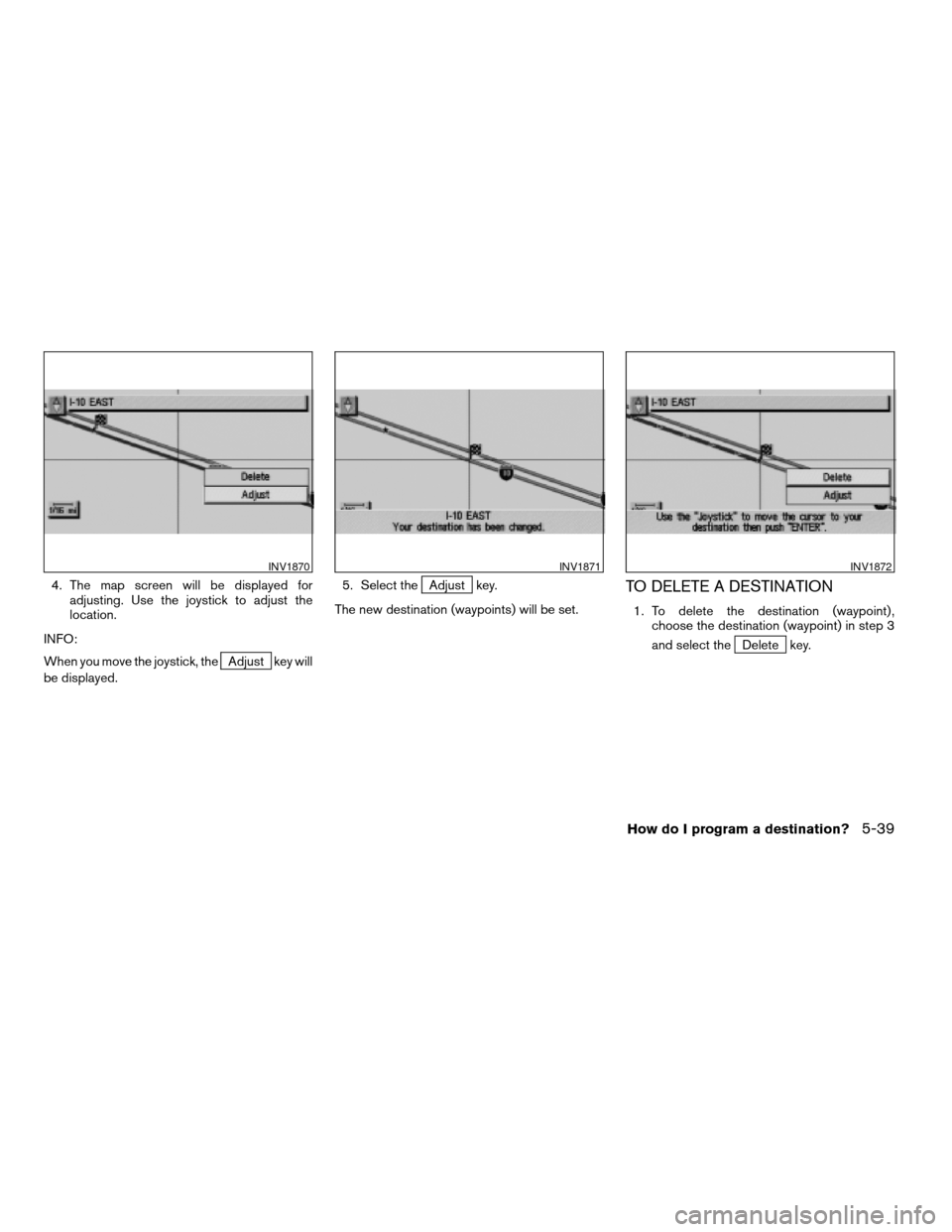
4. The map screen will be displayed for
adjusting. Use the joystick to adjust the
location.
INFO:
When you move the joystick, the
Adjust key will
be displayed.5. Select the
Adjust key.
The new destination (waypoints) will be set.TO DELETE A DESTINATION
1. To delete the destination (waypoint) ,
choose the destination (waypoint) in step 3
and select the
Delete key.
INV1870INV1871INV1872
How do I program a destination?5-39
ZREVIEW COPYÐ2005(nav)
Navigation System OMÐUSA_English(nna)
07/10/04Ðdebbie
X
Page 86 of 192
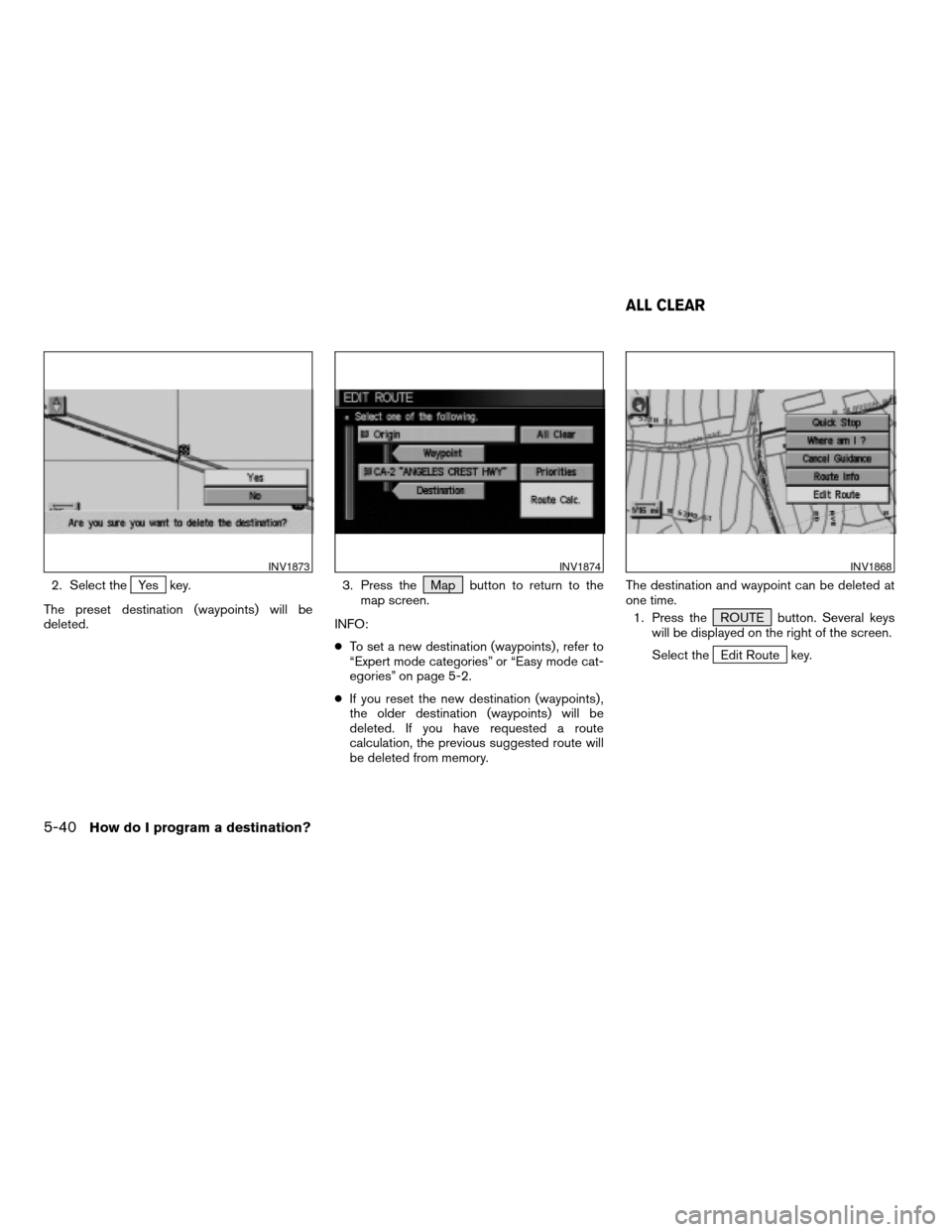
2. Select theYes key.
The preset destination (waypoints) will be
deleted.3. Press the Map button to return to the
map screen.
INFO:
cTo set a new destination (waypoints) , refer to
“Expert mode categories” or “Easy mode cat-
egories” on page 5-2.
cIf you reset the new destination (waypoints) ,
the older destination (waypoints) will be
deleted. If you have requested a route
calculation, the previous suggested route will
be deleted from memory.The destination and waypoint can be deleted at
one time.
1. Press the ROUTE button. Several keys
will be displayed on the right of the screen.
Select the
Edit Route key.
INV1873INV1874INV1868
ALL CLEAR
5-40How do I program a destination?
ZREVIEW COPYÐ2005(nav)
Navigation System OMÐUSA_English(nna)
07/10/04Ðdebbie
X