change time NISSAN PATHFINDER 2012 R52 / 4.G 06IT Navigation Manual
[x] Cancel search | Manufacturer: NISSAN, Model Year: 2012, Model line: PATHFINDER, Model: NISSAN PATHFINDER 2012 R52 / 4.GPages: 235, PDF Size: 5.14 MB
Page 2 of 235

NISSAN NAVIGATION SYSTEM HELP-
DESK CONTACT INFORMATION
For assistance or inquiries about the NISSAN
Navigation System or to order updated map
data, contact the NISSAN NAVIGATION SYS-
TEM HELPDESK at:
.ADDRESS: P.O. Box 1588,
Orem, UT 84059-992
.
.
PHONE: 1-888-661-9995
. HOURS: 6:00 AM to 5:00 PM
(Pacific Time)
NISSAN CONSUMER AFFAIRS DE-
PARTMENT
For assistance or inquiries about the NISSAN
warranty, service or general questions, contact
the NISSAN Consumer Affairs Department at:
For U.S. customers
Nissan North America, Inc.
Consumer Affairs Department
P.O. Box 685003
Franklin, TN 37068-5003
1-800-NISSAN-1
(1-800-647-7261)
For Canadian customers
Nissan Canada Inc.
5290 Orbitor Drive
Mississauga, Ontario L4W 4Z5
1-800-387-0122 Thank you for purchasing a NISSAN vehicle.
This user’s manual is for the navigation system
only. This manual contains operating instructions
for the NISSAN Navigation System offered in
your NISSAN vehicle.
Please read this manual carefully to ensure safe
operation of the navigation system.
.
Because of possible specification changes
and optional equipment, sections of this
manual may not apply to your vehicle.
. All information, specifications and illustra-
tions in this manual are those in effect at the
time of printing. NISSAN reserves the right
to change specifications or design at any
time without notice.
. Do not remove this manual from the vehicle
when selling this vehicle. The next user of
this navigation system may need the manual.
FOREWORD
WEB SITE: www.NissanNavigation.com
. or
www. issan.c
E-MAIL: [email protected]
na
Page 49 of 235
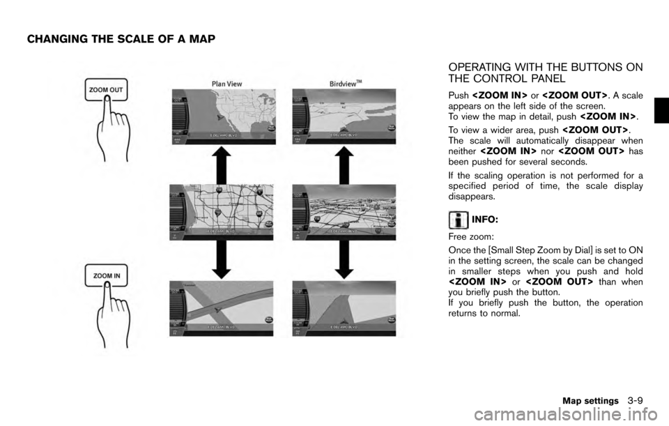
OPERATING WITH THE BUTTONS ON
THE CONTROL PANEL
Push
appears on the left side of the screen.
To view the map in detail, push
To view a wider area, push
The scale will automatically disappear when
neither
been pushed for several seconds.
If the scaling operation is not performed for a
specified period of time, the scale display
disappears.
INFO:
Free zoom:
Once the [Small Step Zoom by Dial] is set to ON
in the setting screen, the scale can be changed
in smaller steps when you push and hold
you briefly push the button.
If you briefly push the button, the operation
returns to normal.
CHANGING THE SCALE OF A MAP
Map settings3-9
Page 98 of 235
.Route Settings:
Allows you to change the route calculation
conditions anywhere along the route.
“SETTING CONDITIONS FOR THE
ROUTE CALCULATION” (page 5-13)
. Recalculate:
You can manually search for the route again
after changing the search condition.
“RECALCULATE ROUTE” (page 5-
16)
. Detour:
If you want to detour from the suggested
route, you can calculate a route detouring for
a specified distance.
“SETTING A DETOUR ROUTE”
(page 5-17)
. Guidance Settings:
You can set various guidance information to
be displayed during route guidance and
activate or deactivate route and/or voice
guidance.
“ROUTE GUIDANCE SETTINGS”
(page 5-17)
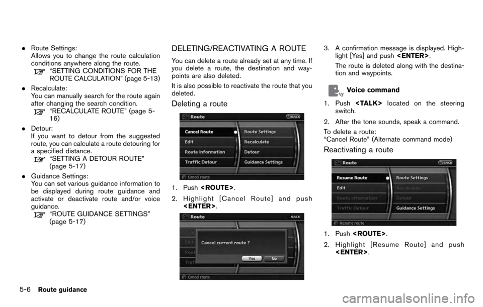
DELETING/REACTIVATING A ROUTE
You can delete a route already set at any time. If
you delete a route, the destination and way-
points are also deleted.
It is also possible to reactivate the route that you
deleted.
Deleting a route
1. Push
2. Highlight [Cancel Route] and push
3. A confirmation message is displayed. High-
light [Yes] and push
The route is deleted along with the destina-
tion and waypoints.
Voice command
1. Push
switch.
2. After the tone sounds, speak a command.
To delete a route:
“Cancel Route” (Alternate command mode)
Reactivating a route
1. Push
2. Highlight [Resume Route] and push
5-6Route guidance
Page 104 of 235
![NISSAN PATHFINDER 2012 R52 / 4.G 06IT Navigation Manual While the map scale is being changed, the route
preview is temporarily stopped.
Confirming by simulation
1. Highlight [Simulation] and press<ENTER>.
2. Highlight the preferred key and push <ENTER> .
: NISSAN PATHFINDER 2012 R52 / 4.G 06IT Navigation Manual While the map scale is being changed, the route
preview is temporarily stopped.
Confirming by simulation
1. Highlight [Simulation] and press<ENTER>.
2. Highlight the preferred key and push <ENTER> .
:](/img/5/280/w960_280-103.png)
While the map scale is being changed, the route
preview is temporarily stopped.
Confirming by simulation
1. Highlight [Simulation] and press
2. Highlight the preferred key and push
: Pauses the simulation.
: Resumes the simulation.
: Ends the simulation.
3. Push
Page 105 of 235
.If you do not select the detour route and
provide no further action, the detour route
will be automatically cancelled.
. You can try to retrieve the detour suggestion
even after the message disappears by
manually selecting “Traffic Detour”. The
system will then search for the detour again
and suggest a detour if one is available at
that time.
. If you have not subscribed to XM NavTraf-
fic
®, it will not be possible to get a traffic
detour or apply settings for traffic informa-
tion related functions. A message appears
when a related menu item is selected.
. See “NOTES ON TRAFFIC INFORMA-
TION” for further information.
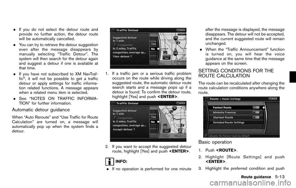
Automatic detour guidance
When “Auto Reroute” and “Use Traffic for Route
Calculation” are turned on, a message will
automatically pop up when the system finds a
detour.
1. If a traffic jam or a serious traffic problem
occurs on the route while driving along the
suggested route, the automatic detour route
search starts and a message pops up if a
detour is found. To confirm the detour route,
highlight [Yes] and push
2. If you want to accept the suggested detour
route, highlight [Yes] and push
INFO:
. If no operation is performed for one minute after the message is displayed, the message
disappears. The detour will not be accepted,
and the current suggested route will remain
unchanged.
. When the “Traffic Announcement” function
is turned on, you will hear the voice
guidance at the same time that the message
appears on the screen.
SETTING CONDITIONS FOR THE
ROUTE CALCULATION
The route can be recalculated after changing the
route calculation conditions anywhere along the
route.
Basic operation
1. Push
2. Highlight [Route Settings] and push
3. Highlight the preferred condition and push
Route guidance5-13
Page 106 of 235
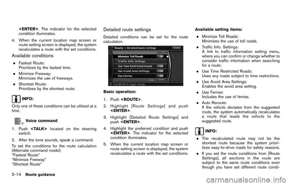
condition illuminates.
4. When the current location map screen or route setting screen is displayed, the system
recalculates a route with the set conditions.
Available conditions
.Fastest Route:
Prioritizes by the fastest time.
. Minimize Freeway:
Minimizes the use of freeways.
. Shortest Route:
Prioritizes by the shortest route.
INFO:
Only one of these conditions can be utilized at a
time.
Voice command
1. Push
switch.
2. After the tone sounds, speak a command.
To set the conditions for the route calculation
(Alternate command mode):
“Fastest Route”
“Minimize Freeway”
“Shortest Route”
Detailed route settings
Detailed conditions can be set for the route
calculation.
Basic operation:
1. Push
2. Highlight [Route Settings] and push
3. Highlight [Detailed Route Settings] and push
4. Highlight the preferred condition and push
condition illuminates.
5. When the current location map screen or route setting screen is displayed, the system
recalculates a route with the set conditions. Available setting items:
. Minimize Toll Roads:
Minimizes the use of toll roads.
. Traffic Info. Settings:
A link to traffic information setting menu,
where you can confirm or change whether to
consider traffic information when searching
for a route.
. Use Time Restricted Roads:
Uses any roads subject to time restrictions.
. Use Avoid Area Settings:
Enables the avoid area setting.
. Use Ferries:
Includes the use of ferries.
. Auto Reroute:
If the vehicle deviates from the suggested
route, the system automatically recalculates
a route that leads the vehicle to the
suggested route.
INFO:
. The recalculated route may not be the
shortest route because the system priori-
tizes easy-to-drive roads for safety reasons.
. If you set the route conditions from [Route
Settings], all sections in the route are
subject to the same route conditions even
though you have set different route condi-
5-14Route guidance
Page 107 of 235
![NISSAN PATHFINDER 2012 R52 / 4.G 06IT Navigation Manual tions for different sections in [Edit].
. If [Use Time Restricted Roads] is deacti-
vated, the system calculates a route without
any consideration of the regulations con-
cerning the time or day of th NISSAN PATHFINDER 2012 R52 / 4.G 06IT Navigation Manual tions for different sections in [Edit].
. If [Use Time Restricted Roads] is deacti-
vated, the system calculates a route without
any consideration of the regulations con-
cerning the time or day of th](/img/5/280/w960_280-106.png)
tions for different sections in [Edit].
. If [Use Time Restricted Roads] is deacti-
vated, the system calculates a route without
any consideration of the regulations con-
cerning the time or day of the week. There-
fore, the suggested route may include a road
subject to traffic regulations concerning the
time or day of the week. When driving along
the route, always follow all traffic regulations
regardless of whether [Use Time Restricted
Roads] is ON or OFF.
. If the system cannot calculate any alternative
routes, it displays the previous route.
. If the vehicle overly deviates from the
suggested route, the system calculates a
new route.
Traffic Information Settings
Allows you to confirm or change the settings for
the traffic information related functions.
Basic operation:
1. Push
2. Highlight [Route Settings] and push
3. Highlight [Detailed Route Settings] and push
4. Highlight [Traffic Info. Settings] and push
5. Highlight the preferred condition and push
condition illuminates.
6. When the current location map screen or route setting screen is displayed, the system
recalculates a route with the set conditions.
Available setting items: . Use Traffic Info.:
Enables all traffic information related func-
tions.
. Show Traffic Flow on Map:
Displays the traffic flow with an arrow on the
map screen.
. Show Incidents on Map:
Displays the traffic incidents (e.g., accident)
on the map screen.
. Blink Red Traffic Flow:
Blinks the red traffic flow lines that represent congestions.
. Use Traffic for Travel Time:
Calculates the estimated travel time to
destination taking traffic flow into considera-
tion.
. Use Traffic for Route Calculation:
Allows you to perform the route search with
the traffic information taken into considera-
tion.
When “Auto Reroute” is set, the detour
route search can be performed automati-
cally.
. Traffic Announcements:
This can provide you with the announcement
of the traffic information event on the route.
INFO:
. An XM NavTraffic
®subscription is required
in order to receive Traffic Information.
. Even when “Show Traffic Flow On Map” and
“Show Incidents on Map” are set to off, the
list display of “Info On Route” and “Nearby
Traffic Info” will not be affected.
. Even when “Traffic Announcements” is set
to off, the route guidance will not be
affected. Also, the announcement of emer-
gency information will not be turned off.
Route guidance5-15
Page 114 of 235
![NISSAN PATHFINDER 2012 R52 / 4.G 06IT Navigation Manual Set average speeds
You can calculate the required time to the
destination based on the set vehicle speeds.
Basic operation:
1. Push<ROUTE> .
2. Highlight [Guidance Settings] and push <ENTER> .
3. High NISSAN PATHFINDER 2012 R52 / 4.G 06IT Navigation Manual Set average speeds
You can calculate the required time to the
destination based on the set vehicle speeds.
Basic operation:
1. Push<ROUTE> .
2. Highlight [Guidance Settings] and push <ENTER> .
3. High](/img/5/280/w960_280-113.png)
Set average speeds
You can calculate the required time to the
destination based on the set vehicle speeds.
Basic operation:
1. Push
2. Highlight [Guidance Settings] and push
3. Highlight [Set Average Speeds] and push
4. Highlight the preferred item and push
5. Use the main directional buttons or the center dial to make an adjustment. The
speed can be increased/decreased by 5
MPH (5 km/h) .
6. After finishing the setting, push
or
screen. Push
Page 145 of 235
XM NavTraffic®information is a subscription
service offered by XM®Satellite Radio.
This service provides real-time information
regarding traffic flow, accidents, road construc-
tion and other incidents, where available.
XM NavTraffic
®combines information from
commercial and public traffic data providers
including government departments of transpor-
tation, police, emergency services, road sen-
sors, cameras and aircraft reports. The traffic
information is broadcast to the vehicle by the
XM
®satellites. Available traffic information on
the route the driver selected is shown on the
navigation screen so traffic conditions between
you and the destination are known. Three types
of real-time traffic information for major road-
ways are shown on the navigation system:
* Unscheduled traffic data for example, acci-
dents and disabled vehicles.
* Scheduled traffic data, for example road
construction and road closures.
* Traffic flow information (rate of speed data) .
WARNING
XM NavTraffic®information is not a
substitute for attentive driving. Traffic
conditions change constantly and emergency situations can arise with-
out warning. Relying only on XM
NavTraffic
®information may lead to
a collision and could result in serious
personal injury.
NOTE:
Flow information is provided only for
roads equipped with traffic sensors and
is not available in all markets covered by
the service. Flow data may not be available
on portions of a road that is under
construction.
XM NavTraffic
®information is available in limited
markets. To subscribe or to check if this service
is available in your area:
call 1-800-XM-RADIO (1-800-967-2346) or
see www.xmradio.com/navtraffic
INFO:
If you do not have a contract for XM NavTraffic
®
traffic information service, a message appears,
and it will not be possible to check the
information on the traffic information system.
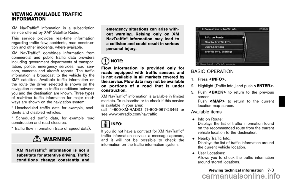
BASIC OPERATION
1. Press
2. Highlight [Traffic Info.] and push
3. Push
screen.
Push
Page 155 of 235
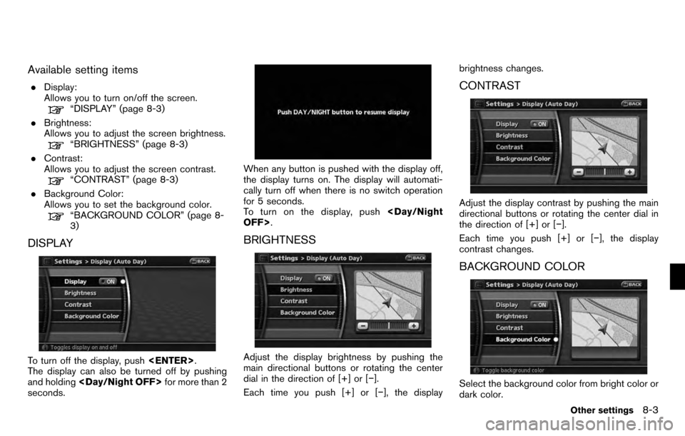
Available setting items
.Display:
Allows you to turn on/off the screen.
“DISPLAY” (page 8-3)
. Brightness:
Allows you to adjust the screen brightness.
“BRIGHTNESS” (page 8-3)
. Contrast:
Allows you to adjust the screen contrast.
“CONTRAST” (page 8-3)
. Background Color:
Allows you to set the background color.
“BACKGROUND COLOR” (page 8-
3)
DISPLAY
To turn off the display, push
The display can also be turned off by pushing
and holding
seconds.
When any button is pushed with the display off,
the display turns on. The display will automati-
cally turn off when there is no switch operation
for 5 seconds.
To turn on the display, push
BRIGHTNESS
Adjust the display brightness by pushing the
main directional buttons or rotating the center
dial in the direction of [+] or [−].
Each time you push [+] or [− ], the displaybrightness changes.
CONTRAST
Adjust the display contrast by pushing the main
directional buttons or rotating the center dial in
the direction of [+] or [−
].
Each time you push [+] or [− ], the display
contrast changes.
BACKGROUND COLOR
Select the background color from bright color or
dark color.
Other settings8-3