radio NISSAN QUEST 2016 RE52 / 4.G 08IT Navigation Manual
[x] Cancel search | Manufacturer: NISSAN, Model Year: 2016, Model line: QUEST, Model: NISSAN QUEST 2016 RE52 / 4.GPages: 241, PDF Size: 4.34 MB
Page 7 of 241
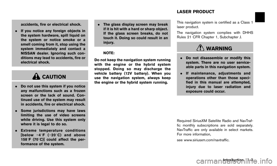
accidents, fire or electrical shock.
. If you notice any foreign objects in
the system hardware, spill liquid on
the system or notice smoke or a
smell coming from it, stop using the
system immediately and contact a
NISSAN dealer. Ignoring such con-
ditions may lead to accidents, fire or
electrical shock.
CAUTION
.Do not use this system if you notice
any malfunctions such as a frozen
screen or the lack of sound. Con-
tinued use of the system may result
in accidents, fire or electrical shock.
. Some jurisdictions may have laws
limiting the use of video screens
while driving. Use this system only
where it is legal to do so.
. Extreme temperature conditions
[below �í48F( �í208 C) and above
1588F (708C)] could affect the per-
formance of the system. .
The glass display screen may break
if it is hit with a hard or sharp object.
If the glass screen breaks, do not
touch it. Doing so could result in an
injury.
NOTE:
Do not keep the navigation system running
with the engine or the hybrid system
stopped. Doing so may discharge the
vehicle battery (12V battery) . When you
use the navigation system, always keep
the engine or the hybrid system running. This navigation system is certified as a Class 1
laser product.
The navigation system complies with DHHS
Rules 21 CFR Chapter 1, Subchapter J.WARNING
.
Do not disassemble or modify this
system. There are no user service-
able parts in this navigation system.
. If maintenance, adjustments and
operations other than those speci-
fied in this manual are attempted,
injury due to laser radiation and
exposure could occur.
Required SiriusXM Satellite Radio and NavTraf-
fic monthly subscriptions are sold separately.
NavTraffic are only available in select markets.
For more information,
see www.siriusxm.com/navtraffic.
Introduction1-3
LASER PRODUCT
Page 8 of 241
1-4Introduction
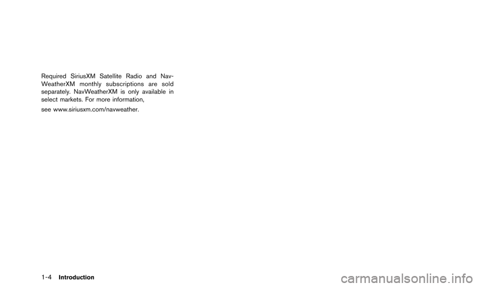
Required SiriusXM Satellite Radio and Nav-
WeatherXM monthly subscriptions are sold
separately. NavWeatherXM is only available in
select markets. For more information,
see www.siriusxm.com/navweather.
Page 35 of 241
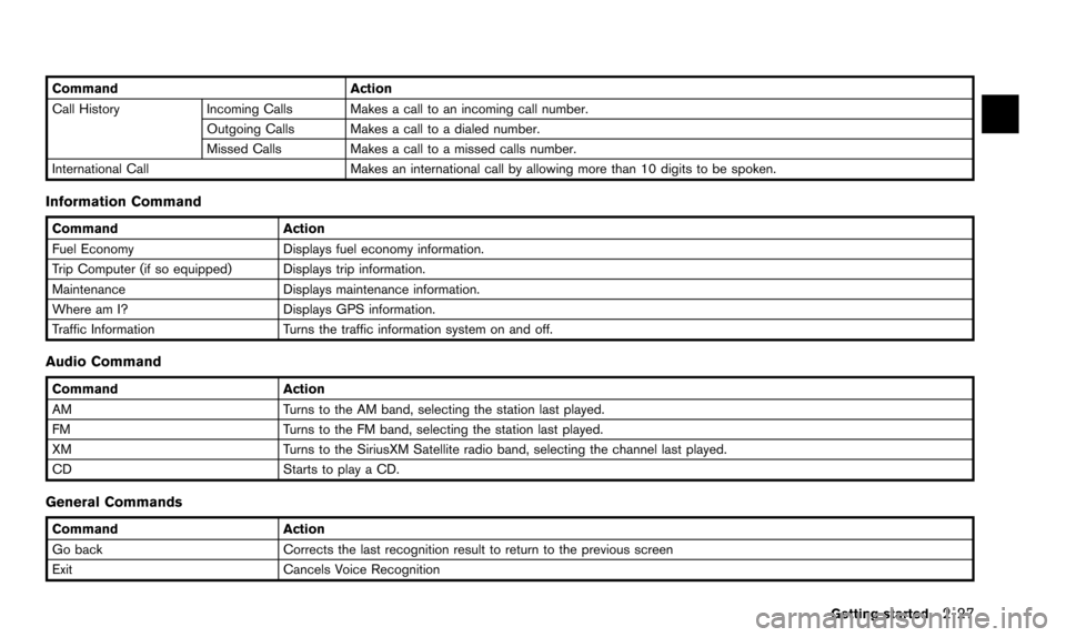
CommandAction
Call History Incoming Calls Makes a call to an incoming call number.
Outgoing Calls Makes a call to a dialed number.
Missed CallsMakes a call to a missed calls number.
International Call Makes an international call by allowing more than 10 digits to be spoken.
Information Command
CommandAction
Fuel Economy Displays fuel economy information.
Trip Computer (if so equipped) Displays trip information.
Maintenance Displays maintenance information.
Where am I? Displays GPS information.
Traffic Information Turns the traffic information system on and off.
Audio Command
CommandAction
AM Turns to the AM band, selecting the station last played.
FM Turns to the FM band, selecting the station last played.
XM Turns to the SiriusXM Satellite radio band, selecting the channel last played.
CD Starts to play a CD.
General Commands
Command Action
Go back Corrects the last recognition result to return to the previous screen
Exit Cancels Voice Recognition
Getting started
2-27
Page 139 of 241
![NISSAN QUEST 2016 RE52 / 4.G 08IT Navigation Manual This displays the information about the vehicle
location on the route when driving according to
route guidance.
BASIC OPERATION
1. Push<INFO>.
2. Highlight [Where am I?] and push <ENTER>.
3. Push <BAC NISSAN QUEST 2016 RE52 / 4.G 08IT Navigation Manual This displays the information about the vehicle
location on the route when driving according to
route guidance.
BASIC OPERATION
1. Push<INFO>.
2. Highlight [Where am I?] and push <ENTER>.
3. Push <BAC](/img/5/457/w960_457-138.png)
This displays the information about the vehicle
location on the route when driving according to
route guidance.
BASIC OPERATION
1. Push
2. Highlight [Where am I?] and push
3. Push
screen. Push
Page 144 of 241
![NISSAN QUEST 2016 RE52 / 4.G 08IT Navigation Manual 7-8Viewing technical information
4. Highlight the preferred setting and push<ENTER>. The indicator for the selected
setting illuminates.
Available setting items
.[Use Traffic Info]:
Enables all traffi NISSAN QUEST 2016 RE52 / 4.G 08IT Navigation Manual 7-8Viewing technical information
4. Highlight the preferred setting and push<ENTER>. The indicator for the selected
setting illuminates.
Available setting items
.[Use Traffic Info]:
Enables all traffi](/img/5/457/w960_457-143.png)
7-8Viewing technical information
4. Highlight the preferred setting and push
setting illuminates.
Available setting items
.[Use Traffic Info]:
Enables all traffic information related func-
tions.
. [Show Incidents on Map]:
Displays the traffic incidents (e.g., accident)
on the map screen.
. [Show Traffic Flow on Map]:
Displays the traffic flow with an arrow on the
map screen.
. [Blink Red Traffic Flow]:
Blinks the red traffic flow lines that represent
congestions.
. [Traffic Announcement]:
Announces the traffic information event on the route.
INFO:
. Even when [Show Traffic Flow on Map] and
[Show Incidents on Map] are set to off, the
list display of [Info on Route] and [Nearby
Traffic Info] will not be affected.
. Even when [Traffic Announcement] is set to
off, the route guidance will not be affected.
Also, the announcement of emergency
information and weather information will not
be turned off.
Voice command
1. Push
wheel switch.
2. After the tone sounds, speak a command.
To turn on or off the traffic information system:
“Information” “Traffic Information” (Standard
mode)
“Traffic Information” (Alternate command mode) NavWeatherXM information is a subscription
service offered by SiriusXM Satellite Radio.
This service provides real-time information
regarding current weather, temperature, warn-
ings, road conditions and forecasts where
available. The weather information is broadcast
to the vehicle by the SiriusXM Satellite Radio.
The service enables you to view the following
information on the navigation system.
. Current weather information icon of the
destination on the screen of suggested
route
. Detailed weather information and forecasts
of an area of interest
. Countrywide and local maps with the
current weather, temperature, warnings and
road condition information
. List of warning/watches events detected
around the current location
. Pop-up messages on the navigation screen
with voice announcements when warnings
and watches are detected around the
current location
VIEWING AVAILABLE WEATHER
INFORMATION
Page 152 of 241
7-16Viewing technical information
The message includes the weather icon and text
describing the event.
INFO:
. The pop-up messages and announcements
can be set to on or off.
“Weather information settings”
(page 7-16)
. If multiple warning/watch events are de-
tected, they will be displayed in order
starting with the one having the shortest
linear distance from the vehicle.
Weather information settings
The settings can be confirmed and changed for
the urgent weather information related functions.
1. Push
2. Highlight [Navigation] and push
3. Highlight [Weather Info Settings] and push
4. Highlight the preferred setting and push
illuminates.
Available setting items: . Display an Alert for Weather Warnings:
Displays a message screen automatically
when the system detects urgent warning
information.
. Display an Alert for Weather Watches:
Displays a message screen automatically
when the system detects urgent watch
information.
. Voice Announcements:
Provides urgent information announcements
for warnings and watches around the current location.
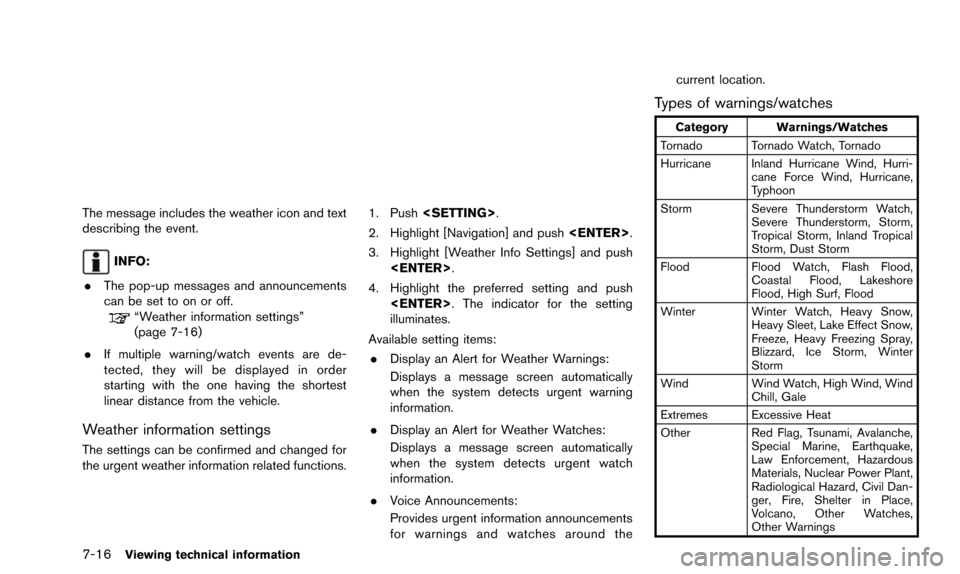
Types of warnings/watches
Category Warnings/Watches
Tornado Tornado Watch, Tornado
Hurricane Inland Hurricane Wind, Hurri- cane Force Wind, Hurricane,
Typhoon
Storm Severe Thunderstorm Watch, Severe Thunderstorm, Storm,
Tropical Storm, Inland Tropical
Storm, Dust Storm
Flood Flood Watch, Flash Flood,
Coastal Flood, Lakeshore
Flood, High Surf, Flood
Winter Winter Watch, Heavy Snow, Heavy Sleet, Lake Effect Snow,
Freeze, Heavy Freezing Spray,
Blizzard, Ice Storm, Winter
Storm
Wind Wind Watch, High Wind, Wind
Chill, Gale
Extremes Excessive Heat
Other Red Flag, Tsunami, Avalanche,
Special Marine, Earthquake,
Law Enforcement, Hazardous
Materials, Nuclear Power Plant,
Radiological Hazard, Civil Dan-
ger, Fire, Shelter in Place,
Volcano, Other Watches,
Other Warnings
Page 177 of 241
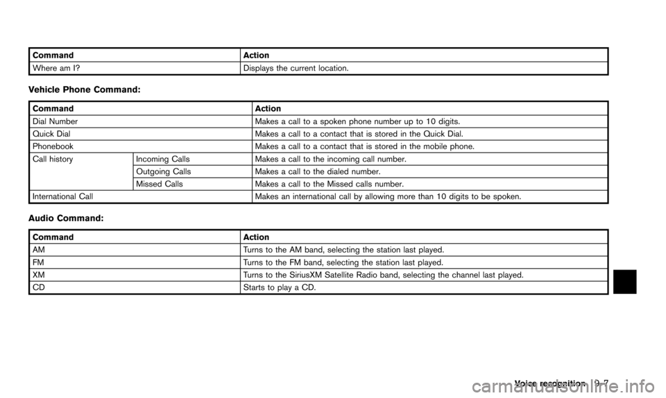
CommandAction
Where am I? Displays the current location.
Vehicle Phone Command:
Command Action
Dial Number Makes a call to a spoken phone number up to 10 digits.
Quick Dial Makes a call to a contact that is stored in the Quick Dial.
Phonebook Makes a call to a contact that is stored in the mobile phone.
Call history Incoming Calls Makes a call to the incoming call number.
Outgoing Calls Makes a call to the dialed number.
Missed Calls Makes a call to the Missed calls number.
International Call Makes an international call by allowing more than 10 digits to be spoken.
Audio Command:
CommandAction
AM Turns to the AM band, selecting the station last played.
FM Turns to the FM band, selecting the station last played.
XM Turns to the SiriusXM Satellite Radio band, selecting the channel last played.
CD Starts to play a CD.
Voice recognition
9-7
Page 186 of 241
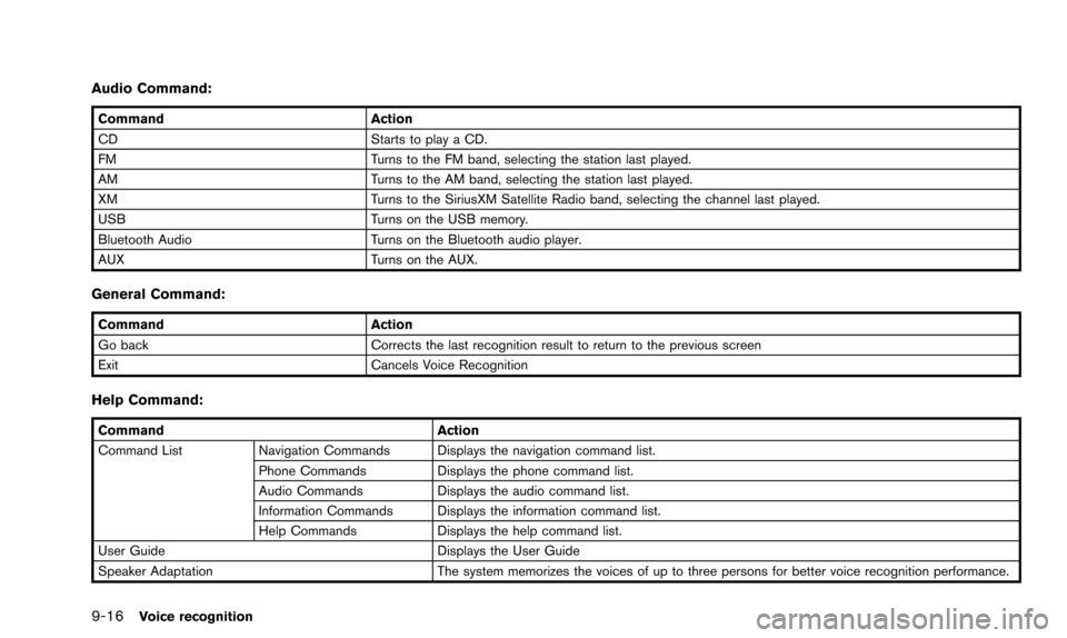
9-16Voice recognition
Audio Command:
CommandAction
CD Starts to play a CD.
FM Turns to the FM band, selecting the station last played.
AM Turns to the AM band, selecting the station last played.
XM Turns to the SiriusXM Satellite Radio band, selecting the channel last played.
USB Turns on the USB memory.
Bluetooth Audio Turns on the Bluetooth audio player.
AUX Turns on the AUX.
General Command:
CommandAction
Go back Corrects the last recognition result to return to the previous screen
Exit Cancels Voice Recognition
Help Command:
Command Action
Command List Navigation Commands Displays the navigation command list.
Phone Commands Displays the phone command list.
Audio Commands Displays the audio command list.
Information Commands Displays the information command list.
Help Commands Displays the help command list.
User Guide Displays the User Guide
Speaker Adaptation The system memorizes the voices of up to three persons for better voice recognition performance.
Page 199 of 241
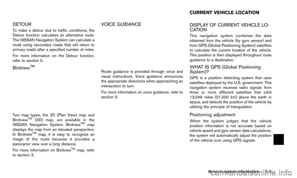
DETOUR
To make a detour due to traffic conditions, the
Detour function calculates an alternative route.
The NISSAN Navigation System can calculate a
route using secondary roads that will return to
primary roads after a specified number of miles.
For more information on the Detour function,
refer to section 5.
BirdviewTM
Two map types, the 2D (Plan View) map and
BirdviewTM(3D) map, are available in the
NISSAN Navigation System. BirdviewTMmap
displays the map from an elevated perspective.
In Birdview
TMmap, it is easy to recognize an
image of the route because it provides a
panoramic view over a long distance.
For more information on Birdview
TMmap, refer
to section 3.
VOICE GUIDANCE
Route guidance is provided through voice and
visual instructions. Voice guidance announces
the appropriate directions when approaching an
intersection to turn.
For more information on voice guidance, refer to
section 5.
DISPLAY OF CURRENT VEHICLE LO-
CATION
This navigation system combines the data
obtained from the vehicle (by gyro sensor) and
from GPS (Global Positioning System) satellites
to calculate the current location of the vehicle.
This position is then displayed throughout route
guidance to a destination.
WHAT IS GPS (Global Positioning
System)?
GPS is a position detecting system that uses
satellites deployed by the U.S. government. This
navigation system receives radio signals from
three or more different satellites that orbit
13,049 miles (21,000 km) above the earth in
space, and detects the position of the vehicle by
utilizing the principle of triangulation.
Positioning adjustment
When the system judges that the vehicle
position information is not accurate based on
vehicle speed and gyro sensor data calculations,
the system will automatically adjust the position
of the vehicle icon using GPS signals.
General system information10-3
CURRENT VEHICLE LOCATION
Page 209 of 241
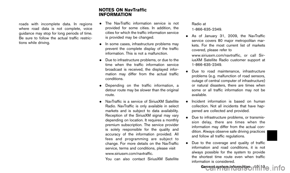
roads with incomplete data. In regions
where road data is not complete, voice
guidance may stop for long periods of time.
Be sure to follow the actual traffic restric-
tions while driving..
The NavTraffic information service is not
provided for some cities. In addition, the
cities for which the traffic information service
is provided may be changed.
. In some cases, infrastructure problems may
prevent the complete display of the traffic
information. This is not a malfunction.
. Due to infrastructure problems, or due to the
time when the traffic information service
broadcast is received, the displayed infor-
mation may differ from the actual traffic
conditions.
. Depending on the traffic information, a
detour route may be slower than the original
route.
. NavTraffic is a service of SiriusXM Satellite
Radio. NavTraffic is only available in select
markets and is subject to data availability.
Reception of the SiriusXM signal may vary
depending on location. It requires a monthly
premium subscription. The service provider
is solely responsible for the quality and
accuracy of the information provided. All
fees and programming are subject to
change. For more details on the NavTraffic
service, terms and conditions, please visit
www.siriusxm.com/navtraffic.
You can also contact SiriusXM Satellite Radio at
1-866-635-2349.
. As of January 31, 2009, the NavTraffic
service covers 80 major metropolitan mar-
kets. For the most current list of markets
covered, please refer to
www.siriusxm.com/navtraffic, or call Sir-
iusXM Satellite Radio customer support at
1-866-635-2349.
. Due to road maintenance, infrastructure
problems (e.g. malfunction of road sensors,
outage of central computer of infrastructure)
or natural disasters, there are times when
some or all traffic information may not be
available.
. Incident information is based on human
collection. Not all incidents that have hap-
pened are collected and provided.
. Due to infrastructure problems, or transmis-
sion delay, there are times when the
information may differ from the actual con-
dition. Always observe safe driving practices
and follow all traffic regulations.
. Due to the coverage and quality of traffic
information and road conditions, it is not
always possible for the system to provide
the shortest time route even when traffic
information is considered.
General system information10-13
NOTES ON NavTraffic
INFORMATION