navigation SKODA OCTAVIA 2016 3.G / (5E) User Guide
[x] Cancel search | Manufacturer: SKODA, Model Year: 2016, Model line: OCTAVIA, Model: SKODA OCTAVIA 2016 3.G / (5E)Pages: 324, PDF Size: 48.85 MB
Page 125 of 324
■Touchscreen tone - Switch on/off audible tone when touching the screen
■No navigation sound during call
- Switching on / off the nav. announcements dur-
ing a telephone call (not applicable to Infotainment Bolero)
Display settings
›
Press the button, then tap on the function surface
Tap →
Screen
.
■
Switch off screen (in 10 seconds)
- Enable / disable the automatic power off func-
tion
■
Brightness:
- Adjusts the brightness of the screen
■
Touchscreen tone
- Switch on/off audible tone when touching the screen
■
Animation when finger near screen
- Turn the proximity sensors on/off (When the
function is on, e.g. Navigation will be shown in the main menu when moving a
finger towards the bottom bar with the function surfaces on the screen)
■
Show clock in standby mode
- Time and date displayed on the screen when the
ignition is switched on and Infotainment is switched off
Time and date settings
›
Press the button, then tap on the function surface
→
Time and date
.
■
Clock time source:
- Setting the time source: Manual / GPS (applies to Infotain-
ment Columbus, Amundsen)
■
Time:
- Time settings
■
Summer time
- Switches the summer time setting on/off (applies to Infotain-
ment Columbus, Amundsen)
■
Automatic summertime
- Turn on / off the automatic switch to daylight saving
time
■
Time zone:
- Choice of time zone
■
Time format:
- Specify the time format
■
Date:
- Date settings
■
Date format:
- Setting the date format
Setting the Infotainment language
›
Press the button, then tap on the function surface
→
Language
.
›
Select the Infotainment language.
In some languages, after selecting the function surface
Female
and
Male
are dis-
played for the choice of voice prompts for Infotainment.
Note■ When a language is selected which does not support voice control, Infotain-
ment will indicate this with a message on the screen.■
The messages are generated by Infotainment. Flawless clarity (e.g. road or
city name) cannot always be guaranteed.
Additional keypad language settings
›
Press the button, then tap on the function surface
→
Additional keypadlanguages
.
In this menu, a keyboard language set can be added to allow the entering of
characters other than those in the currently selected language (function sur-
face ).
Unit settings
›
Press the button, then tap on the function surface
→
Units
.
■
Distance:
- Distance units
■
Speed:
- Speed units
■
Temperature:
- Temperature units
■
Volume:
- Volume units
■
Consumption:
- Consumption units
■
CNG consump.:
- CNG consumption units
■
Pressure:
- Pressure units for tire pressure
Setting data transfer
An active data transfer allows data transfer between Infotainment and the ex-
ternal device (e.g. MirrorLink ®
application) or the operation of some Infotain-
ment functions using the application of the external device (e.g. ŠKODA Media
Command).
›
Press the button, then tap on the function surface
→
Mobile device datatransfer
.
■
Activate data transfer for ŠKODA apps
- Turning data transfer on and off
■
Use apps to operate::
- Setting Infotainment operation via the applications of the
external device (applies to Infotainment Columbus)
■
Deactivate
- Deactivation of Infotainment operation via an external device
■
Confirm
- Infotainment operation with required confirmation
■
Allow
- Infotainment operation without required confirmation
123Infotainment settings - Columbus, Amundsen, Bolero
Page 127 of 324

■Password: ... - Password setting
■Authentication
- Setting for the type of verification
■
Normal
- Without verification
■
Safe
- Verification required
■
Reset Access Point (APN)
- Delete the parameters for the network setting
■
Store
- Storage of the parameters for the network setting
■
Network provider: ...
- Selecting the data service provider (the menu item is visi-
ble when the data services of the SIM card inserted in the external module
are active)
■
Data roaming
- Enable / disable the use of data roaming connection
■
Current connection details
- Display of information on data downloaded (by tap-
ping the function button
Reset
the data information is deleted)
■
Data Connection:
- Settings of the data services of the SIM card inserted in the
external module
■
Off
- The data services are turned off
■
Ask
- The data services are active after confirmation
■
On
- The data services are turned on
System information
›
Press the button, then tap on the function surface
Tap on
→
Systeminformation
.
›
To perform a Software Update (Z. B. Bluetooth®
or radio station logo) Tap
the function surface
Update software
.
Displaying system information.
▶ Device part number: ... - Infotainment part number
▶ Hardware: ... - Hardware version
▶ Software: ... - Software version
▶ Navigation database: ... - Version of the navigation data
▶ “Gracenote” database: ... - Version of the Gracenote multimedia database
(applies to Infotainment Columbus)
▶ Media Codec: ... - Version of media codecs
▶ Bluetooth version: ... - Version of the Bluetooth ®
software
The information on available software updates is obtained from a ŠKODA Part-
ner or from the following ŠKODA Internet pages.
http://go.skoda.eu/updateportal
Radio menu settings
Settings for all broadcasting areas
›
Tap on the Radio main menu function surface
.
■
Sound
- Sound settings
■
Scan
- Automatic play short portions of all available stations in the current
frequency range
■
Arrow buttons:
- Setting the function of the function surfaces
■
Preset list
- Change between stations stored under the preset buttons
■
Station list
- Change between all available stations of the selected broad-
casting range
■
Traffic program (TP)
- Switches TP traffic programme on/off
■
Delete presets
- Deletes the preset buttons
■
Station logos
- manual management of station logos
■
Radio text
- Switching the text display radio (FM and DAB) on and off
■
Advanced settings
- further settings that are different depending on the selec-
ted broadcasting range(FM and DAB)
Advanced Settings (FM)
›
Select the FM band in the Radio main menu and tap on the function surface
→
Advanced settings
.
■
Auto-save station logos
- Automatic storage of the station logos
■
Region for station logo:
- Setting the region for station logos
■
Automatic frequency control (AF)
- Search for alternative frequencies of the station
currently being played to on/off
■
Radio Data System (RDS)
- Activate/deactivate RDS function (receiving additional
information from the station)
■
RDS Regional:
- Switch on/off the automatic tracking of related regional sta-
tions
■
Fixed
- Maintains the selected regional station continuously. When the sig-
nal is lost, another station must be set manually.
■
Automatic
- Auto-selects the station with the best reception at the moment.
If you lose reception in the given the region, Infotainment will automatical-
ly set another available region.
Advanced settings (DAB)
›
In the Radio main menu, select the DAB range and tap on the function sur-
face
→
Advanced settings
.
125Infotainment settings - Columbus, Amundsen, Bolero
Page 130 of 324

■Forward calls - Setting forwarding of incoming calls (valid for Infotainment Co-
lumbus with the SIM card slot in the external module) ■All calls
- Forward all incoming calls
■
If engaged
- Forwarding incoming calls during a telephone call
■
If not available
- Forwarding the incoming calls when the vehicle is outside
the reach of the telephone service provider signal
■
If no answer
- Redirecting incoming calls when the incoming call is not an-
swered
SmartLink menu settings
›
In the SmartLink main menu, tap on the function surface
.
■
Activate data transfer for ŠKODA apps
- Turning data transfer on and off for ŠKODA
applications
■ MirrorLink® - Settings of the system MirrorLink ®
■
Screen orientation:
- Setting the screen orientation
■
Landscape
- Width display
■
Portrait
- Height display
■
Rotated 180 degrees
- Turn on / off the 180 ° inversion
■
Allow MirrorLink® notification to be shown
- Turn on / off the display of messages
of Mirror link ®
applications on the Infotainment screen
Navigation menu settings
Route options
›
In the Navigation main menu, tap on the function surface
Tap on
→
routeoptions
.
■
Suggest 3 alternative routes
- Switch on/off the menu for alternative routes (eco-
nomical, fast, short)
■
Route:
- Setting the preferred route
■
Most frequent routes
- Show/hide the menu of the most frequent routes in the
split screen
■
Dynamic route
- Switch on/off dynamic route recalculation due to TMC traffic
reports
■
Avoid motorways
- Switch on/off the non-use of motorways in the route cal-
culation
■
Avoid ferries and motorail trains
- Switch on/off the non-use of ferries and mo-
torail trains in the route calculation
■
Avoid toll roads
- Switch on/off use of toll roads for route calculation
■
Avoid tunnels
- Switch on/off use of tunnels for route calculation
■
Avoid routes requiring toll stickers - Switch use of routes requiring toll stickers
on/off for route calculation
■Show available toll stickers
- Selection of countries for which a valid toll sticker is
required (routes requiring toll stickers are used for route calculation)
■
Include trailer
- Turn on / off the setting to take a trailer into account for
route calculation » page 180
Map
›
In the Navigation main menu, tap on the function surface
Tap on →
Map
.
■
Show road signs
- Switch on/off the display of traffic signs
■
Lane guidance
- Display of lane guidance on/off
■
Show favourites
- Switch on/off the display of favourites
■
Show POIs
- Switch on/off the display of POIs
■
Select categories for POIs
- Selection of the displayed category POIs
■
Show brands for POIs
- Switch on/off the company logos available for the POIs
shown
Manage memory
›
In the Navigation main menu, tap on the function surface
→
Manage memo-ry
.
■
Sort Contacts:
- Setting the arrangement of the phonebook
■
By surname
- Sorting by the contact surname
■
By first name
- Sorting by the contact first name
■
Define home address
- Enter the home address
■
Delete My POIs
- Deleting own POI categories (Personal POI)
■
Update My POIs (SD / USB)
- Import / update your own POI categories (Personal
POI)
■
Import destinations (SD/USB)
- Import destinations in vCard format
■
Delete user data
- Delete user data (by pressing the function surface
Delete
and
confirm the deletion) ■
Last destinations
- Delete the last destinations
■
Dest. memory
- Delete the stored destinations
■
Routes
- Delete saved routes
■
My points of interest (Personal POI)
- Delete the custom POIs
■
Entered cities
- Delete the history of places already entered via the address
■
Home address
- Delete the stored home address
■
Flagged destination
- Delete the flagged destination
128Infotainment
Page 131 of 324
■Waypoint tour - Delete item in the Waypoint mode menu (applies to Infotain-
ment Columbus)
■Most frequent routes
- Delete the most travelled routes
nav. announcements
›
In the Navigation main menu, tap on the function surface
→
Nav. announce-ments
.
■
Volume
- Volume control of the nav. announcements
■
Entertainment fading (nav. announce.)
- Setting the fading of the audio volume (e.g.
radio volume.) with nav. announcements
■
Nav. announcements:
- Setting the playback method of nav. announcements
■
Comprehensive
- All nav. announcements
■
Brief
- Short nav. announcements
■
Only in the event of issues
- Only nav. announcements when a route is changed
■
No navigation sound during call
- Activate/ deactivate non-playback of nav. an-
nouncements during a telephone call
■
Note: “My POIs”
- Turn on/off an audible indication when approaching a custom
POI (if supported by the imported custom POI) (applies to Infotainment Co-
lumbus)
Top speeds
›
In the Navigation main menu, tap on the function surface
→
Top speeds
.
The maximum speed limits for the current country are displayed.
With the function switched on
Note: national border crossed
» page 129 , Advanced
settings display the country-specific speed limits when crossing international
borders.
Fuel options
›
In the Navigation main menu, tap on the function surface
→
Fuel options
.
■
Select preferred fuel station
- Select your preferred fuel station brand (the selec-
ted station brand will be displayed in the first three positions of the list)
■
Fuel warning
-Turn on- / Off the display of a warning message with the option
to visit the nearest petrol station when the fuel level reaches the reserve
area
Version information›
In the Navigation main menu, tap on the function surface
→
Version infor-mation
.
A list of countries is displayed that exist for the navigation data, together with
the date of the last update.
An update of the navigation data can be carried out by tapping the functional
surface
Update (SD / USB)
.
The information on updating the navigation data is to be obtained from a
ŠKODA partner or on the following ŠKODA Internet pages.
http://go.skoda.eu/updateportal
Advanced settings
›
In the Navigation main menu, tap on the function surface
→
Advanced set-tings
.
■
Time display:
- Select the time display in the status line
■ - Estimated arrival time at destination
■ - Estimated travelling time to the destination
■
Status line:
- Selection of the target type, for which the status line, the route
and travel time are displayed (Here it is also determined which destination
type after selecting
→
is displayed on the map)
■ - Route destination
■ - Next waypoint
■
Note: national border crossed
- Switching on/off the display for information on na-
tional speed limits when crossing the national border
■
Demo mode
- Switch on/off guidance in demo mode
■
Define demo mode starting point
- Specifying the start point of the route guidance
in the demo mode by entering the address or the current vehicle position
129Infotainment settings - Columbus, Amundsen, Bolero
Page 152 of 324

Only valid for the navigation system Columbus
Connectionvariant
The first device (main phone)The second device (additional phone)
Third deviceFourth deviceTelephoneSIM card
(In the external mod- ule)TelephoneSIM card
(In the external mod- ule)
1.
rSAP
incoming / outgoing
Calls, text messages, Phone contacts,
Data connection,
Bluetooth ®
player a)
-HFP
(incoming calls),
Bluetooth ®
player a)-Bluetooth
®
player a)-2.
HFP
(Incoming / outgo-
ing
Calls), text messages, Phone contacts,
Bluetooth ®
player a)
-HFP
(incoming calls),
Bluetooth ®
player a)Data connectionBluetooth ®
player a)-3.
HFP
(Incoming / outgo-
ing
Calls), text messages, Phone contacts,
Bluetooth ®
player a)
--Incoming calls,
Text messages,
Data connectionBluetooth ®
player a)-4.-
incoming / outgoing
Calls, text messages, Phone contacts b)
,
Data connectionHFP (incoming calls),
Text messages,
Bluetooth ®
player a)-Phone contacts b)
,
Bluetooth ®
player a)Bluetooth ®
player a)
a)
In every connection variant, there is an option to only connect an external device as a Bluetooth connection
®
player with Infotainment.
b)
If phone contacts from the third device are imported into infotainment, the telephone contacts of the SIM card inserted in the external module cannot be used.
Applies to Infotainment Amundsen, BoleroThe first device (main phone)The second device (additional phone)HFP (Incoming / outgoing calls), SMS,
Phone contacts,
Bluetooth ®
player a)HFP
(incoming calls),
Bluetooth ®
player a)a)
Only an external device can be connected to Infotainment as a Bluetooth
®
player.
Applies to Infotainment SwingThe first device (main phone)The second device (additional phone)HFP (Incoming / outgoing calls),
Phone contacts,
Bluetooth ®
player a)Bluetooth ®
player a)
a)
Only an external device can be connected to Infotainment as a Bluetooth
®
player.
150Infotainment
Page 168 of 324
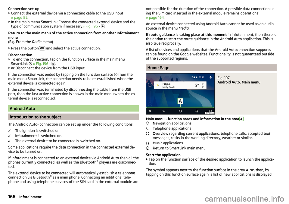
Connection set-up▶ Connect the external device via a connecting cable to the USB input
» page 85 .
▶ In the main menu SmartLink Choose the connected external device and the
type of communication system if necessary » Fig. 196 -
.
Return to the main menu of the active connection from another Infotainment
menu
(E.g. From the Radio menu)
▶ Press the button
and select the active connection.
Disconnection
▶ To end the connection, tap on the function surface in the main menu
SmartLink
» Fig. 196 -
.
▶ or Disconnect the device from the USB input.
If the connection was ended by tapping on the function surface from the
main menu SmartLink, the connection needs to be re-established when the
external device is connected again.
If the connection was terminated by disconnecting the cable from the USB
port, then the last active connection is shown in the main menu when the ex-
ternal device is reconnected.
Android Auto
Introduction to the subject
The Android Auto- connection can be set up under the following conditions. The ignition is switched on.
Infotainment is switched on.
The external device to be connected is switched on.
Some applications require the data connection in the connected external de-
vice to be turned on.
If Infotainment is connected to an external device via Android Auto then all the
phones currently connected, as well as the Bluetooth ®
players are disconnec-
ted.
The external device to be connected will automatically establish a telephone
connection via Bluetooth ®
as a main phone. Connecting an additional tele-
phone and using telephone services of the SIM card in the external module are
not possible for the duration of the connection. A possible data connection us-
ing the SIM card inserted in the external module remains operational
» page 164 .
An external device connected using Android Auto cannot be used as an audio source in the menu Media.
If route guidance is taking place at this moment in Infotainment, then there is
the option to start the route guidance in the Android Auto application. This is
also true reciprocally.
A list of devices and applications that the Android Autoconnection supports
can be found on the Google websites. Functionality is not guaranteed outside
of the supported regions.
Home Page
Fig. 197
Android Auto: Main menu
Main menu - function areas and information in the area
A
Navigation applications
Telephone applications
Overview regarding current applications, telephone calls, accepted text
messages, tasks in the working directory, weather or similar.
Music applications
Return to SmartLink main menu
Start the application ▶ Tap on the function surface of the desired application to launch the applica-
tion.
The symbol appears next to the function surface in the area
A
, then, by
tapping on this function surface again, a list of new applications is displayed.
166Infotainment
Page 171 of 324
■MirrorLink® availability on this mobile device is restricted. Using of the connected de-
vice is not possible while driving
■The mobile device is locked. Please unlock the mobile device to use MirrorLink®
- Unlock
the connected “external device”
■
Unable to start app or app not working.
- Disconnect the external device and recon-
nect
Navigation
Introductory information
Navigation - Function sequence
Applies to Infotainment Columbus, Amundsen.
Route guidance is started as follows.
›
Search for/ enter a new destination or Select one of the stored destinations.
›
Confirm the route calculation in the destination details or if necessary, adjust
the route options.
›
Select the preferred route type, if this is requested by Infotainment.
A route calculation occurs and route guidance starts.
The route guidance is provided by graphical driving recommendations and nav. announcements.
The is an option to add additional destinations during route guidance, or to
adapt the route.
If a traffic radio station is available, information concerning traffic delays is
evaluated by Infotainment and, if necessary, an alternative route is offered.
If you deviate from the route, then a new route calculation is carried out.
GPS satellite signal
Infotainment uses the GPS (Global Positioning System) satellite signal for
route guidance.
Outside the range of the GPS satellite signal (e.g. in dense vegetation, in tun-
nels, parking garages, etc.), Infotainment navigates only with restrictions using
vehicle sensors.
Infotainment offers the option to show in the split screen display the following
Position
» Fig. 204 on page 171 information about the current geographical po-
sition of the vehicle and the satellite signal.
Geographical longitude
Geographical latitude
Elevation
Number of received/available satellites
If no GPS satellite signal is available, no values are displayed.
169Navigation
Page 172 of 324
Navigation data
Navigation data source Columbus
The navigation data is stored in the Infotainment memory.
Navigation data source Amundsen
The navigation data is stored on an Original SD Card.
In order to ensure the function of the navigation, the Original SD card, with the
navigation data, must be inserted in the respective slot in the external module
» page 115 .
If the original SD card is damaged or lost, a new original SD card can be pur-
chased from the ŠKODA Original Accessories.
With a Non-original SD Card, navigation does not work .
Determining the version of the navigation data›
In the Navigation main menu, tap on the function surface
Tap
→
Version in-formation
.
Update navigation data
We recommend that you update the navigation data on a regular basis (e.g.
Due to newly developed roads and changed traffic signs).
The information on updating the navigation data is to be obtained from a
ŠKODA partner or on the following ŠKODA Internet pages.
http://go.skoda.eu/updateportal
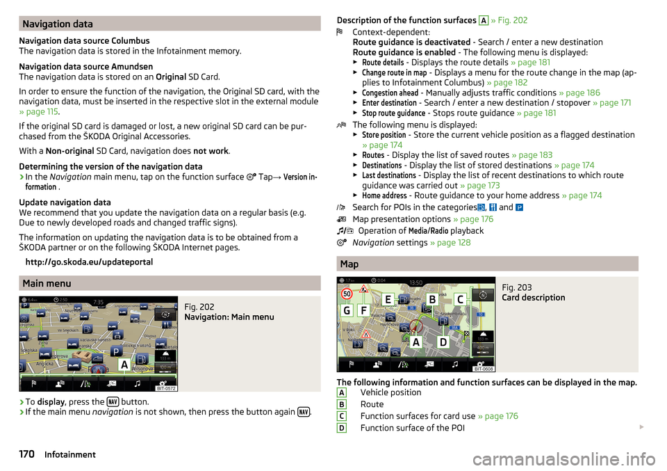
Main menu
Fig. 202
Navigation: Main menu
›
To display , press the button.
›
If the main menu
navigation is not shown, then press the button again .
Description of the function surfaces
A » Fig. 202
Context-dependent:
Route guidance is deactivated - Search / enter a new destination
Route guidance is enabled - The following menu is displayed:
▶Route details
- Displays the route details » page 181
▶
Change route in map
- Displays a menu for the route change in the map (ap-
plies to Infotainment Columbus) » page 182
▶
Congestion ahead
- Manually adjusts traffic conditions » page 186
▶
Enter destination
- Search / enter a new destination / stopover » page 171
▶
Stop route guidance
- Stops route guidance » page 181
The following menu is displayed:
▶
Store position
- Store the current vehicle position as a flagged destination
» page 174
▶
Routes
- Display the list of saved routes » page 183
▶
Destinations
- Display the list of stored destinations » page 174
▶
Last destinations
- Display the list of recent destinations to which route
guidance was carried out » page 173
▶
Home address
- Route guidance to your home address » page 174
Search for POIs in the categories ,
and
Map presentation options » page 176
Operation of
Media
/
Radio
playback
Navigation settings » page 128
Map
Fig. 203
Card description
The following information and function surfaces can be displayed in the map.
Vehicle position
Route
Function surfaces for card use » page 176
Function surface of the POI
ABCD170Infotainment
Page 173 of 324
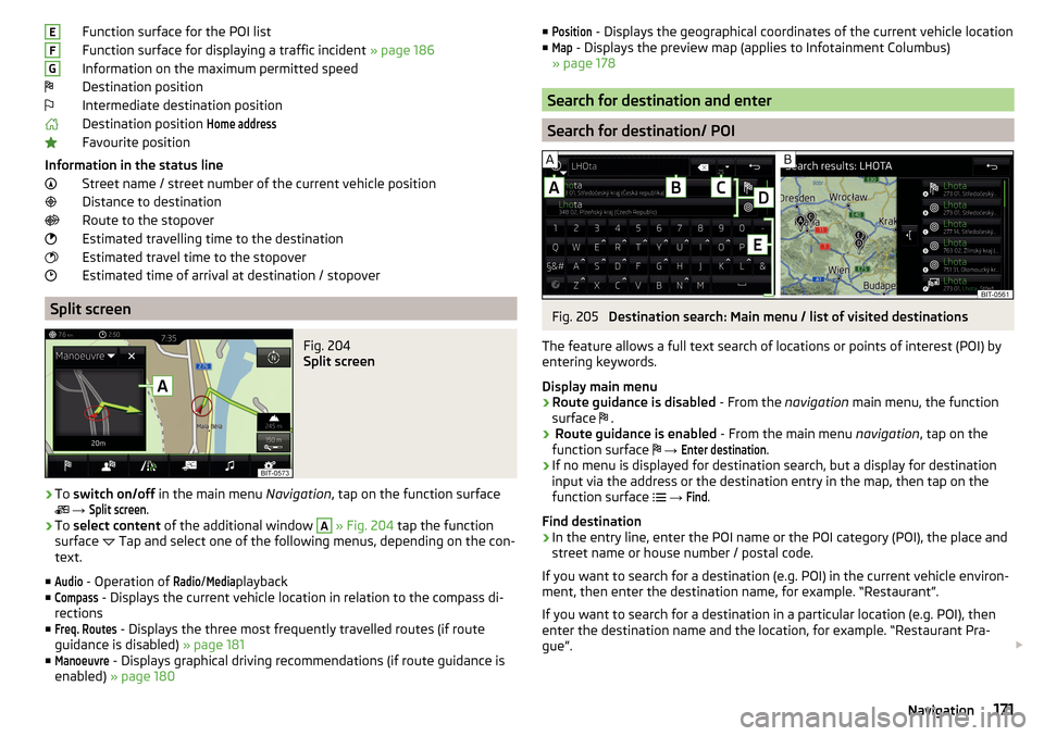
Function surface for the POI list
Function surface for displaying a traffic incident » page 186
Information on the maximum permitted speed
Destination position
Intermediate destination position
Destination position Home address
Favourite position
Information in the status line Street name / street number of the current vehicle position
Distance to destination
Route to the stopover
Estimated travelling time to the destination
Estimated travel time to the stopover
Estimated time of arrival at destination / stopover
Split screen
Fig. 204
Split screen
›
To switch on/off in the main menu Navigation, tap on the function surface
→
Split screen
.
›
To select content of the additional window
A
» Fig. 204 tap the function
surface Tap and select one of the following menus, depending on the con-
text.
■
Audio
- Operation of
Radio
/
Media
playback
■
Compass
- Displays the current vehicle location in relation to the compass di-
rections
■
Freq. Routes
- Displays the three most frequently travelled routes (if route
guidance is disabled) » page 181
■
Manoeuvre
- Displays graphical driving recommendations (if route guidance is
enabled) » page 180
EFG■Position - Displays the geographical coordinates of the current vehicle location
■Map
- Displays the preview map (applies to Infotainment Columbus)
» page 178
Search for destination and enter
Search for destination/ POI
Fig. 205
Destination search: Main menu / list of visited destinations
The feature allows a full text search of locations or points of interest (POI) by
entering keywords.
Display main menu
›
Route guidance is disabled - From the navigation main menu, the function
surface .
›
Route guidance is enabled
- From the main menu navigation, tap on the
function surface
→
Enter destination
.
›
If no menu is displayed for destination search, but a display for destination
input via the address or the destination entry in the map, then tap on the
function surface
→
Find
.
Find destination
›
In the entry line, enter the POI name or the POI category (POI), the place and
street name or house number / postal code.
If you want to search for a destination (e.g. POI) in the current vehicle environ- ment, then enter the destination name, for example. “Restaurant”.
If you want to search for a destination in a particular location (e.g. POI), then
enter the destination name and the location, for example. “Restaurant Pra-
gue”.
171Navigation
Page 174 of 324
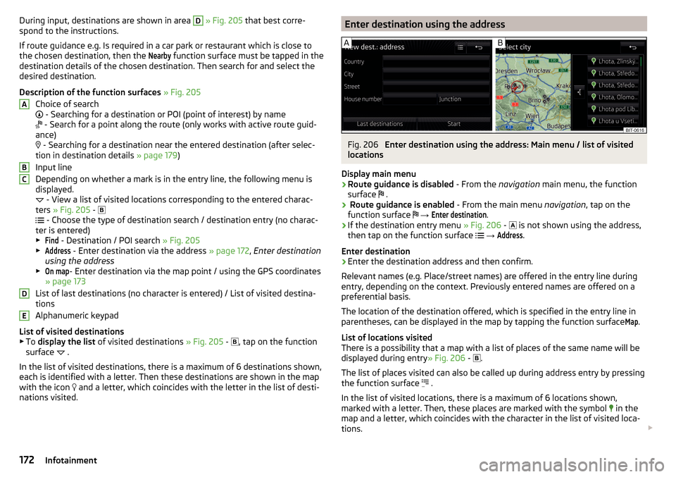
During input, destinations are shown in area D » Fig. 205 that best corre-
spond to the instructions.
If route guidance e.g. Is required in a car park or restaurant which is close to
the chosen destination, then the Nearby
function surface must be tapped in the
destination details of the chosen destination. Then search for and select the
desired destination.
Description of the function surfaces » Fig. 205
Choice of search
- Searching for a destination or POI (point of interest) by name
- Search for a point along the route (only works with active route guid-
ance)
- Searching for a destination near the entered destination (after selec-
tion in destination details » page 179)
Input line
Depending on whether a mark is in the entry line, the following menu is
displayed.
- View a list of visited locations corresponding to the entered charac-
ters » Fig. 205 -
- Choose the type of destination search / destination entry (no charac-
ter is entered)
▶
Find
- Destination / POI search » Fig. 205
▶
Address
- Enter destination via the address » page 172, Enter destination
using the address
▶
On map
- Enter destination via the map point / using the GPS coordinates
» page 173
List of last destinations (no character is entered) / List of visited destina-
tions
Alphanumeric keypad
List of visited destinations
▶ To display the list of visited destinations » Fig. 205 -
, tap on the function
surface .
In the list of visited destinations, there is a maximum of 6 destinations shown,
each is identified with a letter. Then these destinations are shown in the map
with the icon and a letter, which coincides with the letter in the list of desti-
nations visited.
ABCDEEnter destination using the addressFig. 206
Enter destination using the address: Main menu / list of visited
locations
Display main menu
›
Route guidance is disabled - From the navigation main menu, the function
surface .
›
Route guidance is enabled
- From the main menu navigation, tap on the
function surface
→
Enter destination
.
›
If the destination entry menu » Fig. 206 -
is not shown using the address,
then tap on the function surface
→
Address
.
Enter destination
›
Enter the destination address and then confirm.
Relevant names (e.g. Place/street names) are offered in the entry line during entry, depending on the context. Previously entered names are offered on a
preferential basis.
The location of the destination offered, which is specified in the entry line in
parentheses, can be displayed in the map by tapping the function surface
Map
.
List of locations visited
There is a possibility that a map with a list of places of the same name will be
displayed during entry » Fig. 206 -
.
The list of places visited can also be called up during address entry by pressing
the function surface .
In the list of visited locations, there is a maximum of 6 locations shown,
marked with a letter. Then, these places are marked with the symbol in the
map and a letter, which coincides with the character in the list of visited loca-
tions.
172Infotainment