ESP SKODA SUPERB 2015 3.G / (B8/3V) Amundsen Bolero Infotainment System Manual
[x] Cancel search | Manufacturer: SKODA, Model Year: 2015, Model line: SUPERB, Model: SKODA SUPERB 2015 3.G / (B8/3V)Pages: 84, PDF Size: 8.21 MB
Page 50 of 84

Navigation (Amundsen)
Navigation description
Introduction
This chapter contains information on the following subjects:
GPS satellite signal
47
Navigation data
47
Main menu
47
Pop-up windows
48
GPS satellite signal
The unit uses the GPS (Global Positioning System) satellite signal for route
guidance.
Outside the range of the GPS satellite signal (e.g. in dense vegetation, in tun-
nels, parking garages, etc.), the unit navigates only with restrictions using
some on-vehicle sensors (such as speed sensor or steering angle sensor).
The unit offers the possibility to show in the split screen display the following
Position » Fig. 34 on page 48 information about the current geographical po-
sition of the vehicle and the satellite signal.
Geographical longitude
Geographical latitude
Elevation
Number of received/available satellites
To view the information on the longitude and latitude of the current vehicle
position display requires the reception of GPS signals from at least three satel-
lites.
To view the elevation information of the current vehicle position display re-
quires the reception of GPS signals from at least five satellites.
Navigation data
Navigation data source
The navigation data is stored on an Original SD Card .
In order to ensure the function of the navigation, the Original SD card, with the
navigation data, must be inserted in the respective slot » page 25.
If the original SD card should be damaged or lost, a new original SD card can be
purchased from the ŠKODA Original Accessories.
With a Non-original SD Card, the navigation does not work .
Finding out the version of the navigation data › Press in the
Navigation menu the function key
→ Version information .
Update navigation data
We recommend that you update the navigation data on a regular basis (e.g.
Due to newly developed roads and changed traffic signs etc.).
The information on updating the navigation data is to be obtained from a
ŠKODA partner or on the following ŠKODA Internet pages.
http://infotainment.skoda-auto.com
Main menu
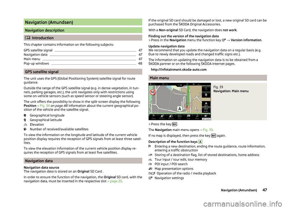
Fig. 33
Navigation: Main menu
›
Press the key .
The Navigation main menu opens » Fig. 33.
If no map is displayed, then press the key
again.
Description of the function keys
A
Entering a new destination, ending the route guidance, route information,
entering a traffic obstruction
Storing of a destination flag, list of stored destinations, home address
Tour input / tour edit, tour memory
POI input / POI search
Map presentation options Operation of the radio / media playback
Navigation settings
47Navigation (Amundsen)
Page 58 of 84

If the map scale of the 2D Map or 3D Map is greater than 10 km (5 miles), then
the map is automatically displayed as 2D and aligned in the direction of north.
If the scale is increased beyond this value, then the map is switched back to
the original representation.
POI in the map
The device offers the possibility of up to 10 POI categories to be display on the
map.
Switch display on/off
›
Press in the Navigation menu the function key
→ POIs .
Select the displayed category
›
Switch on show POIs.
›
Press in the Navigation menu the function key
→ Map → Select catego-
ries for POIs .
›
Select the desired POI category.
Guidance to the POI
›
Press the function key with the symbol of a POI in the map.
The following POI details are displayed.
If the function key includes several POIs, then they will be listed. Select the de-
sired destination from the list, then POI details will be shown.
›
Press the function key Start.
Then a route to the destination is calculated and the route guidance starts.
If the navigation menu for setting the alternative routes is turned on, the guid-
ance for this route type (economic / fast / short) must be selected before start-
ing.
If the destination entry occurs during route guidance, the destination change
must be confirmed by pressing the function key Start in addition to confirming
in the following menu that appears.
Road sign
The device offers the possibility of displaying the traffic signs stored in the
navigation data or detected by the front camera in the device screen
F
» Fig. 41 on page 54 .
Turn on / off the display traffic signs » page 63.
For some vehicles it is possible to set an alert when crossing the permitted
speed limited set by a road sign - Traffic Sign recognition → Warning .
For trailer towing, we recommend switching on the assistance systems option
Traffic Sign recognition → Trailer recognition (show road signs) .
Map Orientation
The map in the 3D display is aligned only with respect to the direction of travel.
The map in the 2D display can be oriented to the north or in relation to the di-
rection of travel.
A change of map orientation is only possible when the map is centred on the
vehicle position (the function key or
is not displayed).
Change the map orientation
›
Press in the Navigation menu the function key
in the area
D
» Fig. 41 on
page 54 .
The map is oriented to the north or in relation to the direction of travel.
The arrow in symbol always points to the north.
The map is oriented to the north
The map does not rotate, the vehicle position symbol rotates.
Map oriented to the direction of travel
The map rotates, the vehicle position symbol does not rotate.
Map scale
It is possible to change the map scale manually or to turn on the automatic
change of scale.
Symbols of the scale function keys
In the map area
D
» Fig. 41 on page 54 the following context-dependent func-
tion keys and information is displayed.
Manually set scaleAutomatically adjusted scale
Turn on / off the automatic change of scale
Map view in reduced scale
Current elevation
Manual change of scale
Map scale can be change in the following ways.
55Navigation (Amundsen)
Page 64 of 84

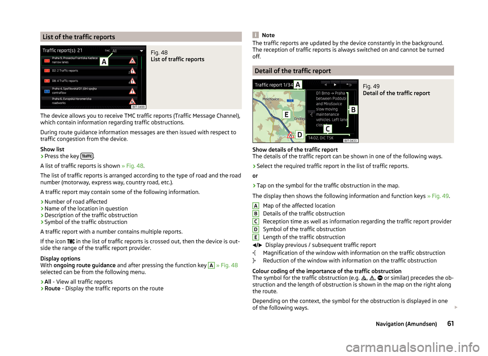
List of the traffic reportsFig. 48
List of traffic reports
The device allows you to receive TMC traffic reports (Traffic Message Channel),
which contain information regarding traffic obstructions.
During route guidance information messages are then issued with respect to
traffic congestion from the device.
Show list
›
Press the key .
A list of traffic reports is shown » Fig. 48.
The list of traffic reports is arranged according to the type of road and the road
number (motorway, express way, country road, etc.).
A traffic report may contain some of the following information.
›
Number of road affected
›
Name of the location in question
›
Description of the traffic obstruction
›
Symbol of the traffic obstruction
A traffic report with a number contains multiple reports.
If the icon in the list of traffic reports is crossed out, then the device is out-
side the range of the traffic report provider.
Display options
With ongoing route guidance and after pressing the function key
A
» Fig. 48
selected can be from the following menu.
›
All - View all traffic reports
›
Route - Display the traffic reports on the route
NoteThe traffic reports are updated by the device constantly in the background.
The reception of traffic reports is always switched on and cannot be turned
off.
Detail of the traffic report
Fig. 49
Detail of the traffic report
Show details of the traffic report
The details of the traffic report can be shown in one of the following ways.
›
Select the required traffic report in the list of traffic reports.
or
›
Tap on the symbol for the traffic obstruction in the map.
The display then shows the following information and function keys » Fig. 49.
Map of the affected location
Details of the traffic obstruction
Reception time as well as information regarding the traffic report provider
Symbol of the traffic obstruction
Length of the traffic obstruction Display previous / subsequent traffic report
Magnification of the window with information on the traffic obstruction
Reduction of the window with information on the traffic obstruction
Colour coding of the importance of the traffic obstruction
The symbol for the traffic obstruction (e.g.
,
,
or similar) precedes the ob-
struction and the length of obstruction is shown in the map on the right along
the route.
Depending on the context, the symbol for the obstruction is displayed in one
of the following ways.
ABCDE61Navigation (Amundsen)
Page 68 of 84

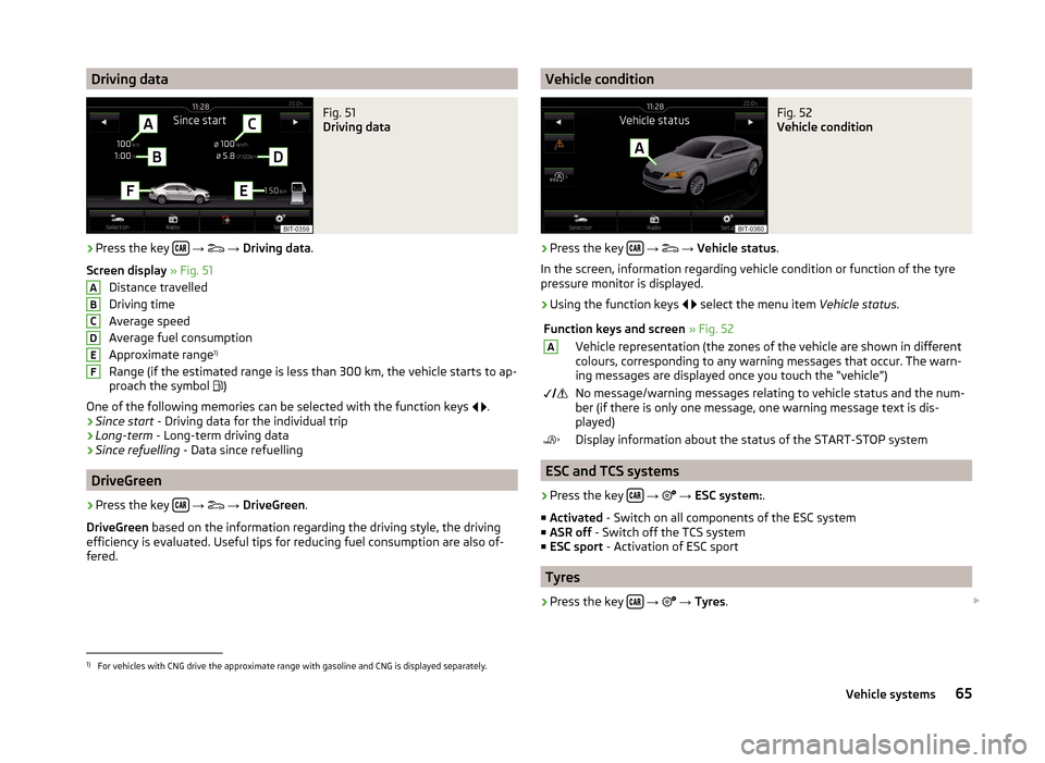
Driving dataFig. 51
Driving data
›
Press the key
→
→ Driving data .
Screen display » Fig. 51
Distance travelled
Driving time
Average speed
Average fuel consumption
Approximate range 1)
Range (if the estimated range is less than 300 km, the vehicle starts to ap-
proach the symbol )
One of the following memories can be selected with the function keys
.
› Since start
- Driving data for the individual trip
› Long-term
- Long-term driving data
› Since refuelling
- Data since refuelling
DriveGreen
›
Press the key
→
→ DriveGreen .
DriveGreen based on the information regarding the driving style, the driving
efficiency is evaluated. Useful tips for reducing fuel consumption are also of-
fered.
ABCDEFVehicle conditionFig. 52
Vehicle condition
›
Press the key
→
→ Vehicle status .
In the screen, information regarding vehicle condition or function of the tyre
pressure monitor is displayed.
›
Using the function keys
select the menu item
Vehicle status.
Function keys and screen » Fig. 52AVehicle representation (the zones of the vehicle are shown in different
colours, corresponding to any warning messages that occur. The warn-
ing messages are displayed once you touch the “vehicle”) No message/warning messages relating to vehicle status and the num-
ber (if there is only one message, one warning message text is dis-
played)Display information about the status of the START-STOP system
ESC and TCS systems
›
Press the key
→
→ ESC system: .
■ Activated - Switch on all components of the ESC system
■ ASR off - Switch off the TCS system
■ ESC sport - Activation of ESC sport
Tyres
›
Press the key
→
→ Tyres .
1)
For vehicles with CNG drive the approximate range with gasoline and CNG is displayed separately.
65Vehicle systems