length SKODA YETI 2014 1.G / 5L Amundsen Infotainment Navigation System Manual
[x] Cancel search | Manufacturer: SKODA, Model Year: 2014, Model line: YETI, Model: SKODA YETI 2014 1.G / 5LPages: 88, PDF Size: 8.18 MB
Page 63 of 88

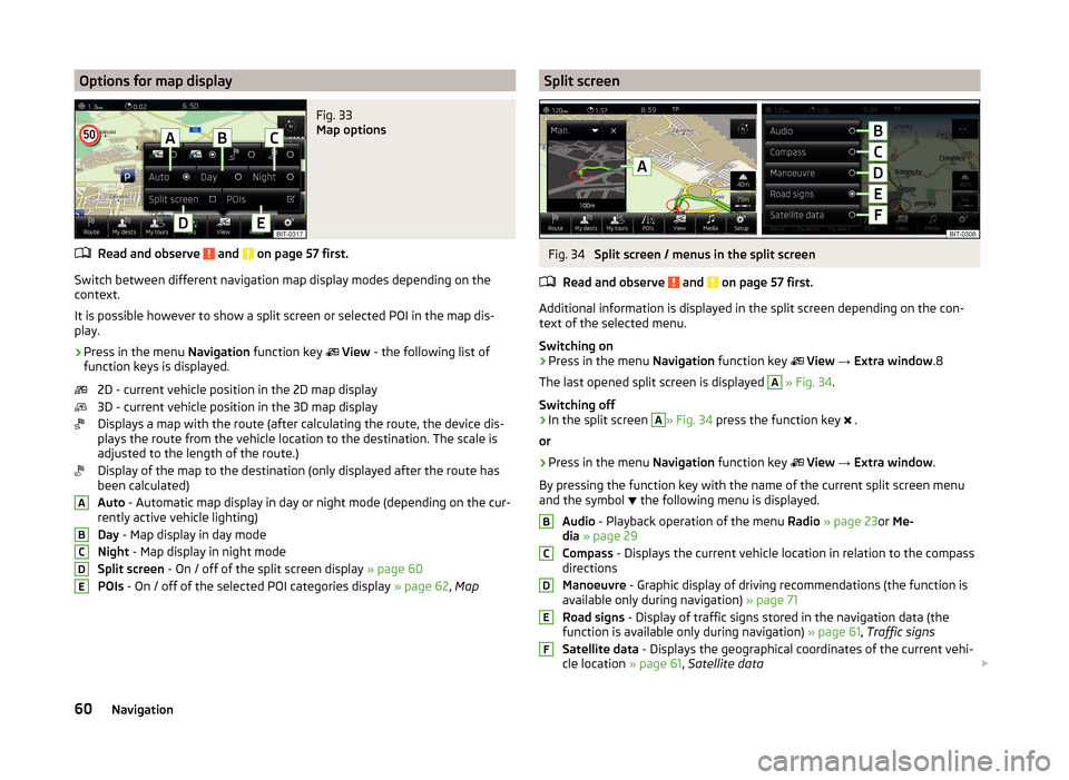
Options for map displayFig. 33
Map options
Read and observe and on page 57 first.
Switch between different navigation map display modes depending on the
context.
It is possible however to show a split screen or selected POI in the map dis-
play.
›
Press in the menu Navigation function key
View - the following list of
function keys is displayed.
2D - current vehicle position in the 2D map display
3D - current vehicle position in the 3D map display
Displays a map with the route (after calculating the route, the device dis-
plays the route from the vehicle location to the destination. The scale is
adjusted to the length of the route.)
Display of the map to the destination (only displayed after the route has
been calculated)
Auto - Automatic map display in day or night mode (depending on the cur-
rently active vehicle lighting)
Day - Map display in day mode
Night - Map display in night mode
Split screen - On / off of the split screen display » page 60
POIs - On / off of the selected POI categories display » page 62, Map
ABCDESplit screenFig. 34
Split screen / menus in the split screen
Read and observe
and on page 57 first.
Additional information is displayed in the split screen depending on the con- text of the selected menu.
Switching on
›
Press in the menu Navigation function key
View → Extra window .8
The last opened split screen is displayed
A
» Fig. 34 .
Switching off
›
In the split screen
A
» Fig. 34 press the function key
.
or
›
Press in the menu Navigation function key
View → Extra window .
By pressing the function key with the name of the current split screen menu
and the symbol the following menu is displayed.
Audio - Playback operation of the menu Radio » page 23 or Me-
dia » page 29
Compass - Displays the current vehicle location in relation to the compass
directions
Manoeuvre - Graphic display of driving recommendations (the function is
available only during navigation) » page 71
Road signs - Display of traffic signs stored in the navigation data (the
function is available only during navigation) » page 61, Traffic signs
Satellite data - Displays the geographical coordinates of the current vehi-
cle location » page 61, Satellite data
BCDEF60Navigation
Page 74 of 88

The route is recalculated each time if you ignore driving recommendations or
change the route. This process takes only a few seconds. Nav. announcements
can only then be re-transmitted.
If Demo mode is switched on » page 62, a prompt appears asking whether you
want the guidance to start in demo mode or normal mode.
Demo mode provides a travel simulation to the entered destination. The func-
tion offers the chance to travel the calculated route “virtually” on the device
screen.
If an alternative route option is set » page 61, then after the route calculation
the following function keys for the choice of route type will be displayed.
- economic route
- fast route
- short route
In the function keys information about the route length and the estimated
travel time are displayed.
It is possible to select a pre-calculated route before the calculation of the re-
maining routes is completed.
Selecting the route type will start route guidance.
If the option for alternative routes is disabled, the route is calculated and route
guidance is started according to the preferred route » page 61.
The unit tries to allow for continued guidance even if the navigation data is in-
complete or there is no data at all for the given area (e.g., one-way streets,
road types, etc.).
Abort route guidance
If the ignition is switched off and on again, then the route guidance is contin-
ued depending on the stop time in one of the following ways.
› Within 15 min - route guidance is continued taking into account the calcula-
ted route.
› From 15 min to 120 min - the device screen displays
Continue route guid-
ance? (after confirming the guidance is continued, taking into account the
calculated route).
› After 120 min - the route guidance is cancelled.
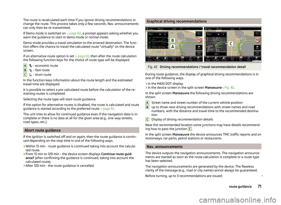
ABCGraphical driving recommendationsFig. 42
Driving recommendations / travel recommendation detail
During route guidance, the display of graphical driving recommendations is in one of the following ways.
› in the MAXI DOT display.
› in the device screen in the split screen
Manoeuvre» Fig. 42.
In the split screen Manoeuvre the following driving recommendations are
shown.
Street name and street number of the current vehicle position
up to three next driving recommendations with street names and road
numbers, with the distance and travel time to the recommended destina-
tion
Display of driving recommendation details
Near the recommended location some junctions may have details recommend- ing how to pass the junction
C
.
In the split screen Manoeuvre the device announces TMC traffic reports and on
motorways, car parks, petrol stations or restaurants.
Nav. announcements
The device outputs the navigation announcements. The navigation announce-
ments are started as soon as the route calculation is complete or a route type
has been selected.
The navigation announcements are generated by the device. The flawless
clarity of the message (e.g., road or city name) cannot always be guaranteed.
Before turning, up to 3 recommendations are issued:
ABC71route guidance