display TOYOTA YARIS 2020 Accessories, Audio & Navigation (in English)
[x] Cancel search | Manufacturer: TOYOTA, Model Year: 2020, Model line: YARIS, Model: TOYOTA YARIS 2020Pages: 94, PDF Size: 1.68 MB
Page 84 of 94

84
Yaris_Yaris hatchback_Navi_OM99V62z_(U)
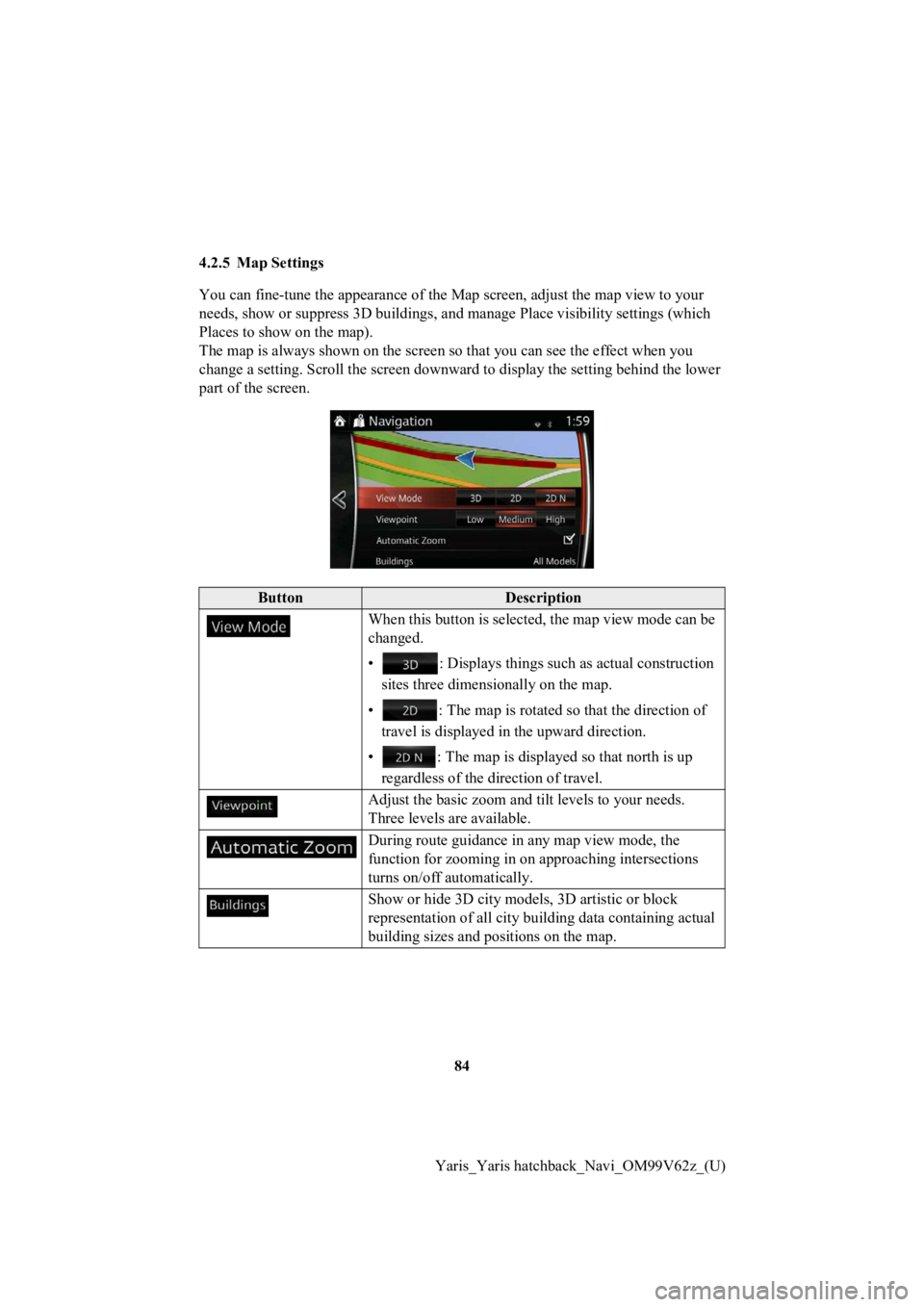
4.2.5 Map Settings
You can fine-tune the appearan
ce of the Map screen, adjust the map view to your
needs, show or suppress 3D build ings, and manage Place visibility settings (which
Places to show on the map).
The map is always shown on the screen so that you can see the effect when you
change a setting. Scroll the screen downward to display the set ting behind the lower
part of the screen.
ButtonDescription
When this button is selected, the map view mode can be
changed.
• : Displays things such as actual construction
sites three dimensionally on the map.
• : The map is rotated so that the direction of
travel is displayed in the upward direction.
• : The map is displayed so that north is up regardless of the direction of travel.
Adjust the basic zoom and tilt levels to your needs.
Three levels are available.
During route guidance in any map view mode, the
function for zooming in on approaching intersections
turns on/off automatically.
Show or hide 3D city model s, 3D artistic or block
representation of all city buil ding data containing actual
building sizes and positions on the map.
Page 86 of 94

86
Yaris_Yaris hatchback_Navi_OM99V62z_(U)
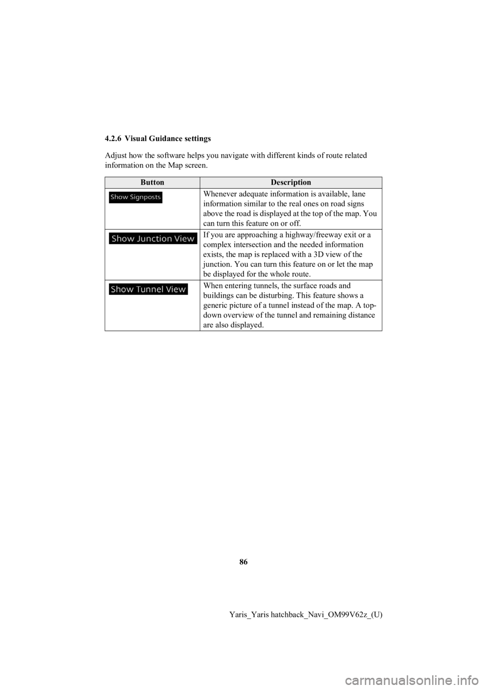
4.2.6 Visual Guidance settings
Adjust how the software helps you navigate with different kinds
of route related
information on the Map screen.
ButtonDescription
Whenever adequate inform ation is available, lane
information similar to the real ones on road signs
above the road is displayed at the top of the map. You
can turn this feature on or off.
If you are approaching a hi ghway/freeway exit or a
complex intersection and the needed information
exists, the map is replaced with a 3D view of the
junction. You can turn this feature on or let the map
be displayed for the whole route.
When entering tunnels, the surface roads and
buildings can be disturbi ng. This feature shows a
generic picture of a tunne l instead of the map. A top-
down overview of the tunne l and remaining distance
are also displayed.
Page 89 of 94

89
1
2
3
4
5
6
Yaris_Yaris hatchback_Navi_OM99V62z_(U)
Map
The navigation system works with
digital maps which are not simply the
computerized versions of traditional paper maps. Similarly to p aper road maps, the
2D mode of digital maps show you streets, roads, and elevation by colors.
In 3D mode, you can see the altitude differences, for example v alleys and mountains,
elevated roads, and in selected cities 3D landmarks and 3D buil dings are also
displayed.
You can use digital maps inter actively: you can zoom in and out (increase or
decrease the scale), yo u can tilt them up and down, and rotate them left and right. In
GPS-supported navigation, digital maps facilitate route plannin g.
North-up map orientation
In North-up mode the map is rotated so its top always faces North. This is the
orientation for example in Find on Map.
Road Safety Camera
This function is not available in some countries and regions.
Special alert points for speed, red light or bus lane cameras. Different data sources
are available. You can configure the navigation system to warn you when you
approach one of these cameras.
Detecting the location of Road Sa fety Cameras is prohibited in certain countries. It is
the sole responsibility of the dr iver to check whether this feature can be used during
the trip.
The software is capable of showing and warning for more than ju st cameras. Various
other types of proximity alert points like school zones and rai lway crossings are also
available.
Route
A sequence of maneuvers (for ex ample, turns and roundabouts) to reach the
destination. The route contains o ne start point and one or more destinations.
Track-up map orientation
In Track-up mode the map is rota ted so its top always points in the current driving
direction. This is the default orientation in 3D map view mode.
Vehicle marker
The current position is indicated by a blue arrow on the map. T he direction the blue
arrow is pointed indicat es the current heading.