ignition VOLVO S60 2020 Sensus Navigation Manual
[x] Cancel search | Manufacturer: VOLVO, Model Year: 2020, Model line: S60, Model: VOLVO S60 2020Pages: 47, PDF Size: 0.69 MB
Page 6 of 47

NAVIGATION
* Option/accessory.
4
Activating and deactivating the navigation system *
The navigation system is automatically acti- vated when the driver's door is opened and isdeactivated when the driver locks and armsthe vehicle.
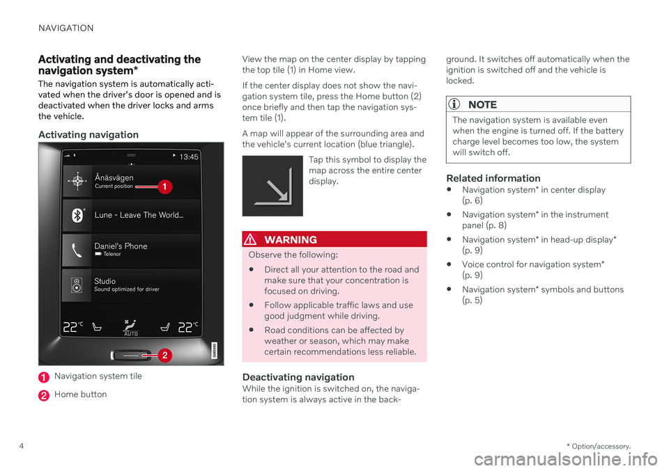
Activating navigation
Navigation system tile
Home button View the map on the center display by tapping the top tile (1) in Home view. If the center display does not show the navi- gation system tile, press the Home button (2)once briefly and then tap the navigation sys-tem tile (1). A map will appear of the surrounding area and the vehicle's current location (blue triangle).
Tap this symbol to display themap across the entire centerdisplay.
WARNING
Observe the following:
Direct all your attention to the road and make sure that your concentration isfocused on driving.
Follow applicable traffic laws and usegood judgment while driving.
Road conditions can be affected byweather or season, which may makecertain recommendations less reliable.
Deactivating navigationWhile the ignition is switched on, the naviga-tion system is always active in the back- ground. It switches off automatically when theignition is switched off and the vehicle islocked.
NOTE
The navigation system is available even when the engine is turned off. If the batterycharge level becomes too low, the systemwill switch off.
Related information
Navigation system
* in center display
(p. 6)
Navigation system
* in the instrument
panel (p. 8)
Navigation system
* in head-up display
*
(p. 9)
Voice control for navigation system
*
(p. 9)
Navigation system
* symbols and buttons
(p. 5)
Page 32 of 47

||
NAVIGATION
30
Transferring map data from the USB flash drive to the vehicle
The time required to transfer data from the USB flash drive to the vehicle varies depend-ing on the size of the map data file. Theupdate can be done while driving. The naviga-tion system can be used while updating a mapregion, but it cannot be used during theupdate of an entire map market, e.g. the EU. Ifthe transfer has not been completed when theignition is switched off, the update will con-tinue the next time the vehicle is driven. It isnot necessary to be driving during the update,but the ignition must be on. If the vehicle isnot driven during the update, battery assis-tance is recommended.
Updating
1. Activate the navigation system.
2. Connect the USB flash drive to the vehi-cle's USB port. If there are two USB ports, the other port cannot be used at the sametime. 3. The navigation system automatically
detects that an update is available and,during the update of the whole map data-base, shows on the screen what percent-age of the process is complete.
> When individual regions are updated,the update will start immediately. To start an update of the entire map database, tap
Confirm. Tap Cancel to
stop the installation.
4. Tap
Confirm. The update of the entire
map database will begin and progress information will be shown on the centerdisplay.
5. The center display will indicate when the update is finished. Remove the USB flashdrive from the port.
6. Restart the infotainment system.
7. Verify that the correct map data has been transferred to the vehicle by repeating the steps described above under "Determin-ing the current map version".
NOTE
In order for the installation to start, the fol- lowing criteria must be met:
Selected region is included on the sys-tem map. For example, only the regionScandinavia can be downloaded if thesystem already has a Europe map. If acompletely new map is downloaded,the previous map will be overwritten.
The version for the selected region ishigher than that in the vehicle.
Selected region is compatible with thecar's software. If the update is notcompatible then new software willneed to be downloaded.
Selected region is compatible withexisting map. If the region is not com-patible, the map must be replaced.
Page 35 of 47

NAVIGATION
}}
* Option/accessory.33
The system uses e.g. toll roads or highways even though I have chosento avoid them
When calculating longer routes over greater distances, the system may choose majorroads for technical reasons. If you have chosen to avoid toll roads and highways, these will be avoided wheneverpossible and only used when no other viableoption is available.
After being transported, the vehicle's
location on the map is not correct
If the vehicle is transported on e.g. a ferry ortrain, or if satellite signals have been blockedfor some other reason, it may take up to5 minutes before the vehicle's location can beaccurately calculated.
The vehicle symbol moves erratically on the screen after changing tires
In addition to satellite signals, the vehicle's speedometer and a gyroscopic sensor are alsoused to calculate location, speed and directionof travel. If any of the tires are changed, e.g. aspare tire or snow tires have been installed,the system needs to "learn" the new tiredimensions. To help ensure the system functions optimally, Volvo recommends driving for a short periodon roads with good satellite reception (clear view).
The map does not represent actual road conditions
Because road changes/additions/rerouting, new traffic regulations, etc. are always beingimplemented, the map database may not beup to date. The database is continuously being updated and improved. Check regularly for updates.
The vehicle symbol jumps around or
spins
The system may need a few seconds to deter-mine the vehicle's location before you startdriving. Switch off both the navigation system and the ignition. Restart but remain at a standstill for amoment before driving.
The map information is not up to dateSee the next heading.
Is the most recent map version installed?
Map information is continuously being upda-ted and improved. When updating maps via acomputer and USB, the vehicle's current mapversion can be displayed. Check the map ver-sion in the vehicle and compare it with availa-ble map versions in the support information atwww.volvocars.com.
Related information
Map updating (p. 27)
Navigation license agreements
*
The following is information for the end-user
of the Sensus Navigation system.
END USER LICENSE AGREEMENT FOR DISTRIBUTION BY HERE
FOR THE AMERICAS/ASIA PACIFIC