Acura ILX 2014 Navigation Manual
Manufacturer: ACURA, Model Year: 2014, Model line: ILX, Model: Acura ILX 2014Pages: 234, PDF Size: 8.8 MB
Page 201 of 234
200
Troubleshooting
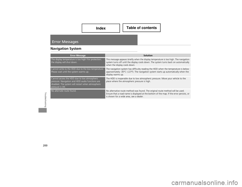
Error Messages
Navigation System
Error MessageSolution
The display temperature is too high! For protection,
the display will shut down.This message appears briefly when the display temperature is too high. The navigation
system turns off until the display cools down. The system turns back on automatically
when the display cools down.
Cannot write to the HDD due to the low temperature.
Please wait until the system warms up.The navigation system has difficulty reading the HDD when the temperature is below
approximately -30°C (-22°F). The navigation system starts up automatically when the
display warms up.
Cannot access the HDD due to low atmospheric
pressure. Navigation and HDD audio functions are
disabled. The system will restart when atmospheric
pressure is OK.The HDD is inoperable due to low atmospheric pressure. Move your vehicle to the
place where the atmospheric pressure is high.
No alternate route found.No alternative route method was found. The original route method will be used.
Ensure that a road name is displayed at the bottom of the map. If the error persists, or
is shown for a wide area, see a dealer.
Page 202 of 234
201
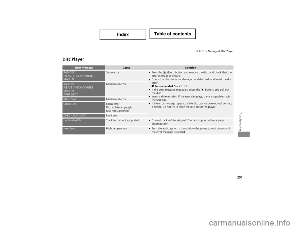
Error MessagesDisc Player
Troubleshooting
Disc Player
Error MessageCauseSolution
BAD DISC
PLEASE CHECK OWNERS
MANUALServo error• Press the E (Eject) button and remove the disc, and check that the
error message is cleared.
• Check that the disc is not damaged or deformed, and insert the disc again.
2 Recommended Discs P. 136
• If the error message reappears, press the E button, and pull out
the disc.
• Insert a different disc. If the new disc plays, there is a problem with the first disc.
• If the error message repeats, or the disc cannot be removed, contact a dealer. Do not try to force the disc out of the player.BAD DISC
PLEASE CHECK OWNERS
MANUAL
PUSH EJECTMechanical error
Mech ErrorMechanical error
Check DiscFocus error
Disc violates copyright
Disc not supported
CHECK DISC LOADLoad error
Unplayable FileTrack format not supported• Current track will be skipped. The next supported track plays automatically.
Heat ErrorHigh temperature• Turn the audio system off and allow the player to cool down until the error message is cleared.
Page 203 of 234
202
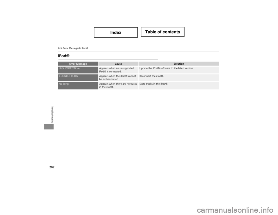
Error MessagesiPod®
Troubleshooting
iPod®
Error MessageCauseSolution
UNSUPPORTED Ver.Appears when an unsupported
iPod® is connected.Update the iPod® software to the latest version.
CONNECT RETRYAppears when the iPod® cannot
be authenticated.Reconnect the iPod®.
No SongAppears when there are no tracks
in the iPod®.Store tracks in the iPod®.
Page 204 of 234
203
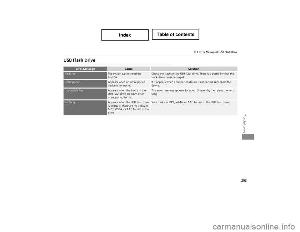
Error MessagesUSB Flash Drive
Troubleshooting
USB Flash Drive
Error MessageCauseSolution
File ErrorThe system cannot read the
track(s).Check the tracks in the USB flash drive. There is a possibility that the
tracks have been damaged.
UnsupportedAppears when an unsupported
device is connected.If it appears when a supported device is connected, reconnect the
device.
Unplayable FileAppears when the tracks in the
USB flash drive are DRM or an
unsupported format.This error message appears for about 3 seconds, then plays the next
song.
No SongAppears when the USB flash drive
is empty or there are no tracks in
MP3, WMA, or AAC format in the
drive.Save tracks in MP3, WMA, or AAC format in the USB flash drive.
Page 205 of 234
204
Page 206 of 234
205
Reference Information
System Initialisation..............................206
Entering the Security Code ....................206
Acquiring GPS Information ....................206
Startup Confirmation Screen .................207
Map Matching ......................................207
System Limitations ................................208
GPS System ...........................................208
Address Calculation ..............................208
Database ..............................................208
Client A ssistance ....................................210
Resolving Problems ...............................210
Reporting Errors ....................................210
Acura Client Relations Contact Information .. 210Visiting a Dealer ....................................210 Map Coverage ..................................... 211
Obtaining a Navigation Update ............ 211
Legal Information ................................. 212
Copyrights ........................................... 212
User Agreements ................................. 212
As required by the FCC ........................ 215
Page 207 of 234
206
Reference Information
System Initialisation
The navigation system must be initialised if
power to the navigation system is
interrupted for any reason (e.g., the
battery was disconnected).
Entering the Security Code
Find the navigation system’s security code
and serial number label in your Owner’s
Manual kit. Do not store the label in your
vehicle. If you lose the label, you must first
retrieve the serial number, and then obtain
the code. You can find out about your
serial number and security code from a
dealer.
1.Set the power mode to ON, and turn on
the audio system.
If you set the power mode to
ACCESSORY, you will be requested
to enter the security code. See step 3.
2. Press and hold the VOL 9 (Volume/
Power) button for more than two
seconds.
The system is reactivated when the
system’s control un it recognizes that
the system is in your vehicle.
If the control unit fails to recognize,
“ENTER CODE” appears on the
navigation screen.
3. Enter the security code.
If you do not enter the security code
correctly after 10 tries, leave the
system for one hour before trying
again, or visit a dealer to have the
system reset.
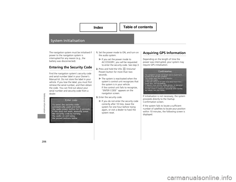
Acquiring GPS Information
Depending on the length of time the
power was interrupted, your system may
require GPS initialisation.
If initialisation is not necessary, the system
proceeds directly to the Startup
Confirmation screen.
If the system fails to locate a sufficient
number of satellites to locate your position
within 10 minutes, the following screen is
displayed.
Page 208 of 234
207
System InitialisationStartup Confirmation Screen
Reference Information
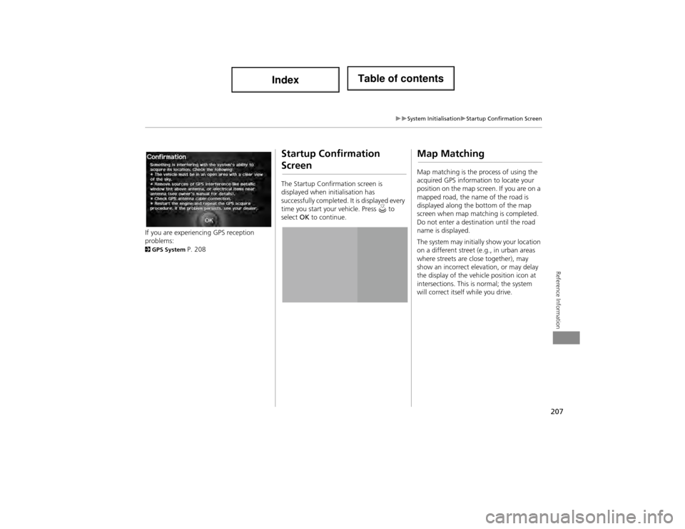
If you are experiencing GPS reception
problems:
2GPS System P. 208
Startup Confirmation
Screen
The Startup Confirmation screen is
displayed when initialisation has
successfully completed. It is displayed every
time you start your vehicle. Press u to
select OK to continue.
Map Matching
Map matching is the process of using the
acquired GPS informati on to locate your
position on the map screen. If you are on a
mapped road, the name of the road is
displayed along the bottom of the map
screen when map matc hing is completed.
Do not enter a destin ation until the road
name is displayed.
The system may initially show your location
on a different street (e.g., in urban areas
where streets are close together), may
show an incorrect elevation, or may delay
the display of the vehi cle position icon at
intersections. This is normal; the system
will correct itself while you drive.
Page 209 of 234
208
Reference Information
System Limitations
GPS System
The signals received from the GPS satellites
are extremely weak (less than a millionth
of the strength of a local FM station) and
require an unobstructed view of the sky.
The GPS antenna is located in the
dashboard. The signal reception can easily
be interrupted or interfered with by the
following:
• Metallic window tint on the front or side
windows
• Cell phones, PDAs, or other electronic
devices docked in a cradle or lying loose
on the dashboard
• Remote starters or “hidden” vehicle
tracking systems mounted near the
navigation unit
• Audio electronic devi ces mounted near
the navigation unit
• Trees, tall buildings, highway
overpasses, tunnels, or overhead
electrical power wires
The GPS is operated by the U.S.
Department of Defense. For security
reasons, there are certain inaccuracies built
into the GPS for which the navigation
system must constantly compensate. This can cause occasional positioning errors of
up to several hundred feet.Address Calculation
The destination icon shows only the
approximate location of a destination
address. This occurs if the number of
possible addresses is different from the
number of actual addresses on a block. For
example, the addres
s 1425 on a 1400
block with 100 possible addresses
(because it is followed by the 1500 block)
will be shown a quarter of the way down
the block by the system. If there are only
25 actual addresses on the block, the
actual location of address 1425 would be
at the end of the block.
Database
The digitised map database reflects
conditions as they existed at various points
in time before production. Accordingly,
your database may contain inaccurate or
incomplete data or information due to the
passage of time, road construction,
changing conditions, or other causes.
For example, some places/landmarks may
be missing when you search the database
because the name was misspelled, the
place was improperly categorised, or a
place/landmark is not yet in the database.
This is also true for police stations,
hospitals, and other public institutions. Do
not rely on the navigation system if you
need law enforcement or hospital services.
Always check with local information
sources.
Page 210 of 234
209
System LimitationsDatabase
Reference Information
In addition, the map database contains
verified and unverified areas. Unverified
streets may be missing from the map, in
the wrong location, or have an incorrect
name or address range. A message will
warn you if your route includes unverified
streets. Exercise additional caution when
driving in unverified areas.
The database does not include, analyse,
process, consider, or reflect any of the
following categories of information:
•Neighbourhood quality or safety
• Population density
• Availability or proximity of law
enforcement
• Emergency, rescue, medical, or other
assistance
• Construction work, zones, or hazards
• Road and lane closures
• Legal restrictions (such as vehicular type,
weight, load, height, and speed
restrictions)
• Road slope or grade
• Bridge height, width, weight, or other
limits
• Traffic facilities safety
• Special events •
Pavement characteristics or conditions
Every effort has been ma de to verify that
the database is accurate. The number of
inaccuracies you expe rience increases the
longer you go without obtaining an
updated map database.
2 Obtaining a Navigation Update P. 211
We assume no liability for any incident that
may result from an error in the
programme, or from changed conditions
not noted above.