display Acura MDX 2011 Navigation Manual
[x] Cancel search | Manufacturer: ACURA, Model Year: 2011, Model line: MDX, Model: Acura MDX 2011Pages: 184, PDF Size: 4.89 MB
Page 127 of 184
Navigation System127
System Initialization
System Initialization
If for any reason you lose power to the
navigation system (e.g., the battery was
disconnected), the navigation system
will require initialization. Once
completed, your system will be ready to
use.
This initialization requires the
following:
• Entry of the 5-digit anti-theft security code to “unlock” the audio and
navigation system.
• GPS initialization (may not be needed depending on the length of time the
system was without power). (See
GPS Initialization on this page.
• Map matching to align the GPS coordinates to a place on the map
(displays current street at the bottom
of the map). (See Map Matching on
page 128.)
Entering the Security Code
If the battery goes dead or is
disconnected for any reason, you will
have to enter a security code for the
audio and navigation system before you
can use it again.
When you purchased the vehicle, you
should have received one card
containing the navigation system’s
security code and serial number. Keep
this card in a safe place in case you need
the code. If you lose the card, you must
obtain the security code from your
dealer.
Enter the 5-digit security code in
accordance with the owner’s manual for
your vehicle. If you do not enter the
security code, the navigation and audio
voice will not function.
NOTE:
The anti-theft security code is unrelated
to your optional navigation system PIN
(for Address Book or Home Address).
GPS Initialization
Depending on the le ngth of time the
battery was disconnected, your system
may require GPS initialization. If it
does, the following screen appears:
If this procedure is not necessary, the
system proceeds directly to the
Disclaimer screen (see page 18).
During initialization, the system
searches for all available GPS satellites
and obtains their orbital information.
During this procedure, the vehicle
should be out in the open with a clear
view of the sky.
2011 MDX
Page 128 of 184
128Navigation System
System Initialization
If the navigation system finds the
satellites properly, this box clears and
the Disclaimer screen is shown. If
within 10 minutes the system fails to
locate a sufficient number of satellites to
locate your position, the following
screen appears:
If the system is still unable to acquire a
signal, follow the in structions on the
screen, or contact yo ur local dealer for
assistance.
NOTE:
The average acquiring time is less than
10 minutes.Map Matching
This part of the initialization matches
the GPS coordinates found above with a
road on the map screen. To perform this
part of the procedur e, ensure that the
navigation system is displaying a map,
and drive the vehicle on a mapped road
(a road shown on the map screen). Do
not enter a destination at this time.
When the name of th e current road you
are driving on appears at the bottom of
the screen, the entire procedure is
complete. Your system is now ready to
use. Although your navigation system is one
of the most highly
sophisticated pieces
of equipment you will find in a modern
automobile, you may find during its use
that it has certain limitations.
The system uses GPS signals to aid in
determining its current location.
The GPS is operated by the U.S.
Department of Defense. For security
reasons, there are certain inaccuracies
built into the GPS that the navigation
system must constantly compensate for.
This can cause occasional positioning
errors of up to several hundred feet.
For example, in urban areas where
streets are close together, this could
cause the system to show that you are
traveling on a street that parallels the
street you are actually on. The system
will, under most circumstances, correct
itself while you drive.
2011 MDX
Page 129 of 184
Navigation System129
System Limitations
Also, depending on your current view of
the sky and the position of the satellites,
the elevation may be shown incorrectly.
You may also notice some delay of the
vehicle position icon at intersections;
this is normal.
GPS Reception Issues
The signals received from the GPS
satellites are extremely weak (less than
a millionth of the strength of a local FM
station) and require an unobstructed
view of sky. The signal can easily be
interrupted or interfered with by the
following:
• Aftermarket metallic window tint
above or to the sides of the GPS
antenna (located on the back of the
navigation display)
• Cell phones, PDAs, or other electronic devices docked in a cradle
or lying loose on the dashboard
• Remote starters or “hidden” vehicle tracking systems mounted near the
navigation unit • Other aftermarket audio electronic
devices mounted near the navigation
unit
• Trees, tall buildings, freeway overpasses, tunnels, or overhead
electrical power wires
Although the system will direct you to
your desired destination, it may not
always generate what you consider to be
the most direct rout e. Try changing the
method of routing. See Changing the
Route Preference on page53. You may
also have Unverified Area Routing set
to OFF. See Unverified Area Routing on
page 106.
Additionally, the mapping database
contains verified and unverified maps.
See Map Overview on page6. A
Disclaimer screen will warn you if your
route includes unverified streets.
Unverified streets may be missing from
the map, in the wrong location, or have
an incorrect name or address range.
Exercise additional caution when
driving in these unverified areas. The destination icon shows the
approximate location of the destination.
This occurs because a city block can
have as many as 100 possible addresses
(for example, the 1400 block is followed
by the 1500 block) Since most cities use
only a portion of the 100 possible
addresses (for example, in the 1400
block, the addresses may only go up to
1425 before the 1500 block starts), the
address 1425 will be shown a quarter of
the way down the block by the system
instead of at the end of the block where
the destination is
actually located.
You may find that the system
occasionally reboots. This is indicated
by the display returning to the
navigation system globe screen. A
reboot can be caused by a number of
things, such as extreme temperatures or
shock from bumpy roads. It does not
necessarily indicate a problem that
requires service. If this happens
frequently, please see your dealer.
2011 MDX
Page 131 of 184
Navigation System
Database Limitations
Traffic facilities safety
Special events
Pavement characteristics or conditions
We assume no liability for any incident
that may result from an error in the
program, or from changed conditions
not noted above. Copyrights
infoUSA-Data: Certain business data
provided by infoUSA, Inc., Omaha,
NE, Copyright © 2009, All Rights
Reserved.
EXIT-Data: © ZENRIN CO., LTD. 2009. All Rights Reserved.
Building foot print: © ZENRIN CO., LTD. 2009. All Rights Reserved.
Junction View Data: © ZENRIN USA, INC. 2009. All rights reserved.
ZAGAT SURVEY: © 2009 Zagat Survey, LLC. Zagat Survey is a
registered trademark of Zagat Survey,
LLC.
Brand icon: The marks of companies displayed by this product to indicate
business locations are the marks of
their respective owners. The use of
such marks in this product does not
imply any sponsorship, approval, or
endorsement by such companies of
this product.
131
2011 MDX
Page 149 of 184
Navigation System149
Coverage Areas
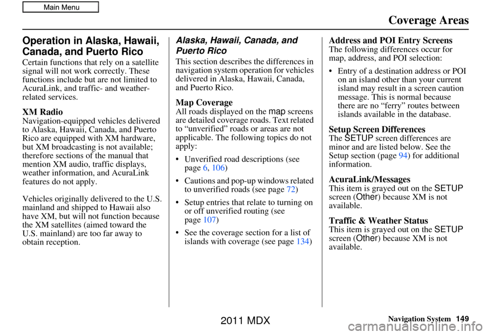
Operation in Alaska, Hawaii,
Canada, and Puerto Rico
Certain functions that rely on a satellite
signal will not work correctly. These
functions include but are not limited to
AcuraLink, and traffic- and weather-
related services.
XM Radio
Navigation-equipped vehicles delivered
to Alaska, Hawaii, Canada, and Puerto
Rico are equipped with XM hardware,
but XM broadcasting is not available;
therefore sections of the manual that
mention XM audio, traffic displays,
weather information, and AcuraLink
features do not apply.
Vehicles originally delivered to the U.S.
mainland and shipped to Hawaii also
have XM, but will not function because
the XM satellites (aimed toward the
U.S. mainland) are too far away to
obtain reception.
Alaska, Hawaii, Canada, and
Puerto Rico
This section describe s the differences in
navigation system operation for vehicles
delivered in Alaska, Hawaii, Canada,
and Puerto Rico.
Map Coverage
All roads displayed on the map screens
are detailed coverage roads. Text related
to “unverified” road s or areas are not
applicable. The followi ng topics do not
apply:
• Unverified road descriptions (see page 6, 106)
• Cautions and pop-up windows related to unverified roads (see page 72)
• Setup entries that re late to turning on
or off unverified routing (see
page 107)
• See the coverage section for a list of islands with coverage (see page 134)
Address and POI Entry Screens
The following differences occur for
map, address, and POI selection:
• Entry of a destination address or POI
on an island other than your current
island may result in a screen caution
message. This is normal because
there are no “ferry” routes between
islands available in the database.
Setup Screen Differences
The SETUP screen differences are
minor and are listed below. See the
Setup section (page 94) for additional
information.
AcuraLink/Messages
This item is grayed out on the SETUP
screen ( Other) because XM is not
available.
Traffic & Weather Status
This item is grayed out on the SETUP
screen ( Other) because XM is not
available.
2011 MDX
Page 150 of 184
150Navigation System
Coverage Areas
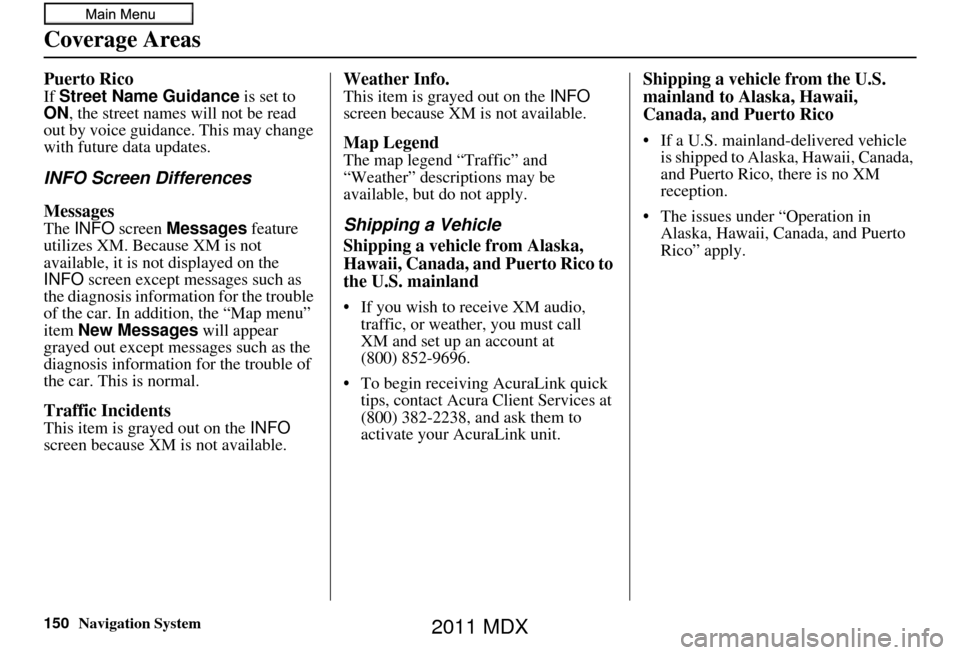
Puerto Rico
If Street Name Guidance is set to
ON , the street names will not be read
out by voice guidance. This may change
with future data updates.
INFO Screen Differences
Messages
The INFO screen Messages feature
utilizes XM. Because XM is not
available, it is not displayed on the
INFO screen except messages such as
the diagnosis informa tion for the trouble
of the car. In addition, the “Map menu”
item New Messages will appear
grayed out except messages such as the
diagnosis information for the trouble of
the car. This is normal.
Traffic Incidents
This item is grayed out on the INFO
screen because XM is not available.
Weather Info.
This item is grayed out on the INFO
screen because XM is not available.
Map Legend
The map legend “Traffic” and
“Weather” descriptions may be
available, but do not apply.
Shipping a Vehicle
Shipping a vehicle from Alaska,
Hawaii, Canada, and Puerto Rico to
the U.S. mainland
• If you wish to receive XM audio, traffic, or weather, you must call
• To begin receiving AcuraLink quick tips, contact Acura Client Services at
(800) 382-2238, and ask them to
activate your AcuraLink unit.
Shipping a vehicle from the U.S.
mainland to Alaska, Hawaii,
Canada, and Puerto Rico
• If a U.S. mainland-delivered vehicle is shipped to Alaska, Hawaii, Canada,
and Puerto Rico, there is no XM
reception.
• The issues under “Operation in Alaska, Hawaii, Canada, and Puerto
Rico” apply.
(800) 852-9696. XM and set up an account at
2011 MDX
Page 151 of 184
Navigation System151
Frequently Asked Questions
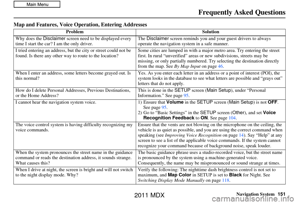
Map and Features, Voice Oper ation, Entering Addresses
Problem Solution
Why does the Disclaimer screen need to be displayed every
time I start the car? I am the only driver. The
Disclaimer screen reminds you and your guest drivers to always
operate the navigation sy stem in a safe manner.
I tried entering an address, but th e city or street could not be
found. Is there any other way to route to the location? Some cities are lumped in with a major metro area. Try entering the street
first. In rural “unverified” areas or new subdivisions
, streets may be
missing, or only partiall y numbered. Try selecting the destination directly
from the map. See By Map Input on page46.
When I enter an address, some letters become grayed out. Is
this normal? Yes. As you enter each letter in an addr
ess or a point of interest (POI), the
system looks in the databa se to see what letters are possible and “grays out”
letters that do not apply.
How do I delete Personal Addre sses, Previous Destinations,
or the Home Address? This is done in the
SETUP screen ( Main Setup ), under “Personal
Information.” See page 95.
I cannot hear the navigation system voice. 1) Ensure that Volume in the SETUP screen (Main Setup ) is not OFF.
See page 95.
2) Go to “Basic Settings” in the SETUP screen ( Other), and set Voice
Recognition Feedback to ON . See page 104.
The voice control system is ha ving difficulty recognizing my
voice commands. Ensure that the vents are not blowing on the microphone on the ceiling, the
vehicle is as quiet as
possible, and you are using the correct command when
speaking (see Improving Voice Recognition on page14). Say “Help” at any
screen to see a list of the applicable voice commands. If the system cannot
recognize your command because of background noise, speak louder.
When the system pronounces the street name in the guidance
command or reads the destinati on address, it sounds strange.
What causes this? The basic guidance phrase uses a studio
-recorded voice, but the street name
is pronounced by the system us ing a machine-generated voice.
Consequently, the name may be misp ronounced or sound strange at times.
When I drive at night, the screen is bright and will not switch
to the night display mode. Why? Verify the following: Th
e nighttime dash brightness control is not set to
maximum, and Map Color in SETUP is set to Black for Night. See
Switching Display Mode Manually on page118.
2011 MDX
Page 152 of 184
152Navigation System
Frequently Asked Questions
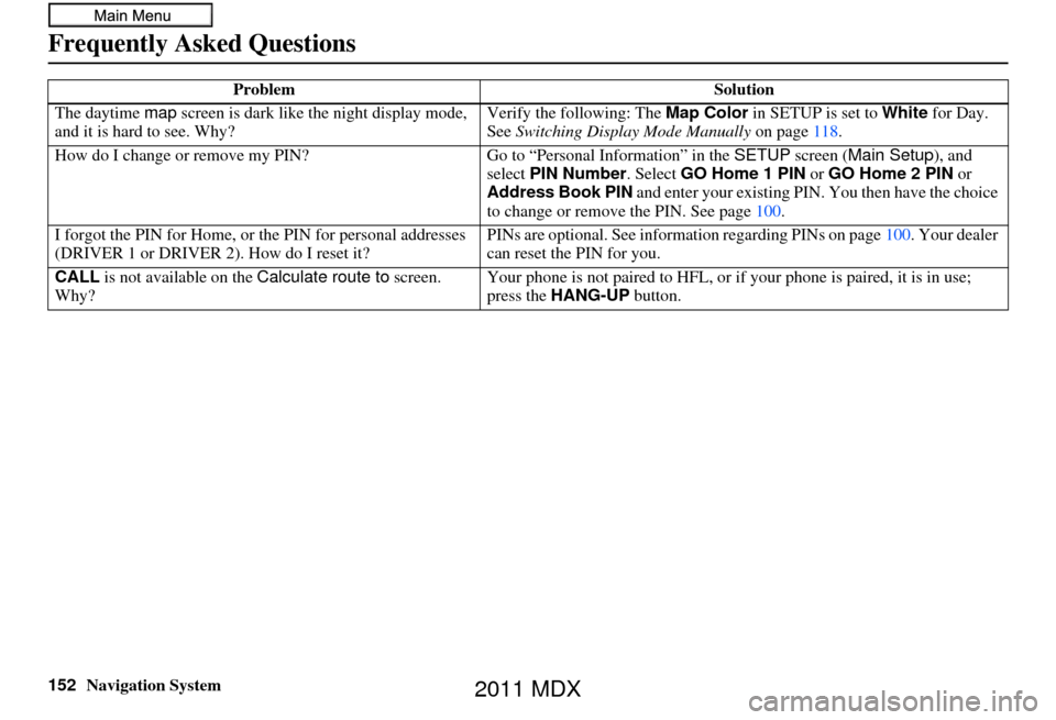
The daytime map screen is dark like the night display mode,
and it is hard to see. Why? Verify the following: The
Map Color in SETUP is set to White for Day.
See Switching Display Mode Manually on page118.
How do I change or remove my PIN? Go to “Personal Information” in the SETUP screen ( Main Setup ), and
select PIN Number . Select GO Home 1 PIN or GO Home 2 PIN or
Address Book PIN and enter your existing PIN. You then have the choice
to change or remove the PIN. See page 100.
I forgot the PIN for Home, or the PIN for personal addresses
(DRIVER 1 or DRIVER 2). How do I reset it? PINs are optional. See information re
garding PINs on page100. Your dealer
can reset the PIN for you.
CALL is not available on the Calculate route to screen.
Why? Your phone is not paired to HFL, or if
your phone is paired, it is in use;
press the HANG-UP button.
Problem
Solution
2011 MDX
Page 153 of 184
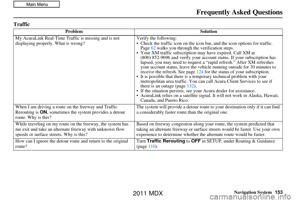
Navigation System153
Frequently Asked Questions
Traffic
Problem Solution
My AcuraLink Real-Time Tra ffic is missing and is not
displaying properly. What is wrong? Verify the following:
• Check the traffic icon on the icon ba
r, and the icon options for traffic.
Page 62 walks you through the verification steps.
• Your XM traffic subscription may ha ve expired. Call XM at
your subscription has
.” After XM refreshes
e running outside for 30 minutes to
124 for the status of your subscription.
• It is possible that there is a te mporary technical problem with your
metropolitan area traffic. You can call Acura Client Services to see if
there is an outage (page 132).
• If the situation persists, see your Acura dealer for assistance.
• AcuraLink relies on a satellite signal. It will not work in Alaska, Hawaii, Canada, and Puerto Rico.
When I am driving a route on the freeway and Traffic
Rerouting is ON, sometimes the system provides a detour
route. Why is this? The system will provide a detour route
to your destination only if it can find
a considerably faster route than the original one.
While traveling on my route on the freeway, the system has
me exit and take an altern ate freeway with unknown flow
speeds or surface st reets. Why is this? Based on freeway c
ongestion along your route, the system predicted that
taking an alternate freeway or surface streets would be faster. Use your own
experience to determine whether th e alternate route would be faster.
How can I ignore the detour route and return to the original
route? Turn
Traffic Rerouting to OFF in SETUP, under Routing & Guidance
(page 110).
(800) 852-9696 and verify your account status. If
lapsed, you may need to request a “rapid refresh
your account status, leave the vehicl
receive the refresh. See page
2011 MDX
Page 154 of 184
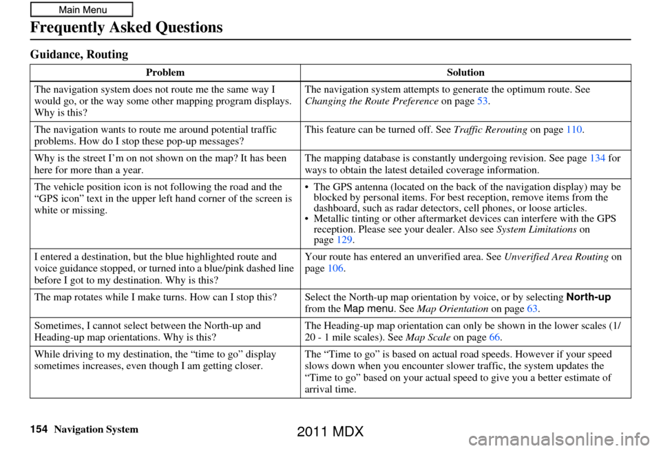
154Navigation System
Frequently Asked Questions
Guidance, Routing
ProblemSolution
The navigation system does not route me the same way I
would go, or the way some ot her mapping program displays.
Why is this? The navigation system attempts to
generate the optimum route. See
Changing the Route Preference on page53.
The navigation wants to rout e me around potential traffic
problems. How do I stop these pop-up messages? This feature can be turned off. See
Traffic Rerouting on page110.
Why is the street I’m on not shown on the map? It has been
here for more than a year. The mapping database is
constantly undergoing revision. See page134 for
ways to obtain the latest de tailed coverage information.
The vehicle position icon is not following the road and the
“GPS icon” text in the upper left hand corner of the screen is
white or missing. • The GPS antenna (located on the back
of the navigation display) may be
blocked by personal items. For best reception, remove items from the
dashboard, such as radar detector s, cell phones, or loose articles.
• Metallic tinting or othe r aftermarket devices can interfere with the GPS
reception. Please see your dealer. Also see System Limitations on
page 129.
I entered a destination, but th e blue highlighted route and
voice guidance stopped, or turned into a blue/pink dashed line
before I got to my dest ination. Why is this? Your route has entered
an unverified area. See Unverified Area Routing on
page 106.
The map rotates while I make turns. How can I stop this? Select the North-up map orientati on by voice, or by selecting North-up
from the Map menu . See Map Orientation on page 63.
Sometimes, I cannot select between the North-up and
Heading-up map orienta tions. Why is this? The Heading-up map orientat
ion can only be shown in the lower scales (1/
20 - 1 mile scales). See Map Scale on page66.
While driving to my destinati on, the “time to go” display
sometimes increases, even though I am getting closer. The “Time to go” is based on actual
road speeds. However if your speed
slows down when you encounter slower traffic, the system updates the
“Time to go” based on your actual spee d to give you a better estimate of
arrival time.
2011 MDX