navigation system ACURA RL KA9 1996 Service Repair Manual
[x] Cancel search | Manufacturer: ACURA, Model Year: 1996, Model line: RL KA9, Model: ACURA RL KA9 1996Pages: 1954, PDF Size: 61.44 MB
Page 43 of 1954
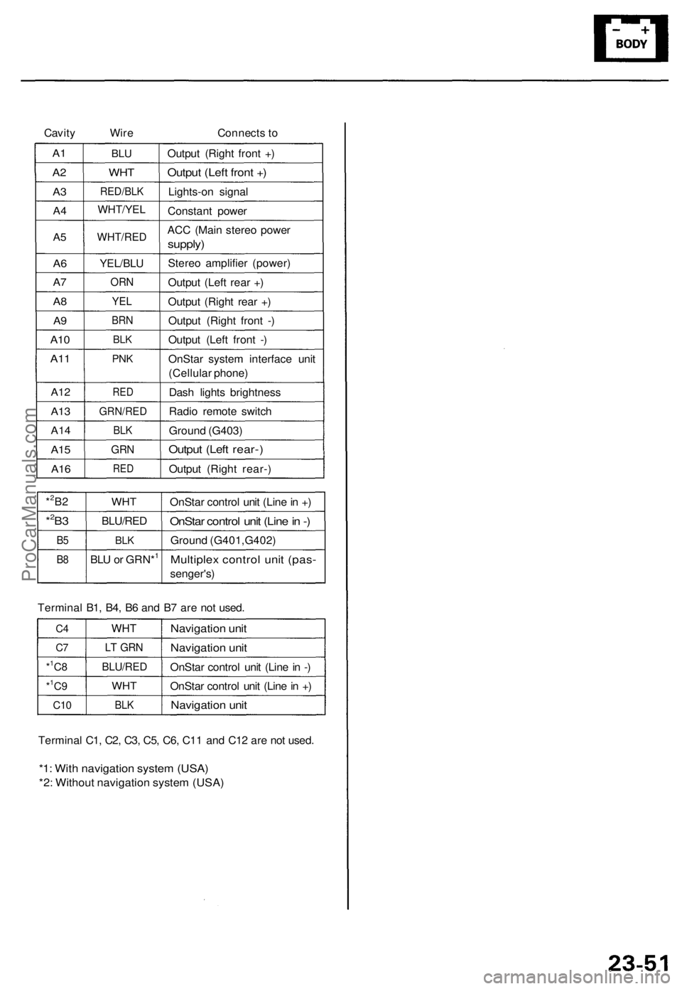
Cavity
Wire
Connects to
A1
A2
A3
A4
A5
A6
A7
A8
A9
A10
A11
A12
A13
A14
A15
A16
BLU
WHT
RED/BLK
WHT/YEL
WHT/RED
YEL/BLU
ORN
YEL
BRN
BLK
PNK
RED
GRN/RED
BLK
GRN
RED
Output (Right front +)
Output (Left front +)
Lights-on signal
Constant power
ACC (Main stereo power
supply)
Stereo amplifier (power)
Output (Left rear +)
Output (Right rear +)
Output (Right front -)
Output (Left front -)
OnStar system interface unit
(Cellular phone)
Dash lights brightness
Radio remote switch
Ground (G403)
Output (Left rear-)
Output (Right rear-)
*2B2
*2B3
B5
B8
WHT
BLU/RED
BLK
BLU or GRN*1
OnStar control unit (Line in +)
OnStar control unit (Line in -)
Ground (G401,G402)
Multiplex control unit (pas-
senger's)
Terminal B1, B4, B6 and B7 are not used.
C4
C7
*1C8
*1C9
C10
WHT
LT GRN
BLU/RED
WHT
BLK
Navigation unit
Navigation unit
OnStar control unit (Line in -)
OnStar control unit (Line in +)
Navigation unit
Terminal C1, C2, C3, C5, C6, C11 and C12 are not used.
*1: With navigation system (USA)
*2: Without navigation system (USA)ProCarManuals.com
Page 219 of 1954
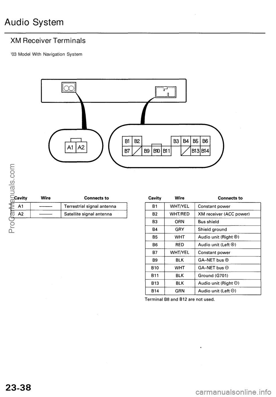
Audio System
XM Receiver Terminals
'03 Model With Navigation SystemProCarManuals.com
Page 224 of 1954
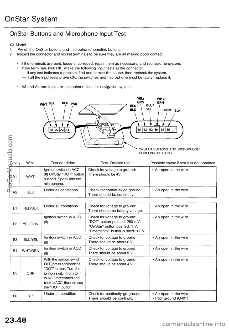
OnStar System
OnStar Buttons and Microphone Input Test
'03 Model
1. Pry off the OnStar buttons and microphone/homelink buttons.
2. Inspect the connector and socket terminals to be sure they are all making good contact.
• If the terminals are bent, loose or corroded, repair them as necessary, and recheck the system.
• If the terminals look OK, make the following input tests at the connector.
— If any test indicates a problem, find and correct the cause, then recheck the system.
— If all the input tests prove OK, the switches and microphone must be faulty; replace it.
•: A3 and A4 terminals are microphone lines for navigation system.
ONSTAR BUTTONS AND MICROPHONE/
HOMELINK BUTTONS
Cavity Wire
Test condition
Test: Desired result
Possible cause if result is not obtained
A1
A2
WHT
BLK
Ignition switch in ACC
(II) OnStar "DOT" button
pushed. Speak into the
microphone.
Under all conditions
Check for voltage to ground:
There should be 4V.
Check for continuity go ground:
There should be continuity.
• An open in the wire
• An open in the wire
B1
B2
B3
B4
B5
B6
RED/BLK
YEL/GRN
BLU/YEL
WHT/GRN
ORN
BLK
Under all conditions
Ignition switch in ACC
(II)
Ignition switch in ACC
(II)
Ignition switch in ACC
(II)
With the ignition switch
OFF, press and hold the
"DOT" button. Turn the
ignition switch from OFF
to ACC three times and
back to ACC, then release
the "DOT" button.
Under all condition
Check for voltage to ground:
There should be battery voltage.
Check for voltage to ground:
"DOT" button pushed: 280 mV.
"OnStar" button pushed: 1 V.
"Emergency" button pushed: 1.7 V.
Check for voltage to ground:
There should be about 8 V.
Check for voltage to ground:
There should be about 8 V.
Check for voltage to ground:
There should be about 4 V.
Check for continuity go ground:
There should be continuity.
• An open in the wire
• An open in the wire
• An open in the wire
• An open in the wire
• An open in the wire
• An open in the wire
• Poor ground (G401)ProCarManuals.com
Page 229 of 1954
Navigation Syste m
Genera l Troubleshootin g Informatio n
General Operatio n
Refer t o th e Acur a Navigatio n Syste m Owner' s manua l
fo r th e navigatio n syste m operatin g procedures .
Anti-theft Featur e
The navigatio n syste m ha s a code d thef t protectio n cir -
cuit . B e sur e t o ge t th e customer' s 4-digi t securit y cod e
numbe r before :
• disconnectin g th e batter y
• disconnectin g th e navigatio n uni t 8 P connecto r
• removin g th e No . 5 6 (7.5A ) fus e fro m th e under-hoo d
fuse/rela y bo x
Afte r service , reconnec t powe r t o th e navigatio n unit ,
an d tur n th e ignitio n switc h O N (II) . Ente r th e 4-digi t
securit y code , the n selec t "Done" .
I f th e cod e canno t b e found , us e th e interactiv e Networ k
( iN ) t o loo k i t up . Yo u wil l nee d th e seria l numbe r fo r
th e navigatio n uni t i n th e trunk . I t i s o n a ta g o n th e
undersid e o f th e unit . Alternatively , yo u ca n vie w th e
seria l numbe r i n on e o f th e Nav i EC U diagnosti c
screens.
When replacin g th e navigatio n unit , b e sur e t o giv e th e
custome r th e ne w anti-thef t securit y code .
Sympto m Diagnosi s
Under som e circumstances , th e navigatio n syste m ma y
behav e in a n inconsisten t manner . Som e customer s ma y
thin k tha t thi s indicate s a proble m when , i n fact , th e
syste m is workin g properly . Kee p th e followin g item s i n
min d whe n interviewin g customer s abou t symptom s
o f th e navigatio n system .
Self-lnertia l Navigatio n Limitation s
When GP S signal s canno t b e receive d (lik e in a tunne l o r
i n a n urba n environmen t o f tal l buildings) , th e syste m is
totall y dependan t o n th e ya w rat e an d spee d senso r t o
positio n th e vehicl e o h th e map . Unde r thes e circum -
stance s smal l error s i n th e ya w rat e an d spee d senso r
ca n accumulat e an d displa y th e vehicl e positio n o n a n
adjacen t street , o r laggin g behin d th e actua l position .
Thi s i s normal , an d usuall y correct s itsel f onc e sate -
llit e receptio n is re-established .
Th e followin g circumstance s ma y cause s vehicl e posi -
tionin g errors . •
Movin g th e vehicl e wit h th e navigatio n syste m o n an d
th e vehicl e stopped , suc h a s b y ferr y o r to w truck , o r i f
th e vehicl e is spu n o n a tur n tabl e
• Tir e slippage , change s i n tir e rollin g diameters , an d
som e drivin g situation s ma y caus e discrepancie s i n
trave l distances . Example s o f thi s include :
- Continuou s tir e slippag e o n a slipper y surfac e
- Drivin g wit h sno w chain s mounte d
-Abnorma l tir e pressur e
- Incorrec t tir e siz e
- Frequen t lan e change s acros s a wid e highwa y
-Continuou s drivin g o n a straigh t o r gentl y curvin g
highwa y
• Tolerance s i n th e syste m an d ma p inaccuracie s some -
times limi t ho w precisel y th e vehicl e positio n i s indi -
cated . Example s o f thi s include :
- Drivin g o n road s no t show n o n th e ma p (ma p match -
in g i s no t possible )
- Drivin g o n a roa d tha t wind s i n on e direction , suc h a s
a loo p bridge , a n interchange , o r a spira l parkin g
garage
-Drivin g o n a roa d wit h a serie s o f shar p hair-pi n
turn s
- Drivin g nea r a gradua l highwa y exi t o r transitio n
- Drivin g o n on e o f tw o close paralle l road s
- Makin g man y 9 0 degre e turn s
Globa l Positionin g Syste m (GPS ) Limitation s
The GP S canno t detec t th e vehicle' s positio n durin g th e
followin g instances :
• Fo r th e firs t 5 to 1 0 minute s afte r reconnectin g th e bat -
ter y (thi s ca n tak e a s lon g a s 4 5 minutes )
• Whe n th e satellit e signal s ar e blocke d b y tal l building ,
mountains , tunnels , larg e trees , o r larg e truck s
• Whe n ther e i s n o satellit e signa l outpu t (Signa l outpu t
i s sometime s stoppe d fo r satellit e servicing )
• Whe n th e satellit e signal s ar e blocke d b y th e operatio n
of som e electroni c aftermarke t accessorie s including ,
but no t limite d t o non-DE M in-das h entertainmen t
unit s (radio , C D players/changers , an d L o Jack ) an d
windo w tintin g abov e th e GP S antenn a
Th e accurac y o f GP S is reduce d durin g thes e instances :
• Whe n onl y tw o satellit e signal s ca n b e receive d (Thre e
satellit e signal s ar e require d fo r accurat e positioning )
• Whe n th e satellit e contro l center s ar e experiencin g
problem s
• Whe n drivin g hea r hig h tensio n powe r lines .
• Whe n drivin g nea r tal l building s tha t reflec t satellit e
signals , creatin g fals e positio n locatio n readings .
• I f electroni c GP S jammin g i s occurrin g eithe r inten -
tionally , o r unintentionally .
• I f loos e item s o r pet s ar e restin g abov e th e antenn a
o n th e rea r shelf .
ProCarManuals.com
Page 232 of 1954
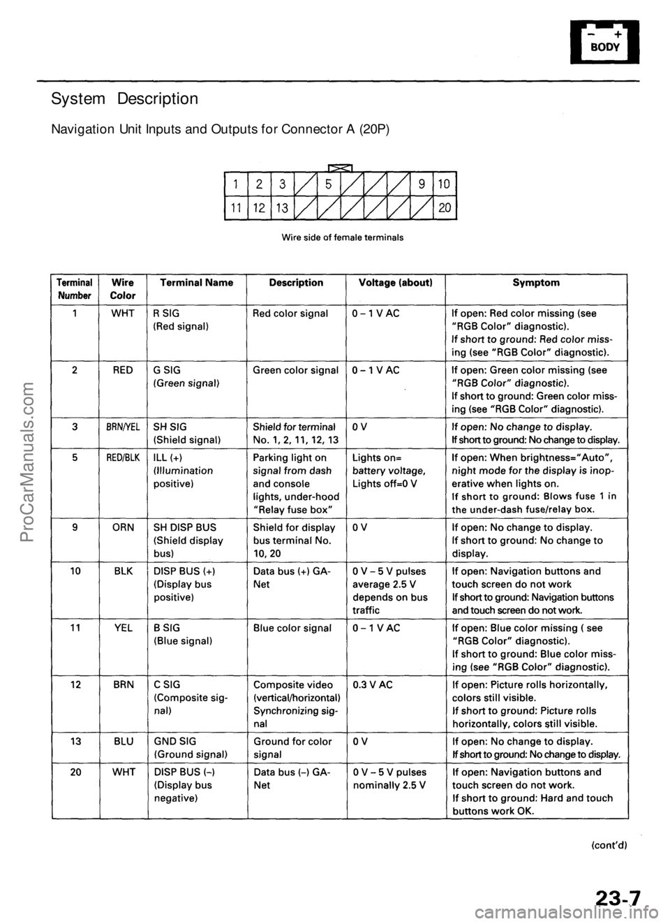
System Description
Navigation Unit Inputs and Outputs for Connector A (20P)ProCarManuals.com
Page 233 of 1954
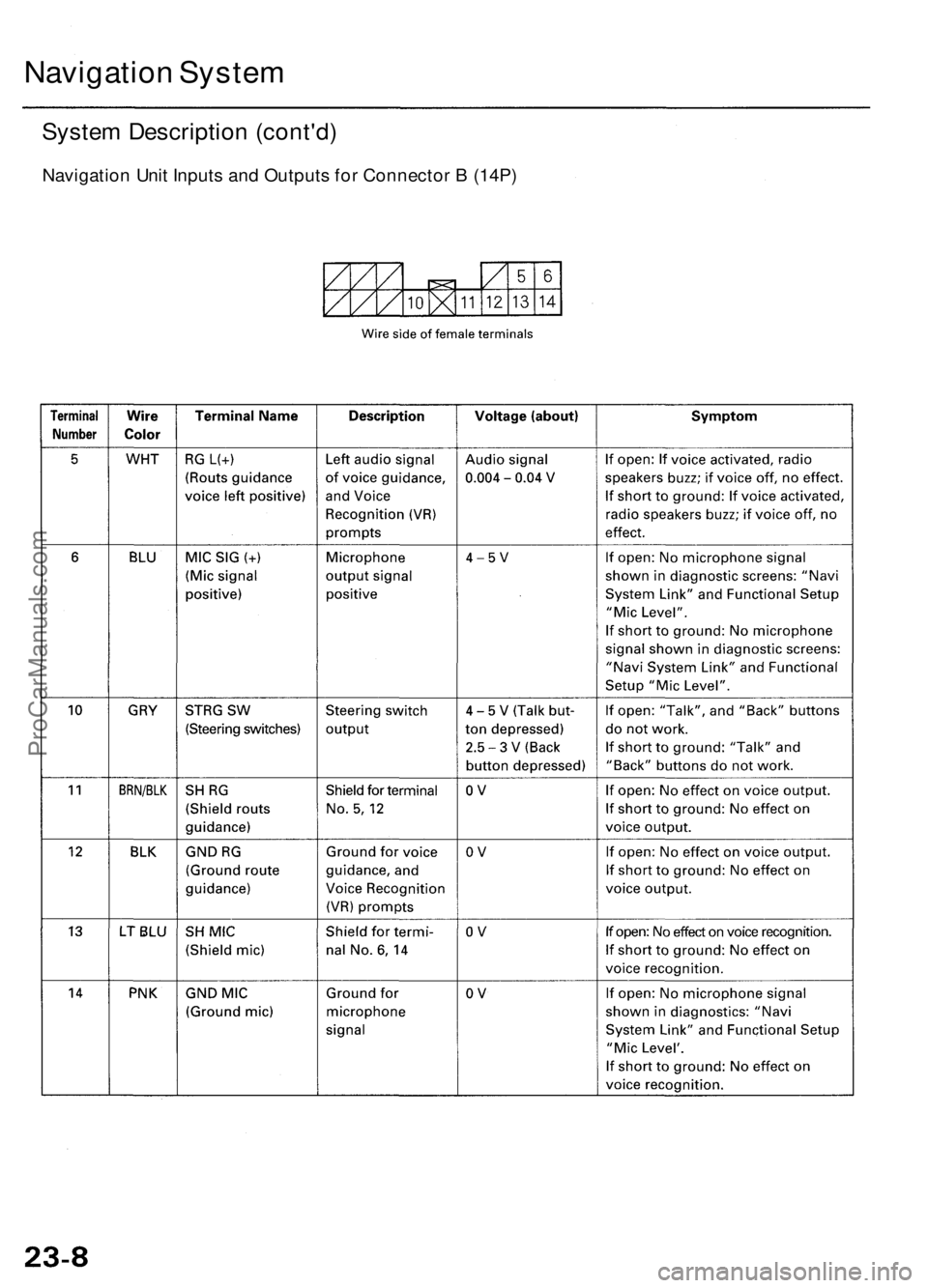
Navigation System
System Description (cont'd)
Navigation Unit Inputs and Outputs for Connector B (14P)ProCarManuals.com
Page 235 of 1954
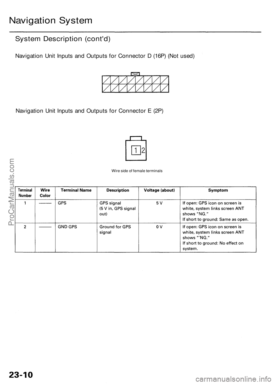
Navigation Syste m
System Descriptio n (cont'd )
Navigatio n Uni t Input s an d Output s fo r Connecto r D (16P ) (No t used )
Navigatio n Uni t Input s an d Output s fo r Connecto r E (2P )
Wire sid e o f femal e terminal s
ProCarManuals.com
Page 237 of 1954
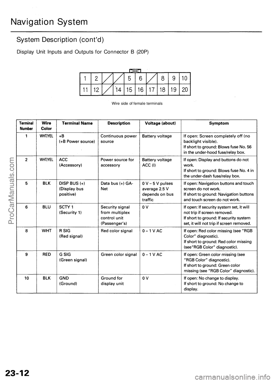
Navigation System
System Description (cont'd)
Display Unit Inputs and Outputs for Connector B (20P)
Wire side of female terminalsProCarManuals.com
Page 239 of 1954
Navigation System
System Description (cont'd)
Overview
The Acura Navigation System is a highly-sophisticated, hybrid locating system that uses satellites and a map database to
show you where you are and to help guide you to a desired destination.
The navigation system receives signals from the Global Positioning System (GPS), a network of 24 satellites in orbit
around the earth. By receiving signals from serveral of these satellites, the navigation system can determine the latitude,
longitude, and elevation of the vehicle. In addition, signals from the system's yaw rate sensor and the PCM (vehicle
speed pulse) enable the system to keep track of the vehicle's direction and speed of travel.
This hybrid system has advantages over a system that is either entirely self-contained or one that relies totally on the
GPS. For example, the self-contained portion of the system can keep track of vehicle position even when satellite signals
cannot be received. When the navigation system is on, the GPS can keep track of the vehicle position even when the vehi-
cle is transported by ferry.
The navigation system applies all this location, direction, and speed information to the maps and calculates a route to the
destination entered. As you drive to that destination, the system provides both visual and audio guidance.
This navigation system also has voice recognition that allows voice control of most of the navigation functions. The TALK
and BACK buttons on the steering wheel activate the voice control.
The illumination signal is used for two purposes. The display unit uses the signal to light up the hard buttons surrounding
the display. In addition the signal is used by the navigation unit to automatically switch from the "Day" to "Night" display
mode when the headlights are on. This automatic switching occurs only if the "Display" setting in setup screen 1 is set to
"AUTO". If the headlights are on and the customer has the dash light brightness control to "full bright," then this overrides
the "Night" mode.
The use of the audio speakers follows a hierarchy. The highest priority is the OnStar voice, followed by the navigation voice,
and finally the radio/CD. The audio unit enforces this hierarchy. The GA-Net bus is used to pass commands to mute the speak-
ers, and to disable the voice control system. Prior systems used dedicated wires to accomplish this function.
• If On-Star is in use, the audio unit passes a command on the GA-Net bus to the navigation unit to disable the voice control
system. The navigation unit then ignores the voice control switch, and temporarily ceases voice route guidance prompts.
• When the navigation system issues route guidance, the navigation unit uses the GA-Net bus to tell the audio unit to mute just
the front speakers. When the voice control system is being used (the TALK/BACK buttons), the navigation unit uses the GA-
Net bus to tell the audio unit to mute all speakers.ProCarManuals.com
Page 241 of 1954
System Description (cont'd)
Navigation Function
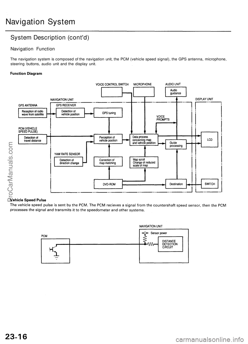
The navigation system is composed of the navigation unit, the PCM (vehicle speed signal), the GPS antenna, microphone,
steering buttons, audio unit and the display unit.
Navigation SystemProCarManuals.com