navigation system CADILLAC ESCALADE 2009 3.G Owner's Manual
[x] Cancel search | Manufacturer: CADILLAC, Model Year: 2009, Model line: ESCALADE, Model: CADILLAC ESCALADE 2009 3.GPages: 586, PDF Size: 4.47 MB
Page 294 of 586
Features and Controls
Using the Navigation System
This section presents basic information needed to
operate the navigation system.
Use the hard keys located on the navigation system
along with the available touch-sensitive screen buttons
on the navigation screen to operate the system.
SeeNavigation System Overview on page 4-2for more
information.
Once the vehicle is moving, various functions are
disabled to reduce driver distractions.
Hard Keys
The following hard keys are located on the navigation
system:
O/n(Power/Volume):Press to turn the system on
and off. Turn to increase or decrease the volume to
the audio system.
Press and hold for more than two seconds to turn off
the navigation system, the Rear Seat Entertainment
(RSE), and Rear Seat Audio (RSA). If the vehicle has
not been tuned off, the RSE and the RSA can be turned
back on by pressing this knob and continues play of
the last active source.
w(Tune):Turn to go to the next or previous radio
station or disc track or chapter. SeeNavigation Audio
System on page 4-59,CD Player on page 4-67,orDVD
Player on page 4-74for more information.
Z(DVD Map Disc Eject):Press to eject the DVD
map disc. This button is located next to the upper disc
slot. SeeMaps on page 4-14for more information.
M(Load):Press to load CDs or audio/video DVDs.
SeeCD Player on page 4-67orDVD Player on
page 4-74for more information.
Z(CD/DVD Eject):Press to eject CDs or audio/video
DVDs. This button is located under the load button.
SeeCD Player on page 4-67orDVD Player on
page 4-74for more information.
m(Tilt):Press up or down to tilt the screen.
AUDIO:Press access the full Audio screen to change
AM, FM, XM™ Satellite Radio Service (if equipped),
CD/DVD, and auxiliary input. See “Audio” under
Navigation Audio System on page 4-59for more
information.
FAV (Favorite):Press to access the preset stations.
See “Storing Radio Station Presets” underNavigation
Audio System on page 4-59for more information.
4-12
Page 295 of 586
5(Phone):Press to access calling through OnStar®.
SeeOnStar®System on page 2-52andBluetooth®
on page 3-73for more information.
e(Sound):Press to access the Sound screen to
adjust bass, midrange, treble, and Digital Signal
Processing (DSP). See “Sound Menu” underNavigation
Audio System on page 4-59for more information.
DEST (Destination):Press to access the Destination
Entry screen to plan a destination. SeeDestination
on page 4-24for more information.
CONFIG (Con�gure Menu):Press to adjust features
for sound, radio, navigation, and the display. See
Configure Menu on page 4-42for more information.
NAV (Navigation):Press to view your vehicle’s current
position on the map screen. Each press of this key
cycles through Full Map and the tab that displays the
current audio source (AM, FM, CD, etc.). Full Map
displays the screen in full map view. Selecting the audio
tab splits the screen between the map screen and the
current audio source screen menu. See “Audio”
underNavigation Audio System on page 4-59for
more information.
RPT (Navigation Repeat):Press to repeat the last
voice guidance prompt.
y©¨z(Seek): Press the seek arrows to seek
and scan radio stations, to seek tracks on a CD, and
to seek chapters on a DVD. SeeNavigation Audio
System on page 4-59,CD Player on page 4-67,
orDVD Player on page 4-74for more information.
Touch-Sensitive Screen Buttons
Touch-sensitive screen buttons are located on the
screen. When a screen button has been selected, a
beep sounds. Screen buttons are highlighted when
a feature is available.
Alpha-Numeric Keyboard
Letters of the alphabet, symbols, punctuation, and
numbers, when available, displays on the navigation
screen as an alpha or numeric keyboard. The alpha
keyboard displays when the system requires entry
of a city or street name.
All characters are touch-sensitive screen buttons.
Touch a character to select it.
A-Y (Accent Alphabet):Select to enter letters with
accent symbols. This button may toggle to A-Z.
A-Z (Alphabet):Select to enter letters from the
alphabet. This button may toggle to A-Y.
0-9 (Numbers):Select to enter numbers.
4-13
Page 296 of 586
U(Space):Select to enter a space between
characters or the words of a name.
Backspace:Select if an incorrect character has
been entered.
To make name entries easier, the system only highlights
the characters that can follow the last one entered.
For example, if a Z is entered, a T may not be available
for selection.
If a name does not display after entry, it may need to
be entered differently or the map DVD disc may
not contain that information. SeeDatabase Coverage
Explanations on page 4-59for more information.
Maps
This section includes basic information that you need to
know about the map database.
The maps are stored on a DVD. The United States,
Canada, and Puerto Rico are contained on one disc.
Detailed Areas
Road network attributes are contained in the map
database for detailed areas. Attributes include
information such as street names, street address, turn
restrictions, etc. A detailed area includes all major
highways, service roads, and residential roads. The
detailed areas include points of interest (POI) such as:
restaurants, airports, banks, hospitals, police stations,
gas stations, tourist attractions, historical monuments,
etc. The map database may not include data for newly
constructed areas or map database corrections that are
completed after the production of the disc. The navigation
system provides full route guidance in the detailed
map areas.
Limited Guidance Areas
Any area that is not classi�ed as detailed, is a limited
guidance area. Limited guidance streets are displayed
on the map but route guidance may not be given
on these streets. Some POI categories, such as the city
center POI category, and some street addresses are
included in the limited guidance areas.
The navigation system informs through voice prompts
when you are traveling into a limited guidance area
where route guidance is not available. The street maps
and the directional arrow displayed on the navigation
system can then be used to determine the remaining
route to your destination.
4-14
Page 297 of 586
Installing the DVD Map Disc
Your dealer/retailer may have installed the map DVD. If
the map DVD was not installed, do the following to load it:
1. Turn the ignition on.
2. Press
Oto turn the navigation system on.
3. Load the map DVD partway into the slot located
just below the screen. The system pulls it in.
4. If the Caution screen appears, touch the
OK screen button to agree.
DVD Map Disc Messages
If Disc Read Error appears on the display and/or the
map disc comes out, it could be for one of the following
reasons:
If the map disc was installed into the CD slot.
See “Installing the DVD Map Disc” previously.
It is very hot, when the temperature returns to
normal, the map disc should play.
You are driving on a very rough road. When the road
becomes smoother, the map disc should play.
The map disc is dirty, scratched, wet,
or upside down.
If any error occurs repeatedly or if an error cannot be
corrected, contact your dealer/retailer.
Ejecting the DVD Map Disc
Z
(DVD Map Disc Eject):Press to eject the
DVD map disc. This button is located next to the
upper disc slot.
Handling the DVD Map Disc
When handling the DVD map disc, be careful
of the following:
Handle the disc very carefully to avoid
contamination or �aws. Signals may not read out
properly if the disc gets contaminated or �awed.
If the disc gets soiled, use a soft cloth to gently wipe
it out from the center of the disc to the outside.
Do not use photographic record cleaner, solvents,
or other cleaners.
Do not use the disc to rest on while writing or
drawing using any writing utensil or attach a
seal to any of the sides or the disc.
Do not keep the disc in direct sunlight, high
temperatures, or humidity.
After using the disc, place it back into the
original case.
4-15
Page 298 of 586
Map Adjustments
The system lets you adjust the scale of view on the
map. Also, as you drive, the map scrolls automatically
based on the direction of travel.
Map Scales
+/−(Zoom In/Zoom Out):Touch the zoom in or out
screen buttons or the scale on the bar to change the level
of map detail. The scale appears on the screen once the
zoom in or zoom out screen buttons are selected. The
system adjusts the map accordingly. The scale of a map
can range from 1/32 mi. (50 m) to 256 mi. (400 km).
To change English or metric, seeDIC Operation and
Displays on page 3-46for more information.
Scrolling the Map
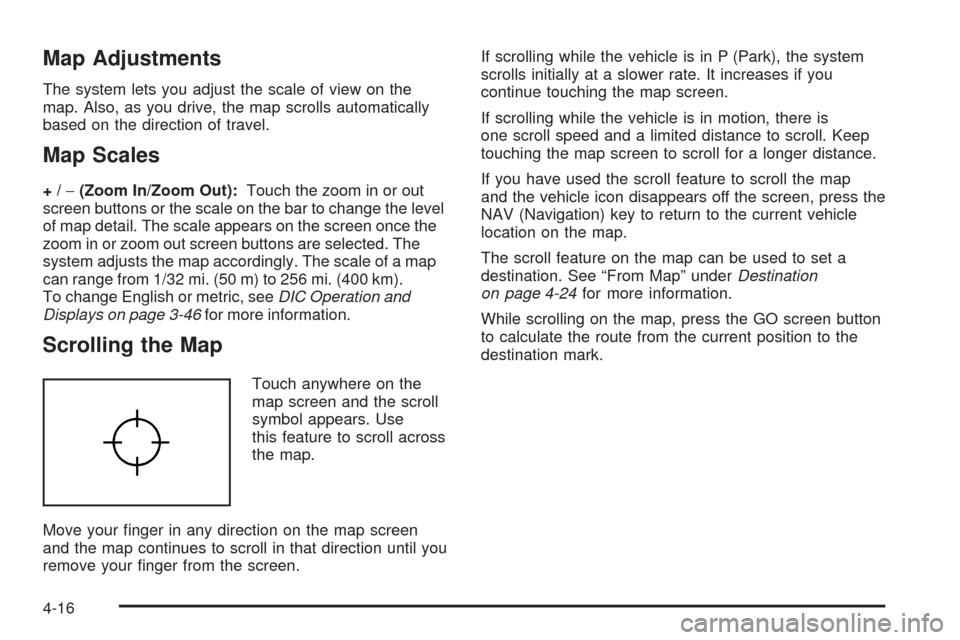
Touch anywhere on the
map screen and the scroll
symbol appears. Use
this feature to scroll across
the map.
Move your �nger in any direction on the map screen
and the map continues to scroll in that direction until you
remove your �nger from the screen.If scrolling while the vehicle is in P (Park), the system
scrolls initially at a slower rate. It increases if you
continue touching the map screen.
If scrolling while the vehicle is in motion, there is
one scroll speed and a limited distance to scroll. Keep
touching the map screen to scroll for a longer distance.
If you have used the scroll feature to scroll the map
and the vehicle icon disappears off the screen, press the
NAV (Navigation) key to return to the current vehicle
location on the map.
The scroll feature on the map can be used to set a
destination. See “From Map” underDestination
on page 4-24for more information.
While scrolling on the map, press the GO screen button
to calculate the route from the current position to the
destination mark.
4-16
Page 316 of 586
Map Destination Screen Functions
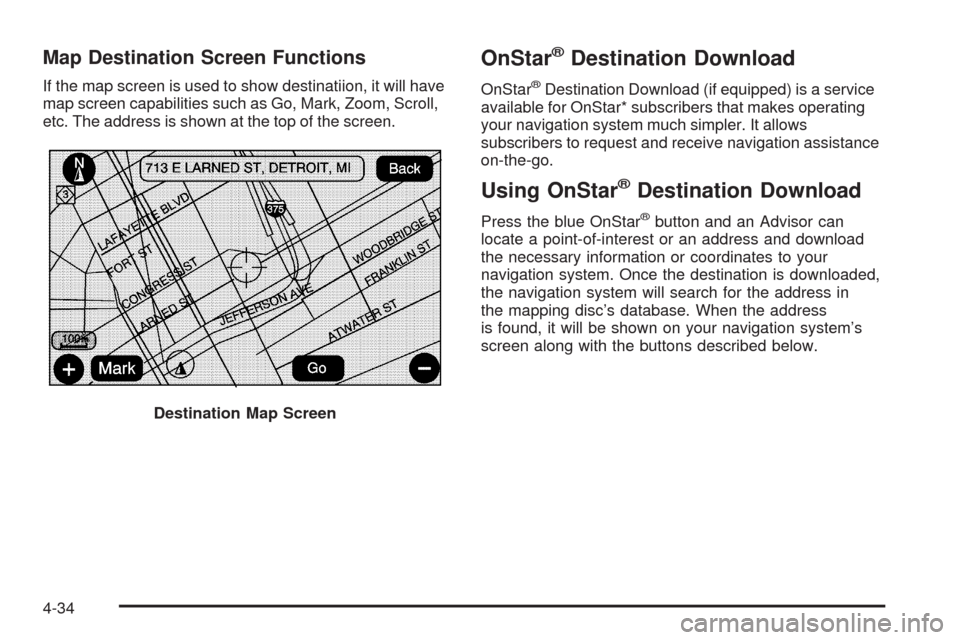
If the map screen is used to show destinatiion, it will have
map screen capabilities such as Go, Mark, Zoom, Scroll,
etc. The address is shown at the top of the screen.
OnStar®Destination Download
OnStar®Destination Download (if equipped) is a service
available for OnStar* subscribers that makes operating
your navigation system much simpler. It allows
subscribers to request and receive navigation assistance
on-the-go.
Using OnStar®Destination Download
Press the blue OnStar®button and an Advisor can
locate a point-of-interest or an address and download
the necessary information or coordinates to your
navigation system. Once the destination is downloaded,
the navigation system will search for the address in
the mapping disc’s database. When the address
is found, it will be shown on your navigation system’s
screen along with the buttons described below.
Destination Map Screen
4-34
Page 317 of 586
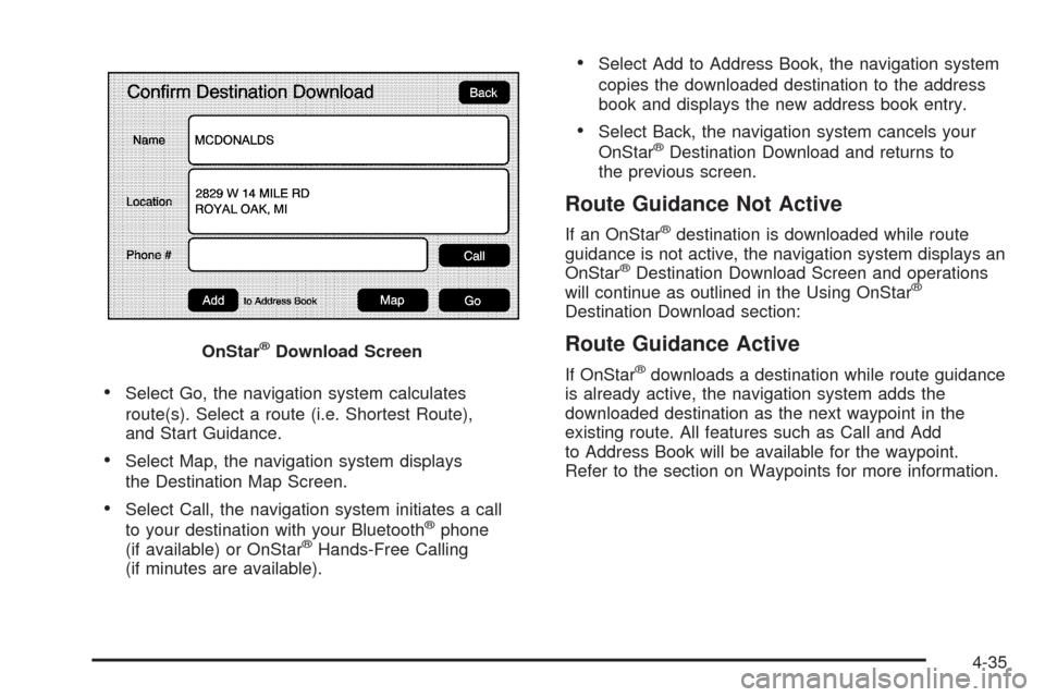
Select Go, the navigation system calculates
route(s). Select a route (i.e. Shortest Route),
and Start Guidance.
Select Map, the navigation system displays
the Destination Map Screen.
Select Call, the navigation system initiates a call
to your destination with your Bluetooth®phone
(if available) or OnStar®Hands-Free Calling
(if minutes are available).
Select Add to Address Book, the navigation system
copies the downloaded destination to the address
book and displays the new address book entry.
Select Back, the navigation system cancels your
OnStar®Destination Download and returns to
the previous screen.
Route Guidance Not Active
If an OnStar®destination is downloaded while route
guidance is not active, the navigation system displays an
OnStar
®Destination Download Screen and operations
will continue as outlined in the Using OnStar®
Destination Download section:
Route Guidance Active
If OnStar®downloads a destination while route guidance
is already active, the navigation system adds the
downloaded destination as the next waypoint in the
existing route. All features such as Call and Add
to Address Book will be available for the waypoint.
Refer to the section on Waypoints for more information. OnStar
®Download Screen
4-35
Page 318 of 586
Previous Destinations
Previous OnStar®Destination Downloads are saved
under Previous Destinations in the navigation
system where they can be accessed or saved
to the address book.
Important Notes regarding OnStar
®Destination
Download:
If the navigation system is turned off when the
destination download is attempted, the navigation
system will automatically turn on and display
the OnStar
®Destination Download Screen. The
radio will remain on after the download occurs.
If OnStar®downloads a destination and the address
is not found in the mapping disc’s database and
routing by coordinates is not available, the Go and
Map buttons gray out and routing will not be
available. Press the blue OnStar
®button for further
assistance.
The Call button grays out when there is no phone
number available for your destination and while
connected to OnStar
®.
Map Destination Screen Functions
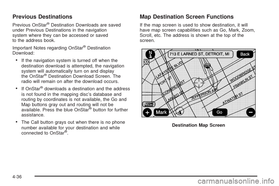
If the map screen is used to show destination, it will
have map screen capabilities such as Go, Mark, Zoom,
Scroll, etc. The address is shown at the top of the
screen.
Destination Map Screen
4-36
Page 324 of 586
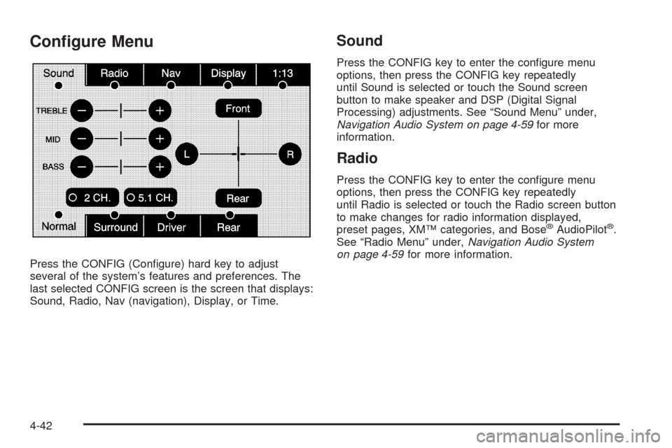
Con�gure Menu
Press the CONFIG (Con�gure) hard key to adjust
several of the system’s features and preferences. The
last selected CONFIG screen is the screen that displays:
Sound, Radio, Nav (navigation), Display, or Time.
Sound
Press the CONFIG key to enter the con�gure menu
options, then press the CONFIG key repeatedly
until Sound is selected or touch the Sound screen
button to make speaker and DSP (Digital Signal
Processing) adjustments. See “Sound Menu” under,
Navigation Audio System on page 4-59for more
information.
Radio
Press the CONFIG key to enter the con�gure menu
options, then press the CONFIG key repeatedly
until Radio is selected or touch the Radio screen button
to make changes for radio information displayed,
preset pages, XM™ categories, and Bose
®AudioPilot®.
See “Radio Menu” under,Navigation Audio System
on page 4-59for more information.
4-42
Page 325 of 586
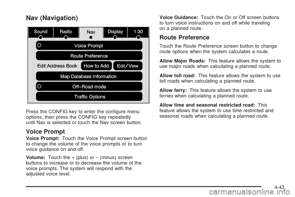
Nav (Navigation)
Press the CONFIG key to enter the con�gure menu
options, then press the CONFIG key repeatedly
until Nav is selected or touch the Nav screen button.
Voice Prompt
Voice Prompt:Touch the Voice Prompt screen button
to change the volume of the voice prompts or to turn
voice guidance on and off.
Volume:Touch the + (plus) or−(minus) screen
buttons to increase or to decrease the volume of the
voice prompts. The system will respond with the
adjusted voice level.Voice Guidance:Touch the On or Off screen buttons
to turn voice instructions on and off while traveling
on a planned route.
Route Preference
Touch the Route Preference screen button to change
route options when the system calculates a route.
Allow Major Roads:This feature allows the system to
use major roads when calculating a planned route.
Allow toll road:This feature allows the system to use
toll roads when calculating a planned route.
Allow ferry:This feature allows the system to use
ferries when calculating a planned route.
Allow time and seasonal restricted road:This
feature allows the system to use time restricted and
seasonal roads when calculating a planned route.
4-43