display Citroen C4 AIRCROSS RHD 2017 1.G Service Manual
[x] Cancel search | Manufacturer: CITROEN, Model Year: 2017, Model line: C4 AIRCROSS RHD, Model: Citroen C4 AIRCROSS RHD 2017 1.GPages: 368, PDF Size: 11.44 MB
Page 180 of 368
178
Advice on driving when towing
Distribution of loads
F Distribute the load in the trailer so that the heaviest items are as close as possible to
the axle and the nose weight approaches
the maximum permitted without
exceeding
it.
Air density decreases with altitude,
thus
reducing engine per formance. Above
1
000 metres, the maximum towing load must
be reduced by 10
% of the GTW and so on for
every 1
000 metres of altitude.
For more information on Petrol weights or
Diesel weights and in particular the towed
loads which apply to your vehicle, refer to the
corresponding section.
Side wind
F Take into account the increased sensitivity to side wind.
Cooling
Towing a trailer on a slope increases the
temperature of the coolant.
As the fan is electrically controlled, its cooling
capacity is not dependent on the engine speed.
F
T
o lower the engine speed, reduce your
speed.
The maximum towed load on a long slope
depends on the gradient and the exterior
temperature.
In all cases, pay attention to the coolant
temperature.
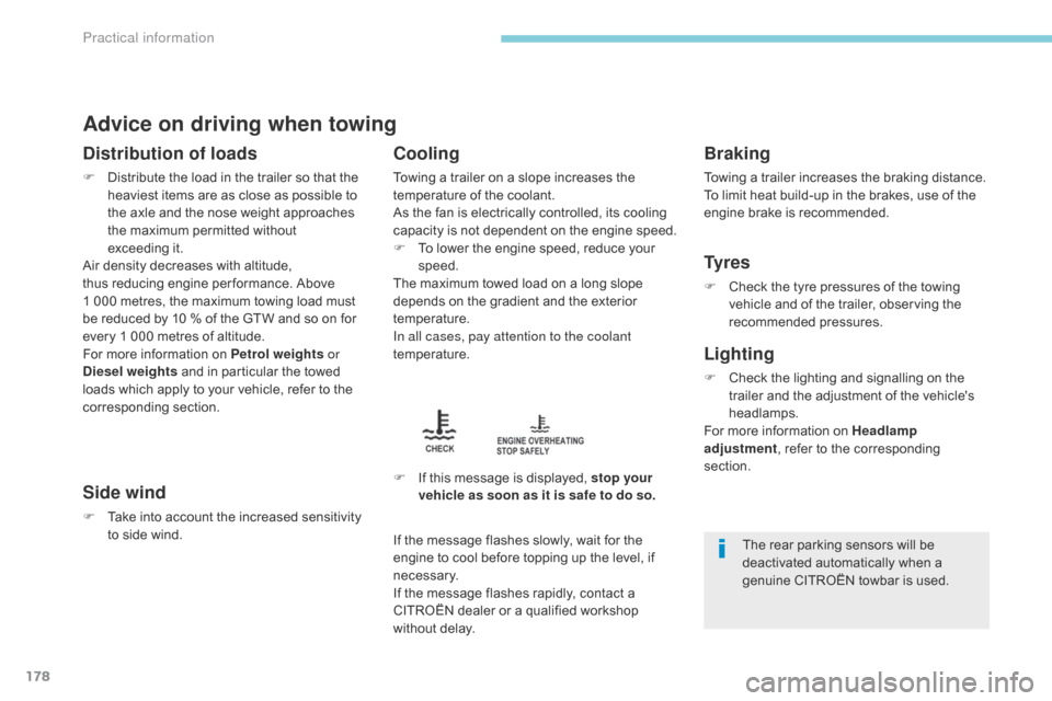
F
I
f this message is displayed, stop your
vehicle as soon as it is safe to do so.
Braking
Towing a trailer increases the braking distance.
To limit heat build-up in the brakes, use of the
engine brake is recommended.
Ty r e s
F Check the tyre pressures of the towing vehicle and of the trailer, observing the
recommended pressures.
Lighting
F Check the lighting and signalling on the trailer and the adjustment of the vehicle's
headlamps.
For more information on Headlamp
adjustment , refer to the corresponding
section.
If the message flashes slowly, wait for the
engine to cool before topping up the level, if
necessary.
If the message flashes rapidly, contact a
CITROËN dealer or a qualified workshop
without delay.
The rear parking sensors will be
deactivated automatically when a
genuine CITROËN towbar is used.
Practical information
Page 187 of 368
185
Avoid prolonged contact of used oil or
fluids with the skin.
Most of these fluids are harmful to
health or indeed very corrosive.
Do not discard used oil or fluids into
sewers or onto the ground.
Take used oil to a CITROËN dealer or
a qualified workshop (France) or to an
authorised waste disposal site.
Used products
To p p i n g u p
The reservoir must be topped up without delay
by a CITROËN dealer or a qualified workshop.
Additive level (1.6 HDi 115 Diesel
versions with particle filter)
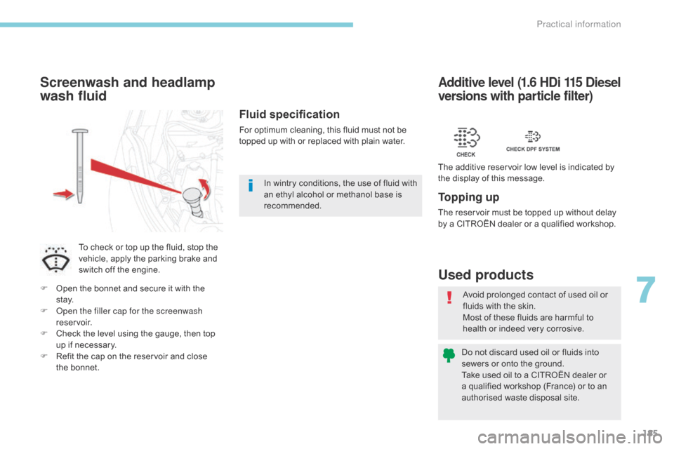
The additive reservoir low level is indicated by
the display of this message.
Fluid specification
For optimum cleaning, this fluid must not be
topped up with or replaced with plain water.
Screenwash and headlamp
wash fluid
To check or top up the fluid, stop the
vehicle, apply the parking brake and
switch off the engine.
F
O
pen the bonnet and secure it with the
st ay.
F
O
pen the filler cap for the screenwash
reservoir.
F
C
heck the level using the gauge, then top
up if necessary.
F
R
efit the cap on the reservoir and close
the
bonnet. In wintry conditions, the use of fluid with
an ethyl alcohol or methanol base is
recommended.
7
Practical information
Page 237 of 368
235
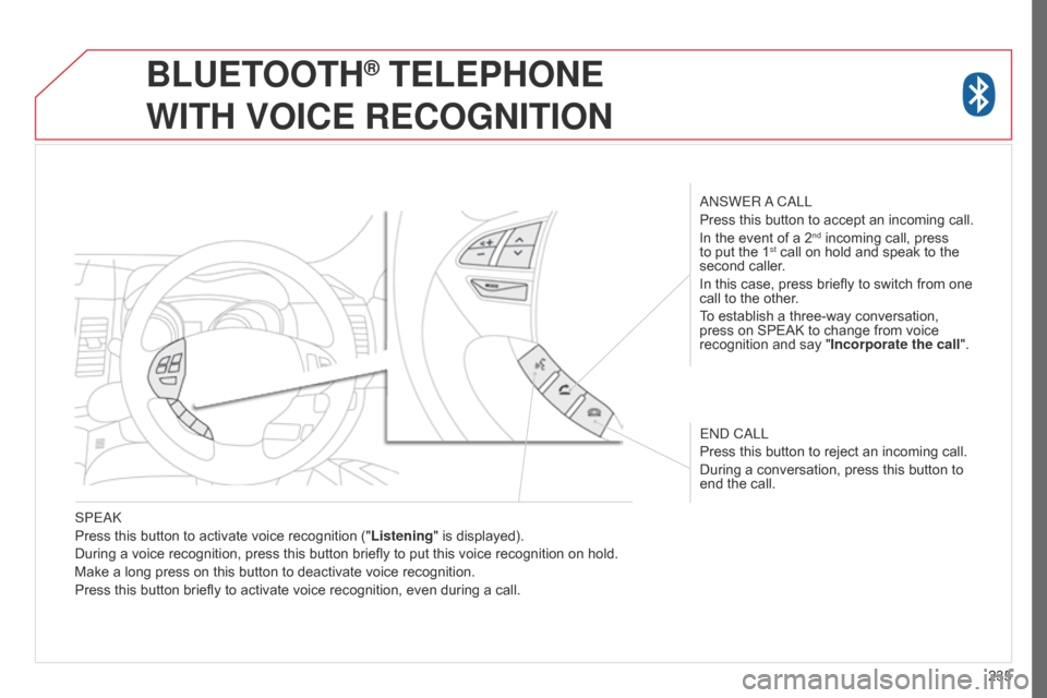
SPEAK
Press this button to activate voice recognition ("
Listening" is displayed).
During a voice recognition, press this button briefly to put this voice recognition on hold.
Make a long press on this button to deactivate voice recognition.
Press this button briefly to activate voice recognition, even during a call. ANSWER A CALL
Press this button to accept an incoming call.
In the event of a 2
nd incoming call, press
to put the 1st call on hold and speak to the
second caller.
In this case, press briefly to switch from one
call to the other.
To establish a three-way conversation,
press on SPEAK to change from voice
recognition and say " Incorporate the call".
END CALL
Press this button to reject an incoming call.
During a conversation, press this button to
end the call.
BLUETOOTH® TELEPHONE
WITH
VOICE
RECOGNITION
Page 253 of 368
03
251
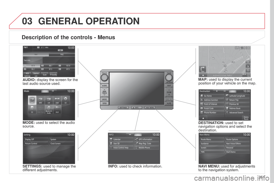
Description of the controls - Menus
SETTINGS: used to manage the
different adjustments.DESTINATION: used to set
navigation options and select the
destination.
NAVI MENU: used for adjustments
to the navigation system.
MODE: used to select the audio
source.
INFO: used to check information.
AUDIO: display the screen for the
last audio source used.
MAP: used to display the current
position of your vehicle on the map.
GENERAL
OPERATION
Page 255 of 368
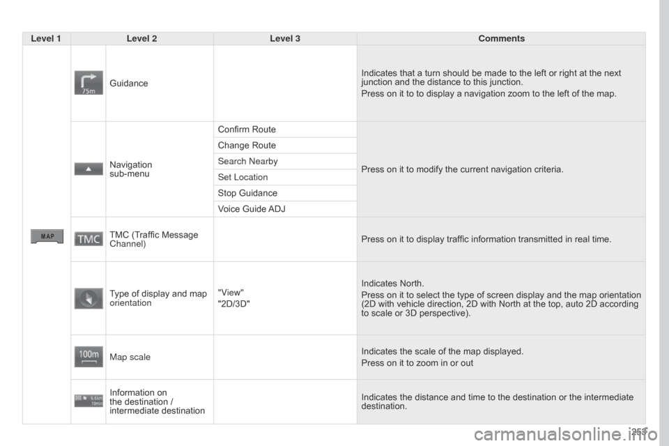
253
Level 1
Level 2 Level 3 Comments
Guidance Indicates that a turn should be made to the left or right at the next
junction and the distance to this junction.
Press on it to to display a navigation zoom to the left of the map.
Navigation
sub-menu Confirm Route
Press on it to modify the current navigation criteria.
Change Route
Search Nearby
Set Location
Stop Guidance
Voice Guide ADJ
TMC (Traffic Message
Channel) Press on it to display traffic information transmitted in real time.
Type of display and map
orientation "View"
"2D/3D" Indicates North.
Press on it to select the type of screen display and the map orientation
(2D with vehicle direction, 2D with North at the top, auto 2D according
to scale or 3D perspective).
Map scale Indicates the scale of the map displayed.
Press on it to zoom in or out
Information on
the destination /
intermediate destination Indicates the distance and time to the destination or the intermediate
destination.
Page 259 of 368
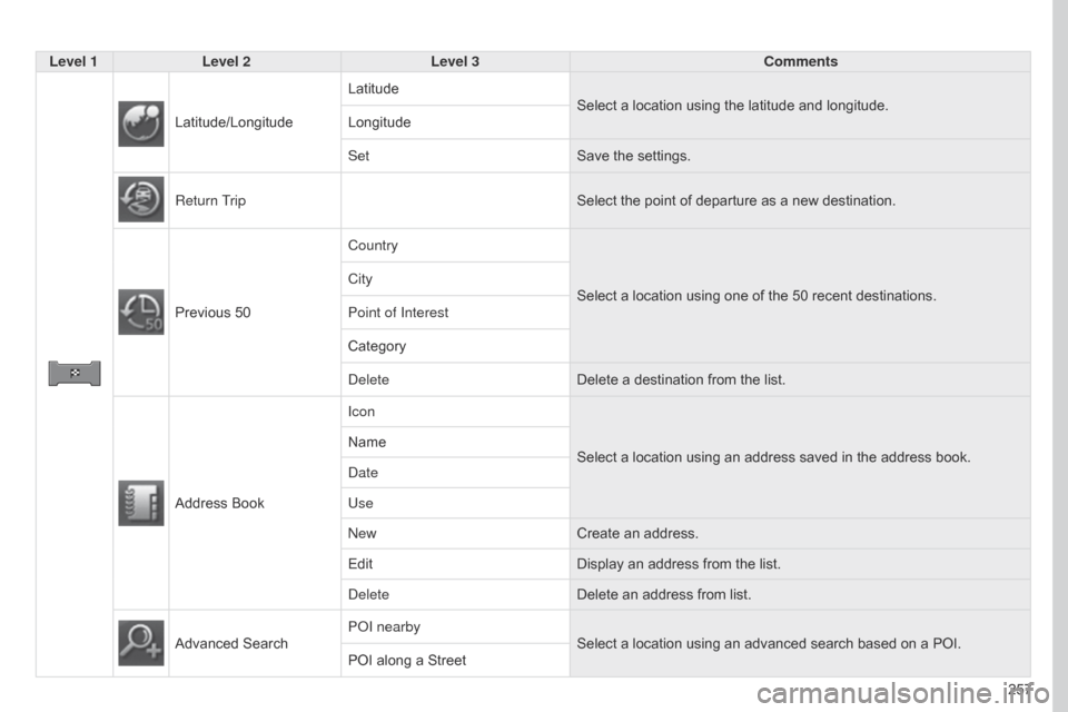
257
Level 1
Level 2 Level 3 Comments
Latitude/Longitude Latitude
Select a location using the latitude and longitude.
Longitude
Set Save the settings.
Return Trip Select the point of departure as a new destination.
Previous 50 Country
Select a location using one of the 50 recent
destinations.
City
Point of Interest
Category
Delete
Delete a destination from the list.
Address Book Icon
Select a location using an address saved in the address book.
Name
Date
Use
New
Create an address.
Edit Display an address from the list.
Delete Delete an address from list.
Advanced Search POI nearby
Select a location using an advanced search based on a POI.
POI along a Street
Page 261 of 368
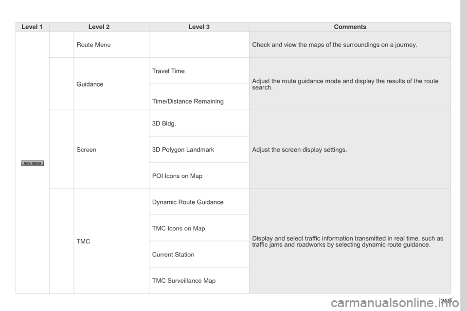
259
Level 1
Level 2 Level 3 Comments
Route Menu Check and view the maps of the surroundings on a journey.
Guidance Travel Time
Adjust the route guidance mode and display the results of the route
search.
Time/Distance Remaining
Screen 3D Bldg.
Adjust the screen display settings.
3D Polygon Landmark
POI Icons on Map
TMC Dynamic Route Guidance
Display and select traffic information transmitted in real time, such as
traffic jams and roadworks by selecting dynamic route guidance.
TMC Icons on Map
Current Station
TMC Surveillance Map
Page 264 of 368
04
262The satellite navigation system guides the driver to the destination
set in accordance with a chosen route.
Initially, it searches for the destination required by the user, then
it calculates the route and finally it provides the visual and vocal
guidance instructions.
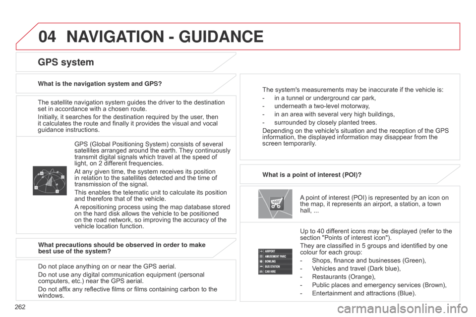
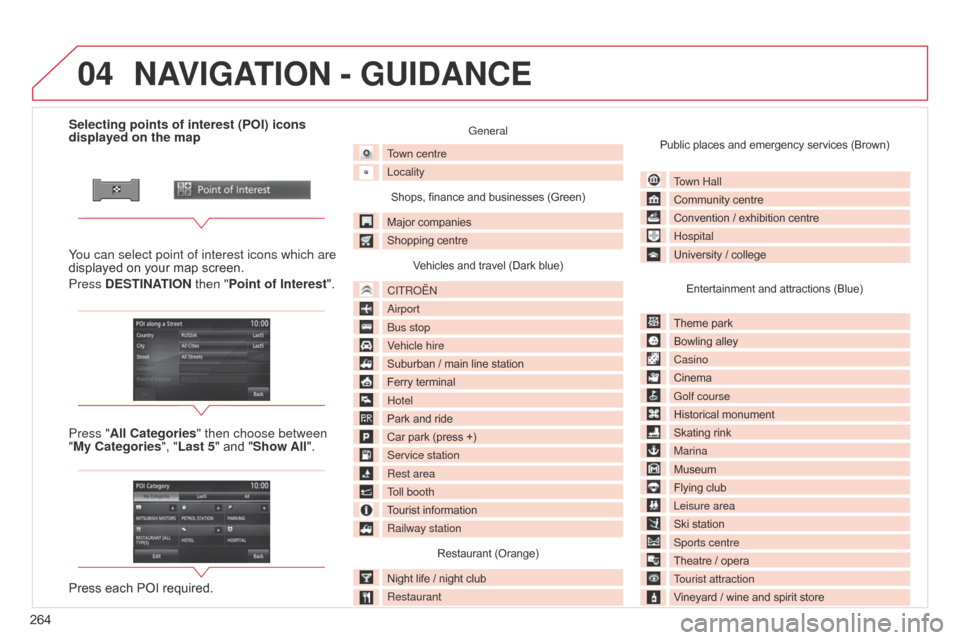
A point of interest (POI) is represented by an icon on
the map, it represents an airport, a station, a town
hall, ...
What is a point of interest (POI)?
Up to 40 different icons may be displayed (refer to the
section "Points of interest icon").
They are classified in 5 groups and identified by one
colour for each group:
-
Shops, finance and businesses (Green),
-
V
ehicles and travel (Dark blue),
-
Restaurants (Orange),
-
Public places and emergency services (Brown),
-
Entertainment and attractions (Blue).
GPS (Global Positioning System) consists of several
satellites arranged around the earth.
They continuously
transmit digital signals which travel at the speed of
light, on 2 different frequencies.
At any given time, the system receives its position
in relation to the satellites detected and the time of
transmission of the signal.
This enables the telematic unit to calculate its position
and therefore that of the vehicle.
A repositioning process using the map database stored
on the hard disk allows the vehicle to be positioned
on the road network, so improving the accuracy of the
vehicle location function.
GPS system
What is the navigation system and GPS? The system's measurements may be inaccurate if the vehicle is:
-
in a tunnel or underground car park,
-
underneath a two-level motorway
,
-
in an area with several very high buildings,
-
surrounded by closely planted trees.
Depending on the vehicle's situation and the reception of the GPS
information, the displayed information may disappear from the
screen temporarily
.
What precautions should be observed in order to make
best use of the system?
Do not place anything on or near the GPS aerial.
Do not use any digital communication equipment (personal
computers, etc.) near the GPS aerial.
Do not affix any reflective films or films containing carbon to the
windows.
NAVIGATION - GUIDANCE
Page 266 of 368
04
264Selecting points of interest (POI) icons
displayed on the map
You can select point of interest icons which are
displayed on your map screen.
Press DESTINATION then "Point of Interest ".
Press "All Categories" then choose between
"My Categories", "Last 5" and "Show All".
Press each POI required.
General
Town centre
Locality
Shops, finance and businesses (Green)
Major companies
Shopping centre Vehicles and travel (Dark blue)
CITROËN
Airport
Bus stop
Vehicle hire
Suburban / main line station
Ferry terminal
Hotel
Park and ride
Car park (press +)
Service station
Rest area
Toll booth
Tourist information
Railway station Restaurant (Orange)
Night life / night club
Restaurant Public places and emergency services (Brown)
Town Hall
Community centre
Convention / exhibition centre
Hospital
University / collegeEntertainment and attractions (Blue)
Theme park
Bowling alley
Casino
Cinema
Golf course
Historical monument
Skating rink
Marina
Museum
Flying club
Leisure area
Ski station
Sports centre
Theatre / opera
Tourist attraction
Vineyard / wine and spirit store
NAVIGATION - GUIDANCE
Page 267 of 368
04
265
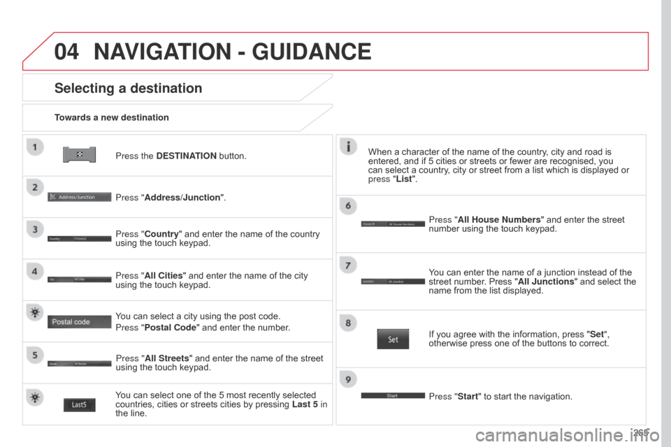
Press the DESTINATION button.
Towards a new destination
Selecting a destination
Press "Address/Junction".
Press "Country" and enter the name of the country
using the touch keypad.
You can select one of the 5 most recently selected
countries, cities or streets cities by pressing
Last 5 in
the line. Press "All Cities" and enter the name of the city
using the touch keypad.
Press "All Streets" and enter the name of the street
using the touch keypad. Press "All House Numbers" and enter the street
number using the touch keypad.
If you agree with the information, press "
Set",
otherwise press one of the buttons to correct.
Press "Start" to start the navigation. You can enter the name of a junction instead of the
street number. Press "All Junctions " and select the
name from the list displayed.
When a character of the name of the country, city and road is
entered, and if 5 cities or streets or fewer are recognised, you
can select a country, city or street from a list which is displayed or
press
"List".
You can select a city using the post code.
Press "Postal Code" and enter the number.
NAVIGATION - GUIDANCE