display Citroen C4 CACTUS 2015 1.G Repair Manual
[x] Cancel search | Manufacturer: CITROEN, Model Year: 2015, Model line: C4 CACTUS, Model: Citroen C4 CACTUS 2015 1.GPages: 326, PDF Size: 8.56 MB
Page 260 of 326
05
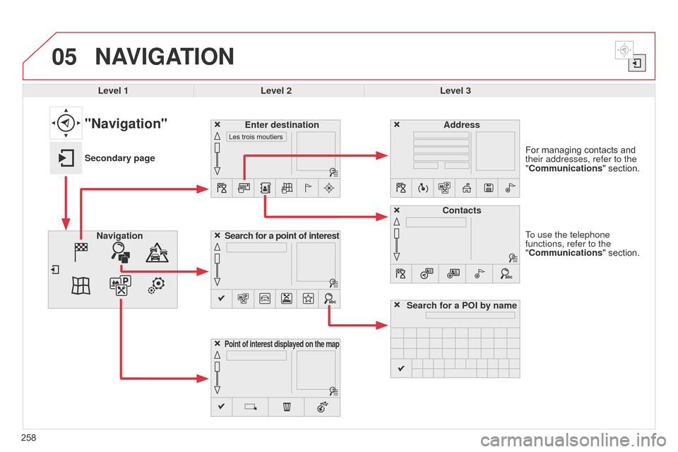
258To use the telephone
functions, refer to the
"Communications"ô section. For ô managing ô contacts ô and ô
their addresses, refer to the
"
Communications" ô section.
NAVIGATION
Search for a point of interest
Navigation Address
Enter destination
Contacts
Point of interest displayed on the map
Level 1Level 2 Level 3
"Navigation"
Secondary page
Search for a POI by name
Page 261 of 326
259
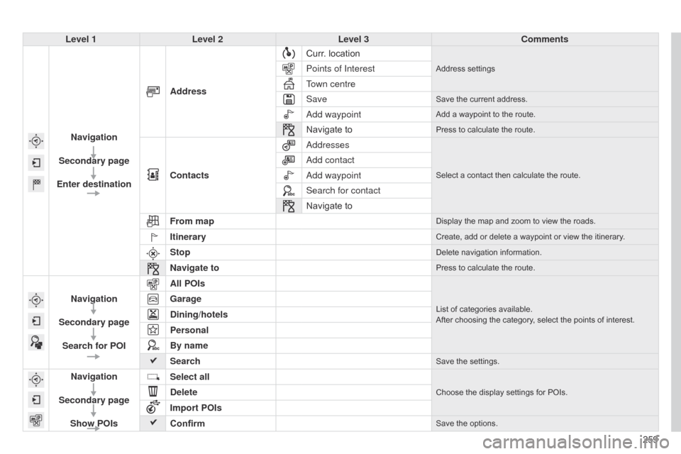
Level 1
Level 2 Level 3 Comments
Navigation
Secondary page
Enter destination Address
Curr.
ô
location
Addressô settingsPoints of Interest
Town centre
Save
Saveô theô currentô address.
add waypointAddô aô waypointô toô theô route.
Navigateô toPressô toô calculateô theô route.
Contacts
a
ddressesSelectô aô contactô thenô calculateô theô route.
add contact
a
dd waypoint
Search for contact
Navigate
ô to
From map
Displayô theô mapô andô zoomô toô viewô theô roads.
ItineraryCreate,ô addô orô deleteô aô waypointô orô viewô theô itinerary.
StopDeleteô navigationô information.
Navigate toPressô toô calculateô theô route.
Navigation
Secondary page Search for POI All POIsListô ofô categoriesô available.
After ô choosing ô the ô category, ô select ô the ô points ô of ô interest.Garage
Dining/hotels
Personal
By name
Search
Saveô theô settings.
Navigation
Secondary page Show POIs Select all
Chooseô theô displayô settingsô forô POIs.Delete
Import POIs
Confirm
Saveô theô options.
Page 263 of 326
261
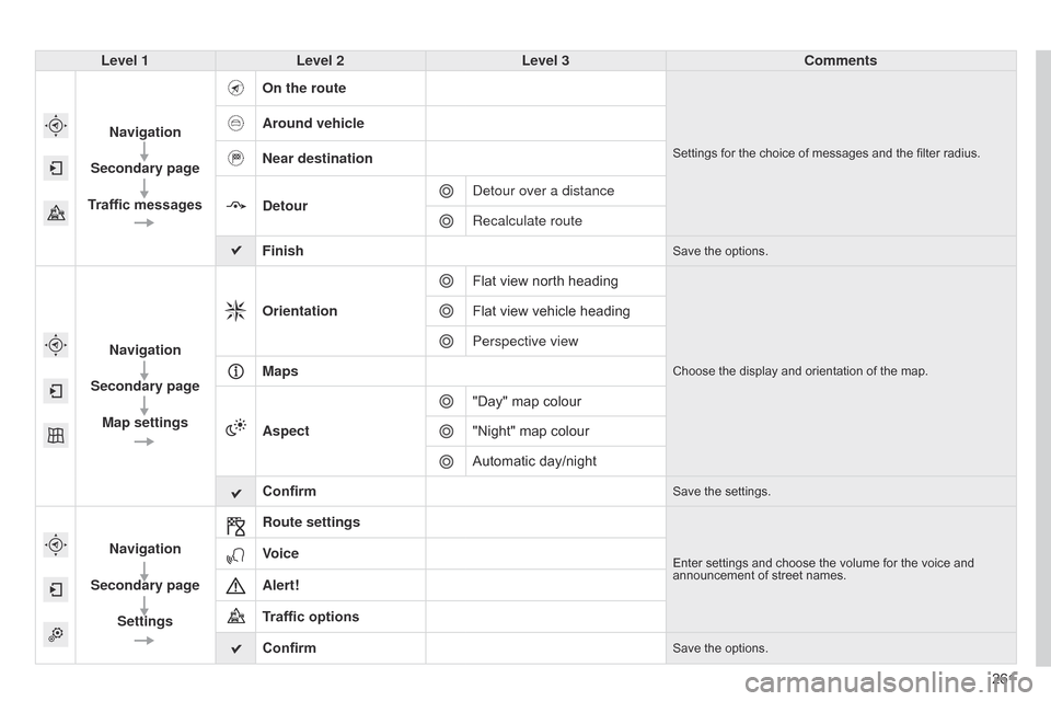
Level 1
Level 2 Level 3 Comments
Navigation
Secondary page
Traffic messages On the route
Settingsô forô theô choiceô ofô messagesô andô theô filterô radius.
Around vehicle
Near destination
Detour
d
etour over a distance
Recalculate route
Finish
Saveô theô options.
Navigation
Secondary page Map settings Orientation
Flat ô view ô north ô heading
Chooseô theô displayô andô orientationô ofô theô map.
Flatô viewô vehicleô heading
Perspective view
Maps
Aspect "Day"
ô map ô colour
"Night"
ô map ô colour
Automatic
ô day/night
Confirm
Saveô theô settings.
Navigation
Secondary page Settings Route settingsEnterô settingsô andô chooseô theô volumeô forô theô voiceô andô announcement
ô of ô street ô names.Voice
Alert!
Traffic options
Confirm
Saveô theô options.
Page 264 of 326
05
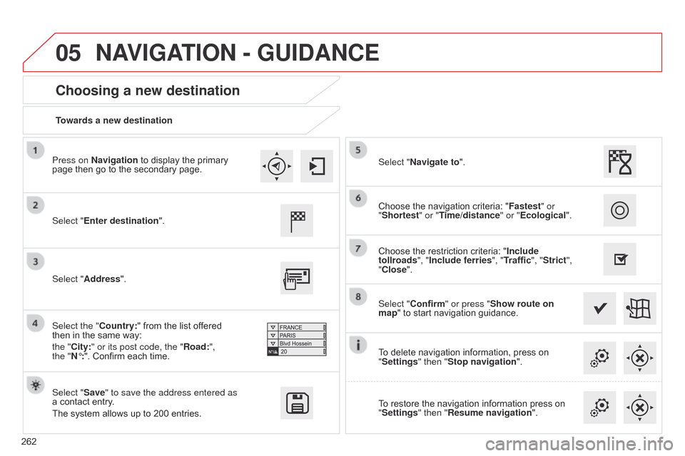
262Towards a new destination
Choosing a new destination
Select "Enter destination".
Select "Save" to save the address entered as
aô contact
ô entry.
The
ô system ô allows ô up ô to ô 200 ô entries. Select "Confirm" or press "Show route on
map"
ô to ô start ô navigation ô guidance.
Select "Address".
Select the "Country:"
ô from ô the ô list ô offered ô
thenô in
ô the ô same ô way: ô
the "
City:" or its post code, the "Road:",
the
"Nô¯:". ô Confirm ô each ô time. Select "Navigate to".
Choose
ô the ô restriction ô criteria: ô "Include
tollroads", "Include ferries", "Traffic", "Strict",
"Close". Choose ô the ô navigation ô criteria: ô "
Fastest" or
"Shortest" or "Time/distance" or "Ecological ".
To ô delete ô navigation ô information, ô press ô on ô
"
Settings" then "Stop navigation".
To
ô restore ô the ô navigation ô information ô press ô on ô
"
Settings" then "Resume navigation".
Press on Navigation
ô to ô display ô the ô primary ô
page
ô then ô go ô to ô the ô secondary ô page.
NAVIGATION - GUIDANCE
Page 265 of 326
05
263
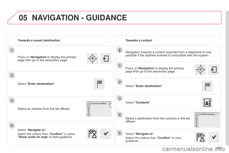
Towards a recent destination
Towards a contact
Navigation
ô
towards
ô
a
ô
contact
ô
imported
ô
from
ô
a
ô
telephone
ô
is
ô
only
ô
possible
ô
if
ô
the
ô
address
ô
entered
ô
is
ô
compatible
ô
with
ô
the
ô
system.
Select "Enter destination".
Select
ô
an
ô
address
ô
from
ô
the
ô
list
ô
offered.
Select "Enter destination".
Select "Contacts".
Select
ô
a
ô
destination
ô
from
ô
the
ô
contacts
ô
in
ô
the
ô
list
ô
of
fered.
Select "Navigate to".
Select the criteria then "Confirm" to start
guidance.
Select "Navigate to".
Select the criteria then "Confirm" or press
"Show route on map
"
ô
to
ô
start
ô
guidance.
Press on Navigation
ô
to
ô
display
ô
the
ô
primary
ô
page
ô
then
ô
go
ô
to
ô
the
ô
secondary
ô
page.
Press on Navigation
ô
to
ô
display
ô
the
ô
primary
ô
page
ô
then
ô
go
ô
to
ô
the
ô
secondary
ô
page.
NAVIGATION - GUIDANCE
Page 266 of 326
05
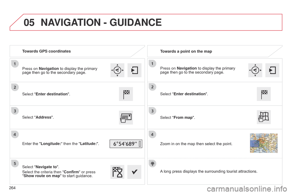
Towards GPS coordinatesTowards a point on the map
Select "Enter destination".
Select "Address".
Enter
ô the ô "Longitude: " then the "Latitude:".
Select "Navigate to".
Select the criteria then "Confirm" or press
"Show route on map "
ô to ô start ô guidance. Select "Enter destination".
Select "From map".
Zoom
ô in ô on ô the ô map ô then ô select ô the ô point.
Press on Navigation
ô to ô display ô the ô primary ô
page
ô then ô go ô to ô the ô secondary ô page. Press on Navigation
ô to ô display ô the ô primary ô
page
ô then ô go ô to ô the ô secondary ô page.
A
ô
long ô press ô displays ô the ô surrounding ô tourist ô attractions.
NAVIGATION - GUIDANCE
264
Page 267 of 326
05
265
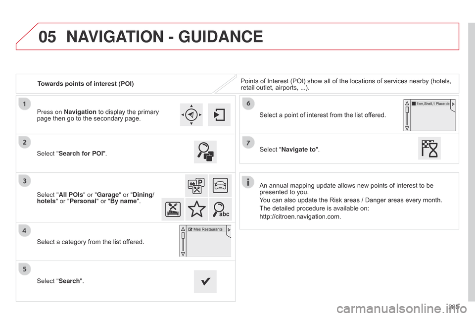
Towards points of interest (POI)
Points
ô
of
ô
Interest
ô
(POI)
ô
show
ô
all
ô
of
ô
the
ô
locations
ô
of
ô
services
ô
nearby
ô
(hotels, ô
retail
ô
outlet,
ô
airports,
ô
...).
Select "Search for POI".
Select "All POIs" or "Garage" or "Dining/
hotels" or "Personal" or "By name".
Select
ô
a
ô
category
ô
from
ô
the
ô
list
ô
offered.
Select "Search". Select
ô
a
ô
point
ô
of
ô
interest
ô
from
ô
the
ô
list
ô
offered.
Select "Navigate to".
Press on Navigation
ô
to
ô
display
ô
the
ô
primary
ô
page
ô
then
ô
go
ô
to
ô
the
ô
secondary
ô
page.
NAVIGATION - GUIDANCE
Anô annualô mappingô updateô allowsô newô pointsô ofô interestô toô beô presented
ô to ô you.
You
ô can ô also ô update ô the ô Risk ô areas ô / ô Danger ô areas ô every ô month.
The
ô detailed ô procedure ô is ô available ô on:
http://citroen.navigation.com.
Page 268 of 326
05
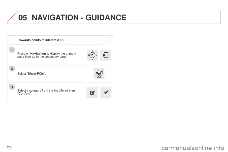
266Press on Navigation ô to ô display ô the ô primary ô
page
ô then ô go ô to ô the ô secondary ô page.
Select ô a ô category ô from ô the ô list ô offered ô then ô
"
Confirm".
Select "Show POIs
".
Towards points of interest (POI)
NAVIGATION - GUIDANCE
Page 269 of 326
05
267
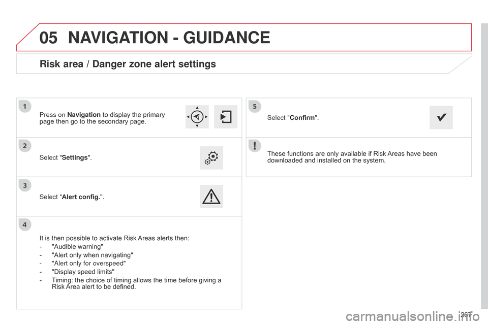
These
ô
functions
ô
are
ô
only
ô
available
ô
if
ô
Risk
ô
Areas
ô
have
ô
been
ô
downloaded
ô
and
ô
installed
ô
on
ô
the
ô
system.
Select "Settings".
Select "Alert config.".
Risk area / Danger zone alert settings
Itô isô thenô possibleô toô activateô Riskô Areas
ô alerts ô then:
- ô
"Audible
ô warning"
-
ô
"Alert
ô only ô when ô navigating"
-
"
a lert only for overspeed"
-
ô
"Display
ô speed ô limits"
-
ô
T
iming: ô the ô choice ô of ô timing ô allows ô the ô time ô before ô giving ô a ô
Riskô
Area ô alert ô to ô be ô defined. Select "Confirm".
Press on Navigation ô to ô display ô the ô primary ô
page
ô then ô go ô to ô the ô secondary ô page.
NAVIGATION - GUIDANCE
Page 270 of 326
05
268
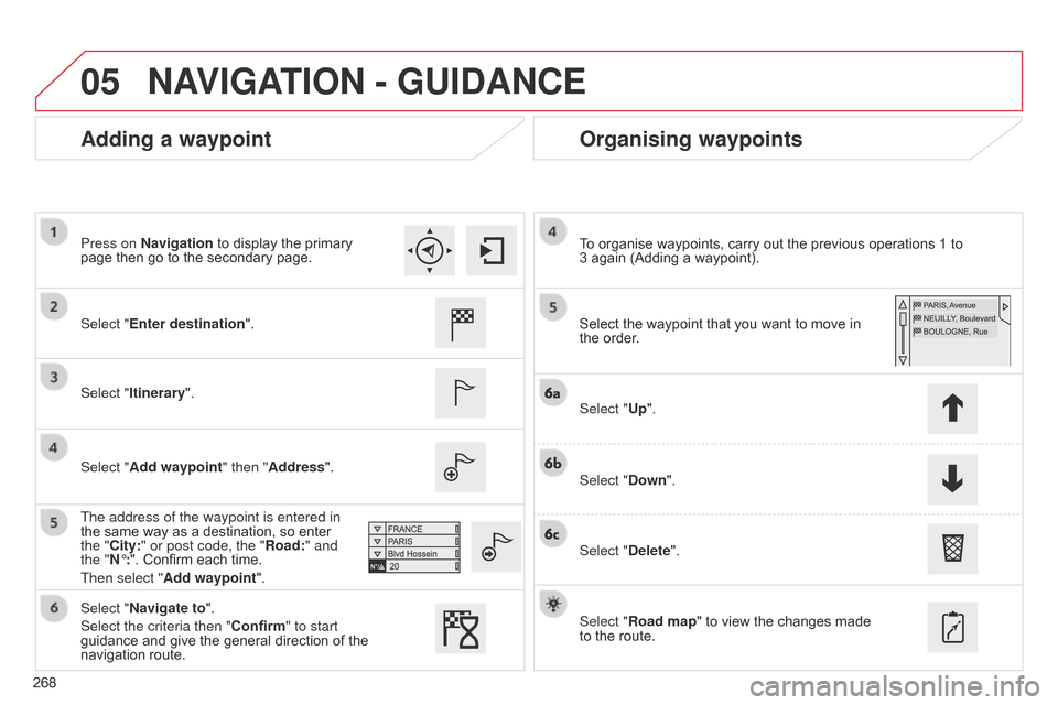
Adding a waypointOrganising waypoints
Select "Enter destination".
Select "Itinerary".
Select "Add waypoint" then "Address".
The address of the waypoint is entered in
the
ô same ô way ô as ô a ô destination, ô so ô enter ô
the "
City:" or post code, the "Road:" and
the "Nô¯:".
ô Confirm ô each ô time.
Then select "Add waypoint ". Select
ô the ô waypoint ô that ô you ô want ô to ô move ô in ô the
ô order.
To
ô organise ô waypoints, ô carry ô out ô the ô previous ô operations ô 1 ô to ô
3ô again
ô (Adding ô a ô waypoint).
Select "Up".
Select "Down".
Select "Delete".
Select "Road map"
ô to ô view ô the ô changes ô made ô
to
ô the ô route.
Select "Navigate to".
Select the criteria then "Confirm" to start
guidance
ô and ô give ô the ô general ô direction ô of ô the ô
navigation
ô route.
Press on Navigation
ô to ô display ô the ô primary ô
page
ô then ô go ô to ô the ô secondary ô page.
NAVIGATION - GUIDANCE