GMC YUKON XL DENALI 2005 User Guide
Manufacturer: GMC, Model Year: 2005, Model line: YUKON XL DENALI, Model: GMC YUKON XL DENALI 2005Pages: 62, PDF Size: 1.17 MB
Page 11 of 62
Features and Controls......................................2-2
Using the Navigation System...........................2-2
Maps............................................................2-5
Symbols........................................................2-6
Navigation Menu............................................2-7
Destination..................................................2-16
Colors on the Screen....................................2-30Con�gure Menu............................................2-31
Global Positioning System (GPS)....................2-34
Vehicle Positioning........................................2-35
Problems with Route Guidance.......................2-36
If the System Needs Service..........................2-36
Ordering Map DVDs......................................2-36
Database Coverage Explanations....................2-36
Section 2 Features and Controls
2-1
Page 12 of 62
Features and Controls
Using the Navigation System
This section includes the basic information you will need
to know to operate the navigation system.
The main navigation menu displays a number of
options which offer information on a variety of topics.
SeeNavigation Menu on page 2-7for more information.
Use the keys located to the left of the navigation
screen along with the available touch-sensitive screen
buttons on the navigation screen to operate the system.
Once the vehicle is moving, various functions will be
disabled to reduce driver distractions.
Hard Keys
The following hard keys are located to the left of the
navigation screen:
P(Power/Volume Knob):Press the power/volume
knob to turn the audio and navigation systems on
and off. Turn the knob to increase or decrease the
volume to the audio system.
NAV RPT (Navigation Repeat):Press the NAV RPT
key to repeat the current voice guidance navigation
prompt.
NAV (Navigation):If you are in a menu and are not on
the map screen, press the NAV key to view the map
showing current vehicle position.
If a route has not been planned, pressing this key will
display the map screen and the following information:
North or Heading Up symbol
Time
Map scale
2-2
Page 13 of 62
If a route has been planned, pressing this key will
display the map screen and the following information:
Number of miles/kilometers between current
vehicle position and the destination. See “Route
Overview Menu” underDestination on page 2-16
for more information.
Estimated travel time to the destination. See “Route
Overview Menu” underDestination on page 2-16for
more information.
Highlighted route or turn-by-turn instructions.
See “Map Appearance” underNavigation Menu on
page 2-7for more information.
You will �nd more information on each feature found on
a map screen later in this manual.
BAND:Press the BAND key to access the BAND
screen and switch between AM, FM1, FM2, XM1, or
XM2, if equipped. See “Finding a Station” under
Navigation Audio System on page 3-2.
xSEEKw:Press the SEEK up or down arrows to
go to the next or previous radio station and stay
there. See “Finding a Station” underNavigation Audio
System on page 3-2.
B(CD):Press the CD key to play a CD. The CD
screen will be displayed. See “Playing a CD” under
Navigation Audio System on page 3-2.
e(Audio):Press the audio key to access the Audio
menu. SeeNavigation Audio System on page 3-2.
CONFIG (Configure):Press the CONFIG key to access
the Con�gure menu. SeeConfigure Menu on page 2-31
for more information.
Tuning Knob:Turn the tuning knob to go to the next
or previous radio station and stay there. See “Finding a
Station” underNavigation Audio System on page 3-2.
X(Eject):Press the eject key located above the
DVD/CD slot to eject a map DVD or CD.
2-3
Page 14 of 62
Touch-Sensitive Screen Buttons
Touch-sensitive buttons are located on the navigation
screen. When you have successfully selected a
button on the screen, a beep will sound. This feature
can also be turned off. SeeConfigure Menu on
page 2-31for more information. Screen buttons will be
highlighted when available and dim when they are
unavailable. There are also some toggle touch-sensitive
screen buttons that will be light blue when active and
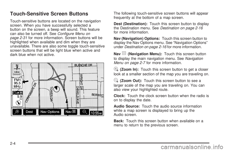
dark blue when not active.The following touch-sensitive screen buttons will appear
frequently at the bottom of a map screen.
Dest (Destination):Touch this screen button to display
the Destination menu. SeeDestination on page 2-16
for more information.
Nav (Navigation) Options:Touch this screen button to
display the Nav Options menu. See “Navigation Options”
underDestination on page 2-16for more information.
Nav
y(Navigation Menu):Touch this screen button
to display the main navigation menu. SeeNavigation
Menu on page 2-7for more information.
V(Zoom In):Touch this screen button to get a closer
look at a smaller section of the map you are traveling on.
U(Zoom Out):Touch this screen button to see a
larger scale of the map you are traveling on. You can
also view your highlighted route.
Clock:Touch the clock screen button when the radio is
on to display the date.
Audio Source:Touch the audio source information
while a map screen is displayed to bring up the
Audio screen.
Back:Touch this screen button when available on a
menu to return to the previous screen.
2-4
Page 15 of 62
Maps
This section includes basic information that you need to
know about the map database.
The maps are stored on a DVD-ROM. The United
States, Hawaii, and Canada are contained on one disc.
The map database includes interstate freeways,
state highways, country roads, and major and
general streets.
Refer to the “Navigation System Map Disc” manual to
view the explanation of map coverage. The map
disc manual will be in your map DVD case when the
vehicle is delivered from the factory.
When your vehicle is delivered from the factory, the
dealer may have installed the map DVD. If the DVD
was not installed in your vehicle when �rst purchased,
do the following:
1. Turn the ignition on.
2. Load the map DVD into the slot by inserting it
partway. The system will pull it in.Once the map DVD is inserted correctly, you will have
the following two choices:ENG (English)
FR (French)
You can select the language at this time. See
“Language” underConfigure Menu on page 2-31for
more information. Once a language has been selected,
touch the NEXT screen button to plan a route. The
map will appear showing your current vehicle position.
Map Adjustments and Scales
The system allows you to adjust the scale of view on
the map. The map will scroll automatically based on the
direction you are traveling.
To view a larger or smaller scale of the map, touch
zoom in or zoom out. See “Hard Keys” underUsing the
Navigation System on page 2-2for more information.
The scale of a map can range from 1/32 of a mile
(0.05 km) to 128 miles (206 km).
2-5
Page 16 of 62
Symbols
The following symbols are the most common that
appear on a map screen.
Your vehicle is shown as
this symbol. It indicates the
current position of your
vehicle on the map.
This red bulls-eye symbol
will appear on the map to
show your destination
after a route has been
planned.
SeeDestination on page 2-16for information on
planning a route.
When one of �ve possible destinations has been set,
you will see a circle with numbers 1 through 5,
depending on which number destination it is.This symbol indicates
that the map is shown
with North up, known as
North Up mode.
While in North Up mode, North will always be at the top
of the map screen regardless of which direction the
vehicle is traveling. See “Map Appearance” under
Navigation Menu on page 2-7for more information.
This symbol indicates
that the map is shown
with the vehicle travel
direction up, known
as Heading Up mode.
The shaded triangle indicates North. While in Heading
Up mode, the direction your vehicle is traveling will
always be at the top of the map screen. See “Map
Appearance” underNavigation Menu on page 2-7for
more information.
2-6
Page 17 of 62
Navigation Menu
Navy(Navigation Menu):Touch the navigation
menu symbol screen button at the bottom of the map
screen to access the main navigation menu.
The main navigation menu allows you to choose from a
list of options and to use the available touch screen
buttons to make system adjustments and plan routes.You will be able to choose from the following items on
the main navigation menu:
Suspend Guidance
Selecting the Suspend Guidance screen button from the
Nav Menu allows you to suspend guidance to all current
and programmed destinations, but the current route will
be retained in memory. You will no longer receive voice
prompts for navigation. The map can still be viewed by
pressing the NAV hard key. If you suspend guidance,
you can touch the Resume Guidance screen button to
resume the current route.
2-7
Page 18 of 62
Route Overview
Selecting the Route Overview screen button will show
the map with the route highlighted. The total distance
and estimated travel time are also displayed.
Map Appearance
Selecting the Map Appearance screen button allows
you to adjust the appearance of a map based on your
preferences.
This menu is divided into three sections: Map Orient
(orientation), Guidance Mode, and Map Mode.
Touch an option’s screen button to select it.The following are brief explanations of the options
available in each section:
North Up:This feature orients the map with North at
the top of the map screen, regardless of which direction
you are driving.
Heading Up:This feature orients the map with the
direction you are driving at the top of the map screen,
regardless of which direction is North.
3D view:This feature gives maps a 3-dimensional
view, and will remain in the Heading Up position.
Arrow:This feature continually displays directional turn
guidance for your next maneuver.
Turn list:This feature lists information on your next
three maneuvers, including the distance to the turn, and
street names.
Map:This feature will display your current position,
with the calculated route highlighted.
Single:This feature allows one map to be displayed.
Split Screen:This feature allows two maps to be
displayed, which can be independently adjusted in both
scale and map orientation.
For more information on the symbols that can appear
on a map screen, seeSymbols on page 2-6.
2-8
Page 19 of 62
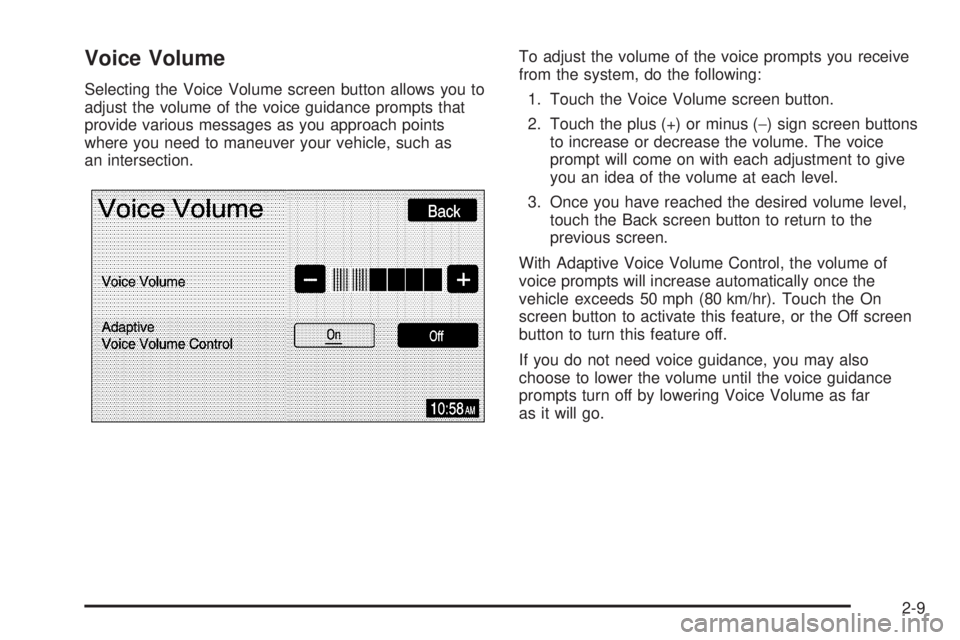
Voice Volume
Selecting the Voice Volume screen button allows you to
adjust the volume of the voice guidance prompts that
provide various messages as you approach points
where you need to maneuver your vehicle, such as
an intersection.To adjust the volume of the voice prompts you receive
from the system, do the following:
1. Touch the Voice Volume screen button.
2. Touch the plus (+) or minus (−) sign screen buttons
to increase or decrease the volume. The voice
prompt will come on with each adjustment to give
you an idea of the volume at each level.
3. Once you have reached the desired volume level,
touch the Back screen button to return to the
previous screen.
With Adaptive Voice Volume Control, the volume of
voice prompts will increase automatically once the
vehicle exceeds 50 mph (80 km/hr). Touch the On
screen button to activate this feature, or the Off screen
button to turn this feature off.
If you do not need voice guidance, you may also
choose to lower the volume until the voice guidance
prompts turn off by lowering Voice Volume as far
as it will go.
2-9
Page 20 of 62
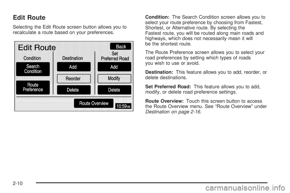
Edit Route
Selecting the Edit Route screen button allows you to
recalculate a route based on your preferences.Condition:The Search Condition screen allows you to
select your route preference by choosing from Fastest,
Shortest, or Alternative route. By selecting the
Fastest route, you will be routed along main roads and
highways, which does not necessarily mean it will
be the shortest route.
The Route Preference screen allows you to select your
road preferences by setting which types of roads
you wish to use or avoid.
Destination:This feature allows you to add, reorder, or
delete destinations.
Set Preferred Road:This feature allows you to add,
modify, or delete road preference settings.
Route Overview:Touch this screen button to access
the Route Overview menu. See “Route Overview” under
Destination on page 2-16.
2-10