light HONDA ACCORD 2012 8.G Navigation Manual
[x] Cancel search | Manufacturer: HONDA, Model Year: 2012, Model line: ACCORD, Model: HONDA ACCORD 2012 8.GPages: 156, PDF Size: 7.2 MB
Page 56 of 156
56
Navigation System
Accord 2D4D_KA 31TA5840
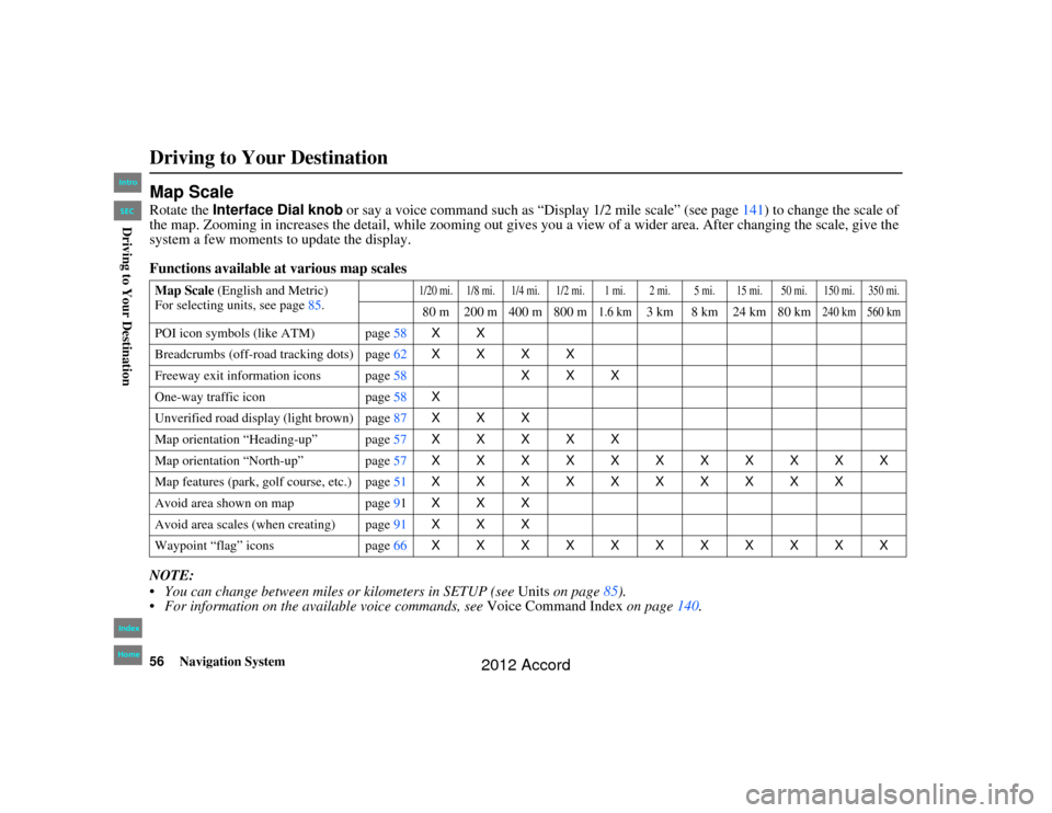
Map ScaleRotate the Interface Dial knob or say a voice command such as “Display 1/2 mile scale” (see page 141) to change the scale of
the map. Zooming in increases the detail, while zooming out gives you a view of a wider area. After changing the scale, give th e
system a few moments to update the display.
Functions available at various map scales
NOTE:
You can change between mile s or kilometers in SETUP (see Units on page 85).
For information on the available voice commands, see Voice Command Index on page140.Map Scale (English and Metric)
For selecting units, see page 85.
1/20 mi. 1/8 mi. 1/4 mi. 1/2 mi. 1 mi. 2 mi. 5 mi. 15 mi. 50 mi. 150 mi. 350 mi.80 m 200 m 400 m 800 m
1.6 km
3 km 8 km 24 km 80 km
240 km 560 km
POI icon symbols (like ATM) page 58XX
Breadcrumbs (off-road tracking dots) page62XXXX
Freeway exit information icons page 58XXX
One-way traffic icon page58 X
Unverified road display (light brown) page 87XXX
Map orientation “Heading-up” page 57XXXXX
Map orientation “North-up” page 57XXXXXXXXXXX
Map features (park, golf course, etc.) page 51XXXXXXXXXX
Avoid area shown on map page91 XXX
Avoid area scales (when creating) page 91XXX
Waypoint “flag” icons page66 XXXXXXXXXXXDriving to Your Destination00_Accord 2D4D_KA.book 56 ページ 2011年7月21日 木曜日 午後1時59分
IntroIndex
HomeSECDriving to Your Destination
2012 Accord
Page 63 of 156
Navigation System63
Accord 2D4D_KA 31TA5840
Driving to Your Destination
Viewing/Saving the Current
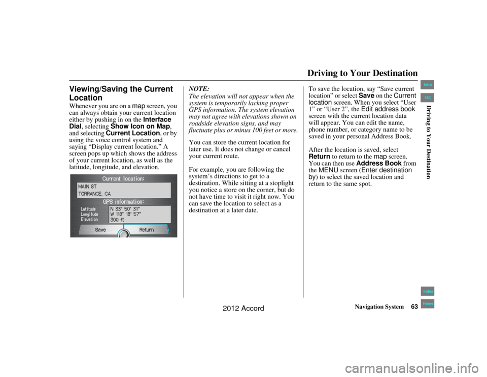
LocationWhenever you are on a map screen, you
can always obtain your current location
either by pushing in on the Interface
Dial , selecting Show Icon on Map ,
and selecting Current Location, or by
using the voice control system and
saying “Display current location.” A
screen pops up which shows the address
of your current location, as well as the
latitude, longitude, and elevation. NOTE:
The elevation will not appear when the
system is temporarily lacking proper
GPS information. The system elevation
may not agree with elevations shown on
roadside elevation signs, and may
fluctuate plus or minus 100 feet or more.
You can store the current location for
later use. It does not change or cancel
your current route.
For example, you are following the
system’s directions to get to a
destination. While sitting at a stoplight
you notice a store on the corner, but do
not have time to visit it right now. You
can save the location to select as a
destination at a later date.To save the location, say “Save current
location” or select Save
on the Current
location screen. When you select “User
1” or “User 2”, the Edit address book
screen with the current location data
will appear. You ca n edit the name,
phone number, or category name to be
saved in your personal Address Book.
After the location is saved, select
Return to return to the map screen.
You can then use Address Book from
the MENU screen ( Enter destination
by ) to select the saved location and
return to the same spot.00_Accord 2D4D_KA.book 63 ページ 2011年7月21日 木曜日 午後1時59分
IntroIndex
HomeSECDriving to Your Destination
2012 Accord
Page 71 of 156
Navigation System71
Accord 2D4D_KA 31TA5840
Information Features
Elapsed Time
Shows the elapsed time that the ignition
has been on.
Average Speed
Shows you the average speed in miles
per hour (mph) since the trip meter was
last reset.
Range
Shows the estimated distance you can
travel on the fuel remaining in the tank.
This distance is estimated from the
average fuel economy over the last
several miles, so it will vary with
changes in speed, traffic, etc.
NOTE:
Information from the Trip Computer
will be displayed only when the
ignition is on.
The “Instant Fuel” and “Average Fuel” may vary from actual fuel
consumed. These values are estimates
only.
The “Range” is only an estimate. Always monitor your vehicle’s fuel
gauge to determine the appropriate
time to refuel.
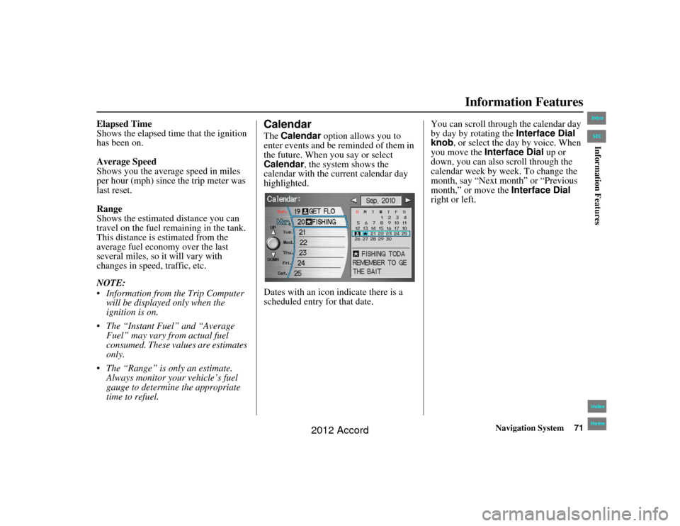
CalendarThe Calendar option allows you to
enter events and be reminded of them in
the future. When you say or select
Calendar , the system shows the
calendar with the current calendar day
highlighted.
Dates with an icon indicate there is a
scheduled entry for that date. You can scroll through the calendar day
by day by rotating the
Interface Dial
knob, or select the day by voice. When
you move the Interface Dial up or
down, you can also scroll through the
calendar week by week. To change the
month, say “Next month” or “Previous
month,” or move the Interface Dial
right or left.
00_Accord 2D4D_KA.book 71 ページ 2011年7月21日 木曜日 午後1時59分
IntroIndex
HomeSECInformation Features
2012 Accord
Page 87 of 156
Navigation System87
Accord 2D4D_KA 31TA5840
System Setup
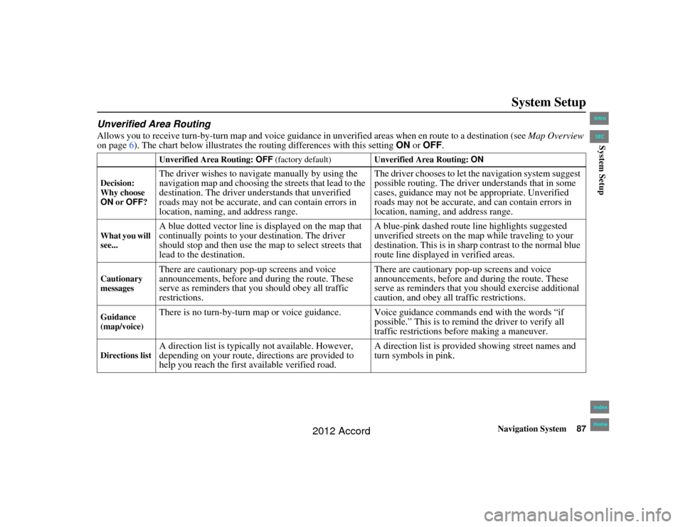
Unverified Area RoutingAllows you to receive turn-b y-turn map and voice guidance in unverified areas when en route to a destination (see Map Overview
on page 6). The chart below illustrates the routing differences with this setting ON or OFF .
Unverified Area Routing: OFF (factory default) Unverified Area Routing: ON
Decision:
Why choose
ON or OFF ?The driver wishes to naviga te manually by using the
navigation map and choosing the streets that lead to the
destination. The driver understands that unverified
roads may not be accurate, and can contain errors in
location, naming, and address range. The driver chooses to let the navigation system suggest
possible routing. The driver understands that in some
cases, guidance may not be appropriate. Unverified
roads may not be accurate, and can contain errors in
location, naming, and address range.
What you will
see...
A blue dotted vector line is displayed on the map that
continually points to your destination. The driver
should stop and then use the
map to select streets that
lead to the destination. A blue-pink dashed route line highlights suggested
unverified streets on the map while traveling to your
destination. This is in sharp
contrast to the normal blue
route line displayed in verified areas.
Cautionary
messages
There are cautionary pop-up screens and voice
announcements, before and during the route. These
serve as reminders that you should obey all traffic
restrictions. There are cautionary pop-up screens and voice
announcements, before and during the route. These
serve as reminders that you should exercise additional
caution, and obey all traffic restrictions.
Guidance
(map/voice)
There is no turn-by-turn map or voice guidance. Voice guidance commands end with the words “if
possible.” This is to remind the driver to verify all
traffic restrictions before making a maneuver.
Directions list
A direction list is typically not available. However,
depending on your route, directions are provided to
help you reach the first available verified road. A direction list is provided showing street names and
turn symbols in pink.
00_Accord 2D4D_KA.book 87 ページ 2011年7月21日 木曜日 午後1時59分
IntroIndex
HomeSECSystem Setup
2012 Accord
Page 88 of 156
88
Navigation System
Accord 2D4D_KA 31TA5840
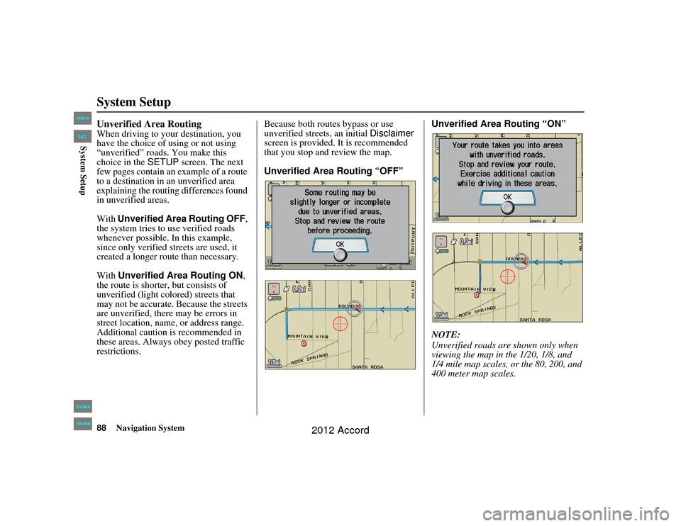
System SetupUnverified Area RoutingWhen driving to your destination, you
have the choice of using or not using
“unverified” roads. You make this
choice in the SETUP screen. The next
few pages contain an example of a route
to a destination in an unverified area
explaining the routing differences found
in unverified areas.
With Unverified Area Routing OFF,
the system tries to use verified roads
whenever possible. In this example,
since only verified streets are used, it
created a longer route than necessary.
With Unverified Area Routing ON ,
the route is shorter, but consists of
unverified (light colored) streets that
may not be accurate. Because the streets
are unverified, there may be errors in
street location, name, or address range.
Additional caution is recommended in
these areas. Always obey posted traffic
restrictions. Because both routes bypass or use
unverified street
s, an initial Disclaimer
screen is provided. It is recommended
that you stop and review the map.
Unverified Area Routing “OFF” Unverified Area Routing “ON”
NOTE:
Unverified roads are
shown only when
viewing the map in the 1/20, 1/8, and
1/4 mile map scales, or the 80, 200, and
400 meter map scales.00_Accord 2D4D_KA.book 88 ページ 2011年7月21日 木曜日 午後1時59分
IntroIndex
HomeSECSystem Setup
2012 Accord
Page 91 of 156
Navigation System91
Accord 2D4D_KA 31TA5840
System Setup
Edit Avoid AreaThis function allows you to select areas
you wish to avoid when calculating a
route to your destination. You can select
up to five areas to avoid. You may wish
to set up an “avoid area” to route around
long-term road construction, closures,
or any area you wish to avoid. If you
enter a route that takes you through or
into an “avoid area,” a pop-up box will
warn you that your route takes you into
one of these areas. However, you can
still choose destinations in an avoided
area.
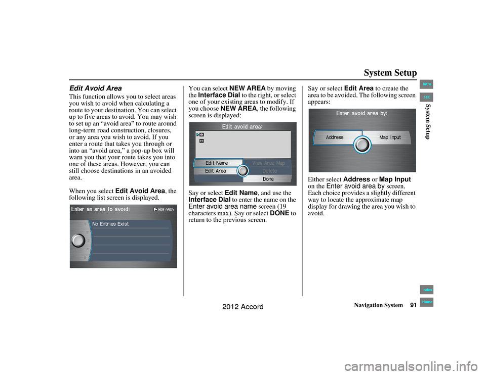
When you select Edit Avoid Area , the
following list screen is displayed. You can select NEW AREA
by moving
the Interface Dial to the right, or select
one of your existing areas to modify. If
you choose NEW AREA , the following
screen is displayed:
Say or select Edit Name, and use the
Interface Dial to enter the name on the
Enter avoid area name screen (19
characters max). Say or select DONE to
return to the previous screen. Say or select
Edit Area to create the
area to be avoided. The following screen
appears:
Either select Address or Map Input
on the Enter avoid area by screen.
Each choice provides a slightly different
way to locate th e approximate map
display for drawing the area you wish to
avoid.00_Accord 2D4D_KA.book 91 ページ 2011年7月21日 木曜日 午後1時59分
IntroIndex
HomeSECSystem Setup
2012 Accord
Page 93 of 156
Navigation System93
Accord 2D4D_KA 31TA5840
System Setup
NOTE:
You can select areas to avoid,
however you cannot select roads or
areas that you want the system to use
for routing.
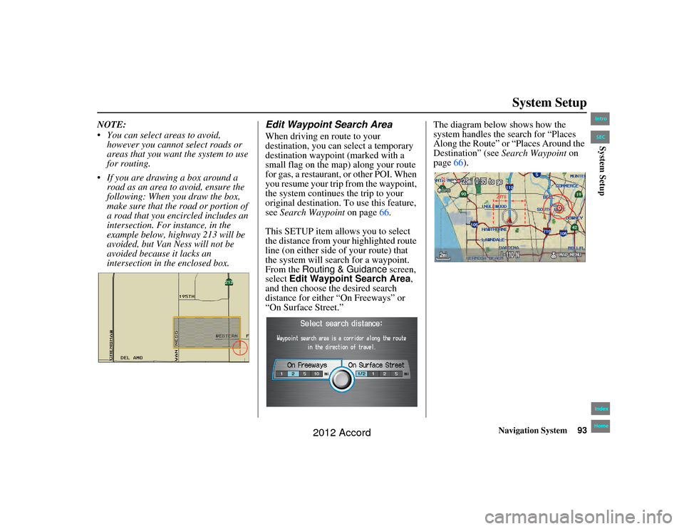
If you are drawing a box around a road as an area to avoid, ensure the
following: When you draw the box,
make sure that the road or portion of
a road that you encircled includes an
intersection. For instance, in the
example below, highway 213 will be
avoided, but Van Ness will not be
avoided because it lacks an
intersection in th e enclosed box.
Edit Waypoint Search AreaWhen driving en route to your
destination, you can select a temporary
destination waypoint (marked with a
small flag on the map) along your route
for gas, a restaurant, or other POI. When
you resume your trip from the waypoint,
the system continues the trip to your
original destination. To use this feature,
see Search Waypoint on page66.
This SETUP item allows you to select
the distance from your highlighted route
line (on either side of your route) that
the system will search for a waypoint.
From the Routing & Guidance screen,
select Edit Waypoint Search Area ,
and then choose the desired search
distance for either “On Freeways” or
“On Surface Street.” The diagram below shows how the
system handles the search for “Places
Along the Route” or “Places Around the
Destination” (see
Search Waypoint on
page 66).
00_Accord 2D4D_KA.book 93 ページ 2011年7月21日 木曜日 午後1時59分
IntroIndex
HomeSECSystem Setup
2012 Accord
Page 94 of 156
94
Navigation System
Accord 2D4D_KA 31TA5840
System SetupFor “Places Along the Route,” the
system looks in front of you within a
corridor width specified by your values
for “On Freeways” or “On Surface
Street.” The system checks the
upcoming area, based on your input.
For “Places Around the Destination,”
the system searches outwards in a spiral
from the destination. In this case,
specific search values are not needed;
the matches are displayed in order of
distance from destination.
NOTE:
These settings do not affect the search
range used for the voice commands like
“Find nearest gas station” that are also
available when viewing the map screen.
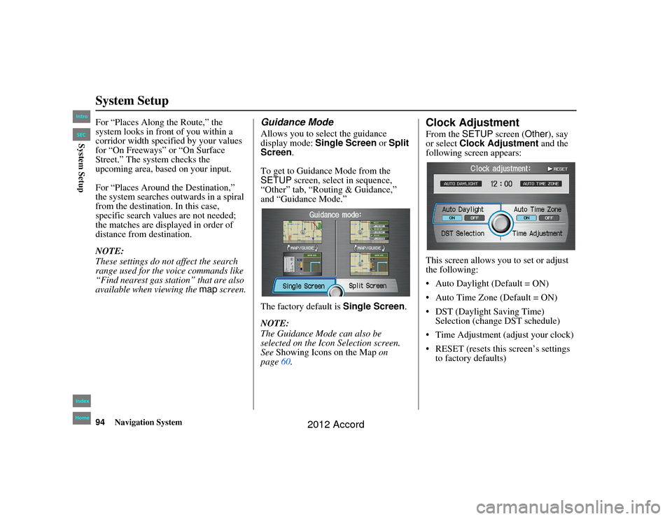
Guidance ModeAllows you to select the guidance
display mode: Single Screen or Split
Screen .
To get to Guidance Mode from the
SETUP screen, select in sequence,
“Other” tab, “Routing & Guidance,”
and “Guidance Mode.”
The factory default is Single Screen.
NOTE:
The Guidance Mode can also be
selected on the Icon Selection screen.
See Showing Icons on the Map on
page 60.
Clock AdjustmentFrom the SETUP screen ( Other), say
or select Clock Adjustment and the
following screen appears:
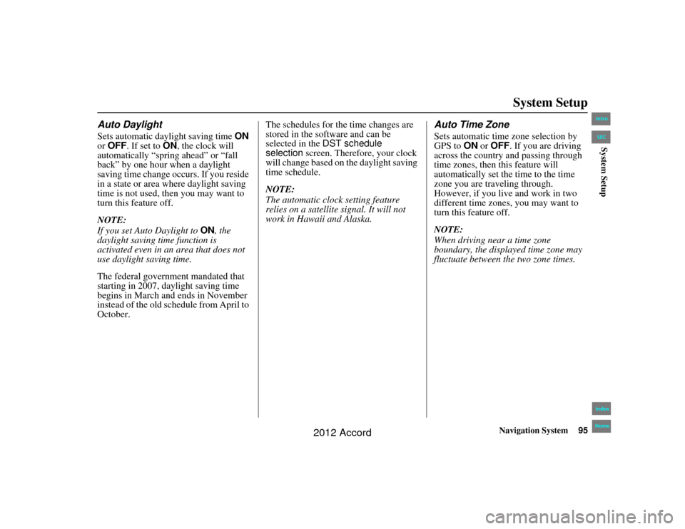
This screen allows yo u to set or adjust
the following:
Auto Daylight (Default = ON)
Auto Time Zone (Default = ON)
DST (Daylight Saving Time) Selection (change DST schedule)
Time Adjustment (adjust your clock)
RESET (resets this screen’s settings to factory defaults)
00_Accord 2D4D_KA.book 94 ページ 2011年7月21日 木曜日 午後1時59分
IntroIndex
HomeSECSystem Setup
2012 Accord
Page 95 of 156
Navigation System95
Accord 2D4D_KA 31TA5840
System Setup
Auto DaylightSets automatic daylight saving time ON
or OFF . If set to ON, the clock will
automatically “spring ahead” or “fall
back” by one hour when a daylight
saving time change occurs. If you reside
in a state or area where daylight saving
time is not used, then you may want to
turn this feature off.
NOTE:
If you set Auto Daylight to ON, the
daylight saving time function is
activated even in an area that does not
use daylight saving time.
The federal government mandated that
starting in 2007, daylight saving time
begins in March and ends in November
instead of the old schedule from April to
October. The schedules for the time changes are
stored in the software and can be
selected in the
DST schedule
selection screen. Therefore, your clock
will change based on the daylight saving
time schedule.
NOTE:
The automatic clock setting feature
relies on a satellite signal. It will not
work in Hawaii and Alaska.
Auto Time ZoneSets automatic time zone selection by
GPS to ON or OFF . If you are driving
across the country and passing through
time zones, then this feature will
automatically set the time to the time
zone you are traveling through.
However, if you live and work in two
different time zones, you may want to
turn this feature off.
NOTE:
When driving near a time zone
boundary, the displayed time zone may
fluctuate between the two zone times.
00_Accord 2D4D_KA.book 95 ページ 2011年7月21日 木曜日 午後1時59分
IntroIndex
HomeSECSystem Setup
2012 Accord
Page 96 of 156
96
Navigation System
Accord 2D4D_KA 31TA5840
System SetupDaylight Saving Time (DST)
Selection (Change DST
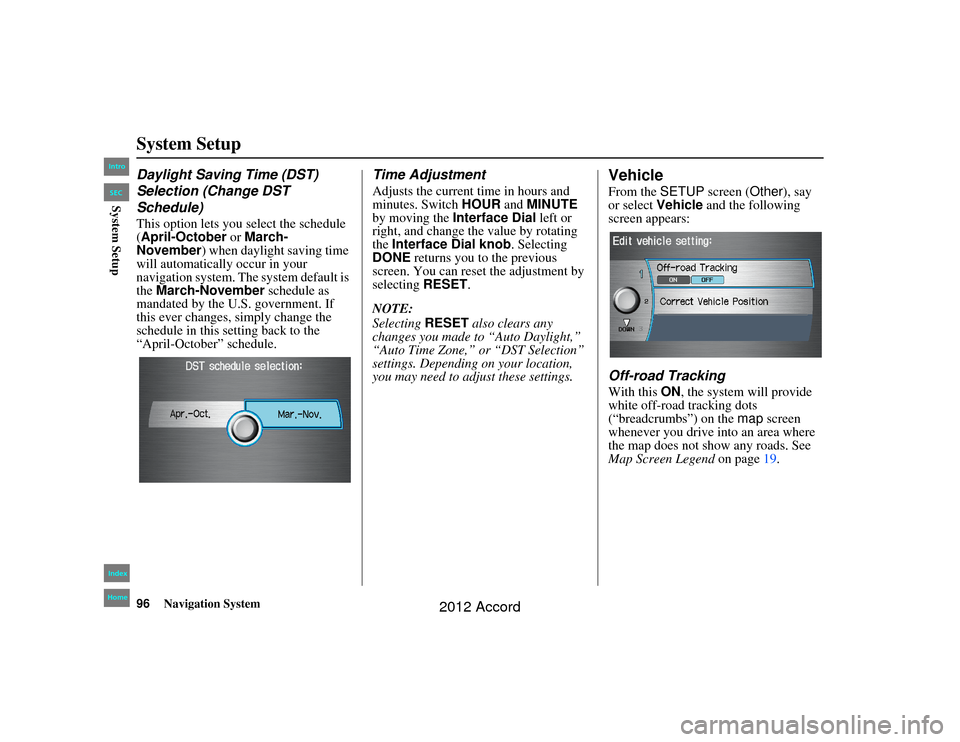
Schedule)This option lets you select the schedule
(April-October or March-
November ) when daylight saving time
will automatically occur in your
navigation system. The system default is
the March-November schedule as
mandated by the U.S. government. If
this ever changes, simply change the
schedule in this setting back to the
“April-October” schedule.
Time AdjustmentAdjusts the current time in hours and
minutes. Switch HOUR and MINUTE
by moving the Interface Dial left or
right, and change the value by rotating
the Interface Dial knob . Selecting
DONE returns you to the previous
screen. You can reset the adjustment by
selecting RESET.
NOTE:
Selecting RESET also clears any
changes you made to “Auto Daylight,”
“Auto Time Zone,” or “DST Selection”
settings. Depending on your location,
you may need to ad just these settings.
VehicleFrom the SETUP screen ( Other), say
or select Vehicle and the following
screen appears:Off-road TrackingWith this ON, the system will provide
white off-road tracking dots
(“breadcrumbs”) on the map screen
whenever you drive into an area where
the map does not show any roads. See
Map Screen Legend on page19.
00_Accord 2D4D_KA.book 96 ページ 2011年7月21日 木曜日 午後1時59分
IntroIndex
HomeSECSystem Setup
2012 Accord