light HONDA FIT 2010 2.G Navigation Manual
[x] Cancel search | Manufacturer: HONDA, Model Year: 2010, Model line: FIT, Model: HONDA FIT 2010 2.GPages: 151, PDF Size: 3.59 MB
Page 122 of 151
122Navigation System
Setup Screen Differences
The Setup screen differences are minor
and are listed belo w. See the Setup
section (page 73) for additional
information.
Routing and Guidan ce (Unverified
Area Routing On/Off)
This feature is unavailable. All roads
displayed on the map are verified.
Clock Adjust Screen
There is no daylight saving time for
Hawaii. Auto Daylight Saving
Time, Auto Time Zone by GPS , and
DST Selection will not be shown on
the Clock adjustment screen. To test
your adjustment, use the voice control
system, and say “What time is it?” (see
page 93).
Shipping a Vehicle To or From
Hawaii
Although the DVD in the vehicle
contains maps for both U.S. mainland
and Hawaii, the dealer must perform the
selection of “U.S. mainland” or
“Hawaii” for you. When the dealer
makes the switch from U.S. mainland to
Hawaii or vice versa, the system clears
all user data. Make sure to record any
personal information that you do not
want to lose.
Coverage Areas
2010 Fit
Page 124 of 151
124Navigation System
When I drive at night, the screen
is bright and will not switch
to the night display mode. Why? The system thinks it is in Day
display mode. Verify the following: The
display mode in Setup is set to Auto , the dash brightness is not set to
maximum (must adjust with headlights on), and Map Color in Setup is set
to Black for Night. See Display on page 74.
The daytime map screen is dark like the night display mode,
and it is hard to see. Why? Verify the following: The disp
lay mode in Setup is set to Auto, and Map
Color in Setup is set to White for Day. See Display on page 74.
During the day, I turned on the lights because it started to
rain, but the screen went dark. How can I make it still display
day mode? Adjust the dash brightness (+) button
(with headlights on) to full brightness.
Remember to set it back to a medium set ting, or at night, the screen will be
bright. See Display on page 74.
How can I input my destination using map coordinates? The navigation system was not designed for th is. However, you can view
the coordinates of an address by touching the vehicle position icon on the
map. See Map Screen Legend on page50.
How do I change or remove my PIN? Go to “Personal Information” in the Setup screen (second), and select PIN
Number . Select User 1 or User 2 and enter your existing PIN, and then
you have the choice to change or remove the PIN. See page 80.
I forgot the PIN for Home, or the PIN for personal addresses
(User 1 or User 2). How do I reset it? PINs are optional. See information regarding PINs on page
80. Your dealer
can reset the PIN for you.
Problem
Solution
Frequently Asked Questions
2010 Fit
Page 125 of 151
Navigation System125
Frequently Asked Questions
Guidance, Routing
Problem Solution
The navigation does not route me the same way I would go, or
the way some other mapping progr am displays. Why is this?The navigation system attempts to
generate the optimum route. See
Changing the Routing Method on page46.
Why is the street I’m on not shown on the map? It has been
here for more than a year. The mapping database is
constantly undergoing revision. See page103 for
ways to obtain the latest de tailed coverage information.
The vehicle position icon is not following the road, and the
“GPS icon” text in the upper left hand corner of the screen is
white or missing. • The GPS antenna (located under th
e center of the dashboard) may be
blocked by personal items. For best reception, remove items from the
dashboard, such as radar detector s, cell phones, or loose articles.
• Metallic tinting or other aftermarke t devices can interfere with the GPS
reception. Please see your dealer. Also see System Limitations on page98.
I entered a destination, but th e blue highlighted route and
voice guidance stopped, or turned into a blue/pink dashed line
before I got to my dest ination. Why is this? Your route has entered
an unverified area. See Unverified Area Routing on
page 83.
The map rotates while I make turns. How can I stop this? Select the North-up map orientation by voice, or by touching the map
orientation icon on the map screen. See Map Orientation on page55.
Sometimes, I cannot select between the North-up and
Heading-up map orienta tions. Why is this? The Heading-up map orient
ation can only be shown in the lower scales
(1/20 - 1 mile scales). See Map Scale on page54.
While driving to my destinati on, the “time to go” display
sometimes increases, even though I am getting closer. The “Time to go” is based on actual
road speeds. However if your speed
slows down when you encounter slower traffic, the system updates the
“Time to go” based on your actual spee d to give you a better estimate of
arrival time.
The vehicle position icon on the map “lags” a short distance
behind, especially when I arrive at an intersection. Is there
anything wrong? No. When at an intersection, the syst
em is unaware of the width of the
intersecting road. Large differences in vehicle position can indicate a
temporary loss of the GPS signal. See GPS Reception Issues on page98.
2010 Fit
Page 130 of 151
130Navigation System
Frequently Asked Questions
I insert a CD-R with music files, but the CD button or “CD”
voice commands do not work. What is wrong? • After inserting a CD-R with WMA or
MP3 files, a slight delay may occur
before the CD button operates. Th e system needs to read the tag
information (album, artist, and track na mes) to allow searches - this is
normal.
• Ensure that the music files on the CD-R are WMA or MP3 format. Other
formats are not recognized.
• Some WMA and MP3 files are copy pr otected, and require that the
copyright authentication files accompany the MP3/WMA files on the CD.
Note:
Never use CD-R discs with stick-on labels. The labels can curl and
jam the CD mechanism, requiring re placement of the navigation unit
and subsequent loss of all personal information.
Problem Solution
2010 Fit
Page 131 of 151
Navigation System131
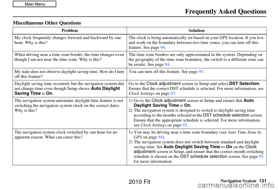
Miscellaneous Other Questions
Problem Solution
My clock frequently changes forward and backward by one
hour. Why is this? The clock is being automatically set ba
sed on your GPS location. If you live
and work on the boundary between two time zones, you can turn off this
feature. See page 94.
When driving near a time zone border, the time changes even
though I am not near the time zone. Why is this? The time zone borders are only appr
oximated in the system. Depending on
the geography of the time zone boundary, the switch to a different zone can
be erratic. See page 94.
My state does not observe dayli ght saving time. How do I turn
off this feature? You can turn off this feature. See page
93.
Daylight saving time occurred, but the navigation system did
not change time even though Setup shows Auto Daylight
Saving Time is On . Go to the
Clock adjustment screen in Setup and select DST Selection.
Ensure that the correct DST schedule is selected. For more information, see
Clock Settings on page93.
The navigation system automatic daylight time feature is not
switching the navigation system clock on the correct dates.
Why is this? 1) Go to the
Clock adjustment screen in Setup and ensure that Auto
Daylight Saving Time is On .
2) The navigation system is designed to switch to daylight saving time
according to the months selected in the DST schedule selection screen.
Ensure that the appropriate schedule is selected. For more information,
see Clock Settings on page93.
The navigation system clock switched by one hour for no
apparent reason. Wh at can cause this? 1) You may be driving near
a time zone boundary (see Auto Time Zone by
GPS on page 94).
2) The navigation system does not switch between standard and daylight
saving time. Set Auto Daylight Saving Time to On on the Clock
adjustment screen in Setup, and ensure that the correct month switching
schedule is chosen on the DST schedule selection screen. See page 93
for more information.
Frequently Asked Questions
2010 Fit
Page 136 of 151
136Navigation System
Glossary
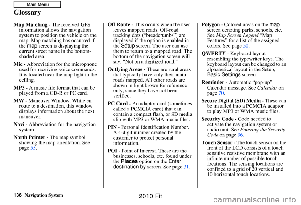
Map Matching - The received GPS information allows the navigation
system to position the vehicle on the
map. Map matching has occurred if
the map screen is displaying the
current street name in the bottom-
shaded area.
Mic - Abbreviation for the microphone
used for receiving voice commands.
It is located near the map light in the
ceiling.
MP3 - A music file format that can be played from a CD-R or PC card.
MW - Maneuver Window. While en
route to a destination, this window
displays informatio n about the next
maneuver.
Navi - Abbreviation for the navigation
system.
North Pointer - The map symbol showing the map orientation. See
page 55. Off Route - This occurs when the user
leaves mapped roads. Off-road
tracking dots (“breadcrumbs”) are
displayed if the option is enabled in
the Setup screen. The user can use
them to return to a mapped road. The
bottom of the navigation screen will
say, “Not on a digitized road.”
Outlying Areas - These are rural areas
that typically have only their main
roads mapped. All other roads are
shown in light brown for reference
only, since they have not been
verified.
PC Card - An adaptor card (sometimes
called a PCMCIA card) that can
contain a compact flash, or SD media
clip with MP3 or WMA music files.
PIN - Personal Identification Number.
A 4-digit number created by the
customer to protect personal
information.
POI - Point of Interest. These are the
businesses, schools, etc. found under
the Places option on the Enter
destination by screen. See page 31.Polygon - Colored areas on the
map
screen denoting parks, schools, etc.
See Map Screen Legend “Map
Features” for a list of the assigned
colors. See page 50.
QWERTY - Keyboard layout
resembling the typewriter keys. The
keyboard layout can be changed to an
alphabetical layout in the Setup,
Basic Settings screen.
Reminder - Automatic “pop-up” Calendar message. See Calendar on
page 70.
Secure Digital (SD) Media - These can
be installed into a PCMCIA adaptor
to play MP3 or WMA music files.
Security Code - Code needed to
activate the navigation system or
audio unit. See Entering the Security
Code on page 96.
Touch Sensor - The touch sensor on the
front of the LCD consists of a touch
sensitive resistive membrane with an
infinite number of possible touch
locations. The sensing locations are
confined to a grid of 20 vertical and
10 horizontal touch locations.
2010 Fit
Page 137 of 151
Navigation System137
Glossary
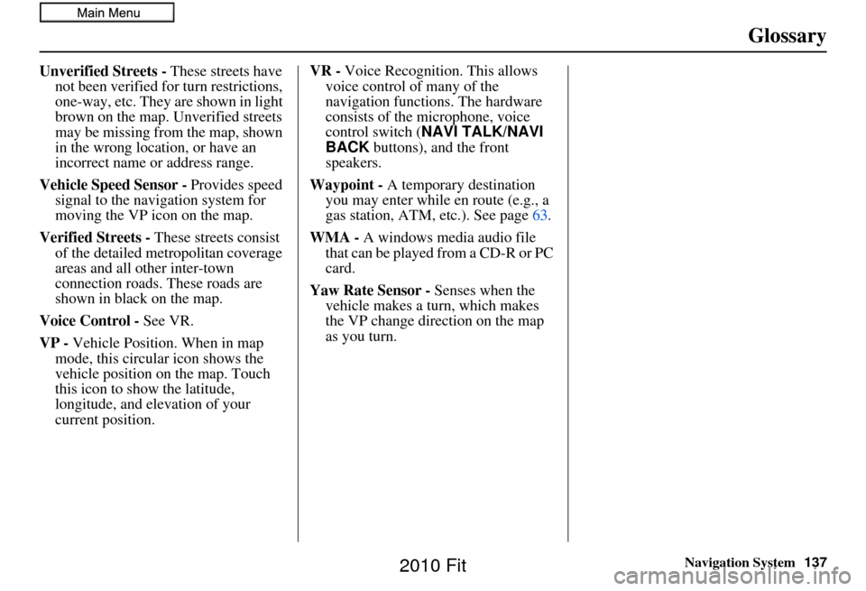
Unverified Streets - These streets have
not been verified for turn restrictions,
one-way, etc. They are shown in light
brown on the map. Unverified streets
may be missing from the map, shown
in the wrong location, or have an
incorrect name or address range.
Vehicle Speed Sensor - Provides speed
signal to the navigation system for
moving the VP icon on the map.
Verified Streets - These streets consist
of the detailed metropolitan coverage
areas and all other inter-town
connection roads. These roads are
shown in black on the map.
Voice Control - See VR.
VP - Vehicle Position. When in map
mode, this circular icon shows the
vehicle position on the map. Touch
this icon to show the latitude,
longitude, and elevation of your
current position. VR -
Voice Recognition. This allows
voice control of many of the
navigation functions. The hardware
consists of the microphone, voice
control switch ( NAVI TALK/NAVI
BACK buttons), and the front
speakers.
Waypoint - A temporary destination
you may enter while en route (e.g., a
gas station, ATM, etc.). See page 63.
WMA - A windows media audio file that can be played from a CD-R or PC
card.
Yaw Rate Sensor - Senses when the
vehicle makes a turn, which makes
the VP change direction on the map
as you turn.
2010 Fit
Page 146 of 151
146Navigation System
Index
A
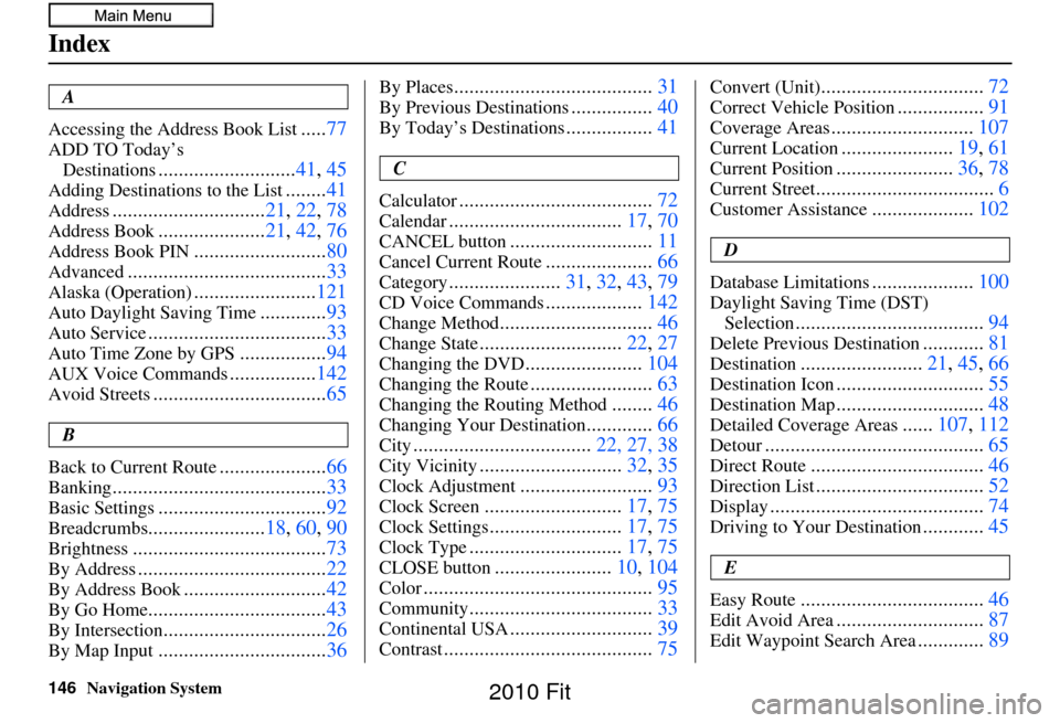
Accessing the Address Book List
..... 77
ADD TO Today’s
Destinations
........................... 41, 45
Adding Destinations to the List........41
Address.............................. 21, 22, 78
Address Book..................... 21, 42, 76
Address Book PIN.......................... 80
Advanced....................................... 33
Alaska (Operation)........................121
Auto Daylight Saving Time.............93
Auto Service................................... 33
Auto Time Zone by GPS.................94
AUX Voice Commands.................142
Avoid Streets.................................. 65
B
Back to Current Route
..................... 66
Banking.......................................... 33
Basic Settings.................................92
Breadcrumbs.......................18, 60, 90
Brightness...................................... 73
By Address.....................................22
By Address Book............................42
By Go Home................................... 43
By Intersection................................26
By Map Input................................. 36
By Places....................................... 31
By Previous Destinations................40
By Today’s Destinations................. 41
C
Calculator
...................................... 72
Calendar..................................17, 70
CANCEL button............................11
Cancel Current Route.....................66
Category...................... 31, 32, 43, 79
CD Voice Commands...................142
Change Method.............................. 46
Change State............................22, 27
Changing the DVD.......................104
Changing the Route........................ 63
Changing the Routing Method........46
Changing Your Destination............. 66
City................................... 22, 27, 38
City Vicinity............................32, 35
Clock Adjustment..........................93
Clock Screen........................... 17, 75
Clock Settings..........................17, 75
Clock Type.............................. 17, 75
CLOSE button.......................10, 104
Color............................................. 95
Community....................................33
Continental USA............................39
Contrast......................................... 75
Convert (Unit)................................72
Correct Vehicle Position.................91
Coverage Areas............................ 107
Current Location......................19, 61
Current Position....................... 36, 78
Current Street................................... 6
Customer Assistance....................102
D
Database Limitations
.................... 100
Daylight Saving Time (DST)
Selection
..................................... 94
Delete Previous Destination............81
Destination........................ 21, 45, 66
Destination Icon............................. 55
Destination Map.............................48
Detailed Coverage Areas......107, 112
Detour........................................... 65
Direct Route..................................46
Direction List.................................52
Display.......................................... 74
Driving to Your Destination............45
E
Easy Route
.................................... 46
Edit Avoid Area.............................87
Edit Waypoint Search Area.............89
2010 Fit