navigation update HONDA PILOT 2015 2.G Navigation Manual
[x] Cancel search | Manufacturer: HONDA, Model Year: 2015, Model line: PILOT, Model: HONDA PILOT 2015 2.GPages: 175, PDF Size: 5.87 MB
Page 2 of 175
2
Navigation System
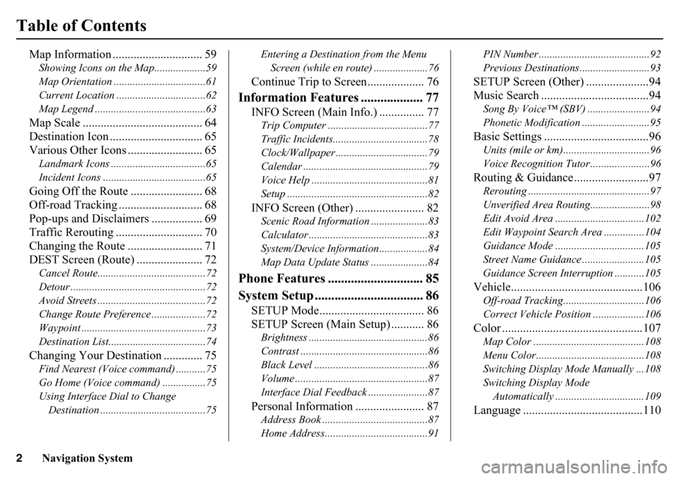
Table of Contents
Map Information .............................. 59Showing Icons on the Map...................59
Map Orientation ..................................61
Current Location .................................62
Map Legend .........................................63Map Scale ........................................ 64
Destination Icon ............................... 65
Various Other Icons ......................... 65Landmark Icons ...................................65
Incident Icons ......................................65Going Off the Route ........................ 68
Off-road Tracking ... ......................... 68
Pop-ups and Disclaimers ................. 69
Traffic Rerouting ............................. 70
Changing the Route ......................... 71
DEST Screen (Route) ...................... 72Cancel Route........................................72
Detour ..................................................72
Avoid Streets ........................................72
Change Route Preference ....................72
Waypoint ..............................................73
Destination List....................................74Changing Your Destination ............. 75Find Nearest (Voice command) ...........75
Go Home (Voice command) ................75
Using Interface Dial to Change Destination .......................................75 Entering a Destination from the Menu
Screen (while en route) ....................76
Continue Trip to Screen................... 76
Information Features ................... 77
INFO Screen (Main Info.) ............... 77Trip Computer .....................................77
Traffic Incidents......... ..........................78
Clock/Wallpaper ............ ......................79
Calendar ......... .......................... ...........79
Voice Help ...........................................81
Setup ....................................................82INFO Screen (Other) ....................... 82Scenic Road Information .....................83
Calculator ............................................83
System/Device Information..................84
Map Data Update Status .....................84
Phone Features ............................. 85
System Setup ................................. 86
SETUP Mode................................... 86
SETUP Screen (Main Setup) ........... 86Brightness ............................................86
Contrast ...............................................86
Black Level ..........................................86
Volume .................................................87
Interface Dial Feedback ......................87Personal Information ....................... 87Address Book .......................................87
Home Address......................................91 PIN Number .........................................92
Previous Destinations..........................93
SETUP Screen (Other) .....................94
Music Search ....................................94Song By Voice™ (SBV) .......................94
Phonetic Modification ...
......................95Basic Settings ...................................96Units (mile or km)................................96
Voice Recognition Tutor ......................96Routing & Guidance .........................97Rerouting .............................................97
Unverified Area Routing. .....................98
Edit Avoid Area .................................102
Edit Waypoint Search Area ...............104
Guidance Mode .................................105
Street Name Guidance . ......................105
Guidance Screen Interruption ...........105Vehicle............................................106Off-road Tracking........ ......................106
Correct Vehicle Position ...................106Color ...............................................107Map Color .........................................108
Menu Color........................................108
Switching Display Mode Manually ...108
Switching Display Mode Automatically .................................109Language ........................................110
Page 3 of 175
Navigation System3
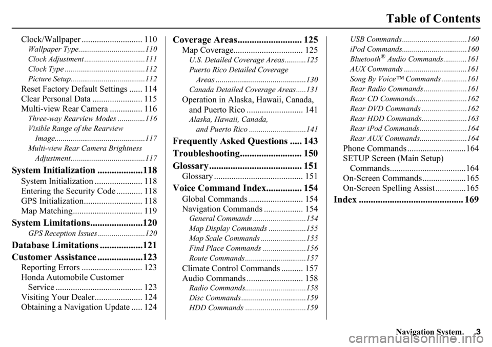
Table of Contents
Clock/Wallpaper ............................ 110Wallpaper Type..................................110
Clock Adjustment ...............................111
Clock Type .........................................112
Picture Setup......................................112Reset Factory Default Settings ...... 114
Clear Personal Data ....................... 115
Multi-view Rear Camera ............... 116Three-way Rearview Modes ..............116
Visible Range of the Rearview Image..............................................117
Multi-view Rear Camera Brightness Adjustment......................................117
System Initialization ...................118
System Initialization ...................... 118
Entering the Security Code ............ 118
GPS Initialization........................... 118
Map Matching................................ 119
System Limitations......................120
GPS Reception Issues ........................120
Database Limitations ..................121
Customer Assistance ...................123
Reporting Errors ............................ 123
Honda Automobile Customer Service ........................................ 123
Visiting Your Dealer...................... 124
Obtaining a Navigation Update ..... 124
Coverage Areas........................... 125
Map Coverage................................ 125U.S. Detailed Coverage Areas...........125
Puerto Rico Detailed Coverage
Areas ..............................................130
Canada Detailed Coverage Areas .....131Operation in Alaska, Hawaii, Canada, and Puerto Rico .......................... 141Alaska, Hawaii, Canada,
and Puerto Rico ......... ....................141
Frequently Asked Questions ..... 143
Troubleshooting.......................... 150
Glossary ....................................... 151
Glossary ......................................... 151
Voice Command Index............... 154
Global Commands ......................... 154
Navigation Commands .................. 154General Commands ....... ....................154
Map Display Commands ...................155
Map Scale Commands ...... .................155
Find Place Commands ......................156
Route Commands ........... ....................157Climate Control Commands .......... 157
Audio Commands .......................... 158Radio Commands........... ....................158
Disc Commands ............. ....................159
HDD Commands ...............................159 USB Commands .............
....................160
iPod Commands............. ....................160
Bluetooth
® Audio Commands............161
AUX Commands ................................161
Song By Voice™ Commands .............161
Rear Radio Commands ............. .........161
Rear CD Commands ...... ....................162
Rear DVD Commands .... ...................162
Rear HDD Commands.... ...................163
Rear iPod Commands .... ....................164
Rear AUX Commands.... ....................164
Phone Commands ...........................164
SETUP Screen (Main Setup)
Commands...................................164
On-Screen Commands ....................165
On-Screen Spelling Assist ..............165
Index ............................................ 169
Page 21 of 175
Navigation System21Getting Started
Map Screen DescriptionZoom In/OutRotate the Interface Dial knob to
change the map scale. Zooming in
increases the detail, while zooming out
gives you a wide area view. After
changing the scale, give the system a
few moments to update the display.Map ScrollingTo view other map areas, move the
Interface Dial left, right, up, or down.
The map will shift in that direction. To
return the map to yo ur current location,
press either the MAP/GUIDE,
CANCEL , or BACK button on the
steering wheel.
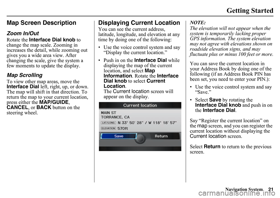
Displaying Current LocationYou can see the current address,
latitude, longitude, an d elevation at any
time by doing one of the following:
• Use the voice control system and say
“Display the current location.”
• Push in on the Interface Dial while
displaying the map of the current
location, and select Map
Information . Rotate the Interface
Dial knob to select Current
Location .
The Current location screen will
appear on the display. NOTE:
The elevation will no
t appear when the
system is temporarily lacking proper
GPS information. Th e system elevation
may not agree with elevations shown on
roadside elevation signs, and may
fluctuate plus or minus 100 feet or more.
You can save the current location in
your Address Book by doing one of the
following (if an Address Book PIN has
been set, you need to enter your PIN.):
• Use the voice control system and say
“Save.”
• Select Save by rotating the
Interface Dial knob and push in on
the Interface Dial .
Say “Register the current location” on
the map screen, and you can register the
current location with out displaying the
Current location screen.
Select Return to return to the previous
screen.
Page 22 of 175
22
Navigation System
Getting StartedTraffic Display Legend
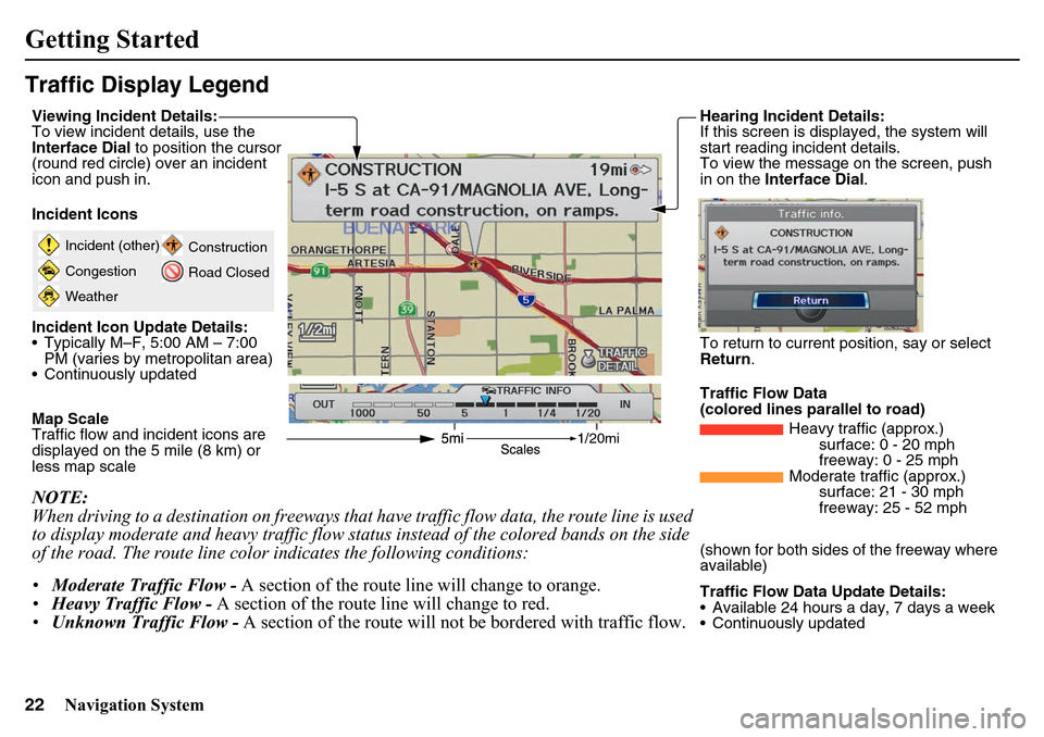
20mi
Incident (other)
Congestion
WeatherConstruction
Road Closed
Viewing Incident Details:
To view incident details, use the
Interface Dial
to position the cursor
(round red circle) over an incident
icon and push in.
Incident Icons
Incident Icon Update Details:
Typically M–F, 5:00 AM – 7:00 PM (varies by metropolitan area)
Continuously updated
Map Scale
Traffic flow and incident icons are
displayed on the 5 mile (8 km) or
less map scaleNOTE:
When driving to a destination on freeways that have traffic flow data, the route line is used
to display moderate and heavy traffic flow status instead of the colored bands on the side
of the road. The route line color indicates the following conditions:
• Moderate Traffic Flow - A section of the route line will change to orange.
• Heavy Traffic Flow - A section of the route line will change to red.
• Unknown Traffic Flow - A section of the route will not be bordered with traffic flow.
Hearing Incident Details:
If this screen is displayed, the system will
start reading incident details.
To view the message on the screen, push
in on the Interface Dial .To return to current po sition, say or select
Return .
Traffic Flow Data
(colored lines parallel to road) Heavy traffic (approx.)surface: 0 - 20 mph
freeway: 0 - 25 mph
Moderate traffic (approx.) surface: 21 - 30 mph
freeway: 25 - 52 mph
(shown for both sides of the freeway where
available)
Traffic Flow Data Update Details:
Available 24 hours a day, 7 days a week
Continuously updated
Page 23 of 175
Navigation System23Getting Started
FM TrafficThe navigation screen can display
continuously updated traffic
information when available, including
flow (traffic speed), incidents, and
construction on freeways in major metro
areas.
The display of traffic flow and incidents
on the map screen is optional and can
be turned On/Off by selecting the
“Traffic” icon on th e Icon bar (see
Showing Icons on the Map on page 59).The current metropolitan areas that have
traffic coverage can be seen on
page 140. For more current metro
coverage information, go to
http://
automobiles.honda.com/traffic . This
link offers the following:
• The latest list of metro areas that have FM Traffic coverage
• Detailed coverage information for each metro area showing what roads
have traffic speed, traffic icons, or
both
• An FM Traffic demonstration
• Frequently asked questions (FAQs)
NOTE:
FM Traffic relies on a clear FM signal
and available traffic-broadcasting
station.
You must be in or near a traffic-enabled
city to receive coverage for that area.
FM Traffic is available in the lower 48
states and Hawaii.
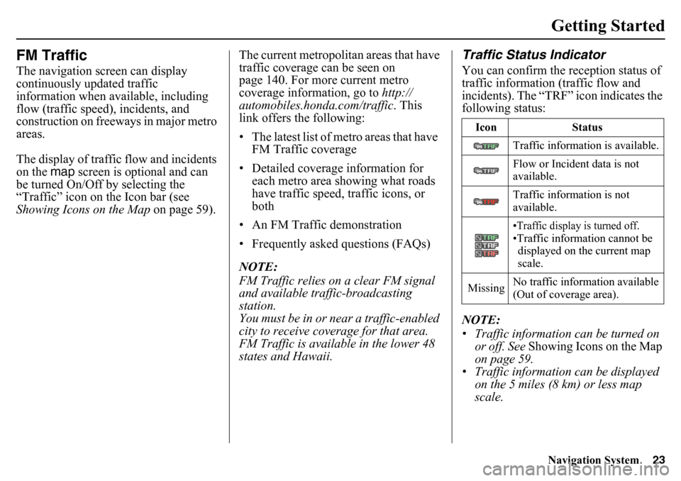
Traffic Status IndicatorYou can confirm the reception status of
traffic information (traffic flow and
incidents). The “TRF” icon indicates the
following status:
NOTE:
• Traffic information can be turned on or off. See Showing Icons on the Map
on page 59.
• Traffic information can be displayed on the 5 miles (8 km) or less map
scale.
Icon Status
Traffic information is available.
Flow or Incident data is not
available.
Traffic information is not
available.
•Traffic display is turned off.•Traffic information cannot be displayed on the current map
scale.
Missing No traffic information available
(Out of coverage area).
Page 26 of 175
26
Navigation System
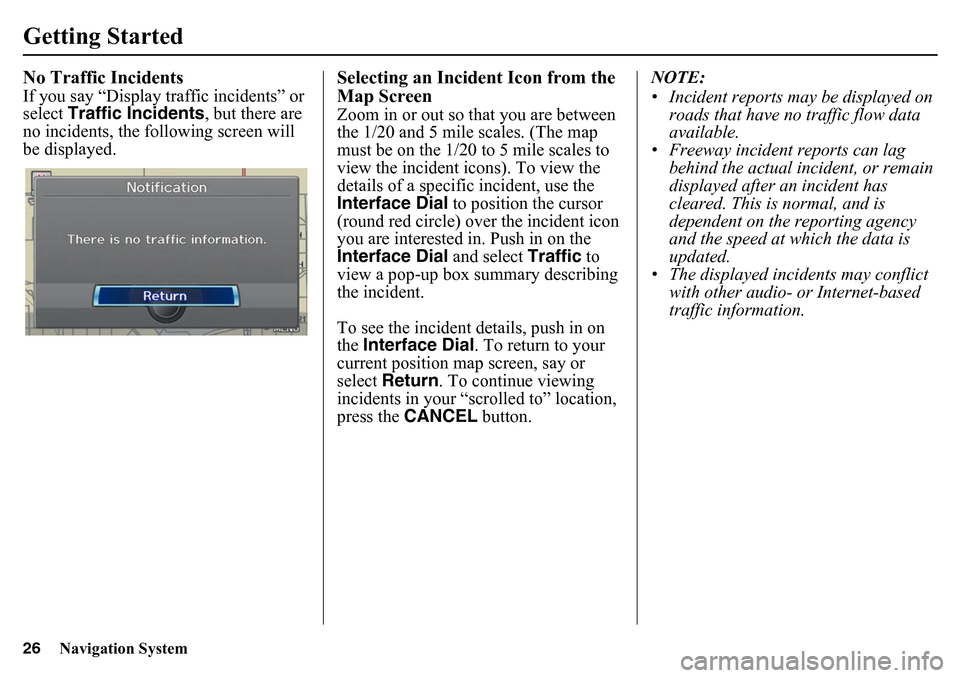
Getting StartedNo Traffic IncidentsIf you say “Display traffic incidents” or
select Traffic Incidents , but there are
no incidents, the following screen will
be displayed.
Selecting an Incident Icon from the
Map ScreenZoom in or out so that you are between
the 1/20 and 5 mile scales. (The map
must be on the 1/20 to 5 mile scales to
view the incident icons). To view the
details of a specific incident, use the
Interface Dial to position the cursor
(round red circle) over the incident icon
you are interested in. Push in on the
Interface Dial and select Traffic to
view a pop-up box summary describing
the incident.
To see the incident details, push in on
the Interface Dial . To return to your
current position map screen, say or
select Return . To continue viewing
incidents in your “scrolled to” location,
press the CANCEL button. NOTE:
• Incident reports may be displayed on
roads that have no traffic flow data
available.
• Freeway incident reports can lag
behind the actual incident, or remain
displayed after an incident has
cleared. This is normal, and is
dependent on the reporting agency
and the speed at which the data is
updated.
• The displayed incidents may conflict with other audio- or Internet-based
traffic information.
Page 31 of 175
Navigation System31
Entering a Destination
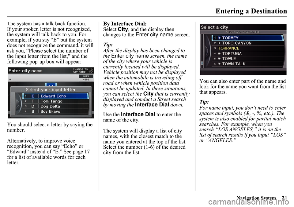
The system has a talk back function.
If your spoken letter is not recognized,
the system will talk back to you. For
example, if you say “E” but the system
does not recognize the command, it will
ask you, “Please select the number of
the input letter from the list,” and the
following pop-up box will appear:
You should select a letter by saying the
number.
Alternatively, to improve voice
recognition, you can say “Echo” or
“Edward” instead of “E.” See page 17
for a list of available words for each
letter.
By Interface Dial:Select City, and the display then
changes to the Enter city name screen.
Tip:
After the display has been changed to
the Enter city name screen, the name
of the city where your vehicle is
currently located will be displayed.
Vehicle position may not be displayed
when the automobile is traveling off
road or when vehicle position data
cannot be updated. In these situations,
you can select the City that is currently
displayed and conduct a Street search
by moving the Interface Dial down.
Use the Interface Dial to enter the
name of the city.
The system will display a list of city
names, with the closest match to the
name you entered at the top of the list.
Select the number (1-6) of the desired
city from the list. You can also enter part of the name and
look for the name you want from the list
that appears.
Tip:
For name input, you don’t need to enter
spaces and symbols (&, -, %, etc.). The
system is also enabled for partial match
searches. For example, when you
search “LOS ANGELES,” it is on the
list of search results if you input “LOS”
or “ANGELES.”
Page 64 of 175
64
Navigation System
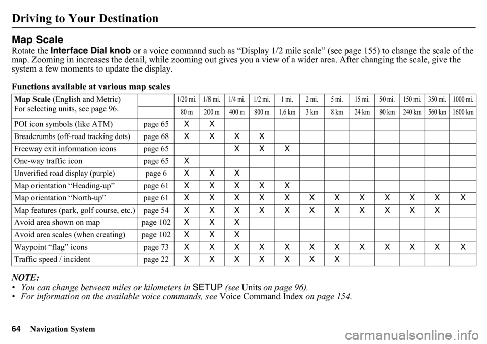
Driving to Your DestinationMap ScaleRotate the Interface Dial knob or a voice command such as “Display 1/2 mile scale” (see page 155) to change the scale of the
map. Zooming in increases the detail, while zooming out gives you a view of a wider area. After changing the scale, give the
system a few moments to update the display.
Functions available at various map scales
NOTE:
• You can change between miles or kilometers in SETUP (see Units on page 96).
• For information on the av ailable voice commands, see Voice Command Index on page 154.Map Scale (English and Metric)
For selecting units, see page 96.
1/20 mi. 1/8 mi. 1/4 mi. 1/2 mi. 1 mi. 2 mi. 5 mi. 15 mi. 50 mi. 150 mi. 350 mi. 1000 mi.80 m 200 m 400 m 800 m 1.6 km 3 km 8 km 24 km 80 km 240 km 560 km 1600 km
POI icon symbols (like ATM) page 65 XXBreadcrumbs (off-road tracking dots)
page 68XXXX
Freeway exit information icons page 65 XXX
One-way traffic icon page 65 X
Unverified road display (purple)
page 6XXX
Map orientation “Heading-up” page 61 XXXXX
Map orientation “North-up” page 61 XXXXXXXXXXX X
Map features (park, golf course, etc.) page 54 XXXXXXXXXXX
Avoid area shown on map page 102 XXX
Avoid area scales (when creating) page 102 XXX
Waypoint “flag” icons page 73 XXXXXXXXXXX X
Traffic speed / incident page 22 XXXXXXX
Page 79 of 175
Navigation System79
Information Features
NOTE:
When you cannot receive Traffic
Incidents information and select this
feature, the message “Traffic
information could not be received” will
be displayed. The traffic information
will be automatically updated every 5
minutes.
Clock/WallpaperThe Clock/Wallpaper option allows
you to set up the clock screen or choose
a wallpaper image to display. See
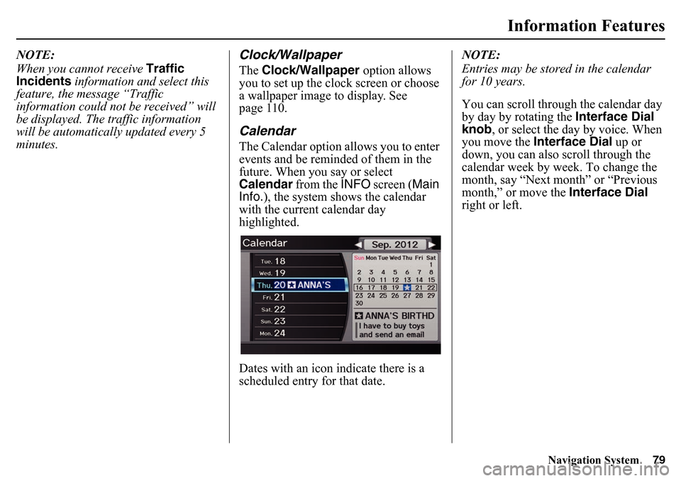
page 110.CalendarThe Calendar option allows you to enter
events and be reminded of them in the
future. When you say or select
Calendar from the INFO screen ( Main
Info. ), the system shows the calendar
with the current calendar day
highlighted.
Dates with an icon indicate there is a
scheduled entry for that date. NOTE:
Entries may be stored
in the calendar
for 10 years.
You can scroll through the calendar day
by day by rotating the Interface Dial
knob , or select the day by voice. When
you move the Interface Dial up or
down, you can also scroll through the
calendar week by week. To change the
month, say “Next month” or “Previous
month,” or move the Interface Dial
right or left.
Page 84 of 175
84
Navigation System
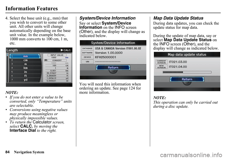
Information Features4. Select the base unit (e.g., mm) that you wish to convert to some other
unit. All other units will change
automatically depe nding on the base
unit value. In the example below,
1000 mm converts to 100 cm, 1 m,
etc.
NOTE:
• If you do not enter a value to be converted, only “Temperature” units
are selectable.
• Conversions using negative values may produce meaningless or
physically impossible values.
• To return the Calculator screen,
select CALC. by moving the
Interface Dial to the right.
System/Device InformationSay or select System/Device
Information on the INFO screen
(Other ), and the display will change as
indicated below.
You will need this information when
ordering an update. See page 124 for
more information.
Map Data Update StatusDuring data updates, you can check the
update status for map data.
During the update of map data, say or
select Map Data Update Status on
the INFO screen ( Other), and the
display will change as indicated below.
NOTE:
This operation can only be carried out
during a disc update.