INFINITI QX80 2020 Infiniti Connection
Manufacturer: INFINITI, Model Year: 2020, Model line: QX80, Model: INFINITI QX80 2020Pages: 276, PDF Size: 1.16 MB
Page 191 of 276
![INFINITI QX80 2020 Infiniti Connection [Never Use]Calculates route avoiding the use of seasonal restricted
roads.
[Use Traffic Informa-
tion] [Auto]
Calculates the route automatically taking traffic information
into consideration.
[Accept] INFINITI QX80 2020 Infiniti Connection [Never Use]Calculates route avoiding the use of seasonal restricted
roads.
[Use Traffic Informa-
tion] [Auto]
Calculates the route automatically taking traffic information
into consideration.
[Accept]](/img/42/35001/w960_35001-190.png)
[Never Use]Calculates route avoiding the use of seasonal restricted
roads.
[Use Traffic Informa-
tion] [Auto]
Calculates the route automatically taking traffic information
into consideration.
[Accept] If a traffic jam or incident occurs, a confirmation screen will
appear before calculation.
[OFF] Calculates the route without taking traffic information into
consideration.
[Use Avoid Area Settings] When enabled, the system avoids the previously defined
avoid areas.
[Use Ferries] Includes the use of ferries.
[Use Car-Carrying Trains] Includes the use of car-carrying trains.
[Use Unpaved Roads] Includes the use of unpaved roads.
[Use HOV Lanes] Includes the use of HOV lanes.
[Use Learned Routes] Uses the roads that are most frequently traveled with the help
of self-learning technology.
[Customize More
Routes] [3types]
Calculates 3 types of route when confirming other routes.
[1type] Calculates an alternative route when confirming other routes.
[Estimated Time] [Destination] Displays the estimated time of arrival or remaining time to the
destination during route guidance.
[Waypoint] Displays the estimated time of arrival or remaining time to the
waypoint during the route guidance.
[Time Shown on Map] [ETA] Displays the estimated time of arrival.
[Remaining] Displays the remaining time to arrive.
6. Navigation (if so equipped)
6-35
Page 192 of 276

6. Navigation (if so equipped)
INFO:
. If the vehicle greatly deviates from the suggested route, the system calculates a new route.
. Traffic jam information displayed on the map screen is not statistical traffic information.
. If [Ignore Restrictions] is selected for [Time Restricted Roads] setting, the system calculates a route without any consideration of the
regulations concerning the time or day of the week. Therefore, the suggested route may include a road subject to traffic regulations
concerning the time or day of the week. When driving along the route, always follow all traffic regulations regardless of whether [Time
Restricted Roads] is set to be considered or not.
. Even when [Use Traffic Information] is turned on, if traffic information has not been provided for the area, a detour may not always be
indicated in a location where a traffic jam occurs.
. The system calculates to reduce the time required for the entire route from the start to the destination. If there are no appropriate routes,
the system may lead to a route where a traffic jam occurs instead of leading to a detour.
. The system may not lead to a detour if the traffic closure or a traffic jam occurs far from the present location.
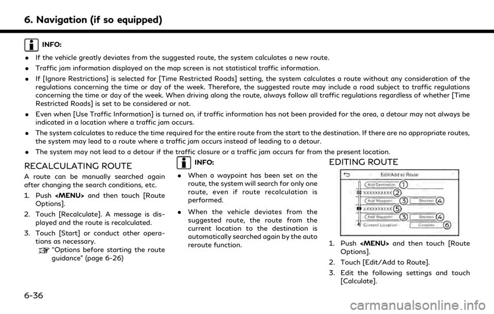
RECALCULATING ROUTE
A route can be manually searched again
after changing the search conditions, etc.
1. Push
Page 193 of 276
![INFINITI QX80 2020 Infiniti Connection Available setting items
[Add Destination]:
Touch to add a new destination.
Current destination:
Touch to edit or delete the destination.
“Editing/deleting destination or
waypoint” (page 6-37)
[Add INFINITI QX80 2020 Infiniti Connection Available setting items
[Add Destination]:
Touch to add a new destination.
Current destination:
Touch to edit or delete the destination.
“Editing/deleting destination or
waypoint” (page 6-37)
[Add](/img/42/35001/w960_35001-192.png)
Available setting items
[Add Destination]:
Touch to add a new destination.
Current destination:
Touch to edit or delete the destination.
“Editing/deleting destination or
waypoint” (page 6-37)
[Add Waypoint]:
Touch to add a waypoint.
“Setting destination or waypoint”
(page 6-37)
Criteria for calculating a route to the
destination/waypoint:
Touch to change the conditions for
route calculation.
“Changing route calculation condi-
tions” (page 6-38)
Current waypoint:
Touch to edit or delete the waypoint.
“Editing/deleting destination or
waypoint” (page 6-37)
[Calculate]:
After editing the route, touch to recal-
culate a route with new conditions.
Setting destination or waypoint
A destination or waypoint can be added to a
route that has already been set. Up to 14
waypoints besides one destination can be
set.
1. Push
Options].
2. Touch [Edit/Add to Route].
3. Touch [Add Destination] or [Add Way- point].
INFO:
If [Add Destination] is selected, the
current destination changes to a way-
point.
4. Set a destination or waypoint. The method of searching for a destination
or waypoint is the same as the one for a
destination.
“Setting destination” (page 6-14)
5. Touch [Add to Route] to add the location to the route.
6. The route information with the selected location added to the route is displayed.
Adjust the route calculation conditions
as necessary.
“Changing route calculation condi-
tions” (page 6-38)
7. Touch [Calculate] to confirm the route change. The route will be recalculated.
INFO:
. The prior route will be deleted automa-
tically.
. Destination or waypoint can also be
added from the shortcut menu.
“Shortcut menu” (page 2-13)
Editing/deleting destination or
waypoint
A destination or waypoint that has already
been set can be modified or deleted.
1. Push
Options].
6. Navigation (if so equipped)
6-37
Page 194 of 276
![INFINITI QX80 2020 Infiniti Connection 6. Navigation (if so equipped)
2. Touch [Edit/Add to Route].
3. Touch a destination or waypoint that isalready set.
4. Touch to edit the following settings: Available setting items
.[Delete]:A selecte INFINITI QX80 2020 Infiniti Connection 6. Navigation (if so equipped)
2. Touch [Edit/Add to Route].
3. Touch a destination or waypoint that isalready set.
4. Touch to edit the following settings: Available setting items
.[Delete]:A selecte](/img/42/35001/w960_35001-193.png)
6. Navigation (if so equipped)
2. Touch [Edit/Add to Route].
3. Touch a destination or waypoint that isalready set.
4. Touch to edit the following settings: Available setting items
.[Delete]:A selected destination or waypoint
that has already been set can be
deleted.
.[Change Order]:The order of a destination and way-
points that are already set can be
changed.
.[Move Destination]:The location of the destination or
waypoint can be adjusted by moving
the cross pointer across the map on
the touch screen display.
5. Touch [Calculate] to apply the change.
INFO:
If the destination is deleted, the route
guidance will be canceled.
Changing route calculation condi-
tions
Each section of the route between way-
points can have different route calculation
conditions.
1. Push
Options].
2. Touch [Edit/Add to Route].
3. Touch the route condition shown on the preferred section of the route to the
destination or waypoint.
4. Touch the preferred condition. Available setting items
.[Fastest Route]:Prioritizes the use of fastest route.
.[Energy-Saving]:Prioritizes a route which uses less
energy.
.[Shortest Distance]:Prioritizes the shortest route. The
route may not be the shortest be-
cause the system prioritizes roads
that are easy to drive on for safety
reasons.
5. The conditions are changed. Touch [
]
to return to the edit route screen. 6. Touch [Calculate] to apply the change.
INFO:
The recalculated route may not be the
shortest route because the system priori-
tizes roads that are easy to drive on for
safety reasons.
Changing order of destination and
waypoints
The order of a destination and waypoints
that are already set can be changed.
1. Push
Options].
2. Touch [Edit/Add to Route].
3. Touch a destination or waypoint that is already set.
4. Touch [Change Order].
6-38
Page 195 of 276
![INFINITI QX80 2020 Infiniti Connection 5. Touch a preferred destination or way-point to replace the previously selected
destination or waypoint.
6. Touch [Calculate] to apply the change.
6. Navigation (if so equipped)
6-39 INFINITI QX80 2020 Infiniti Connection 5. Touch a preferred destination or way-point to replace the previously selected
destination or waypoint.
6. Touch [Calculate] to apply the change.
6. Navigation (if so equipped)
6-39](/img/42/35001/w960_35001-194.png)
5. Touch a preferred destination or way-point to replace the previously selected
destination or waypoint.
6. Touch [Calculate] to apply the change.
6. Navigation (if so equipped)
6-39
Page 196 of 276
![INFINITI QX80 2020 Infiniti Connection 6. Navigation (if so equipped)
GUIDANCE SETTINGS
Various settings are available to customize the guidance information provided by the system.
1. Push<MENU> and touch [Settings].
2. Touch [Navigation] INFINITI QX80 2020 Infiniti Connection 6. Navigation (if so equipped)
GUIDANCE SETTINGS
Various settings are available to customize the guidance information provided by the system.
1. Push<MENU> and touch [Settings].
2. Touch [Navigation]](/img/42/35001/w960_35001-195.png)
6. Navigation (if so equipped)
GUIDANCE SETTINGS
Various settings are available to customize the guidance information provided by the system.
1. Push
2. Touch [Navigation] and touch [Guidance Settings].
3. Touch an item you would like to set.
Setting item Action
[Guidance Volume] Adjusts the volume level of voice guidance.
[Guidance Voice] Activates or deactivates voice guidance.
[Traffic Announcement] Activates or deactivates the traffic announcement.
When this item is activated, the system provides an announcement of traffic information
or events on the route. The indicator illuminates if traffic announcement is activated.
[Toll Booth Guide] Activates or deactivates the function to notify that the vehicle is approaching a toll booth.
INFO:
. [Guidance Settings] can also be accessed from the route options screen.
“Route options menu” (page 6-30)
. The guidance volume can also be adjusted by turning
announced.
6-40
Page 197 of 276

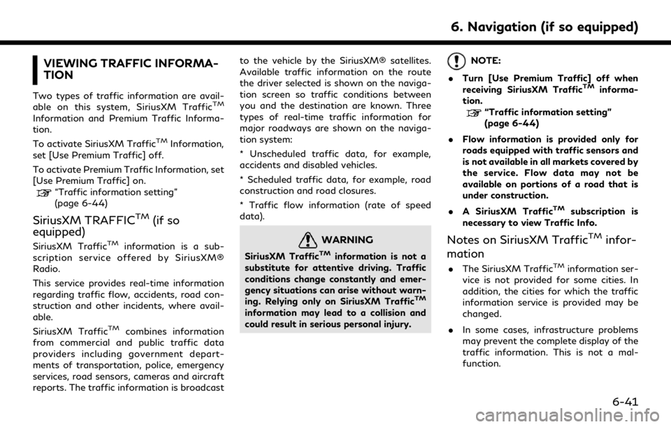
VIEWING TRAFFIC INFORMA-
TION
Two types of traffic information are avail-
able on this system, SiriusXM TrafficTM
Information and Premium Traffic Informa-
tion.
To activate SiriusXM Traffic
TMInformation,
set [Use Premium Traffic] off.
To activate Premium Traffic Information, set
[Use Premium Traffic] on.
“Traffic information setting”
(page 6-44)
SiriusXM TRAFFICTM(if so
equipped)
SiriusXM TrafficTMinformation is a sub-
scription service offered by SiriusXM®
Radio.
This service provides real-time information
regarding traffic flow, accidents, road con-
struction and other incidents, where avail-
able.
SiriusXM Traffic
TMcombines information
from commercial and public traffic data
providers including government depart-
ments of transportation, police, emergency
services, road sensors, cameras and aircraft
reports. The traffic information is broadcast to the vehicle by the SiriusXM® satellites.
Available traffic information on the route
the driver selected is shown on the naviga-
tion screen so traffic conditions between
you and the destination are known. Three
types of real-time traffic information for
major roadways are shown on the naviga-
tion system:
* Unscheduled traffic data, for example,
accidents and disabled vehicles.
* Scheduled traffic data, for example, road
construction and road closures.
* Traffic flow information (rate of speed
data).
WARNING
SiriusXM TrafficTMinformation is not a
substitute for attentive driving. Traffic
conditions change constantly and emer-
gency situations can arise without warn-
ing. Relying only on SiriusXM Traffic
TM
information may lead to a collision and
could result in serious personal injury.
NOTE:
. Turn [Use Premium Traffic] off when
receiving SiriusXM Traffic
TMinforma-
tion.
“Traffic information setting”
(page 6-44)
. Flow information is provided only for
roads equipped with traffic sensors and
is not available in all markets covered by
the service. Flow data may not be
available on portions of a road that is
under construction.
. A SiriusXM Traffic
TMsubscription is
necessary to view Traffic Info.
Notes on SiriusXM TrafficTMinfor-
mation
. The SiriusXM TrafficTMinformation ser-
vice is not provided for some cities. In
addition, the cities for which the traffic
information service is provided may be
changed.
. In some cases, infrastructure problems
may prevent the complete display of the
traffic information. This is not a mal-
function.
6. Navigation (if so equipped)
6-41
Page 198 of 276

6. Navigation (if so equipped)
.Depending on the traffic information, a
detour route may be slower than the
original route.
. SiriusXM® Radio and SiriusXM Traffic
TM
subscriptions are sold separately or as a
package, and are continuous until you
call SiriusXM® to cancel. See SiriusXM®
Customer Agreement for complete
terms at the SiriusXM® website.
SiriusXM® website:
For U.S.
www. siriusxm.com
For Canada
www.siriusxm.ca (English)
www.siriusxm.ca/fr (French)
. SiriusXM® Travel Link is available in
select markets. For more information,
refer to the SiriusXM® website or call
Listener Care.
SiriusXM® website:
For U.S.
www.siriusxm.com/infotainment
For Canada
http://www.siriusxm.ca/siriusxm-traf-
fic-services/ (English) http://www.siriusxm.ca/fr/services-
siriusxm-traffic/ (French)
Listener Care:
For U.S.
1-877-447-0011
For Canada
1-877-438-9677
. SiriusXM Traffic
TMis available in over
130 metropolitan markets. For the most
current list of markets covered, please
refer to the SiriusXM® website or call
Listener Care.
SiriusXM® website:
For U.S.
www.siriusxm.com/infotainment
For Canada
http://www.siriusxm.ca/siriusxm-traf-
fic-services/ (English)
http://www.siriusxm.ca/fr/services-
siriusxm-traffic/ (French)
Listener Care:
For U.S.
1-877-447-0011
For Canada
1-877-438-9677 .
Due to road maintenance, infrastructure
problems (e.g. malfunction of road sen-
sors, outage of central computer of
infrastructure) or natural disasters, there
are times when some or all traffic
information may not be available.
. Incident information is based on human
collection. Not all incidents that have
happened are collected and provided.
. Due to the coverage and quality of traffic
information and road conditions, it is not
always possible for the system to pro-
vide the shortest time route even when
traffic information is considered.
. Traffic information that is displayed may
differ from information from other media
(e.g., radio), as other media may use
different information sources.
PREMIUM TRAFFIC INFORMA-
TION
Real-time traffic information can also be
obtained from Premium Traffic information
with more street coverage using the TCU
(Telematics Control Unit) installed in your
vehicle.
The types of event displayed on the screen
are the same as SiriusXM Traffic
TMInforma-
6-42
Page 199 of 276
![INFINITI QX80 2020 Infiniti Connection tion.
Premium Traffic information is available by
turning [Use Premium Traffic] on.
“Traffic information setting”
(page 6-44)
VIEWING AVAILABLE TRAFFIC
INFORMATION
Viewing traffic events from list INFINITI QX80 2020 Infiniti Connection tion.
Premium Traffic information is available by
turning [Use Premium Traffic] on.
“Traffic information setting”
(page 6-44)
VIEWING AVAILABLE TRAFFIC
INFORMATION
Viewing traffic events from list](/img/42/35001/w960_35001-198.png)
tion.
Premium Traffic information is available by
turning [Use Premium Traffic] on.
“Traffic information setting”
(page 6-44)
VIEWING AVAILABLE TRAFFIC
INFORMATION
Viewing traffic events from list
1. Push
[Information].
2. Touch [SXM Traffic] or [Premium Traf- fic]. A list of available types of informa-
tion is displayed.
Available
items Function
[Show the
Traffic on
the Route] Displays a list of traffic infor-
mation found on the route from
the current vehicle location to
the destination. Available only
when a route is set.
[Nearby
Traffic
Info] Displays a list of available traffic
information around the current
vehicle location.
INFO:
[SXM Traffic] or [Premium Traffic] is
available only when the traffic informa-
tion is received.
3. Touch the preferred item. A list of available events are displayed.
4. Touch an event from the list to check the
detailed information and the map. Touch
[Avoid] to search for an alternate route.
Displaying urgent traffic informa-
tion
When an urgent event is found around the
current vehicle location, a message pops up
automatically on the upper display with a
voice announcement.
The message includes the icon, event type,
event information and the direct distance
from the current location to the event.
INFO:
. When there are multiple urgent events,
the event with the shortest direct dis-
tance from the current location is dis-
played.
. If the urgent event is on the recom-
mended route, and if a detour is found,
the detour route notification screen is
displayed when the vehicle approaches
the detour point.
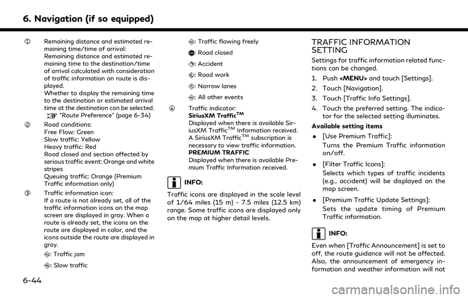
Traffic information on map
Traffic information is displayed on both 2D
and 3D map screens.
Screen information
Example
6. Navigation (if so equipped)
6-43
Page 200 of 276

6. Navigation (if so equipped)
Remaining distance and estimated re-
maining time/time of arrival:
Remaining distance and estimated re-
maining time to the destination/time
of arrival calculated with consideration
of traffic information on route is dis-
played.
Whether to display the remaining time
to the destination or estimated arrival
time at the destination can be selected.
“Route Preference” (page 6-34)
Road conditions:
Free Flow: Green
Slow traffic: Yellow
Heavy traffic: Red
Road closed and section affected by
serious traffic event: Orange and white
stripes
Queuing traffic: Orange (Premium
Traffic information only)
Traffic information icon:
If a route is not already set, all of the
traffic information icons on the map
screen are displayed in gray. When a
route is already set, the icons on the
route are displayed in color, and the
icons outside the route are displayed in
gray.
: Traffic jam
: Slow traffic
: Traffic flowing freely
: Road closed
: Accident
: Road work
: Narrow lanes
: All other events
Traffic indicator:
SiriusXM TrafficTM
Displayed when there is available Sir-
iusXM TrafficTMInformation received.
A SiriusXM TrafficTMsubscription is
necessary to view traffic information.
PREMIUM TRAFFIC
Displayed when there is available Pre-
mium Traffic Information received.
INFO:
Traffic icons are displayed in the scale level
of 1/64 miles (15 m) - 7.5 miles (12.5 km)
range. Some traffic icons are displayed only
on the map at higher detail levels.
TRAFFIC INFORMATION
SETTING
Settings for traffic information related func-
tions can be changed.
1. Push
2. Touch [Navigation].
3. Touch [Traffic Info Settings].
4. Touch the preferred setting. The indica- tor for the selected setting illuminates.
Available setting items . [Use Premium Traffic]:
Turns the Premium Traffic information
on/off.
. [Filter Traffic Icons]:
Selects which types of traffic incidents
(e.g., accident) will be displayed on the
map screen.
. [Premium Traffic Update Settings]:
Sets the update timing of Premium
Traffic information.
INFO:
Even when [Traffic Announcement] is set to
off, the route guidance will not be affected.
Also, the announcement of emergency in-
formation and weather information will not
6-44