navigation system Lexus ES300h 2015 Navigation Manual
[x] Cancel search | Manufacturer: LEXUS, Model Year: 2015, Model line: ES300h, Model: Lexus ES300h 2015Pages: 409, PDF Size: 24.08 MB
Page 78 of 409
77
3. OTHER SETTINGS
ES350/300h_Navi_OM33B43U_(U)14.06.23 09:44
BASIC FUNCTION
2
1Display the “Vehicle Settings” screen.
(→ P.76)
2Select “Maintenance” .
3Select the desired item.
MAINTENANCE
When the navigation system is turned
on, the “Maintenance Reminder” screen
displays when it is time to replace a part
or certain components. ( →P.37)
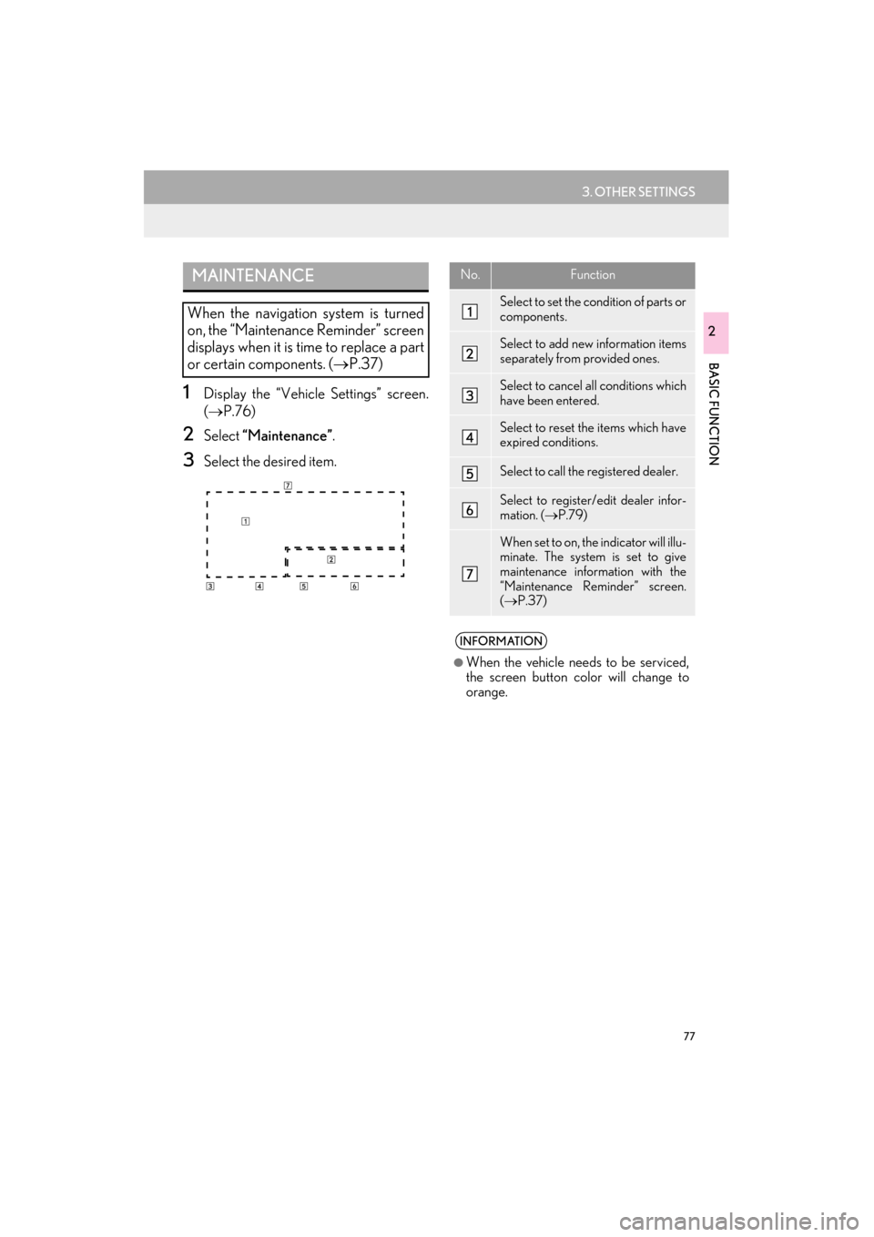
No.Function
Select to set the condition of parts or
components.
Select to add new information items
separately from provided ones.
Select to cancel all conditions which
have been entered.
Select to reset the items which have
expired conditions.
Select to call the registered dealer.
Select to register/edit dealer infor-
mation. ( →P.79)
When set to on, the indicator will illu-
minate. The system is set to give
maintenance information with the
“Maintenance Reminder” screen.
(→ P.37)
INFORMATION
●
When the vehicle needs to be serviced,
the screen button color will change to
orange.
Page 84 of 409
3
83
ES350/300h_Navi_OM33B43U_(U)14.06.23 09:44
1
2
3 4
5
6
7
8 9
1. ROUTE GUIDANCE SCREEN .......... 127
SCREEN FOR ROUTE GUIDANCE ............ 127
ROUTE OVERVIEW ............................................. 129
DURING FREEWAY DRIVING....................... 130
WHEN APPROACHING INTERSECTION ................................................... 132
TURN LIST SCREEN.............................................. 132
TURN-BY-TURN ARROW SCREEN ........... 133
2. TYPICAL VOICE GUIDANCE PROMPTS ............................................... 134
3. EDITING ROUTE..................................... 135
ADDING DESTINATIONS ................................ 136
REORDERING DESTINATIONS.................... 137
DELETING DESTINATIONS ............................ 137
SETTING ROUTE PREFERENCES................ 138
SELECTING ROUTE TYPE ............................... 138
DETOUR SETTING ................................................ 139
STARTING FROM ADJACENT ROAD...... 140
1. MEMORY POINTS SETTINGS........... 141
SETTING UP HOME ............................................. 142
SETTING UP PRESET DESTINATIONS ...... 144
SETTING UP ADDRESS BOOK ..................... 146
SETTING UP AREAS TO AVOID................... 149
DELETING PREVIOUS DESTINATIONS ................................................... 152
1. DETAILED NAVIGATION SETTINGS ................................................ 153
SCREENS FOR NAVIGATION
SETTINGS ................................................................ 154
2. TRAFFIC SETTINGS ............................... 159
SCREEN FOR TRAFFIC SETTINGS.............. 160
AUTO AVOID TRAFFIC ...................................... 161
1. GPS (GLOBAL POSITIONING SYSTEM) .................................................. 162
LIMITATIONS OF THE NAVIGATION
SYSTEM .................................................................... 162
2. MAP DATABASE VERSION AND COVERED AREA................................. 165
MAP INFORMATION .......................................... 165
ABOUT THE MAP DATA ................................... 166
3ROUTE GUIDANCE4MEMORY POINTS
5SETUP
6TIPS FOR THE NAVIGATION
SYSTEM
NAVIGATION SYSTEM
Page 85 of 409
84
ES350/300h_Navi_OM33B43U_(U)14.06.23 09:44
1. BASIC OPERATION
1. QUICK REFERENCE
MAP SCREEN
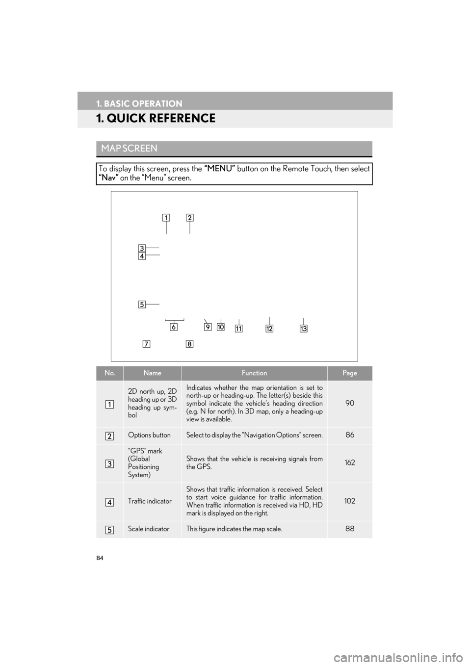
To display this screen, press the “MENU” button on the Remote Touch, then select
“Nav” on the “Menu” screen.
No.NameFunctionPag e
2D north up, 2D
heading up or 3D
heading up sym-
bolIndicates whether the map orientation is set to
north-up or heading-up. The letter(s) beside this
symbol indicate the vehi cle’s heading direction
(e.g. N for north). In 3D map, only a heading-up
view is available.
90
Options buttonSelect to display the “Navigation Options” screen.86
“GPS” mark
(Global
Positioning
System)Shows that the vehicle is receiving signals from
the GPS.162
Traffic indicator
Shows that traffic inform ation is received. Select
to start voice guidance for traffic information.
When traffic information is received via HD, HD
mark is displayed on the right.
102
Scale indicatorThis figure indicates the map scale.88
Page 86 of 409
85
1. BASIC OPERATION
ES350/300h_Navi_OM33B43U_(U)14.06.23 09:44
NAVIGATION SYSTEM
3
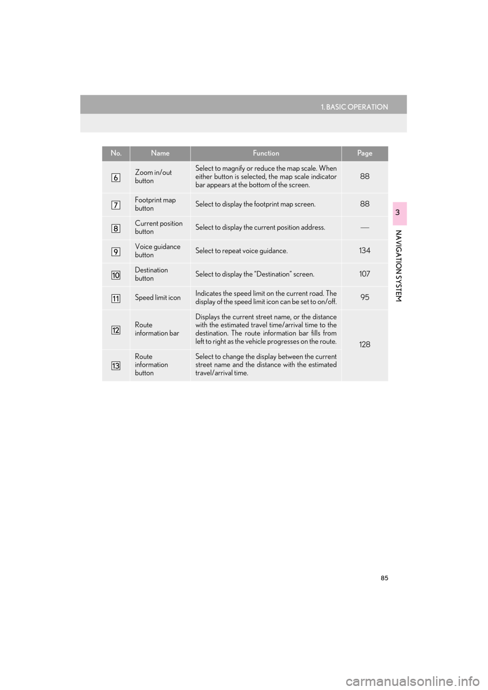
Zoom in/out
buttonSelect to magnify or reduce the map scale. When
either button is selected, the map scale indicator
bar appears at the bottom of the screen.
88
Footprint map
buttonSelect to display the footprint map screen.88
Current position
buttonSelect to display the current position address.
Voice guidance
buttonSelect to repeat voice guidance.134
Destination
buttonSelect to display the “Destination” screen. 107
Speed limit iconIndicates the speed limit on the current road. The
display of the speed limit icon can be set to on/off.95
Route
information barDisplays the current street name, or the distance
with the estimated travel time/arrival time to the
destination. The route information bar fills from
left to right as the vehicle progresses on the route.
128
Route
information
buttonSelect to change the display between the current
street name and the distance with the estimated
travel/arrival time.
No.NameFunctionPa g e
Page 88 of 409
87
1. BASIC OPERATION
ES350/300h_Navi_OM33B43U_(U)14.06.23 09:44
NAVIGATION SYSTEM
3
2. MAP SCREEN OPERATION
1Press the “MENU” button on the
Remote Touch.
2Select “Nav”.
3Check that the current position map is
displayed.
CURRENT POSITION DISPLAY
�zTo correct the current position manually:
→P.1 5 7
INFORMATION
●
While driving, the cu rrent position mark
is fixed on the screen and the map moves.
●The current position is automatically set
as the vehicle receives signals from the
GPS (Global Positioning System). If the
current position is not correct, it is auto-
matically corrected after the vehicle
receives signals from the GPS.
●After the battery disconnection, or on a
new vehicle, the current position may not
be correct. As soon as the system
receives signals from the GPS, the cor-
rect current position is displayed.
Page 90 of 409

89
1. BASIC OPERATION
ES350/300h_Navi_OM33B43U_(U)14.06.23 09:44
NAVIGATION SYSTEM
3
�zTo display the normal map, select .
1Select an arrow to rotate.
3D CITY MODEL MAP
A 3D city model map can be displayed
for some areas in major cities when the
map scale is 700 ft. (200 m) or less on
the 3D map screen.
INFORMATION
●
The 3D city model map can be set the
display on/off. ( →P.1 5 3 )
ROTATING 3D MAP
3D map and 3D city model map can be
rotated when arrows appear around the
cursor while scrolling.
INFORMATION
●
The viewing angle of the 3D map can be
changed. ( →P.1 5 6 )
Page 92 of 409

91
1. BASIC OPERATION
ES350/300h_Navi_OM33B43U_(U)14.06.23 09:44
NAVIGATION SYSTEM
3
1Select “Options” on the map screen.
2Select “Map Mode”.
3Select the desired configuration button.
�zDepending on the conditions, certain
screen configuration buttons cannot be
selected.
SWITCHING THE MAP MODENo.FunctionPage
Select to display the single
map screen. 92
Select to display the dual
map screen.92
Select to display the com-
pass mode screen.93
Select to display the turn list
screen.132
Select to display the freeway
exit list screen.130
Select to display the inter-
section guidance screen or
the guidance screen on the
freeway.
132
Select to display the turn-
by-turn arrow screen.133
Page 94 of 409
93
1. BASIC OPERATION
ES350/300h_Navi_OM33B43U_(U)14.06.23 09:44
NAVIGATION SYSTEM
3
■COMPASS
Information about the destination, cur-
rent position and a compass is displayed
on the screen.
INFORMATION
●
The destination mark is displayed in the
direction of the destination. When driv-
ing, refer to the longitude and latitude
coordinates, and the compass, to make
sure that the vehicle is headed in the
direction of the destination.
●When the vehicle travels out of the cover-
age area, the guidance screen changes to
the whole compass mode screen.
SCREEN SCROLL
OPERATION
Use the scroll feature to move the de-
sired point to the center of the screen for
looking at a point on the map that is dif-
ferent from the current position.
No.Information/Function
Cursor mark
Distance from the current position to
the cursor mark.
Select to set as a destination.
When selecting “Go to ” on the fol-
lowing map screen, the navigation
system performs a search for the
route. ( →P.123)
If a destination has already been set,
“Go to ” and “Add to Route” will be
displayed.
“Go to ” : Select to delete the exist-
ing destination(s) and set a new one.
“Add to Route” : Select to add a desti-
nation.
Select to register as a memory point.
To change the icon, name, etc.:→P.146
Select to return to the current posi-
tion.
Page 96 of 409
95
1. BASIC OPERATION
ES350/300h_Navi_OM33B43U_(U)14.06.23 09:44
NAVIGATION SYSTEM
3
3. MAP SCREEN INFORMATION
1Select “Options” on the map screen.
2Select “Map Information” .
3Select the desired items to be displayed.
�zWhen set to on, the indicator will illuminate.
DISPLAYING MAP
INFORMATION
Information such as POI icons, route
trace, speed limit, etc. can be displayed
on the map screen.
No.FunctionPage
Select to display the select-
ed POI icons.
Select to select or change
POI icons.96
Select to display eDestina-
tion icons.376
Select to display route trace.98
Select to display traffic infor-
mation.102
Select to display speed limit
icon.
Page 98 of 409
97
1. BASIC OPERATION
ES350/300h_Navi_OM33B43U_(U)14.06.23 09:44
NAVIGATION SYSTEM
3
■SELECTING OTHER POI ICONS
TO BE DISPLAYED
1Select “Other POIs” .
2Select the desired POI categories and
select “OK”.
“List All Categories” : Select to display all
POI categories. To add more POI catego-
ries, select “More”.
■DISPLAYING THE LOCAL POI
LIST
1Select “Find Local POI” .
2Select the desired POI.
“Near...” : Select to search for POIs near the
current position or along the route.
3Check that the selected POI is dis-
played on the map screen. ( →P.93)
POIs that are within 20 miles (32 km) of
the current position will be listed from
among the selected categories.