display Lexus GS450h 2012 Navigation manual
[x] Cancel search | Manufacturer: LEXUS, Model Year: 2012, Model line: GS450h, Model: Lexus GS450h 2012Pages: 257, PDF Size: 30.79 MB
Page 116 of 257
115
2. ROUTE GUIDANCE
GS450h/250 (EE) NAVI 30C48E
13.12.17 15:42
3
NAVIGATION SYSTEM
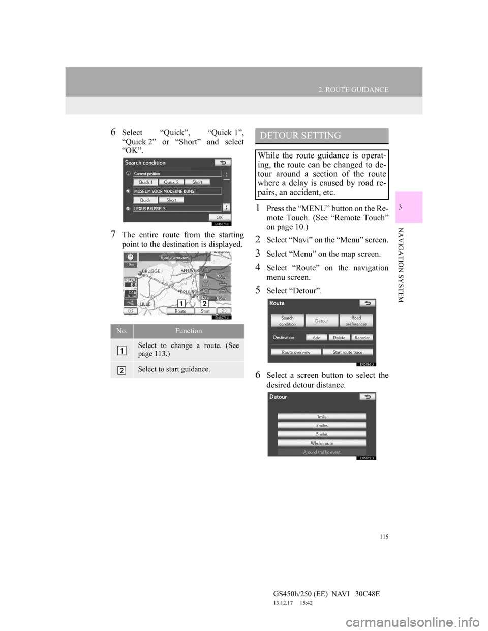
6Select “Quick”, “Quick 1”,
“Quick 2” or “Short” and select
“OK”.
7The entire route from the starting
point to the destination is displayed.
1Press the “MENU” button on the Re-
mote Touch. (See “Remote Touch”
on page 10.)
2Select “Navi” on the “Menu” screen.
3Select “Menu” on the map screen.
4Select “Route” on the navigation
menu screen.
5Select “Detour”.
6Select a screen button to select the
desired detour distance.
No.Function
Select to change a route. (See
page 113.)
Select to start guidance.
DETOUR SETTING
While the route guidance is operat-
ing, the route can be changed to de-
tour around a section of the route
where a delay is caused by road re-
pairs, an accident, etc.
Page 117 of 257
116
2. ROUTE GUIDANCE
GS450h/250 (EE) NAVI 30C48E
13.12.17 15:42
“1 km (mile)”, “3 km (miles)” or “5 km
(miles)”: Select one of these screen but-
tons to start the detour process. After de-
touring, the system returns to the
original guidance route.
“Whole route”: Select to make the sys-
tem calculate an entire new route to the
destination.
“Around traffic event”: Select to make
the system search for the route based on
the traffic congestion information re-
ceived.
1Press the “MENU” button on the Re-
mote Touch. (See “Remote Touch”
on page 10.)
2Select “Navi” on the “Menu” screen.
3Select “Menu” on the map screen.
4Select “Route” on the navigation
menu screen.
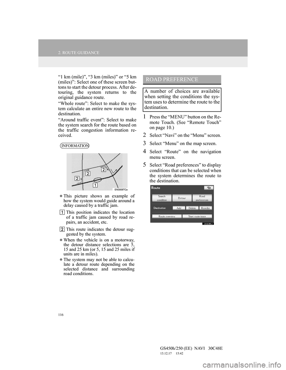
5Select “Road preferences” to display
conditions that can be selected when
the system determines the route to
the destination.
INFORMATION
This picture shows an example of
how the system would guide around a
delay caused by a traffic jam.
This position indicates the location
of a traffic jam caused by road re-
pairs, an accident, etc.
This route indicates the detour sug-
gested by the system.
When the vehicle is on a motorway,
the detour distance selections are 5,
15 and 25 km (or 5, 15 and 25 miles if
units are in miles).
The system may not be able to calcu-
late a detour route depending on the
selected distance and surrounding
road conditions.
ROAD PREFERENCE
A number of choices are available
when setting the conditions the sys-
tem uses to determine the route to the
destination.
Page 118 of 257
117
2. ROUTE GUIDANCE
GS450h/250 (EE) NAVI 30C48E
13.12.17 15:42
3
NAVIGATION SYSTEM
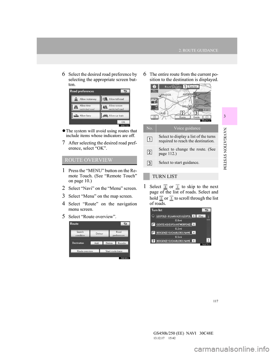
6Select the desired road preference by
selecting the appropriate screen but-
ton.
The system will avoid using routes that
include items whose indicators are off.
7After selecting the desired road pref-
erence, select “OK”.
1Press the “MENU” button on the Re-
mote Touch. (See “Remote Touch”
on page 10.)
2Select “Navi” on the “Menu” screen.
3Select “Menu” on the map screen.
4Select “Route” on the navigation
menu screen.
5Select “Route overview”.
6The entire route from the current po-
sition to the destination is displayed.
1Select or to skip to the next
page of the list of roads. Select and
hold or to scroll through the list
of roads.
ROUTE OVERVIEW
No.Voice guidance
Select to display a list of the turns
required to reach the destination.
Select to change the route. (See
page 112.)
Select to start guidance.
TURN LIST
Page 119 of 257
118
2. ROUTE GUIDANCE
GS450h/250 (EE) NAVI 30C48E
13.12.17 15:42
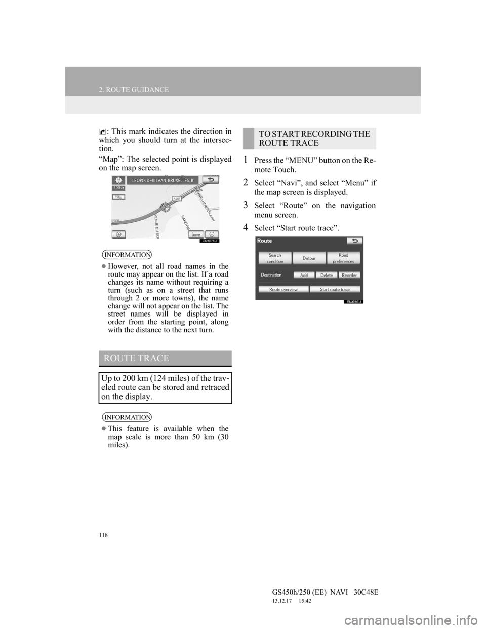
: This mark indicates the direction in
which you should turn at the intersec-
tion.
“Map”: The selected point is displayed
on the map screen.
1Press the “MENU” button on the Re-
mote Touch.
2Select “Navi”, and select “Menu” if
the map screen is displayed.
3Select “Route” on the navigation
menu screen.
4Select “Start route trace”.
INFORMATION
However, not all road names in the
route may appear on the list. If a road
changes its name without requiring a
turn (such as on a street that runs
through 2 or more towns), the name
change will not appear on the list. The
street names will be displayed in
order from the starting point, along
with the distance to the next turn.
ROUTE TRACE
Up to 200 km (124 miles) of the trav-
eled route can be stored and retraced
on the display.
INFORMATION
This feature is available when the
map scale is more than 50 km (30
miles).
TO START RECORDING THE
ROUTE TRACE
Page 120 of 257
119
2. ROUTE GUIDANCE
GS450h/250 (EE) NAVI 30C48E
13.12.17 15:42
3
NAVIGATION SYSTEM
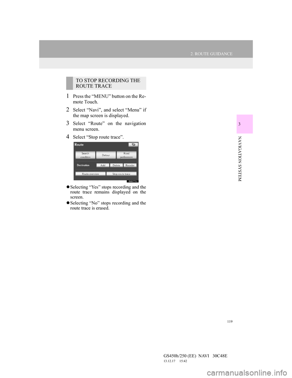
1Press the “MENU” button on the Re-
mote Touch.
2Select “Navi”, and select “Menu” if
the map screen is displayed.
3Select “Route” on the navigation
menu screen.
4Select “Stop route trace”.
Selecting “Yes” stops recording and the
route trace remains displayed on the
screen.
Selecting “No” stops recording and the
route trace is erased.
TO STOP RECORDING THE
ROUTE TRACE
Page 121 of 257
120
2. ROUTE GUIDANCE
GS450h/250 (EE) NAVI 30C48E
13.12.17 15:42
6. DISPLAY POI ICONS
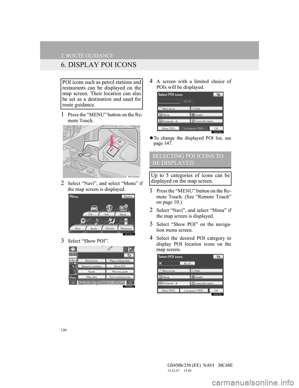
1Press the “MENU” button on the Re-
mote Touch.
2Select “Navi”, and select “Menu” if
the map screen is displayed.
3Select “Show POI”.
4A screen with a limited choice of
POIs will be displayed.
To change the displayed POI list, see
page 147.
1Press the “MENU” button on the Re-
mote Touch. (See “Remote Touch”
on page 10.)
2Select “Navi”, and select “Menu” if
the map screen is displayed.
3Select “Show POI” on the naviga-
tion menu screen.
4Select the desired POI category to
display POI location icons on the
map screen.
POI icons such as petrol stations and
restaurants can be displayed on the
map screen. Their location can also
be set as a destination and used for
route guidance.
SELECTING POI ICONS TO
BE DISPLAYED
Up to 5 categories of icons can be
displayed on the map screen.
Page 122 of 257
121
2. ROUTE GUIDANCE
GS450h/250 (EE) NAVI 30C48E
13.12.17 15:42
3
NAVIGATION SYSTEM
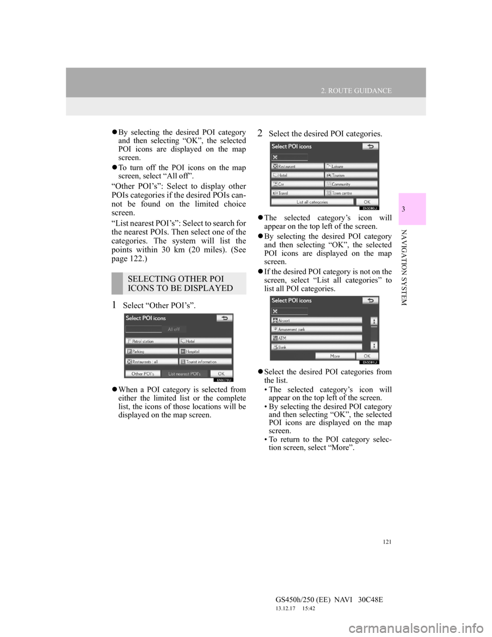
By selecting the desired POI category
and then selecting “OK”, the selected
POI icons are displayed on the map
screen.
To turn off the POI icons on the map
screen, select “All off”.
“Other POI’s”: Select to display other
POIs categories if the desired POIs can-
not be found on the limited choice
screen.
“List nearest POI’s”: Select to search for
the nearest POIs. Then select one of the
categories. The system will list the
points within 30 km (20 miles). (See
page 122.)
1Select “Other POI’s”.
When a POI category is selected from
either the limited list or the complete
list, the icons of those locations will be
displayed on the map screen.
2Select the desired POI categories.
The selected category’s icon will
appear on the top left of the screen.
By selecting the desired POI category
and then selecting “OK”, the selected
POI icons are displayed on the map
screen.
If the desired POI category is not on the
screen, select “List all categories” to
list all POI categories.
Select the desired POI categories from
the list.
• The selected category’s icon will
appear on the top left of the screen.
• By selecting the desired POI category
and then selecting “OK”, the selected
POI icons are displayed on the map
screen.
• To return to the POI category selec-
tion screen, select “More”.
SELECTING OTHER POI
ICONS TO BE DISPLAYED
Page 123 of 257
122
2. ROUTE GUIDANCE
GS450h/250 (EE) NAVI 30C48E
13.12.17 15:42
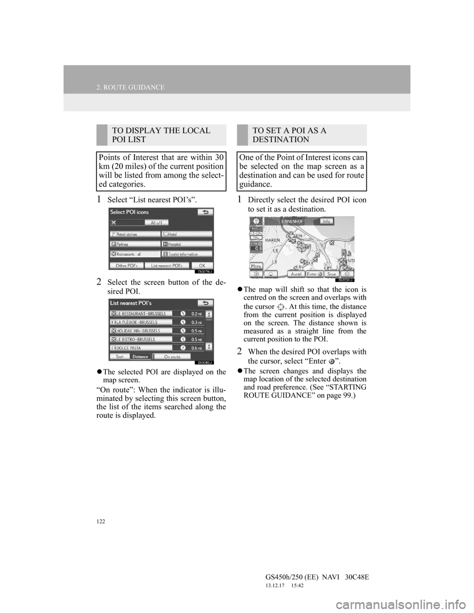
1Select “List nearest POI’s”.
2Select the screen button of the de-
sired POI.
The selected POI are displayed on the
map screen.
“On route”: When the indicator is illu-
minated by selecting this screen button,
the list of the items searched along the
route is displayed.
1Directly select the desired POI icon
to set it as a destination.
The map will shift so that the icon is
centred on the screen and overlaps with
the cursor . At this time, the distance
from the current position is displayed
on the screen. The distance shown is
measured as a straight line from the
current position to the POI.
2When the desired POI overlaps with
the cursor, select “Enter ”.
The screen changes and displays the
map location of the selected destination
and road preference. (See “STARTING
ROUTE GUIDANCE” on page 99.)
TO DISPLAY THE LOCAL
POI LIST
Points of Interest that are within 30
km (20 miles) of the current position
will be listed from among the select-
ed categories.TO SET A POI AS A
DESTINATION
One of the Point of Interest icons can
be selected on the map screen as a
destination and can be used for route
guidance.
Page 124 of 257
123
GS450h/250 (EE) NAVI 30C48E
13.12.17 15:42
3
NAVIGATION SYSTEM
3. MEMORY POINTS
1. MEMORY POINT SETTINGS
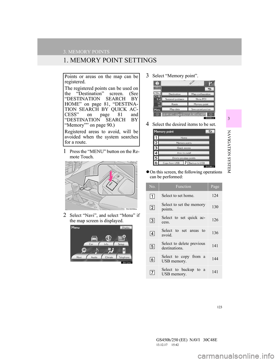
1Press the “MENU” button on the Re-
mote Touch.
2Select “Navi”, and select “Menu” if
the map screen is displayed.
3Select “Memory point”.
4Select the desired items to be set.
On this screen, the following operations
can be performed:
Points or areas on the map can be
registered.
The registered points can be used on
the “Destination” screen. (See
“DESTINATION SEARCH BY
HOME” on page 81, “DESTINA-
TION SEARCH BY QUICK AC-
CESS” on page 81 and
“DESTINATION SEARCH BY
“Memory”” on page 90.)
Registered areas to avoid, will be
avoided when the system searches
for a route.
No.FunctionPage
Select to set home.124
Select to set the memory
points.130
Select to set quick ac-
cess.126
Select to set areas to
avoid.136
Select to delete previous
destinations.141
Select to copy from a
USB memory.144
Select to backup to a
USB memory.141
Page 125 of 257
124
3. MEMORY POINTS
GS450h/250 (EE) NAVI 30C48E
13.12.17 15:42
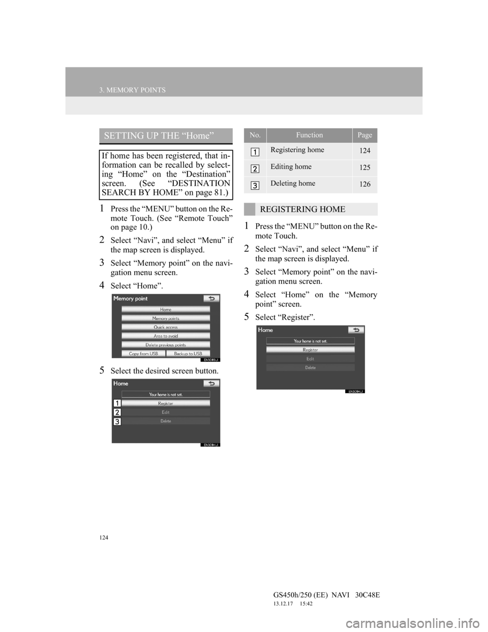
1Press the “MENU” button on the Re-
mote Touch. (See “Remote Touch”
on page 10.)
2Select “Navi”, and select “Menu” if
the map screen is displayed.
3Select “Memory point” on the navi-
gation menu screen.
4Select “Home”.
5Select the desired screen button.
1Press the “MENU” button on the Re-
mote Touch.
2Select “Navi”, and select “Menu” if
the map screen is displayed.
3Select “Memory point” on the navi-
gation menu screen.
4Select “Home” on the “Memory
point” screen.
5Select “Register”.
SETTING UP THE “Home”
If home has been registered, that in-
formation can be recalled by select-
ing “Home” on the “Destination”
screen. (See “DESTINATION
SEARCH BY HOME” on page 81.)
No.FunctionPage
Registering home124
Editing home125
Deleting home126
REGISTERING HOME