info MAZDA MODEL 6 2011 Navigation Manual (in English)
[x] Cancel search | Manufacturer: MAZDA, Model Year: 2011, Model line: MODEL 6, Model: MAZDA MODEL 6 2011Pages: 140, PDF Size: 1.75 MB
Page 24 of 140
![MAZDA MODEL 6 2011 Navigation Manual (in English) 24
RoutingAddress
Book
Getting started
Navigation Setup
This function replaces all the settings in the mobile navigation system with the initial default
settings.
[Default List]
Restore System Defau MAZDA MODEL 6 2011 Navigation Manual (in English) 24
RoutingAddress
Book
Getting started
Navigation Setup
This function replaces all the settings in the mobile navigation system with the initial default
settings.
[Default List]
Restore System Defau](/img/28/13564/w960_13564-23.png)
24
RoutingAddress
Book
Getting started
Navigation Setup
This function replaces all the settings in the mobile navigation system with the initial default
settings.
[Default List]
Restore System Defaults
Before Steps
select
select
MENU
Open the [SYSTEM DEFAULTS] screen
Select .
All of your stored setting data will be deleted.
ItemInitial condition
USER SETTINGS
Map Color 1
Distance Miles
Average Speed (Residential) 25 MPH
Average Speed (Main street) 35 MPH
Average Speed (Freeway) 55 MPH
Road Restriction Warnings On
Arrival Time Time
Keyboard Layout ABC
QUICK POI SELECTION
Quick POI Selection A : Gas Station
B : ATM
C : Police Station
D : Grocery Store
E : All Restaurants
F : Hotel
LANGUAGE
Language English
MAP CONFIGURATION
Map Screen Single map
Tu r n G u i d a n c e Tu r n L i s t
Intersection Detail On
Freeway Information Off
SET CLOCK
Auto Time Zone On
Daylight Saving Time Off
Display Type 12H
Clock on Navi screen OnItemInitial condition
ROUTE PREFERENCES
Toll roads Avoid
Freeway Prefer
Ferries Avoid
Restricted roads Avoid
Border Crossing Prefer
Page 25 of 140
25
Getting started
Screen Names and Functions
Note
lPerform the Navigation Setup before switching the Freeway Information screen on/off.
( page 21)
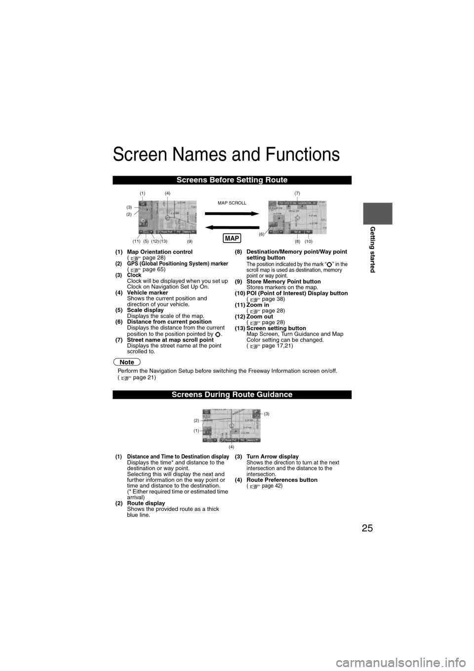
Screens Before Setting Route
(1) Map Orientation control
( page 28)
(2) GPS (Global Positioning System) marker( page 65)(3) ClockClock will be displayed when you set up
Clock on Navigation Set Up On.
(4) Vehicle marker Shows the current position and
direction of your vehicle.
(5) Scale display
Displays the scale of the map.
(6) Distance from current position Displays the distance from the current
position to the position pointed by .
(7) Street name at map scroll point Displays the street name at the point
scrolled to. (8) Destination/Memory point/Way point
setting button
The position indicated by the mark “ ” in the
scroll map is used as destination, memory
point or way point.
(9) Store Memory Point buttonStores markers on the map.
(10) POI (Point of Interest) Display button ( page 38)
(11) Zoom in ( page 28)
(12) Zoom out ( page 28)
(13) Screen setting button Map Screen, Turn Guidance and Map
Color setting can be changed.
( page 17,21)
Screens During Route Guidance
(1) Distance and Time to Destination displayDisplays the time* and distance to the
destination or way point.
Selecting this will display the next and
further information on the way point or
time and distance to the destination.
(* Either required time or estimated time
arrival)
(2) Route display Shows the provided route as a thick
blue line. (3) Turn Arrow displayShows the direction to turn at the next
intersection and the distance to the
intersection.
(4) Route Preferences button( page 42)
(4)
(3)(1)(7)
(8) (10)
(9)(5)(11)(12) MAP SCROLL(6)(13)
(2)MAP
(4) (3)
(1)
(2)
Page 30 of 140
30
Before
UseGetting
started
Routing
Destination Entry and Route Search
l
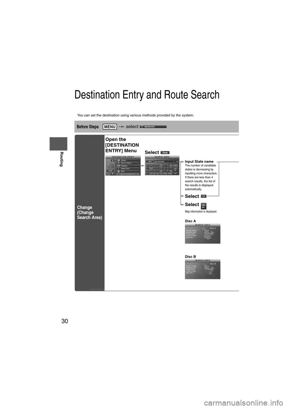
You can set the destination using various methods provided by the system.
Before Steps select
Change
(Change
Search Area)
MENU
Open the
[DESTINATION
ENTRY] Menu
Select
Select the des
ALABAMA
ARIZONA
ARKANSAS
CALIFORNIA
COLORADO
CONNECTICU
TDELAWARE
FLORIDA
GEORGIA
IDAHO
ILLINOIS
INDIANA
IOWA
KANSAS
KENTUCKY
LOUISIANA
MAINE
MARYLAND
MASSACHUSE
TMICHIGAN
MINNESOTA
MISSISSIPPI
MISSOURI
Select
Select
Map information is displayed.
Disc A
Disc B
The information
Input State nameThe number of candidate
states is decreasing by
inputting more characters.
If there are less than 4
search results, the list of
the results is displayed
automatically.
Page 31 of 140
31
Before
UseGetting
started
Routing
lFor Character Entry, please refer to page 39.
lDo not keep your eyes fixed on the monitor screen or operate the system while driving.Do not change the settings and destination locations while driving. Minimize the time spent
viewing the monitor screen and listening to the voice guidance while driving. Operating the system
will distract the driver from looking ahead of the vehicle and may cause an accident. Always stop
the vehicle in a safe location before operating the system.
lRoute searches with the navigation system can include roads that you cannot drive on and roads that you
are prohibited from driving on due to traffic regulations. Please comply with the traffic regulations.
Warnings
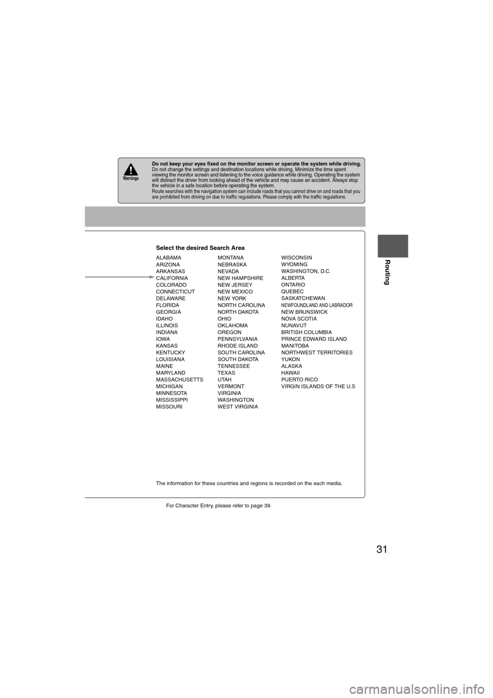
Select the desired Search Area
ALABAMA
ARIZONA
ARKANSAS
CALIFORNIA
COLORADO
CONNECTICUT
DELAWARE
FLORIDA
GEORGIA
IDAHO
ILLINOIS
INDIANA
IOWA
KANSAS
KENTUCKY
LOUISIANA
MAINE
MARYLAND
MASSACHUSETTS
MICHIGAN
MINNESOTA
MISSISSIPPI
MISSOURI MONTANA
NEBRASKA
NEVADA
NEW HAMPSHIRE
NEW JERSEY
NEW MEXICO
NEW YORK
NORTH CAROLINA
NORTH DAKOTA
OHIO
OKLAHOMA
OREGON
PENNSYLVANIA
RHODE ISLAND
SOUTH CAROLINA
SOUTH DAKOTA
TENNESSEE
TEXAS
UTAH
VERMONT
VIRGINIA
WASHINGTON
WEST VIRGINIA WISCONSIN
WYOMING
WASHINGTON, D.C.
ALBERTA
ONTARIO
QUEBEC
SASKATCHEWAN
NEWFOUNDLAND AND LABRADORNEW BRUNSWICK
NOVA SCOTIA
NUNAVUT
BRITISH COLUMBIA
PRINCE EDWARD ISLAND
MANITOBA
NORTHWEST TERRITORIES
YUKON
ALASKA
HAWAII
PUERTO RICO
VIRGIN ISLANDS OF THE U.S
Select
Select
Map information is displayed.
Disc A
Disc B
The information for these countries and regions is recorded on the each media.
Input State nameThe number of candidate
states is decreasing by
inputting more characters.
If there are less than 4
search results, the list of
the results is displayed
automatically.
Page 38 of 140
38
Before
UseGetting
started
Routing
Quick POI
l
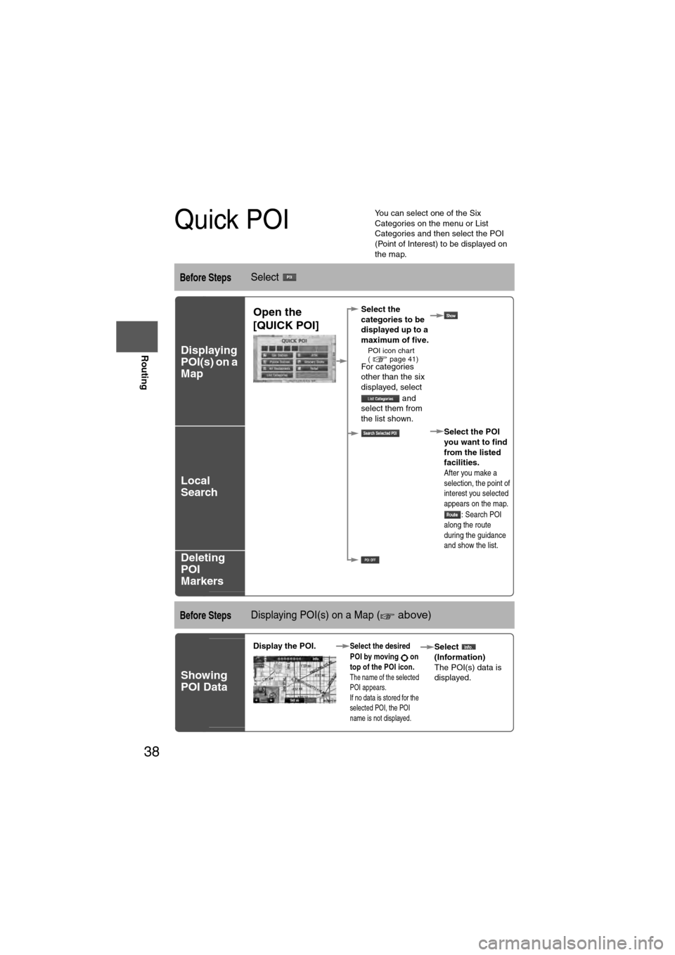
You can select one of the Six
Categories on the menu or List
Categories and then select the POI
(Point of Interest) to be displayed on
the map.
Before StepsSelect
Displaying
POI(s) on a
Map
Local
Search
Deleting
POI
Markers
Before StepsDisplaying POI(s) on a Map ( above)
Showing
POI Data
Open the
[QUICK POI]Select the
categories to be
displayed up to a
maximum of five.
l
POI icon chart
( page 41)
For categories
other than the six
displayed, select
and
select them from
the list shown.
Select the POI
you want to find
from the listed
facilities.
After you make a
selection, the point of
interest you selected
appears on the map.: Search POI
along the route
during the guidance
and show the list.
Display the POI. Select the desired
POI by moving on
top of the POI icon.
The name of the selected
POI appears.
If no data is stored for the
selected POI, the POI
name is not displayed.
Select
(Information)
The POI(s) data is
displayed.
Page 40 of 140
40
Before
UseGetting
started
Routing
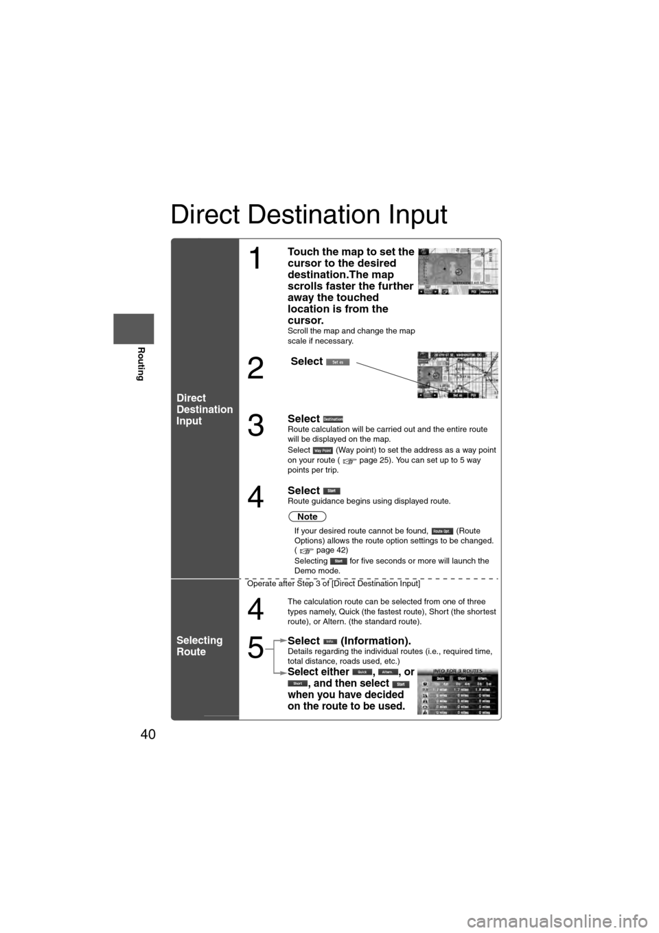
Direct Destination Input
Direct
Destination
Input
Selecting
Route
1
Touch the map to set the
cursor to the desired
destination.The map
scrolls faster the further
away the touched
location is from the
cursor.
Scroll the map and change the map
scale if necessary.
2
Select
3
Select Route calculation will be carried out and the entire route
will be displayed on the map.
Select (Way point) to set the address as a way point
on your route ( page 25). You can set up to 5 way
points per trip.
4
Select Route guidance begins using displayed route.
Note
l
If your desired route cannot be found, (Route
Options) allows the route option settings to be changed.
( page 42)
l Selecting for five seconds or more will launch the
Demo mode.
Operate after Step 3 of [Direct Destination Input]
4
The calculation route can be selected from one of three
types namely, Quick (the fastest route), Short (the shortest
route), or Altern. (the standard route).
5
Select (Information).Details regarding the individual routes (i.e., required time,
total distance, roads used, etc.)
Select either , , or , and then select
when you have decided
on the route to be used.
Page 41 of 140
41
Before
UseGetting
started
Routing
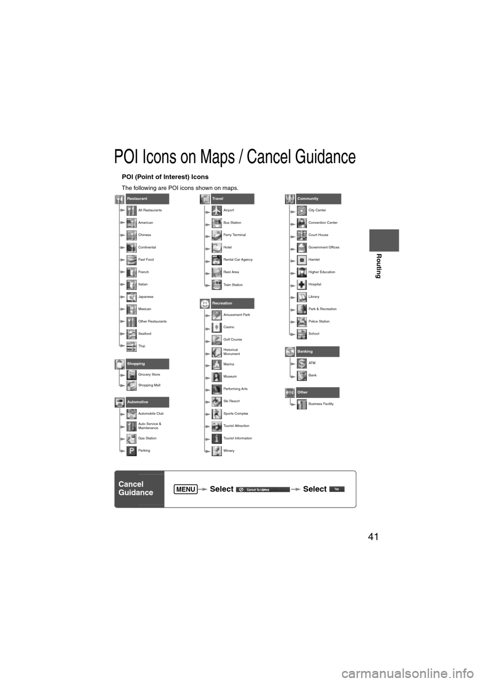
POI Icons on Maps / Cancel Guidance
nPOI (Point of Interest) Icons
The following are POI icons shown on maps.
Restaurant
All Restaurants
American
Chinese
Continental
Fa st Foo d
Fr e nc h
Italian
Japanese
Mexican
Other Restaurants
Seafood
Thai
Shopping
Grocery Store
Shopping Mall
Automotive
Automobile Club
Auto Service &
Maintenance
Gas Station
Par king
Travel
Airport
Bus Station
Ferry Terminal
Hotel
Rental Car Agency
Rest Area
Train Station
Recreation
Amusement Park
Casino
Golf Course
Historical
Monument
Marina
Museum
Performing Arts
Ski Resort
Sports Complex
Tourist Attraction
Tourist Information
Winery
Community
City Center
Convention Center
Court House
Government Offices
Hamlet
Higher Education
Hospital
Library
Park & Recreation
Police Station
School
Banking
AT M
Bank
Other
Business Facility
Cancel
Guidance Select
Select MENU
Page 55 of 140
55
Before
UseGetting
started
Routing Address
Book
Voice Recognition
Avoiding Voice Recognition Errors.Read the notes listed below to allow the Voice Recognition function to recognize your voice properly.l
Speak a voice command clearly.
l Keep yourself in a safe driving position. Do not face or approach the microphone to make a
voice command recognizable.
Voice recognition may fail to recognize your command due to voice tone. If this happens,
change the tone of your voice by speaking more loudly and clearly.
l Keep the inside of the vehicle quiet when making a voice command. Your command may be
compromised by noises made by people, blinkers, the horn, vehicle vibration, and noises
from outside the vehicle.
l Use the language you selected in voice recognition.
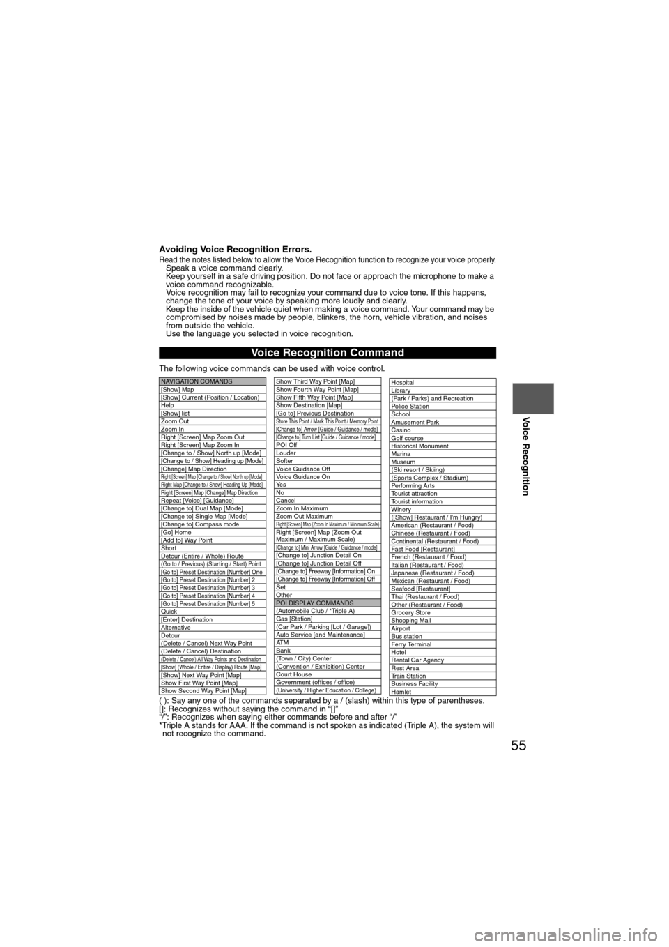
The following voice commands can be used with voice control.
( ): Say any one of the commands separated by a / (slash) within this type of parentheses.
[]: Recognizes without saying the command in “[]”
“/”: Recognizes when saying either commands before and after “/”
*Triple A stands for AAA. If the command is not spoken as indicated (Triple A), the system will not recognize the command.
Voice Recognition Command
NAVIGATION COMANDS
[Show] Map
[Show] Current (Position / Location)
Help
[Show] list
Zoom Out
Zoom In
Right [Screen] Map Zoom Out
Right [Screen] Map Zoom In
[Change to / Show] North up [Mode]
[Change to / Show] Heading up [Mode][Change] Map DirectionRight [Screen] Map [Change to / Show] North up [Mode]Right Map [Change to / Show] Heading Up [Mode]Right [Screen] Map [Change] Map DirectionRepeat [Voice] [Guidance]
[Change to] Dual Map [Mode]
[Change to] Single Map [Mode]
[Change to] Compass mode
[Go] Home
[Add to] Way Point
Short
Detour (Entire / Whole) Route
(Go to / Previous) (Star ting / Star t) Point
[Go to] Preset Destination [Number] One
[Go to] Preset Destination [Number] 2
[Go to] Preset Destination [Number] 3
[Go to] Preset Destination [Number] 4
[Go to] Preset Destination [Number] 5
Quick
[Enter] Destination
Alternative
Detour
(Delete / Cancel) Next Way Point
(Delete / Cancel) Destination
(Delete / Cancel) All Way Points and Destination[Show] (Whole / Entire / Display) Route [Map][Show] Next Way Point [Map]
Show First Way Point [Map]
Show Second Way Point [Map]
Show Third Way Point [Map]
Show Fourth Way Point [Map]
Show Fifth Way Point [Map]
Show Destination [Map]
[Go to] Previous Destination
Store This Point / Mark This Point / Memory Point[Change to] Arrow [Guide / Guidance / mode][Change to] Turn List [Guide / Guidance / mode]POI Off
Louder
Softer
Voice Guidance Off
Voice Guidance On
Ye s
No
Cancel
Zoom In Maximum
Zoom Out Maximum
Right [Screen] Map (Zoom In Maximum / Minimum Scale)Right [Screen] Map (Zoom Out
Maximum / Maximum Scale)
[Change to] Mini Arrow [Guide / Guidance / mode][Change to] Junction Detail On
[Change to] Junction Detail Off
[Change to] Freeway [Information] On
[Change to] Freeway [Information] Off
Set
Other
POI DISPLAY COMMANDS
(Automobile Club / *Triple A)
Gas [Station]
(Car Park / Parking [Lot / Garage])
Auto Service [and Maintenance]
AT M
Bank
(Town / City) Center
(Convention / Exhibition) Center
Court House
Government (offices / office)
(University / Higher Education / College)
Hospital
Library
(Park / Parks) and Recreation
Po l ic e S t a t io n
School
Amusement Park
Casino
Golf course
Historical Monument
Marina
Museum
(Ski resort / Skiing)
(Sports Complex / Stadium)
Performing Arts
Tourist attraction
Tourist information
Winery
([Show] Restaurant / I'm Hungry)
American (Restaurant / Food)
Chinese (Restaurant / Food)
Continental (Restaurant / Food)
Fast Food [Restaurant]
French (Restaurant / Food)
Italian (Restaurant / Food)
Japanese (Restaurant / Food)
Mexican (Restaurant / Food)
Seafood [Restaurant]
Thai (Restaurant / Food)
Other (Restaurant / Food)
Grocery Store
Shopping Mall
Airport
Bus station
Ferry Terminal
Hotel
Rental Car Agency
Rest Area
Train Station
Business Facility
Hamlet
Page 56 of 140
![MAZDA MODEL 6 2011 Navigation Manual (in English) 56
Before
UseGetting
started
Routing Address
Book
Voice Recognition
( ): Say any one of the commands separated by a / (slash) within this type of parentheses.
[]: Recognizes without saying the comm MAZDA MODEL 6 2011 Navigation Manual (in English) 56
Before
UseGetting
started
Routing Address
Book
Voice Recognition
( ): Say any one of the commands separated by a / (slash) within this type of parentheses.
[]: Recognizes without saying the comm](/img/28/13564/w960_13564-55.png)
56
Before
UseGetting
started
Routing Address
Book
Voice Recognition
( ): Say any one of the commands separated by a / (slash) within this type of parentheses.
[]: Recognizes without saying the command in “[]”
“/”: Recognizes when saying either commands before and after “/”
*Triple A stands for AAA. If the command is not spoken as indicated (Triple A), the system will
not recognize the command.
NEAREST POI DISPLAY COMMANDSNearest (Automobile Club / *Triple A)
Nearest Gas [Station]
Nearest (Car Park / Parking [Lot / Garage])Nearest Auto Service [and Maintenance]Nearest ATM
Nearest Bank
Nearest (Town Center / City Center)
Nearest (Exhibition / Convention) CenterNearest Court House
Nearest Government offices
Nearest (University / Higher
Education [Institute] / College)
Nearest Hospital
Nearest Library
Nearest (Park / Parks) and
Recreation [Facility]
Nearest Police Station
Nearest School
Nearest Amusement Park
Nearest Casino
Nearest Golf course
Nearest Historical Monument
Nearest Marina
Nearest Museum
Nearest (Ski resort / Skiing facility)
Nearest (Sports Complex / Stadium)
Nearest (Performing Arts [Venue] / Theater)Nearest Tourist attraction
Nearest Tourist information
Nearest Winery
Nearest Restaurant
Nearest American (Restaurant / Food)Nearest Chinese (Restaurant / Food)Nearest Continental (Restaurant / Food)Nearest Fast Food [Restaurant]
Nearest French (Restaurant / Food)
Nearest Italian (Restaurant / Food)
Nearest Japanese (Restaurant / Food)
Nearest Mexican (Restaurant / Food)
Nearest Seafood [Restaurant]
Nearest Thai (Restaurant / Food)
Nearest Other (Restaurant / Food)
Nearest Grocery Store
Nearest Shopping Mall
Nearest Airport
Nearest Bus station
Nearest Ferry Terminal
Nearest Hotel
Nearest Rental Car Agency
Nearest Rest Area
Nearest Train Station
Nearest Business Facility
Nearest Hamlet
AUDIO COMMANDS
radio
AM [radio]
FM [radio]
SIRIUS / Satellite
(Disc / CD / CD changer)
Audio [on / off]
AUX1 / Auxiliar y1
AUX2 / Auxiliar y2
Seek up
Seek down
Type up
Type down
Track up / Next track
Track down
Previous track
Folder up
Folder down
Disc up / Next disc
Disc down / Previous disc
TEL COMMANDS
(Phone / Telephone)
Page 60 of 140
60
Before
UseGetting
started
Routing Address
Book
Voice Recognition
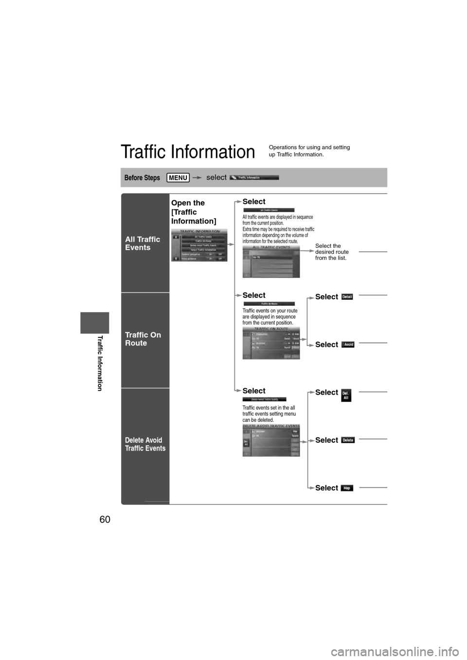
Traffic Information
Traffic Information
l
Operations for using and setting
up Traffic Information.
Before Steps select
All Traffic
Events
Traffic On
Route
Delete Avoid
Traffic Events
MENU
Open the
[Traffic
Information] Select
All traffic events are displayed in sequence
from the current position.
Extra time may be required to receive traffic
information depending on the volume of
information for the selected route.
Select the
desired route
from the list.
Select
Traffic events on your route
are displayed in sequence
from the current position.
Select Detailed information on
traffic events is displayed.
Select A setting for traffic
avoidance is available.
Select
Traffic events set in the all
traffic events setting menu
can be deleted.
Select All set traffic events
can be deleted.
Select Individual traffic eventscan be deleted.
Select The selected traffic eveis displayed on the scr