navigation MERCEDES-BENZ CLS-Class 2010 W164 Comand Manual
[x] Cancel search | Manufacturer: MERCEDES-BENZ, Model Year: 2010, Model line: CLS-Class, Model: MERCEDES-BENZ CLS-Class 2010 W164Pages: 224, PDF Size: 7 MB
Page 42 of 224
XPress : or 9 to select the
appropriate time zone.XTo switch between Daylight Saving and
Standard Time: Select Daylight
Saving Time (Summer) or Standard
Time (Winter).
The R dot indicates the current setting.XTo save setting and exit menu:
Press = or ; .
Language Setting
This function allows you to determine the
language for the menu displays and the
navigation messages. The language selection
affects the input options in the editing and
smart speller.
XSelect System £Settings £Language .
The language list appears. The R dot
indicates the current setting.XTo change setting: Press : or 9 to
select the desired language.XTo confirm the language selection:
Press 9.
COMAND loads the selected language and
sets it.
Display Settings
Adjusting Brightness
XSelect System £ Settings £ Display
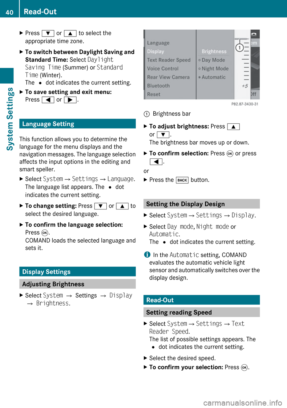
£ Brightness .1Brightness barXTo adjust brightness: Press 9
or : .
The brightness bar moves up or down.XTo confirm selection: Press 9 or press
= .
or
XPress the k button.
Setting the Display Design
XSelect System £Settings £Display .XSelect Day mode , Night mode or
Automatic .
The R dot indicates the current setting.
i
In the Automatic setting, COMAND
evaluates the automatic vehicle light
sensor and automatically switches over the
display design.
Read-Out
Setting reading Speed
XSelect System £Settings £Text
Reader Speed .
The list of possible settings appears. The
R dot indicates the current setting.XSelect the desired speed.XTo confirm your selection: Press 9.40Read-OutSystem Settings
Page 47 of 224
External Authorization
If COMAND cannot find your mobile phone,
this may be due to special security settings
on your mobile phone. In this case, you can
check whether, conversely, your mobile
phone can find COMAND.
COMAND's Bluetooth device name is “MB
Bluetooth”.XSelect System £Settings
£ Bluetooth £Bluetooth Device
List £Options £External
Authorization .XStart Bluetooth search procedure on the
mobile phone ( Y mobile phone operating
guide).XSelect COMAND (“MB Bluetooth”) from the
device list on your mobile phone.XWhen prompted to do so, enter the
passcode on the mobile phone and on
COMAND.
De-authorizing a Bluetooth Device
XOpen the Bluetooth device list
( Y page 43).XSelect the authorized device.XSelect Options £De-authorize .
You will be asked whether the device
should really be de-authorized.XSelect Yes or No.
If you select Yes, the authorization of the
device is withdrawn.
Reset
i You can fully reset COMAND to the
factory settings. This process deletes all
personal data, among other things, (e.g.
station memory, address book entries,
entries in the destination memory and in
the last destinations of the navigation
system). It is recommended that you
perform a reset before the vehicle is
handed over or sold, for example.XSelect System £Settings £Reset .
You will be prompted to confirm that you
wish to perform the reset.XSelect Yes or No.
If you select Yes, you will again be
prompted to confirm that you wish to
perform the reset.XSelect Yes or No.
If you select Yes, COMAND is reset and
restarted.Reset45System SettingsZ
Page 49 of 224
Introduction ......................................... 48
Destination Input ................................ 61
POI Input .............................................. 73
Route Guidance ................................... 80
Traffic Messages ................................. 87
Destination Memory ...........................90
Last Destinations ................................ 9347Navigation
Page 50 of 224
Introduction
Vehicle Equipment
i This Operator’s Manual describes all
features, standard or optional, potentially
available for your vehicle at the time of
purchase. Please be aware that your
vehicle might not be equipped with all
features described in this manual.
Safety Instructions
GWarning
For safety reasons, only enter a destination
when the vehicle is stationary. When the
vehicle is in motion, a passenger should enter
the destination. Study manual and select
route before driving.
Bear in mind that at a speed of just 30 mph
(approximately 50 km/h), your vehicle is
covering a distance of 44 feet (approximately
14 m) every second.
COMAND calculates the route to the
destination without taking account of the
following:
R Traffic lights
R Stop and right-of-way-signs
R Lane merging
R Parking or stopping prohibited areas
R Other road and traffic rules and regulations
R Narrow bridges
GWarning
COMAND may give incorrect navigation
commands if the data in the digital map does
not correspond with the actual road/traffic
situation. Digital maps do not cover all areas
nor all routes within an area. For example, if
the traffic routing has been changed or the
direction of a one-way road has been
reversed.
For this reason, you must always observe
applicable road and traffic rules and
regulations during your journey. Road and
traffic rules and regulations always have
priority over the navigation commands
generated by the system.GWarning
Navigation announcements are intended to
direct you while driving without diverting your
attention from the road and driving.
Please always use this feature instead of
consulting the map display for directions.
Consulting the symbols or map display for
directions may cause you to divert your
attention from driving and increase your risk
of an accident.
Updating the Map Software
The digital data for the map software will
become obsolete, just like conventional road
maps. Optimum route guidance by the
navigation system is only achieved with up-
to-date map software. Information on new
map software versions is available from an
authorized Mercedes-Benz Center.
You can have the map software updated there
by means of a DVD or perform the update
process yourself.
Notes on DVD Discs
R Only touch the discs at the edges.
R Handle the discs with care in order to
prevent reading errors.
R Avoid scratching, leaving fingerprints and
dust on the discs.
R Use a commercially available cleaning cloth
to clean discs. Always wipe in a straight line
from the inside outwards, never in a circular
motion.
R After use, put the discs back into the box.
R Protect the discs from heat and direct
sunlight.
48IntroductionNavigation
Page 51 of 224
Update Sequence
The sequence includes the following stages:
R Loading DVD into the DVD changer
R Update process
i The update process may take between 60
and 150 minutes, depending on the size of
the map software.
If possible, perform the update when the
vehicle is stationary. The DVD read speed
is faster when the vehicle is stationary than
when the vehicle is moving and the update
therefore takes less time. If you perform
the update with the engine off and the
vehicle battery is no longer powerful
enough, COMAND may shut off
automatically during the process to protect
the battery. In this case, restart the update
with the engine running.
You can interrupt the update process and
continue it at later time. If you cancel the
update process, the navigation system is
not ready for operation.
GWarning
Never leave the engine running in an enclosed
space. The exhaust gases contain carbon
monoxide. Inhaling exhaust gases constitutes
a health hazard and could lead to loss of
consciousness or even death.
Loading DVDs into DVD Changer
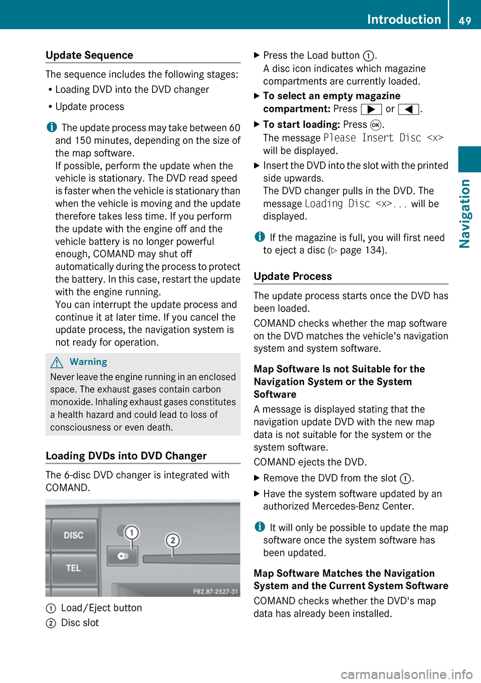
The 6-disc DVD changer is integrated with
COMAND.
1Load/Eject button2Disc slotXPress the Load button 1.
A disc icon indicates which magazine
compartments are currently loaded.XTo select an empty magazine
compartment: Press ; or = .XTo start loading: Press 9.
The message Please Insert Disc
will be displayed.XInsert the DVD into the slot with the printed
side upwards.
The DVD changer pulls in the DVD. The
message Loading Disc
displayed.
i If the magazine is full, you will first need
to eject a disc ( Y page 134).
Update Process
The update process starts once the DVD has
been loaded.
COMAND checks whether the map software
on the DVD matches the vehicle's navigation
system and system software.
Map Software Is not Suitable for the
Navigation System or the System
Software
A message is displayed stating that the
navigation update DVD with the new map
data is not suitable for the system or the
system software.
COMAND ejects the DVD.
XRemove the DVD from the slot 1.XHave the system software updated by an
authorized Mercedes-Benz Center.
i It will only be possible to update the map
software once the system software has
been updated.
Map Software Matches the Navigation
System and the Current System Software
COMAND checks whether the DVD's map
data has already been installed.
Introduction49NavigationZ
Page 52 of 224
Map Data Is Already Installed
The version release and a corresponding
message will be given on the display.XTo confirm message: Press 9.
COMAND ejects the DVD.
Map Data Is not yet Installed
The version release and a query as to whether
the update should be carried out will be given
on the display.
XSelect Yes or No.
If No is selected, COMAND ejects the DVD
automatically and the map data is not
updated.XRemove the DVD from the slot.
If Yes is selected, the map data is updated.
Updating the Map Data
While the update is in progress, a
corresponding message and a progress bar
are displayed. The progress bar fills from left
to right over the course of the update. The
navigation system is not functional until the
update is complete.
You cannot eject the DVD during the update.
If you switch COMAND off during the update,
this will interrupt the update and the update
will resume at the point of interruption when
the system is restarted.
While updating, COMAND may prompt you to
change the DVD. A corresponding message
is then displayed.
XPress the Eject button V.
The magazine menu appears. The magazine
compartment containing the current disc is
highlighted.XPress 9.
COMAND ejects the DVD.XRemove the DVD from the slot.XInsert the DVD requested by COMAND.
If the update has been completed
successfully, a corresponding message is
displayed.XTo confirm message: Press 9.
COMAND ejects the DVD.XRemove the DVD from the slot.
The update is complete.
If the update has not been completed
successfully, a message is displayed
indicating that the map update is not
possible.
XTo confirm message: Press 9.
COMAND ejects the DVD.XRemove the DVD from the slot.
An unseccussful update may be caused by
one of the following:
R DVD dirty or scratched.
XClean the DVD.
Please refer to the “Notes on DVD
discs” section ( Y page 48).XRestart the update.
R
Overheating as a result of excessively high
temperatures in the passenger
compartment.
XWait until the passenger compartment
has cooled down.XRestart the update.
General Information
Operational Readiness of the
Navigation System after the System
Software Update
Sometimes the installed map software is no
longer compatible following a system
software update by an authorized Mercedes-
Benz Center. In this case, the navigation
system is not operational.
XTo update map software: Proceed as
described in the “Update Process” section
( Y page 49). Use map software compatible
with the system software.
i Please note that in this case the update
must run through right to the end. If you
50IntroductionNavigation
Page 53 of 224
cancel beforehand, the navigation system
will still not be ready for operation.
After start-up or initial start-up, the navigation
system must perform a position finding
operation. As a result, you may have to drive
for some time until precise route guidance
takes place.
GPS Reception
The correct functioning of the navigation
system is also dependent on the GPS
reception. In certain situations, the GPS
reception may be impaired, distorted or even
impossible, e.g. in tunnels, multi-storey car
parks or due to snow on the GPS antenna. If
there is snow on the GPS antenna, you should
remove it. The GPS antenna is at the rear on
the vehicle's roof.
Route Guidance after Vehicles
Transport
After vehicle transport (e.g. by ferry, car train
or by towing) COMAND must determine the
vehicle location again.
Position finding takes place automatically
when the vehicle is driven off again, even if
COMAND is switched off. The actual length of
time may vary from case to case.
While the vehicle is determining its position,
route guidance is subject to the following
restrictions:
R Navigation announcements, route
guidance displays and displayed street
names do not match the actual location.
R COMAND does not issue any navigation
announcements.
R The message Off Mapped Road and a
direction arrow are displayed instead of the
route guidance displays. The arrow
indicates the direction of the destination.
i Direction arrow accuracy is also
dependent on correct vehicle position
and/or direction.
Once the position finding operation has been
completed, route guidance takes place again
via navigation announcements and route
guidance displays.
Interrupting Journey during Route
Guidance
i An interruption in the journey means
parking the vehicle and switching off
COMAND.
The continuation of the journey means
switching COMAND on again and
continuing to drive.
If interrupt the journey during route guidance
and continue it later, the following applies:
R If you continue the journey within 2 hours,
COMAND automatically continues route
guidance.
R If you continue the journey after 2 hours,
route guidance is cancelled. You will have
to continue the cancelled route guidance
again manually ( Y page 85).
Measurement Units
The measurement units displayed in
navigation mode are identical to those set in
the instrument cluster.
Input Restriction
There is an input restriction for vehicles for
certain countries.
The restriction is active for vehicle speeds
above approx. 3 mph. The restriction is
deactivated as soon as the speed falls below
approx. 2 mph.
Certain entries cannot be made when the
restriction is active, e.g. a city or road entry.
This is indicated by the fact that certain menu
items cannot be selected.
Introduction51NavigationZ
Page 54 of 224
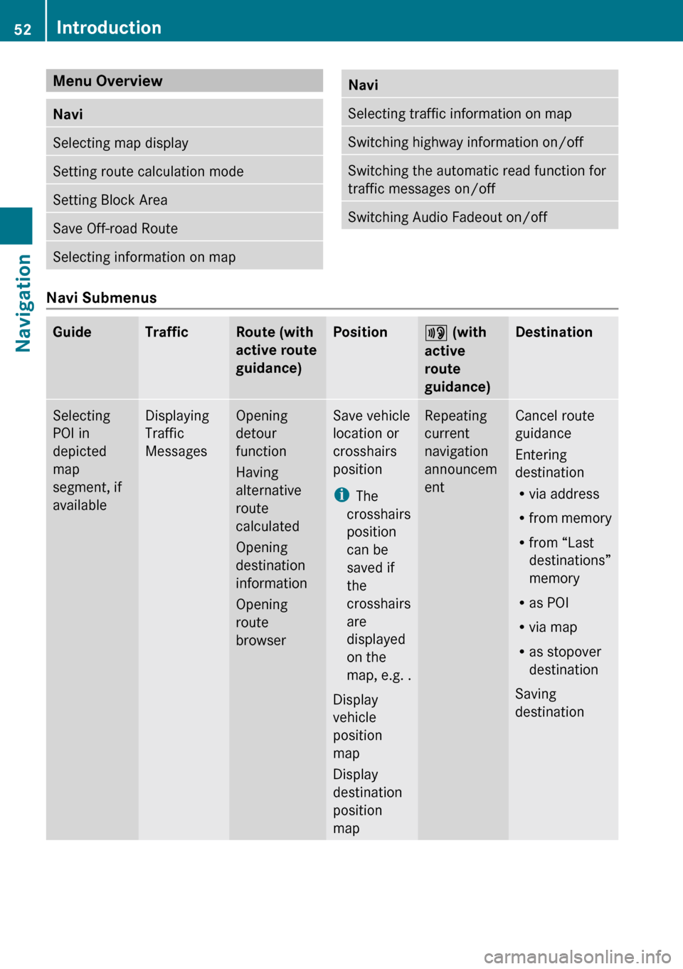
Menu Overview NaviSelecting map displaySetting route calculation modeSetting Block AreaSave Off-road RouteSelecting information on mapNaviSelecting traffic information on mapSwitching highway information on/offSwitching the automatic read function for
traffic messages on/offSwitching Audio Fadeout on/off
Navi Submenus
GuideTrafficRoute (with
active route
guidance)Position6 (with
active
route
guidance)DestinationSelecting
POI in
depicted
map
segment, if
availableDisplaying
Traffic
MessagesOpening
detour
function
Having
alternative
route
calculated
Opening
destination
information
Opening
route
browserSave vehicle
location or
crosshairs
position
i The
crosshairs
position
can be
saved if
the
crosshairs
are
displayed
on the
map, e.g. .
Display
vehicle
position
map
Display
destination
position
mapRepeating
current
navigation
announcem
entCancel route
guidance
Entering
destination
R via address
R from memory
R from “Last
destinations”
memory
R as POI
R via map
R as stopover
destination
Saving
destination52IntroductionNavigation
Page 55 of 224
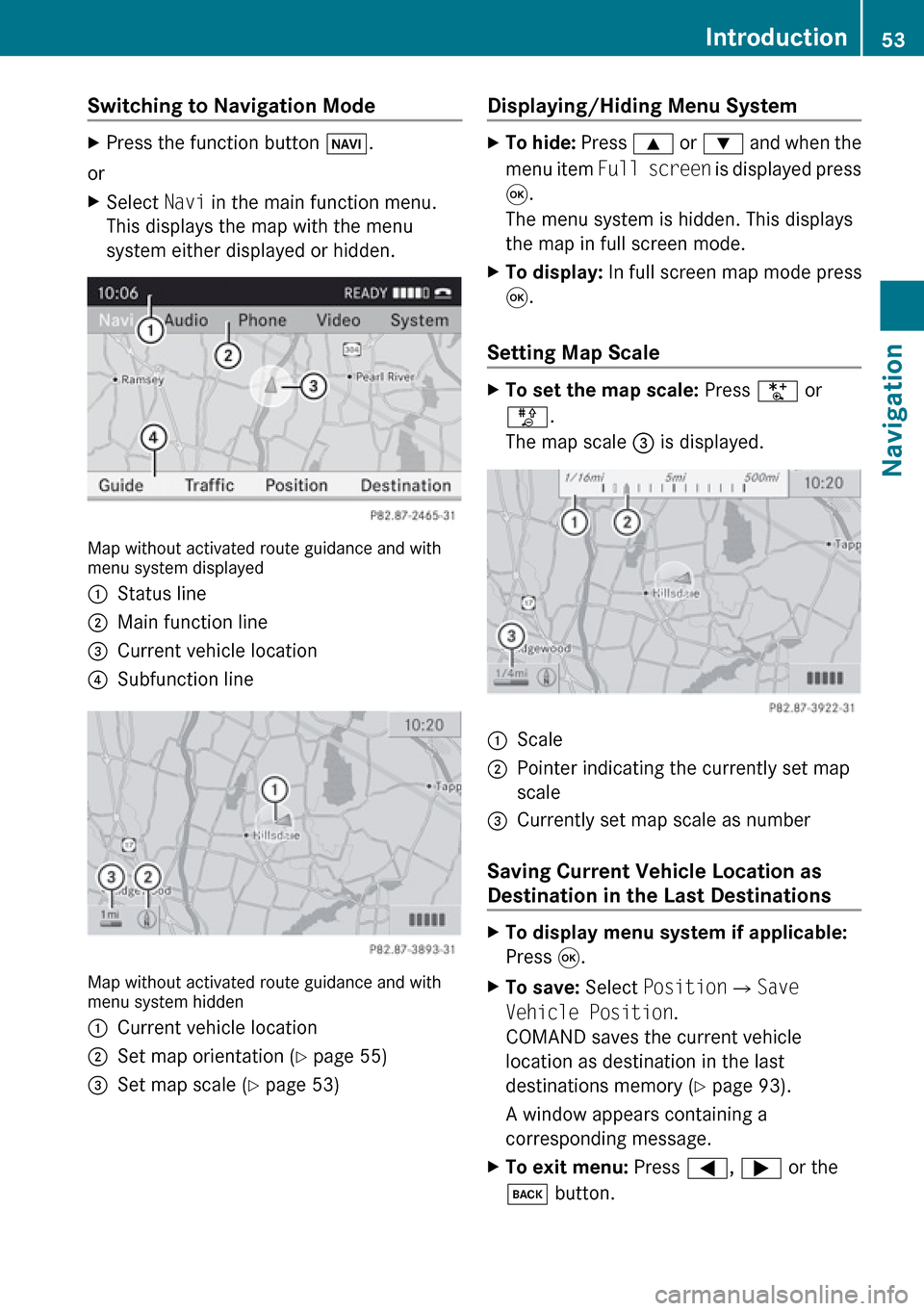
Switching to Navigation Mode XPress the function button Ø.
or
XSelect Navi in the main function menu.
This displays the map with the menu
system either displayed or hidden.
Map without activated route guidance and with
menu system displayed
1Status line2Main function line3Current vehicle location4Subfunction line
Map without activated route guidance and with
menu system hidden
1Current vehicle location2Set map orientation ( Y page 55)3Set map scale ( Y page 53)Displaying/Hiding Menu System XTo hide: Press 9 or : and when the
menu item Full screen is displayed press
9 .
The menu system is hidden. This displays
the map in full screen mode.XTo display: In full screen map mode press
9 .
Setting Map Scale
XTo set the map scale: Press U or
T .
The map scale 3 is displayed.1Scale2Pointer indicating the currently set map
scale3Currently set map scale as number
Saving Current Vehicle Location as
Destination in the Last Destinations
XTo display menu system if applicable:
Press 9.XTo save: Select Position £Save
Vehicle Position .
COMAND saves the current vehicle
location as destination in the last
destinations memory ( Y page 93).
A window appears containing a
corresponding message.XTo exit menu: Press =, ; or the
k button.Introduction53NavigationZ
Page 56 of 224
Scrolling the Map
iYou can only scroll the map when the
menu system is hidden (map in full-screen
mode).
XHide menu system if applicable
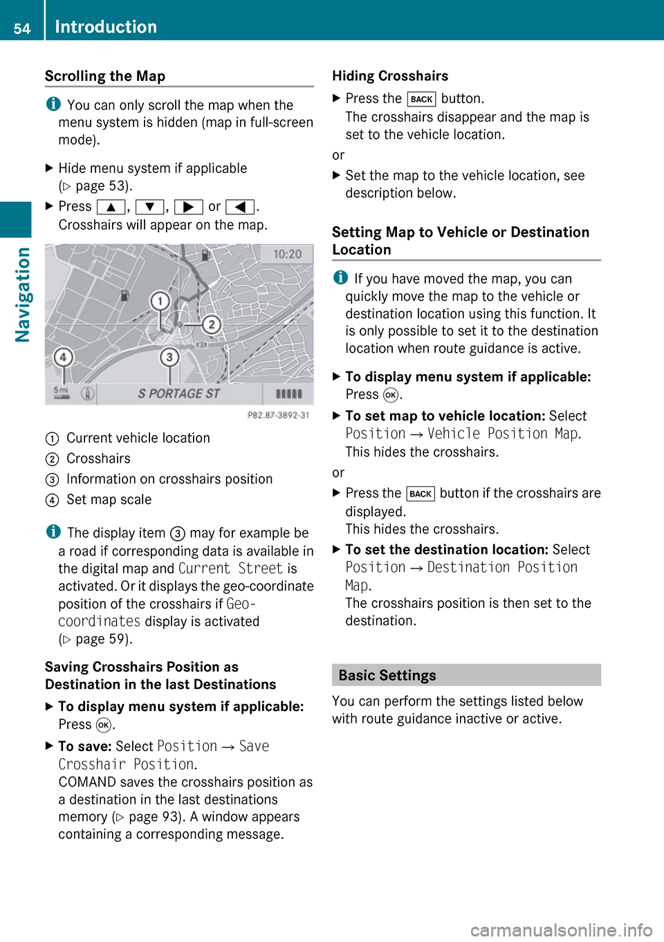
( Y page 53).XPress 9, : , ; or = .
Crosshairs will appear on the map.1Current vehicle location2Crosshairs3Information on crosshairs position4Set map scale
i The display item 3 may for example be
a road if corresponding data is available in
the digital map and Current Street is
activated. Or it displays the geo-coordinate
position of the crosshairs if Geo-
coordinates display is activated
( Y page 59).
Saving Crosshairs Position as
Destination in the last Destinations
XTo display menu system if applicable:
Press 9.XTo save: Select Position £Save
Crosshair Position .
COMAND saves the crosshairs position as
a destination in the last destinations
memory ( Y page 93). A window appears
containing a corresponding message.Hiding Crosshairs XPress the k button.
The crosshairs disappear and the map is
set to the vehicle location.
or
XSet the map to the vehicle location, see
description below.
Setting Map to Vehicle or Destination
Location
i If you have moved the map, you can
quickly move the map to the vehicle or
destination location using this function. It
is only possible to set it to the destination
location when route guidance is active.
XTo display menu system if applicable:
Press 9.XTo set map to vehicle location: Select
Position £Vehicle Position Map .
This hides the crosshairs.
or
XPress the k button if the crosshairs are
displayed.
This hides the crosshairs.XTo set the destination location: Select
Position £Destination Position
Map .
The crosshairs position is then set to the
destination.
Basic Settings
You can perform the settings listed below
with route guidance inactive or active.
54IntroductionNavigation