vehicle not in position p MERCEDES-BENZ M-Class 2012 W166 Comand Manual
[x] Cancel search | Manufacturer: MERCEDES-BENZ, Model Year: 2012, Model line: M-Class, Model: MERCEDES-BENZ M-Class 2012 W166Pages: 234, PDF Size: 6.74 MB
Page 104 of 234
Map
information inthe display During
routeguidance, youcan have map
informati onshow natthe bottom edgeofthe
displa y.
Showing textinformat ion
X To show themenu: pressWthe COMAND
cont roller.
X Select Navi in
the main functionbar by
sliding ZVandturning cVdtheCOMAND
cont roller andpress Wtoconfirm .
X Select MapSettings and
press Wto
confirm .
The map settin gsmenu appears.
X Select TextInformation OnMap and
press Wtoconfirm .
A # dot indicates thecurrent setting. X
Select Arrival Time/Distance ,
Current Street ,
Geo-coordinates or
None and
press Wtoconfirm .
X To exit themenu: slideXVY theCOMAND
cont roller.
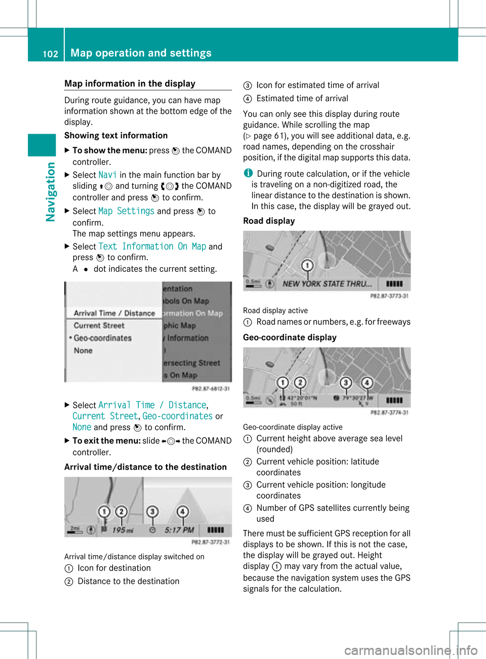
Arrival time/distance tothe destination Arrival
time/distanc edisplay switched on
: Icon fordestination
; Distanc eto the destination =
Icon forestimated timeofarrival
? Estimated timeofarrival
You canonly seethis displa yduring route
guida nce.While scrolling themap
(Y page 61),youwillsee additional data,e.g.
road names, depending onthe crosshair
position, ifthe digital mapsupports thisdata.
i During routecalculation, orifthe vehicle
is traveling onanon- digitized road,the
linear distance tothe destination isshown.
In this case, thedispla ywill begrayed out.
Road display Road
display active
: Road names ornumbers, e.g.forfreeways
Geo-coo rdinatedisplay Geo-coordinate
displayactive
: Current heightaboveaverage sealevel
(rounded)
; Current vehicleposition: latitude
coordinates
= Current vehicleposition: longitude
coordinates
? Number ofGPS satellites currentlybeing
used
There mustbesufficient GPSreception forall
displa ystobe shown. Ifthis isnot thecase,
the displa ywill begrayed out.Height
displa y: may varyfrom theactual value,
because thenavigation systemusestheGPS
signals forthe calculation. 102
Map
operat ionand settingsNavigat ion
Page 105 of 234
While
scrollin gthe map (Ypage 61),youwill
see thegeo-c oordinat esofthe cross hair
position .Height display :and number of
satellites used?are not displayed.
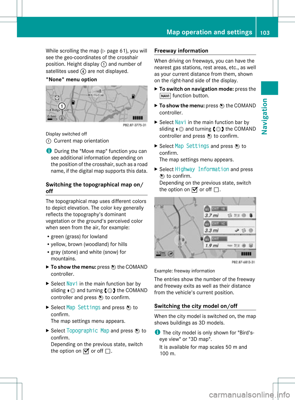
"None" menuoption Display
switchedoff
: Current maporient ation
i Durin gthe "Move map"function youcan
see additional information depending on
the position ofthe cross hair,such asaroad
name, ifthe digital mapsupports thisdata.
Switching thetopogr aphical map on/
off The
topogr aphical mapuses differen tcolors
to depict elevation. Thecolor keygenerally
reflect sthe topography's dominant
vegetation orthe ground's perceived color
when seenfromtheair,forexample:
R green (grass) forlowland
R yellow ,brown (woodland) forhills
R gray (stone) andwhite (snow) for
mountains.
X To show themenu: pressWthe COMAND
cont roller.
X Select Navi in
the main functionbar by
sliding ZVandturnin gcVd theCOMAND
cont roller andpress Wtoconf irm.
X Select MapSettings and
press Wto
conf irm.
The map settings menu appears.
X Select Topographic Map and
press Wto
conf irm.
Dependin gon the previous state,switch
the option onO oroff ª. Freeway
information When
driving onfreeways, youcan have the
nearest gasstation s,rest areas, etc.,as well
as your current distance fromthem, shown
on the right- hand sideofthe display .
X To switch onnavigation mode:pressthe
Ø functionbutton .
X To show themenu: pressWthe COMAND
cont roller.
X Select Navi in
the main functionbar by
sliding ZVandturnin gcVd theCOMAND
cont roller andpress Wtoconf irm.
X Select MapSettings and
press Wto
conf irm.
The map settings menu appears.
X Select Highway Information and
press
W toconf irm.
Dependin gon the previous state,switch
the option onO oroff ª. Example:
freewayinformation
The entriesshow thenumber ofthe freeway
and freeway exitsaswell astheir distance
from thevehicle's currentposition.
Switching thecity model on/off When
thecity model isswitched on,the map
shows buildingsas3D models.
i The citymodel isonly shown for"Bird's-
eye view" or"3D map".
It is availa bleformap scales 50ma nd
100 m. Map
operatio nand settin gs
103Navi gation Z
Page 110 of 234
X
Sel ect SIRIUS Service and
pressW to
confi rm.
The window onthe right halfof the displ ay
sho wsthe telephone numb erofthe
pro vider(SIR IUSXM) andtheserialnumb er
of your ser vice module for rece iving traf fic
mes sages .
Reg isteri ngfor the SIRIU SXM traffic
repo rtse rvic e X
Ca llthe trafficrep ort provider'spho ne
numb ersho wnonthe scre en.
i Youcan also have the satel lite ser vice
acti vate donl ine.Todo so, visit theSIRIUS
XM Radio website at
htt <0010002C00210021001700170017002000130009001200090015001300200003
000F000DH (USA)or
htt <0010002C00210021001700170017002000130009001200090015001300030001
000E000100040001H .com
(Canada) .
Once theconn ection hasbeen established:
X Follow theinstr uctions ofthe operator.
The activation processmaytake uptoten
minutes.
If registrat ionisnot included when
purchasing thesystem, yourcredit card
details willberequired toactivate your
account . Compass
function
In the compass view,youcan seethecurrent
direction oftravel, thecurrent heightabove
sea level andthecoordinat esofthe vehicle
position, forexample.
X To switch onnavigation mode:pressthe
Ø functionbutton .
X To show themenu: pressWthe COMAND
cont roller.
X Select Pos. in
the navigation systemmenu
bar bysliding VÆandturnin gcVd the
COMAND controller andpress Wto
conf irm.
X Select Compass and
press Wtoconf irm. Compass
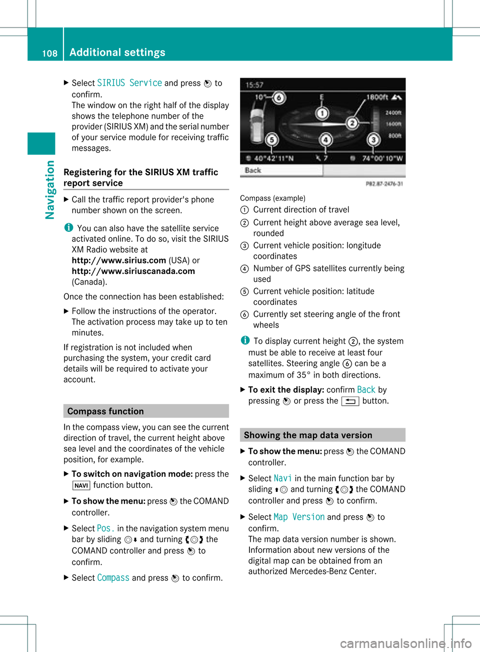
(example)
: Current direction oftravel
; Current heightaboveaverage sealevel,
rounded
= Current vehicleposition: longitude
coordinat es
? Number ofGPS satellites currentlybeing
used
A Current vehicleposition: latitude
coordinat es
B Currently setsteerin gangle ofthe front
wheels
i Todisplay current height;,thesystem
must beable toreceive atleast four
satellites. Steeringangle Bcan bea
maximum of35° inboth direction s.
X To exit thedisplay: confirmBack by
pressing Worpress the% button . Showing
themap dataversion
X To show themenu: pressWthe COMAND
cont roller.
X Select Navi in
the main functionbar by
sliding ZVandturnin gcVd theCOMAND
cont roller andpress Wtoconf irm.
X Select MapVersion and
press Wto
conf irm.
The map data version number isshown.
Infor mation aboutnewversions ofthe
digital mapcanbeobtained froman
authorized Mercedes-B enzCenter. 108
Additional
settingsNavigation
Page 146 of 234

COMAN
Dfea tures
Thes eOper atingIn st ruc tions desc ribeall
st andar dand optionalequipm enta vail able
for you rCOMAND systematthe time of
purcha se.Cou ntry-specifi cdeviation sare
possible. Pleasenotethat your COMAND
system maynotbeequipped withallthe
features described. Rad
iomode General
information
i Portable electronicdevices inthe vehicle
may seriously impairradiorecept ion. Switching
torad iomode
Opt ion 1 X
Press $thefunc tion button .
The radio display appears. Youwillhear the
last stationplayed onthe last waveband.
i Repeatedly pressingthisfunc tion button
switch esbetween theFM, AMand WB
wavebands inthat order andthen calls up
SatRadio mode.Pressin gthe button again
takes youback toFM radio mode.
Opt ion 2 X
Select Audio in
the main function barby
sliding ZVandturningcVd theCOMAND
con troller andpress Wtocon firm.
If radio mode wasthelast mode selected,
it will now beactive.
If anoth eraudio mode isswitch edon, you
can now switch toradio mode inthe audio
menu.
X Select Audio by
sliding ZVtheCOMAND
con troller andpress Wtocon firm.
The audio menu appears. Ex
ample: audiomenu
: Current audiooperatin gmode
; Main function bar
= Audio menu
X Select FM/AM Radio by
turn ingcVd the
COMAND controller andpress Wto
con firm. Ex
ample: HDRadio display
: Display window withstationsett ings
; Preset position ofthe select edstat ion
= Name ofthe select edstat ion(icon forHD
Radio™ andnumber ofsubprogram)
? Frequenc yof the select edstat ion
A Sound settings
B FM radio, AMradio orWB radio
C Program information
D Preset functions
E Radio functions 144
Rad
iomod eAudio
Page 188 of 234
COMAN
Dfea tures
Thes eOper atingIn st ruc tions desc ribeall
st andar dand optionalequipm enta vail able
for you rCOMAND systematthe time of
purcha se.Cou ntry-specifi cdeviation sare
possible. Pleasenotethat your COMAND
system maynotbeequipped withallthe
features described. General
information Autom
aticpictu reshut off
The video image isonly displayed ifthe
select orlever ofthe tran smission isin
position P.
If the select orlever ofthe tran smission is
changed fromposition P,the In order not
to
distrac tyou from thetraffic situati
on, the picture is faded out
while
thevehicle isinmotion. message
appears
As soon asthe select orlever ofthe
tran smission isreturn edtoposition P,the
video image isshown. Basic
settings Pictur
esettings
Adju sting thebright ness,contra stor
color X
Press Wthe COMAND controller toshow
the menu.
X Select DVD-Vid eo by
sliding VÆand
turn ingcVd theCOMAND controller and
press Wtocon firm.
Am enu appears.
X Select Brightn ess ,
Contras t or
Color by
turn ingcVd theCOMAND controller and
press Wtocon firm. Changing
thepictu reform at X
Press Wthe COMAND controller toshow
the menu.
X Select DVD-Vid eo by
sliding VÆand
turn ingcVd theCOMAND controller and
press Wtocon firm.
Am enu appears.
X Select 16:9Optimiz ed ,
4:3 or
Widescr een and
press Wtocon firm.
The dotinfron tof the entryindicat esthe
curren tlyselect edformat .
X Select asett ingbyturn ingcVd the
COMAND controller andpress Wto
con firm. Video
DVDmode Safet
ynotes G
WARN
ING
COMAND isclassified asaClass 1laser
prod uct.You must notopen thecasing. Ifyou
open thecasing, orifthe casing isfaulty or
damaged, thereisarisk ofexposure to
invisible laserradiation. Thismay damage
your eyes, orthose ofothers.
COMAND doesnotcont ainany parts thatcan
be serviced bythe user. Forsafety reasons,
all mainten ancework must becarried outby
quali fiedaftersales technicians. G
WARNING
Only when thevehicle isstation aryshould
you:
R load adisc
R eject adisc
There isarisk ofbeing distract edfrom the
road andtraffic conditionsifthis isdone while
the vehicle isin motion . 186
Video
DVDmodeVideo
Page 198 of 234
COMAN
Dfea tures
Thes eOper atingIn st ruc tions desc ribeall
st andar dand optionalequipm enta vail able
for you rCOMAND systematthe time of
purcha se.Cou ntry-specifi cdeviation sare
possible. Pleasenotethat your COMAND
system maynotbeequipped withallthe
features described. SIRIUS
Weather Introd
uction
For therecept ionofweather forecastsvia
satellite radio,youwillneed aSIRIUS XM
Satellit eWeather subscript ion.
When theCall SIRIUS toactivat e system at 888-539
-7474 message
withthe
SIRIUS deviceidentification number appears,
you willfirst have toobtain access tothe
weather service.Ad escript ionofthe
procedure canbefound inthe "Registering
satellite radio"section(Ypage 149).
COMAND canreceive weather forecastsvia
satellite radioforthe entireUSA (including
Alaska andHawaii). Thereceived weather
data canbedisplayed asan infor mation chart
(daily forecast,five-dayforec ast,detail
infor mation )or on the weather map.
The weather datareceived fromaweather
stat ionisstor edinCOMAND foranhour and
can beshown againimmediately after
rest artin gthe engin e(e.g. after refueling).
The weather mapcandisplay thefollowing
weather datawithsymbols:
R rain radar
R stor mcharact eristics
R areas ofhigh-pres sure/low-pr essure,
weather fronts
R course oftropic alcyclon es(hurricanes ,
typhoon s)
R wind direct ionand speeds
i The rain radar cannotbe displayed for
Alaska, HawaiiandPuerto Rico. i
Hurric ane:descript ionofatropic al
cyclon ewhich mostlydevelop inthe
At lantic Ocean orinthe Nort hPacific
Ocean orSouth Pacific Ocean. Thewind
speeds areabove 74mph (118 km/h).To
charact erizethestrengt hof ahurrican e,
ther eare five categor ies.
Typhoon: thedescript ionofatropic al
cyclon ethat develops inthe Nort hWest
Pacific Ocean. Thewind speeds areinthe
categor yof ahurrican e. Switching
theSIRIUS weather display
on/off
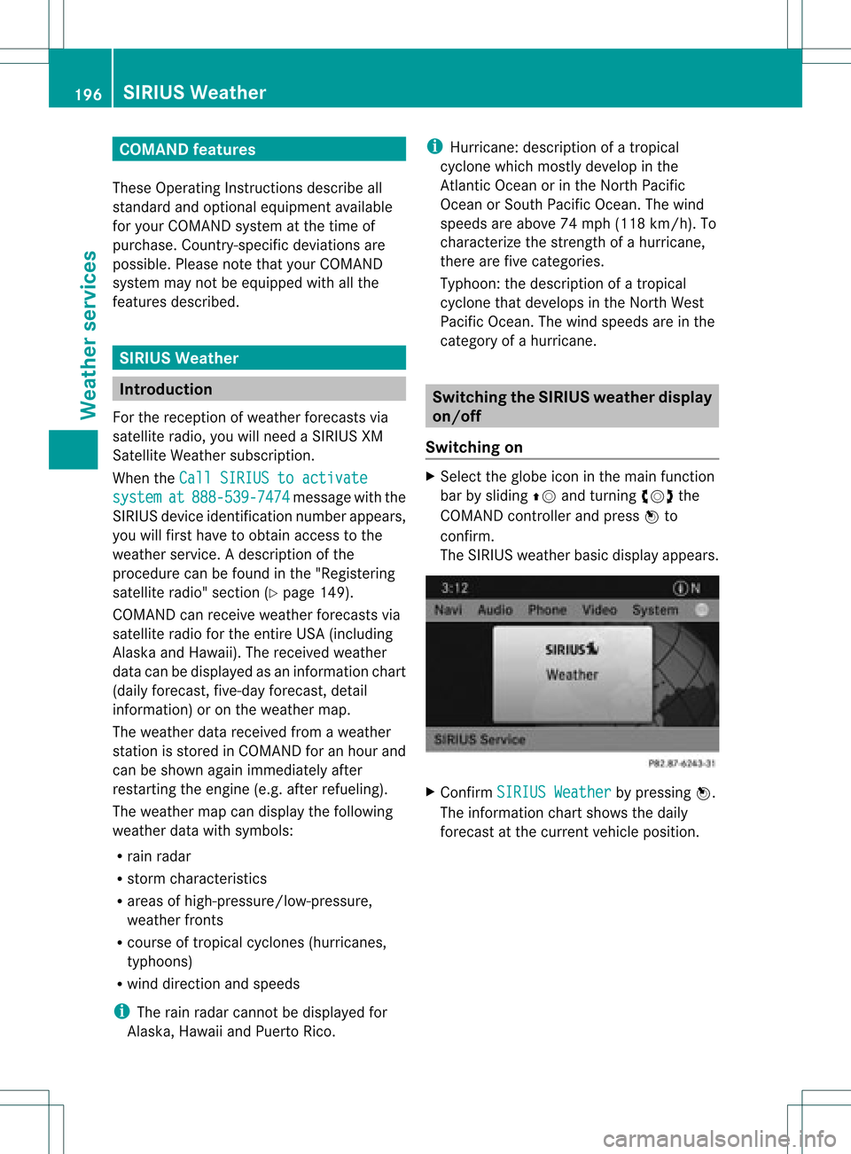
Switching on X
Select theglobe iconinthe main function
bar bysliding ZVandturningcVd the
COMAND controller andpress Wto
con firm.
The SIRIUS weather basicdisplay appears. X
Confirm SIRIUS Weather by
pressing W.
The infor mation chartshows thedaily
forec astatthe curren tvehicle position . 196
SIRIUS
WeatherWeat herservices
Page 200 of 234

alread
ysave dareas inthemem ory
(Y page 199).
i COMA NDreceive sweat herforecas tdata
fr om thene ares tweat herstatio nat the
selec teddest ination.
Opt ion 1:select ingthelocat ioninthe
infor mation chart X
Sel ect Position in
theinf orm ationch art
by turnin gcVd theCOMA NDcontroll er
and pres sW toconfirm .
Am enu appears. "Select
ingthe area forthe weather forecast"menu
X To select thecurr entvehicle position:
select Current Position and
press Wto
con firm.
COMAND receivestheweather dataforthe
curren tvehicle position fromthenearest
weather stationand displays it
automatic ally.
X To select thevicinity ofthe
destina tion:select NearDestina tion in
the menu byturn ingcVd theCOMAND
con troller andpress Wtocon firm.
i You canselect NearDestina tion if
a
route hasbeen calculated (Ypage 57).The
menu itemisother wisegrayed out.
X To select winter sportareas:select In Winter
SportsAreas in
the menu, and
con firm bypressing W. X
Select astat e,e.g. Colorad o ,
and press
W tocon firm.
X Select awinter sportsarea from themenu
and press Wtocon firm.
The weather dataandother information is
displayed forthe winter sportsarea that
has been select ed.The data issupplied by
the nearest weather station.
The infor mation chartshows thefollowing
infor mation (ifavailable):
R ski slopes/sk ilifts
R snowboardin gand night time openin g
R snow conditions (e.g.snow depth)
R temper ature X
To select thevicinity ofanoth er
location: selectSearch Locatio
ns in
the
menu byturn ingcVd theCOMAND
con troller andpress Wtocon firm. 198
SIRIUS
WeatherWeat herservices