navigation system MERCEDES-BENZ R-Class 2011 W251 Comand Manual
[x] Cancel search | Manufacturer: MERCEDES-BENZ, Model Year: 2011, Model line: R-Class, Model: MERCEDES-BENZ R-Class 2011 W251Pages: 214, PDF Size: 4.69 MB
Page 85 of 214
Map
display
Setting themap orientation Map
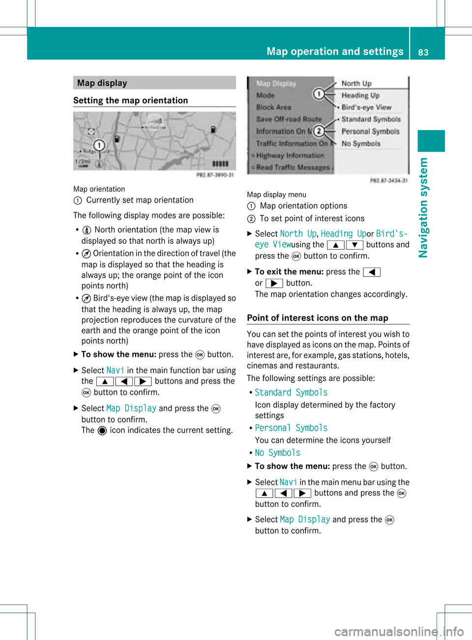
orientati on
: Currently setmap orientati on
The followi ngdisp laymodes arepossi ble:
R 0 North orientati on(the map view is
disp layed sothat north isalw aysup)
R ¤ Orientati oninthe dire ction oftravel (the
map isdisp layed sothat theheading is
alw aysup; the orange pointofthe icon
poi nts north)
R ¤ Bird's-e yeview (themap isdisp layed so
that theheading isalw aysup, the map
projection reproducesthecurvatu reofthe
earth andtheorange pointofthe icon
poi nts north)
X To show themenu: pressthe9button.
X Select Navi in
the mainfunction barusing
the 9=; buttonsandpress the
9 button toconfirm.
X Select MapDisplay and
press the9
button toconfirm.
The äicon indica testhe current setting. Map
displaymenu
: Map orientati onoptions
; Toset pointofinterest icons
X Select North Up ,
Heading Up or
Bird's- eye View usi
ng the 9: buttonsand
press the9button toconfirm.
X To exitthe menu: pressthe=
or ; button.
The map orientati onchanges accordingly.
Poi ntofintere stico nson the map You
cansetthe points ofinterest youwishto
have displayed asicons onthe map. Points of
interest are,forexampl e,gas stations, hotels,
cinemas andrestau rants.
The followi ngsettings arepossi ble:
R Standar dSymbols Icon
displaydetermi nedbythe factory
settings
R Persona lSymbols You
candetermi nethe icons yourself
R No Symbols X
To show themenu: pressthe9button.
X Select Navi in
the mainmenu barusing the
9=; buttonsand press the9
button tocon firm.
X Select MapDisplay and
press the9
button tocon firm. Map
opera tionandsettings
83Navigation system Z
Page 86 of 214
X
Sel ect StandardSymbols ,
Per sonal Sym
bols or
No Sym bols .
If yo usel ect Per sonal Sym
bols ,
the list of
poi nts ofinter estappe ars .
X To switchthe ico ndisplay on/off:select
the pointofinterest using the 9:
buttons andpress the9button toconfirm.
Dependi ngon the previ oussetting, the
icons willbe swi tched onO oroff ª.Y ou
can switch onthe icon display sfor more
than onepoint ofinter est.
i The listshows allicons thatarecont ained
on the digital mapacross allcount ries.
However, notallpoints ofinter estare
availa bleinall count ries.Asaresult, certain
point ofinter esticons maynotbedisplay ed
on the map, evenifthe icon display is
switched on.
X To exit themenu: pressthe=
or ; button . Map
informa tioninthe display
Displaying mapinforma tion During
routeguidance, youcan have map
inform ationdisplay edatthe bottom edgeof
the display .
X To show themenu: pressthe9button .
X Select Navi in
the main menu barusing the
9=; buttonsand press the9
button toconf irm.
X Select Information On Map and
press the
9 button toconf irm.
The äicon indicates thecurrent setting.
X Select Arrival Time/Distance ,
Current Street ,
Geo-coordina tes or
None and
press the9button toconf irm.
X To exit themenu: pressthe=
or ; button . Arrival
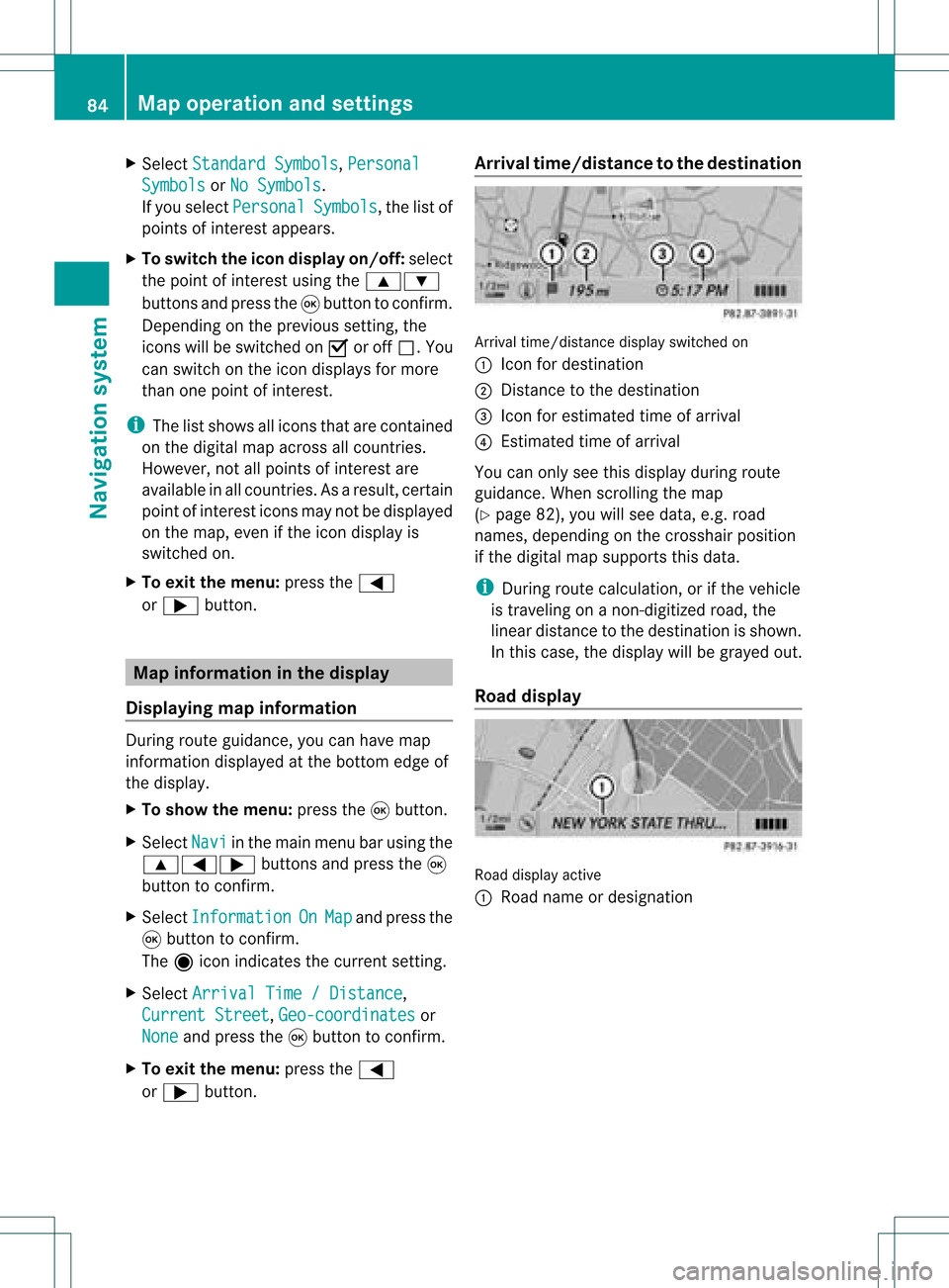
time/dist ancetothe destinat ion Arrival
time/dist ancedisplay switched on
: Icon fordestination
; Distan cetothe destination
= Icon forestimated timeofarrival
? Estimated timeofarrival
You canonly seethis display duringroute
guidance. Whenscrolling themap
(Y page 82),youwillsee data, e.g.road
names, depending onthe crosshair position
if the digital mapsupports thisdata.
i During routecalculation, orifthe vehicle
is traveling onanon- digitized road,the
linear distance tothe destination isshown.
In this case, thedisplay willbegrayed out.
Road display Road
display active
: Road name ordesignation 84
Map
operat ionand settingsNavigation system
Page 87 of 214
Geo-c
oordinate display Geo-coord
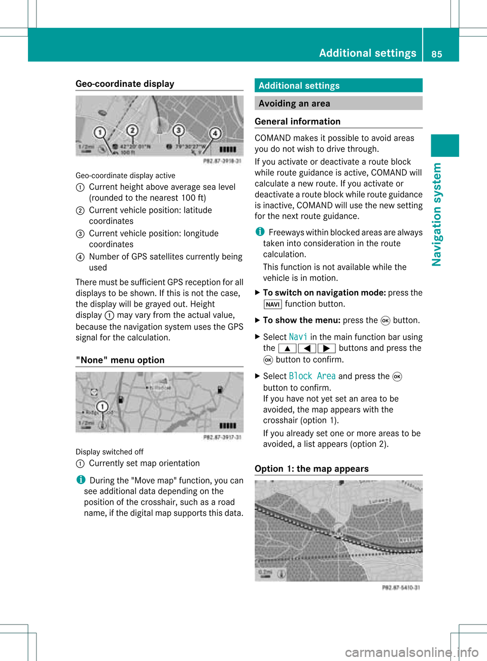
inatedisplayactive
: Current heightabo veavera gesea level
(rou nded tothe nearest 100ft)
; Current vehicle position: latitude
coordina tes
= Current vehicle position: longitu de
coordina tes
? Numbe rofG PS satellites currentlybeing
used
There mustbesufficient GPSrecept ionforall
displays tobe shown. Ifthis isnot thecase,
the display willbegrayed out.Height
display :may varyfrom theactual value,
because thenavigation systemusestheGPS
signal forthe calculation.
"None" menuoption Display
switched off
: Currently setmap orient ation
i During the"Move map"function,youcan
see additional datadepending onthe
position ofthe crosshair, suchasaroad
name, ifthe digital mapsupports thisdata. Additional
settings Avoiding
anarea
General information COMAND
makesitpossible toavoid areas
you donot wish todrive through.
If you activat eor deactivat earoute block
while route guidance isactive, COMAND will
calculate anew route. Ifyou activat eor
deactivat earoute block whileroute guidance
is inact ive,COMAND willuse thenew setting
for the next route guidance.
i Freeways withinblocked areasarealway s
taken intocons ideration inthe route
calculation.
This funct ionisnot availabl ewhile the
vehicle isin motion .
X To switch onnavigation mode:pressthe
Ø functionbutton .
X To show themenu: pressthe9button .
X Select Navi in
the main functionbar using
the 9=; buttonsand press the
9 button toconf irm.
X Select Block Area and
press the9
button toconf irm.
If you have notyetsetanarea tobe
avoided, themap appears withthe
crosshair (option1).
If you already setone ormore areas tobe
avoided, alist appears (option2).
Option 1:the map appears Addit
ional settings
85Navigation system Z
Page 88 of 214
X
To scrol lthe map: pressthe =;
9: buttons.
X To setthe map scale :pre ssthe U or
T button.
The scaleba ra ppears.
X Press theU orT buttonagain.
The map view iszoom edinor out.
X To add anarea tobe avoided :press the
9 butt on.
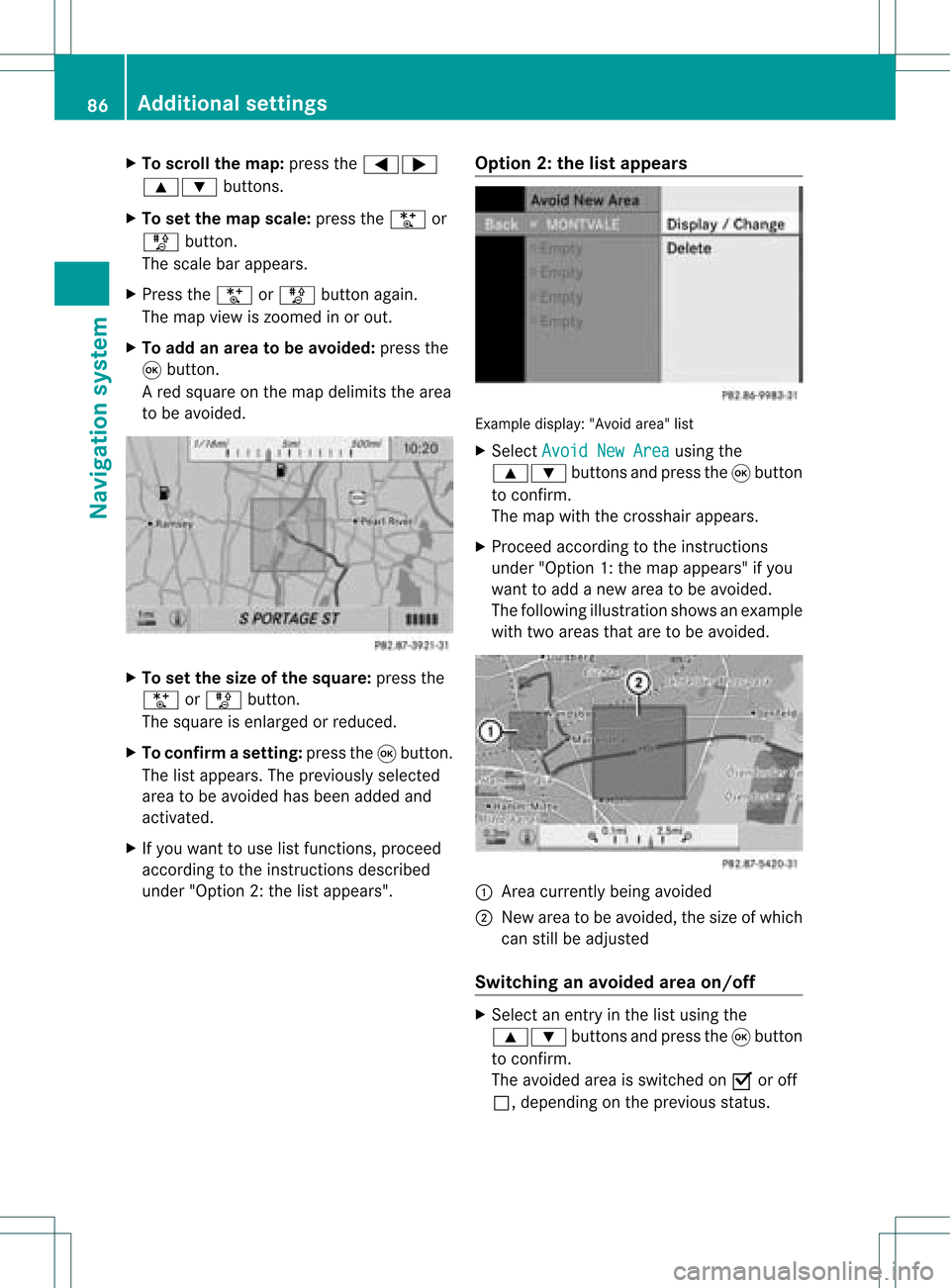
Ar ed square onthe map delimits thearea
to be avoided. X
To set the size ofthe squa re:press the
U orT button .
The square isenlarged orreduced.
X To confirm asett ing: pressth e9 butt on.
The listappears .The previously selected
area tobe avoided hasbeen added and
activated.
X Ifyou want touse listfunct ions, proceed
according tothe instruct ionsdescribed
under "Option 2:the listappea rs". Option
2:the listappears Example
display:"Avoi dare a"list
X Sel ect AvoidNew Area us
ing the
9: buttons andpressthe 9button
to confi rm.
The map with the cros shairap pe ars .
X Pro cee dacco rding tothe instr uctions
und er"Opti on 1:the map appe ars "if yo u
wa ntto addanew areato be avo ided .
The followi ng illu stra tions hows anexample
with twoareas thataretobe avoided. :
Area current lybeing avoided
; New areatobe avoided, thesize ofwhich
can stillbeadjusted
Switching anavoided areaon/o ff X
Select anentr yin the listusing the
9: buttonsandpress the9button
to confirm .
The avoided areaisswitched onO oroff
ª, depending onthe previous status. 86
Additional
settingsNavigationsystem
Page 89 of 214
Disp
laying andc hangi nganavoi ded
area X
Select anentry inthe listusi ng the
9: buttons.
X Select Option s usi
ng the ; button and
press the9button toconfirm.
X Select Displa y/Change and
press the
9 button toconfirm.
The area tobe avoi ded isindi cated inthe
map.
X To chang ethe posi tion ofthe area: press
the =;9 or; button.
The area ismoved onthe map.
X To chang ethe size ofthe area: press the
U orT button.
The area isenla rged orredu ced.
X To confirm thechang e:press the9
button.
The lista ppears andthechang eis ent ered.
Deleting asetarea X
Sele ctan ent ryinthelist usin gth e
9: buttons.
X Sele ctOpt ions usin
gth e; buttonand
pres sth e9 butt ontocon firm.
X Sele ctDel ete and
pres sth e9 butt onto
con firm.
Aq uery appear sask ing whet hertheen try
sho uld bedelet ed.
X Se lec tYes or
No .
If you selectYes ,
th een try is delet ed.
If you selectNo ,
th epro cess will be
can celed. "R
ecor drou te" funct ion
Swit chingth efu nct ion on/of f X
To swit chon nav igationmod e:pre ssthe
Ø function button.
X To show themen u:pre ssthe9 button. X
Se lec tNav i in
themain function bar usin g
th e9=; buttons and pressthe
9 buttonto confirm .
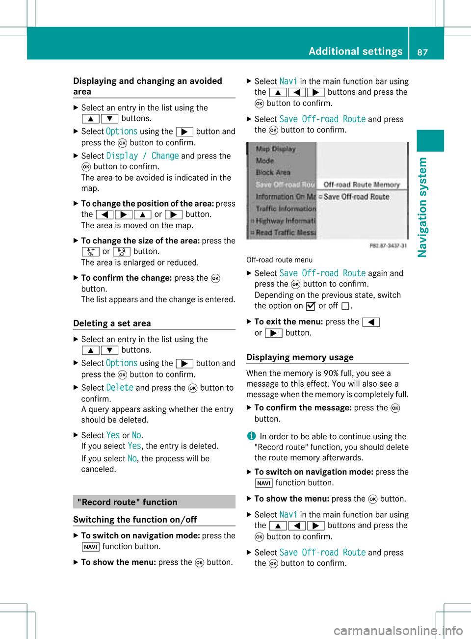
X Se lec tSav eOff -roadRoute and
press
th e9 buttonto confirm . Off
-road routemen u
X Se lec tSav eOff -roadRoute again
and
pre ssthe9 buttonto confirm .
De pen dingon thepre vious state ,swit ch
th eopt ion onO oroff ª.
X To exit themen u:pre ssthe=
or ; button.
Disp laying mem oryusage When
themem oryis90 %full, youseea
mes sage tothis eff ect.You willalso seea
mes sage when themem oryisco mple tely full.
X To confi rmthemes sage:pre ssthe9
but ton.
i Inord erto be able tocontinue usingth e
"Reco rdrout e"fun ction ,you should delete
the route memory afterwards.
X To switch onnavigation mode:pressthe
Ø functionbutton .
X To show themenu: pressthe9button .
X Select Navi in
the main functionbar using
the 9=; buttonsand press the
9 button toconf irm.
X Select SaveOff-road Route and
press
the 9button toconf irm. Additional
settings
87Navigation system Z
Page 91 of 214
Comp
assfunct ion
You canseethecur ren tvehicle position and
direct ionoftravel inthe compass view.
X To switch onnavigat ionmode: pressthe
Ø function button .
X To show themenu: pressthe9button .
X Select Positio n in
the navigation menu
bar using the:=; buttonsand
press the9button tocon firm.
X Select Compass and
press the9button to
con firm.
Depen dingonthe previous state,switch
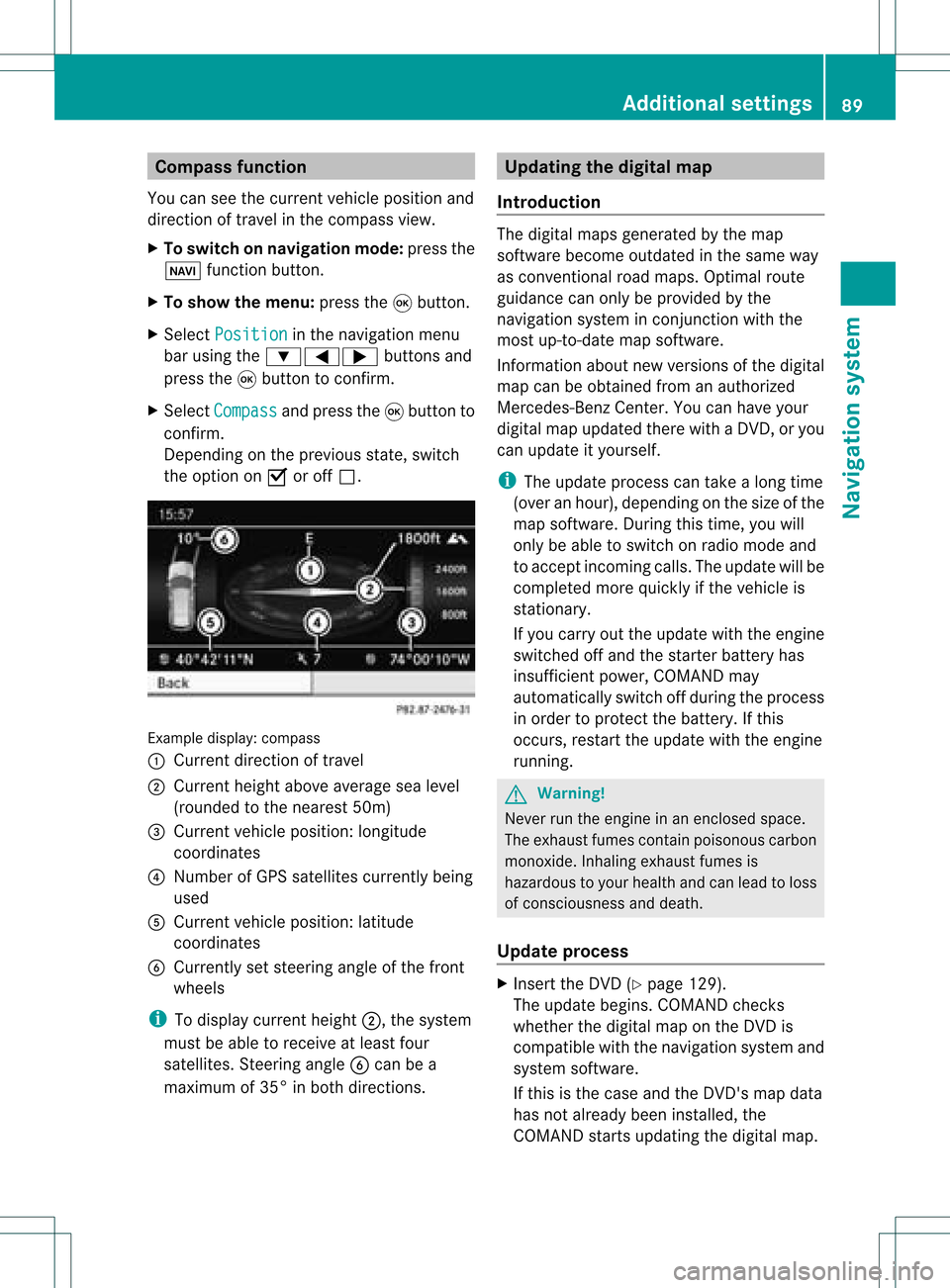
the option onO oroff ª. Ex
ample display: compass
: Current directionoftravel
; Current heightaboveaverage sealevel
(rounded tothe nearest 50m)
= Current vehicleposition :longitude
coordinat es
? Number ofGPS satellites currentlybeing
used
A Current vehicleposition: latitude
coordinat es
B Currently setsteerin gangle ofthe front
wheels
i Todisplay current height;,thesystem
must beable toreceive atleast four
satellites. Steeringangle Bcan bea
maximum of35° inboth direction s. Upda
tingthedigital map
Introdu ction The
digital mapsgenerated bythe map
software becomeoutdated inthe same way
as conv ention alroad maps. Optimal route
guidance canonly beprovided bythe
navigation systeminconj unct ionwith the
most up-to- datemapsoftware.
Infor mation aboutnewversions ofthe digital
map canbeobtained fromanauthorized
Mercedes-B enzCenter. Youcanhave your
digital mapupdated therewithaDVD ,or you
can update ityourself.
i The update process cantake along time
(over anhour), depending onthe size ofthe
map software. Duringthistime, youwill
only beable toswitch onradio mode and
to accept incomin gcalls. Theupdate willbe
completed morequickly ifthe vehicle is
station ary.
If you carry outtheupdate withtheengine
switched offand thestart erbattery has
insufficient power,COMAND may
automatically switchoffduring theprocess
in order toprotec tthe battery. Ifthis
occurs, restarttheupdate withtheengine
runnin g. G
War
ning!
Never runtheengine inan enclosed space.
The exhaust fumescontainpoisonous carbon
monox ide.Inhaling exhaustfumesis
hazardous toyour health andcanlead toloss
of consc iousness anddeath.
Upda teprocess X
Insert theDVD (Ypage 129).
The update begins. COMAND checks
whether thedigital maponthe DVD is
compatible withthenavigation systemand
system software.
If this isthe case andtheDVD 'smap data
has notalready beeninstalled, the
COMAND startsupdating thedigital map. Additional
settings
89Navigation system Z
Page 92 of 214
If
the map data hasalready been install ed,
the disp layshows version dataanda
messag eto this effect.
X To con firm themessage :press the9
button.
X Eject theDVD.
Whil ethe update isrunning, youwillsee a
messag eto this effect andaprogress bar.The
naviga tionsystem isnot opera tional untilthe
upd ate iscomplete.
i You cannot ejecttheDVD duringthe
upd ate. Ifyou switch offCOMAND during
the update, theupdate isinterrupted. It
then continues fromwhere itwas
interrupted whenthesystem isrestarted.
COMAND mayprompt youtochange theDVD
duri ngthe update.
X Press theV load/eject button.
X Take theDVD outofthe slot.
X Insert thereque stedDVD.
Once theupdate has been successfu lly
completed, youwillsee amessag eto this
effect.
X To con firm themessage :press the9
button.
X Take theDVD outofthe slot.
The update iscomplete.
If the upd ateisnot successfu llycompleted,
you willsee amessag ethat themap update
is not possi ble.
X To con firm themessage :press the9
button.
X Take theDVD outofthe slot. 90
Addition
alsettingsNavigation system
Page 93 of 214
Problems
withthenavigation system Problem Possible
causes/co nsequences andM Solutions
COMAND
isunable to
cont inue route
guida nceafter the
journey hasbeen
interr upted. Route
guidanceiscanceled ifyou interr uptthejourney formore
than twohours.
"Interr upting thejourney" referstostopping thevehicle and
switching offCOMAND. "Continuing routeguidance"refers to
switching COMAND backonand driving on.
X Continue routeguidance(Ypage 68).
COMAND determines thevehicle's position.Depending onthe
driving situation, thismay take some time.
Route guidancemay berestric tedduring thedeterminat ionof
the vehicle's position.
When positioning iscomplete, routeguidanceisresumed with
navigation announcementsandroute guidancedisplay s. Problem Possible
causes/co nsequences andM Solutions
COMAND
isunable to
determine thevehicle's
position. COMAND
hastoredetermine theposition ofthe vehicle ifthe
vehicle hasbeen transport ed(e.g. byferry, bymotorail orafter
towing).
X Start thevehicle andpullaway .
COMAND determines thevehicle's position.Depending onthe
driving situation, thismay take some time.
Route guidancemay berestric tedduring thedeterminat ionof
the vehicle's position.
When positioning iscomplete, routeguidanceisresumed with
navigation announcementsandroute guidancedisplay s. Problems
withthenavigation system
91Navigation system Z
Page 94 of 214
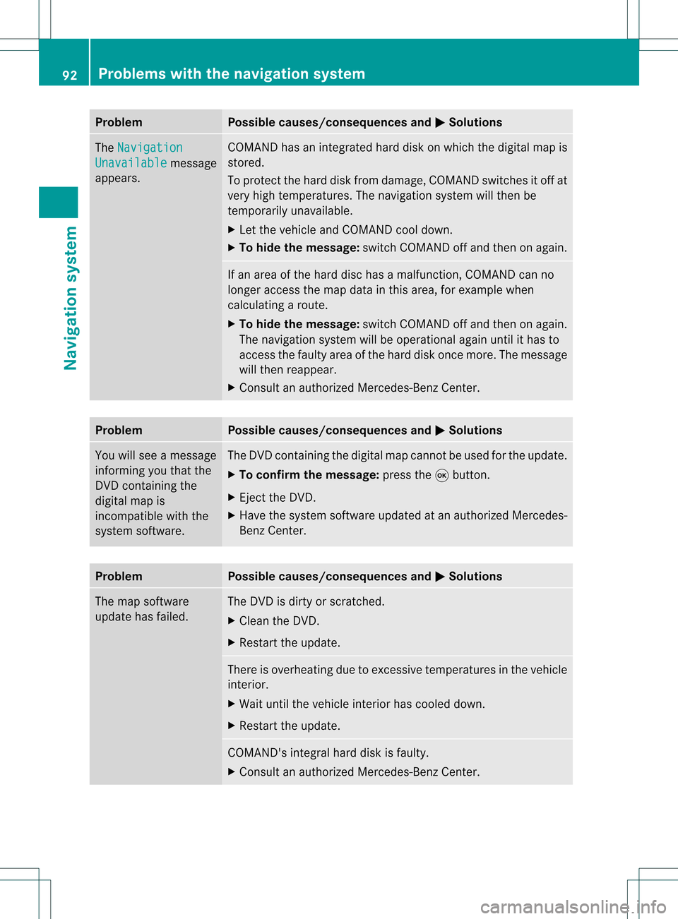
Problem Possible
causes/co nsequences andM Solutions
The
Navigation Unavailable message
appea rs. COMAND
hasanintegrated harddiskonwhich thedigital mapis
stored.
To protect thehard diskfrom damage, COMAND switchesitoff at
very high temperatures. Thenavigation systemwillthen be
temporarily unavailable.
X Let the vehicle andCOMAND cooldown.
X To hide themessage: switchCOMAND offand then onagain. If
an area ofthe hard dischasamalfunction ,COMAND canno
longer access themap data inthis area, forexample when
calculating aroute.
X To hide themessage: switchCOMAND offand then onagain.
The navigation systemwillbeoperational againuntilithas to
access thefaulty areaofthe hard diskonce more. Themessage
will then reappear.
X Consult anauthorized Mercedes-B enzCenter. Problem Possible
causes/co nsequences andM Solutions
You
willsee amessage
informin gyou that the
DVD containing the
digital mapis
incompatible withthe
system software. The
DVD containing thedigital mapcannot beused forthe update.
X To confirm themessage: pressthe9button.
X Ejec tthe DVD .
X Have thesystem software updatedatan authorized Mercedes-
Benz Center. Problem Possible
causes/co nsequences andM Solutions
The
map software
update hasfailed. The
DVD isdirty orscratc hed.
X Clea nthe DVD .
X Restart theupdate. There
isoverheating duetoexcessive temperatures inthe vehicle
interior.
X Wait untilthevehicle interior hascooled down.
X Restart theupdate. COMAND's
integralharddiskisfaulty.
X Consult anauthorized Mercedes-B enzCenter. 92
Problems
withthenavigation systemNavigationsystem
Page 111 of 214
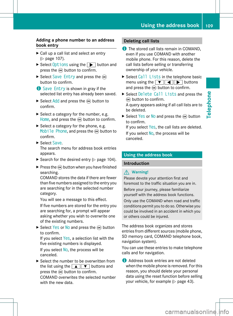
Add
ingaph one num bertoan address
book entry X
Call upacall listand selectan entry
(Y page 107).
X Se lec tOpt ions usin
gth e; buttona nd
pre ssthe 9button toconfi rm.
X Sel ect SaveEnt ry and
pressthe 9
bu tton toconfi rm.
i Sav eEnt ry is
sho wningra yif the
sel ecte dlist entry hasal rea dybeen saved .
X Sel ect Add and
pressthe 9button to
confi rm.
X Sel ect acate goryfor the num ber,e.g .
Hom e ,
and pressthe 9button toconfi rm.
X Sel ect acate goryfor the phone ,e.g .
Mob ile Pho
ne ,
and pressthe 9button to
confi rm.
X Sel ect Save .
The search menu foraddre ssbook entri es
ap pe ars.
X Sea rch forthe desired entry (Ypage 104) .
X Pre ssthe 9button whenyouha ve fini she d
sea rchi ng.
CO MAND storesthe data ifther ear efew er
tha nfive numb ersassign edtothe entryyou
are searc hingforinthe selec tednumb er
cat egory.
You willsee amess agetothis effect .
If five numb ersare stored forthe entryyou
are searc hingfor,a prom ptwill appear
askin gwhet heryou wish toover writeone
of the exis tingnumb ers.
X Selec tYes or
No and
press the9butt on
to con firm .
If you selec tYes ,
a selec tionlistwith the
five existingnumb ersisdisplayed.
If you selec tNo ,
the proc esswillbe
can celed.
X Selec tthe numb erto be over written from
the listusing the9: buttons and
press the9butt ontocon firm .
COMA NDover writesthe selec tednumb er
with thenew data. Deleting
calllists
i The stored calllistsremain inCOMA ND,
even ifyou useCOMA NDwith another
mobile phone.For this reason ,delet ethe
call listsbefor esellin gor transf errin g
owner shipofyour vehic le.
X Selec tCall Lists in
the telep honebasic
men uusing the:=; buttons
and press the9butt ontocon firm .
X Selec tDele teCall Lists and
press the
9 butt ontocon firm .
Aq uery appear sask ing ifall call listsare to
be delet ed.
X Se lec tYes or
No and
pressthe9 button
to confirm .
If you selectYes ,
th ecall listsare delet ed.
If you selectNo ,
th epro ces swill be
can celed. Using
thead dress book Int
rod uction G
Wa
rning!
Pleas edev oteyour attentio nfirst and
for emost tothe traffic situat ionyou arein.
Bef ore your journey, please familiar ize
yourself withtheaddress bookfunctions.
Only usetheCOMA NDwhen roadandtraffic
con dition sperm ityou todo so. Oth erwise you
could beinvolved inan acc ident inwhich you
or oth ers could beinjured.
The address bookorgan izesandstores
ent ries fromd ifferen tsources (mobile phone,
SD memory card,COMAND telephone book,
navigation system).
You canusethese entriestomake telephone
calls andfornavigation.
i Address bookentriesare not deleted
when themobile phoneisremoved. Forthis
reason, youshould deleteyourpersonal
data using thereset functionbefore selling
your vehicle, forexample (Ypage 43). Using
theaddress book
109Telephone Z