MERCEDES-BENZ SLS AMG GT COUPE 2015 C197 Comand Manual
Manufacturer: MERCEDES-BENZ, Model Year: 2015, Model line: SLS AMG GT COUPE, Model: MERCEDES-BENZ SLS AMG GT COUPE 2015 C197Pages: 202, PDF Size: 5.18 MB
Page 81 of 202
Ent
erin gaP OIinthe Vicinity ofthe
Location
X In the map display withthemenu system
displayed, selectDestina tion £
From POIs £
Current Position .
X Contin uebyselect ingthe POI categor y
(Y page 79). Entering
aPOIinthe Vicinity ofa
Specific Location
i Using thisoption youwillgetalist of
alphabetically sortedPOIs thatbelong to
the city entered.
Opt ion 1 X
In the map display withthemenu system
displayed, selectDestina tion £
From POIs £
Other City .
X Ifnec essary proceed asdescribed under
“Select ingaSt ate/Pr ovince”(Y page 66).
X To enter acity: Select City .
The cityinput menu appears.
X Proceed asdescribed inthe “Enterin ga
City” section(Ypage 67).
X Aft erent ering thecity, continue by
select ingthe POI categor y(Y page 79).
Opt ion 2 X
En ter anaddress inthe Enter Dest ination
menu (Ypage 66).
X Select POI .
X Contin uebyselect ingthe POI categor y
(Y page 79). Entering
POIsviaNam eSearch
i This function gives youaccess toall POIs
that areavailable inthe digital map. X
In the map display withthemenu system
displayed (Ypage 57),select Destina tion £
From POIs £
Search ByName .
This displays alist ofall POIs inthe digital
map andthepredict ivespeller.
X Contin ueasdescribed inthe “POI Listwith
Predict iveSpeller” section(Ypage 82). Entering
aPOIvia Phone Number
Search
i This function gives youaccess toall POIs
in the digital mapstoredwith aphone
number.
X In the map display withthemenu system
displayed (Ypage 57),select Destina tion £
From POIs £
Search ByPhone Number .
This displays alist ofall POIs inthe digital
map sortedbyphone number andthe
predict ivespeller.
X Contin ueasdescribed inthe “POI Listwith
Predict iveSpeller” section(Ypage 82). Choosing
aPOICategory
The categor iesand POIs available dependon
the area forwhich youwish toent erthe POI.
R POI inlocal areaofdestin ation:
Alphabetic allysortedcategor iesand POIs
sort edbydistanc ein the vicin ityofthe
destin ationlocation areavailable.
R POI inthe vicin ityofthe location :
Alphabetic allysortedcategor iesand POIs
sort edbydistanc ein the vicin ityofthe
vehicle location areavailable.
R POI inaparticular city:
If you have onlyentered thecount ryand the
city, alphabetically sortedcategor iesand
alphabetically sortedPOIs within thecity
limits areavailable.
If you have entered more thanthecount ry
and thecity, alphabetically sorted
categor iesand POIs sortedbydistanc ein POI
Input
79Navigation Z
Page 82 of 202
the
vicini tyof the addre ssente redare
av ailabl e.
R PO Ivia name search:
An alphabet icallysortedlist ofall POIs is
available.
R POIs viaphon enumb er:
An umer icallysor tedlist isavailab le.
Select ingaCatego ry Depend
ingonthe numbe rofavail able
categori es,the main category listisdispla yed
either withorwithout predictive speller
(Y page 81).
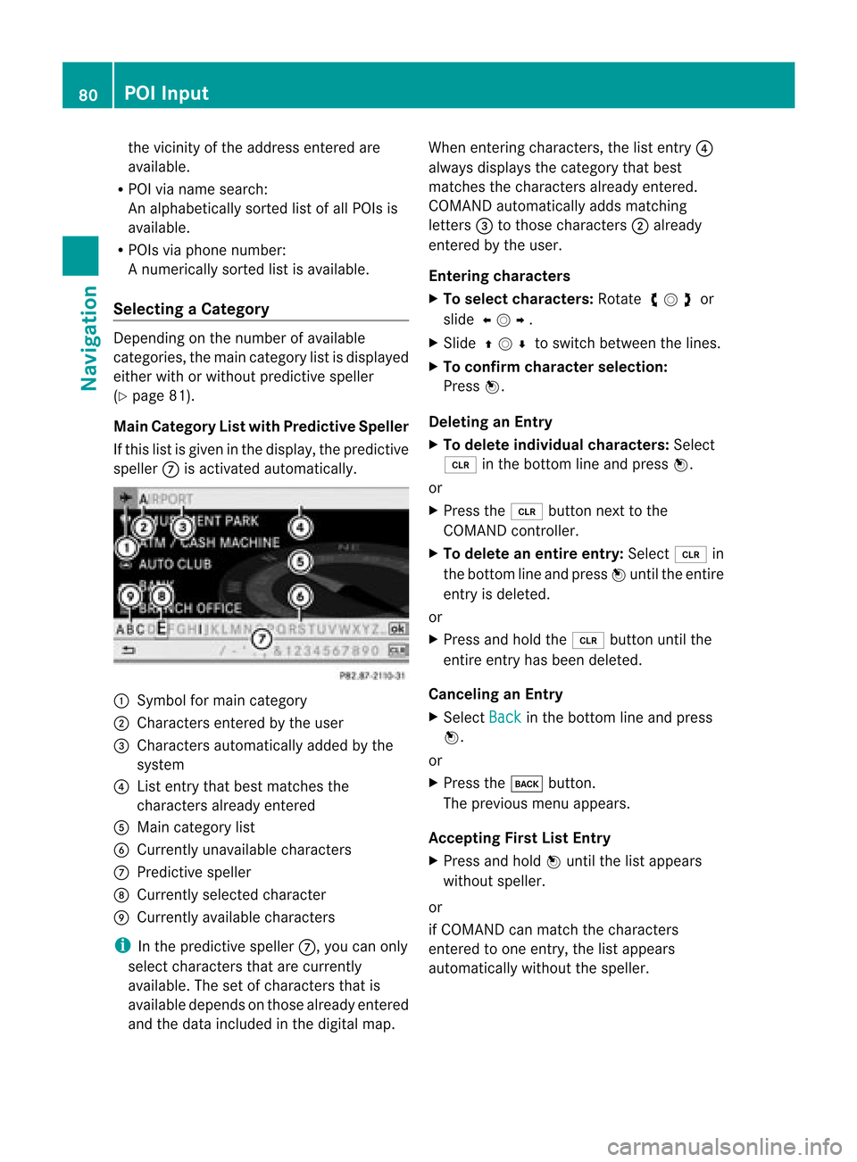
Main Category Listwith Predictive Speller
If this listisgiven inthe displa y,the predictive
speller 7isactivated automaticall y. 1
Symbol formain category
2 Chara ctersentered bythe user
3 Chara ctersautomaticall yadded bythe
system
4 List entry thatbest matches the
characters alreadyentered
5 Main category list
6 Currently unavailablecharacters
7 Predictive speller
8 Currently selectedcharacter
9 Currently available characters
i Inthe predictive speller7,you can only
select characters thatarecurrently
avail able. Thesetofcharacters thatis
avail able depends onthose alreadyentered
and thedata included inthe digital map. When
entering characters, thelistentry 4
alwa ysdispla ysthe category thatbest
matches thecharacters alreadyentered.
COMAND automaticall yadds matching
letters 3tothose characters 2alrea dy
entered bythe user.
Entering characters
X To selec tcharacters: Rotateymzor
slide omp.
X Sli de qmr tosw itch betwe enthe lines .
X To confi rm charac terselecti on:
Pre ssn.
De letin gan Entry
X To del ete indiv idu alch arac ters:Sel ect
õ inthe bottom line and pressn.
or
X Pre ssthe 2 button next tothe
CO MAND controller.
X To del ete anentire entry: Select õ in
the bottom line and pressn unti lthe enti re
entry isde leted .
or
X Pre ssand holdthe 2 button untilthe
enti reentry hasbe en deleted .
Ca ncelin gan Entry
X Sel ect Back in
the bottom line and press
n.
or
X Pre ssthe k button.
Th epre viou smenu appe ars.
Ac ceptin gFirst List Entry
X Pre ssand holdn unti lthe list appe ars
wi tho utspeller.
or
if CO MAND canmatch the character s
ente redtoone entry ,the list appe ars
au toma tically wi tho utthe speller. 80
PO
IIn putNavi gation
Page 83 of 202
Switching
tothe Main Category List
Without Predictive Speller
You canswitch tothe listatany point while
enterin gcharacters.
X Slide qmrepea tedlyuntilthelistapp ears
witho utthe spel ler.
or
X Select dandpress n.
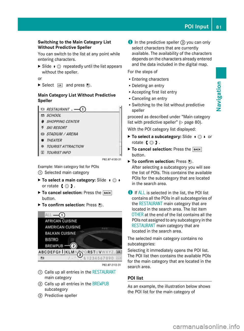
Main Categ oryListWithout Predictive
Spell er Example
:Main categor ylist forPOI s
1 Sele cted main categor y
X To select ama incat egory :Slid eqmr
or rotat eymz.
X To can celse lecti on:Pre ssthe k
bu tton.
X To confi rm selecti on:Pre ssn. 1
Calls up allentri esinthe RESTAURANT ma
incate gory
2 Calls up allentri esinthe BREWPUB su
bca tego ry
3 Predictive speller i
Inthe predictive speller 3 youcan only
sel ect characters thatar ecur rentl y
av ailabl e. The availabi lity of the characters
de pends onthe characters alrea dyente red
and thedata incl uded inthe digital map.
For thestep sof
R Enteri ngcha racters
R Del eting anentry
R Accep tingfirst list entry
R Ca ncel inganentry
R Swi tchi ngtothe list withou tpredi ctive
spel ler
proceed asdescri bedunder “Maincate gor y
list withpred ictive spell er”(Y page 80).
Wit hth ePOI categor ylist displ ayed:
X To select asubcate gory:Slideqmr or
rotat eymz.
X To can celse lecti on:Pre ssthe k
bu tton.
X To confi rm selecti on:Pre ssn.
After selecti ngasu bca tego ryyouwi llsee
the list of POI s.Thi sconta insthe availabl e
POI sfor the subca tego rytha tare loca ted
in the search area.
i IfALL is
sele cted inthe list, thePOI list
contains allthe POIs inall sub categori esof
the RESTAURA NT main
category thatare
loca tedinthe search area.The list item
OTHER at
the end ofthe listcont ains allthe
POIs notassigned toany subcategory inthe
RESTAURANT main
category thatare
located inthe search area.
The selected maincategory contains no
subcategories:
Selectin git immediately opensthePOI list.
The POIlistthen contains theavaila blePOIs
for the main category thatarelocated inthe
search area.
POI list As
anexample, theillustration belowshows
the POI listforthe main category of POI
Input
81Navigat ion Z
Page 84 of 202
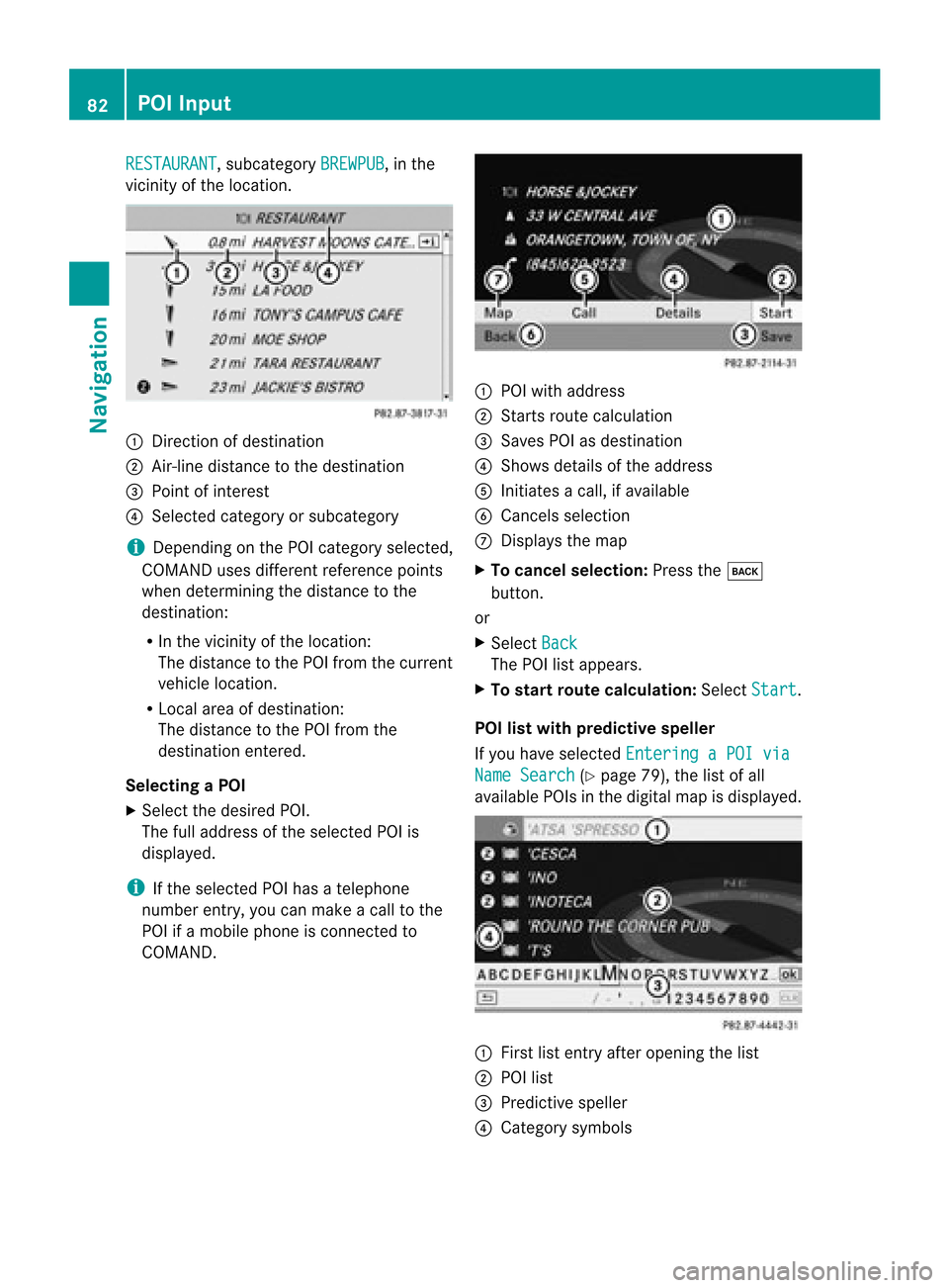
RESTAURANT ,
subcategory BREWPUB ,
in the
vicinity ofthe location. 1
Direction ofdestination
2 Air-line distance tothe destination
3 Point ofinterest
4 Selected categoryorsubcategory
i Depending onthe POI category selected,
COMAND usesdifferent reference points
when determining thedistance tothe
destination:
R In the vicinity ofthe location:
The distance tothe POI from thecurrent
vehicle location.
R Local areaofdestination:
The distance tothe POI from the
destination entered.
Selec tingaPOI
X Select thedesired POI.
The fulladdress ofthe select edPOI is
displayed.
i Ifthe select edPOI hasatelephone
number entry,you can make acall tothe
POI ifamobile phoneiscon nected to
COMAND . 1
POI with address
2 Starts route calculation
3 Saves POIasdestin ation
4 Shows details ofthe address
5 Initiates acall, ifavailable
6 Cancels selection
7 Displays themap
X To cancel selection: Pressthek
button .
or
X Select Back The
POIlistappears.
X To star trout ecalculation: SelectStart .
POI listwith predictive speller
If you have select edEnterin gaPOI via Name
Search (Y
page 79),thelistofall
available POIsinthe digital mapisdisplayed. 1
First listentryafter openin gthe list
2 POI list
3 Predict ivespeller
4 Category symbols 82
POI
InputNavigation
Page 85 of 202
i
Inthe predi ctive speller3 you can only
select characters thatarecurrently
avai lable. The setofcharacters thatis
avai labledepe ndsonthose already entered
and thedata include din the digitalmap.
For thesteps of
R Ent ering characters
R Deleting anentry
R Accepting firstlistentry
R Cancel inganentry
proceed asdescribe dunder “Maincate gor y
list withpred ictive spell er”(Y page 80).
Select ingaPOI
To accept firstlistentry:
X Press andhold nuntil thelistappears
without speller.
or
If COMAND canmatc hthe charact ers
ent ered definit ivelytoone entry,the listis
displayed withoutpredictivespeller withthe
matc hingentryhighlighted. (Ypage 82).
You canswitch tothe listatany point while
ent ering charact ers.
X Slide qmrepea tedlyuntilthelistapp ears
witho utthe spel ler.
or
X Select dandpress n.
X To display thefulladdress ofthe POI:
Select ?andpress n.
X To canc elsel ection: Press thek
button.
or
X Select Back .
The POIlistapp ears.
X To start route calculation :Select Start .
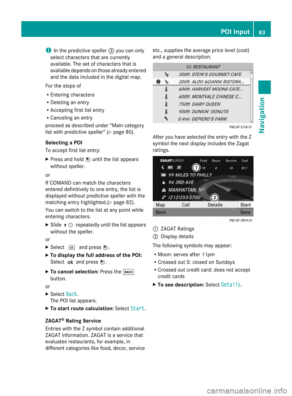
ZAGA T®
Rating Service
Entries withtheZsymb olcontain additiona l
ZAGAT informati on.ZAGAT isaservice that
eval uates restau rants, forexampl e,in
differe ntcategori eslike food, decor, service etc.,
supplies the avera geprice level(cost)
and agenera ldescri ption. After
youhave selected theentry withtheZ
symb olthe next displayinclud esthe Zagat
ratings. 1
ZAGAT Ratings
2 Displ aydetai ls
The followi ngsymb olsmay appear:
R Moon: serves after11pm
R Cross edout S:closed onSunday s
R Cross edout credit card:doesnotaccept
credit cards
X To see desc ription: SelectDetails .POI
Input
83Navigatio n Z
Page 86 of 202

ZAGA
Texam pledesc ription Enter
ingaPOI viatheMap
i Ifthe crosshair sare visible onthe map,
you can enterPOIs inthe vicinit yof the
cr osshair s.Ifthe crosshair sare not visible,
you can enterPOIs inthe vicinit yof the
curr entvehic lelocat ion.
X In the map display withthemen usyst em
displayed (Ypage 57)selec tGuid e .
POIs areavailable:
Depe ndingon the map scale selected,POI
symbols aredisplayed onthe map. The
scale startingat which symbols are
displayed onthe map varies froms ymbo l
to sym bol.
You canselectwhic hsym bols COMA ND
sho ulddisp lay(Ypage 60).The POIneare st
to thece nter ofthesc ree nis sele cted
aut oma tical ly.
No POI savail able:
Ac orrespondin gmessage isdisplay ed.
i This message isalso display edifthe menu
item NoSymbols under
MapDisplay has
been selected (Ypage 60).
X To confirm message: Pressn. 1
Infor mation aboutthehighlighted POI
2 Highlighted POI
X To select aPOI: Select Next or
Previous .
X To star trout ecalculation: SelectStart ,
see also (Ypage 73).
You willbeasked whether thePOI should
be adopted asthe destin ation.
X Select Yes or
No .
Route calculation startsif Yes is
select ed;
a new POIcan bechosen ifNo is
select ed. Rout
eGuida nce General
Notes G
WARN
ING
COMAND calculates theroute tothe
destin ationwithout takingaccount ofthe
following, forexample:
R Traffic lights
R Stop and right- of-way signs
R Lane merging
R Parkin gor stoppin gprohibited areas
R Other roadandtrafficrules andregulations
R Narrow bridges
COMAND maygiveincor rectnavigation
comm andsifthe data inthe digital mapdoes
not corr espond withtheactual road/traffic
situation .For example, ifthe traff icroutin g
has been changed orthe direct ionofaone-
way road hasbeen reversed.
For this reason, youmust alway sobserve
applicable roadandtrafficrules and 84
Rout
eGuid anceNavigation
Page 87 of 202
regu
lations duringyou rjourney. Roadand
traffic rulesandregulations alwayshave
priority overthenavigation commands
generated bythe system.
COMAND guidesyoutothe destination by
means ofdriving recommen dationsinthe
form ofnavigation announcementsor route
guidance displays.
i The route guidance displaysonly appear
if the display hasbeen switched to
navigation mode.
If, for some reason, youdonot follow the
navigation announcementsor ifyou leave the
calculated route,COMAND automatically
calculates anew route tothe destination .
If the map data contains correspon ding
informat ionduring routeguidance, COMAND
tries toavoid roads withlimited passabil ity,
e.g. roads thatareblocked forthrough-t raffic
and areforresidents only. Driving
Maneuver
Drivin gmaneuvers aregiven inthree phases:
R Preparation phase
R Ann ouncemen tphase
R Maneuver phase
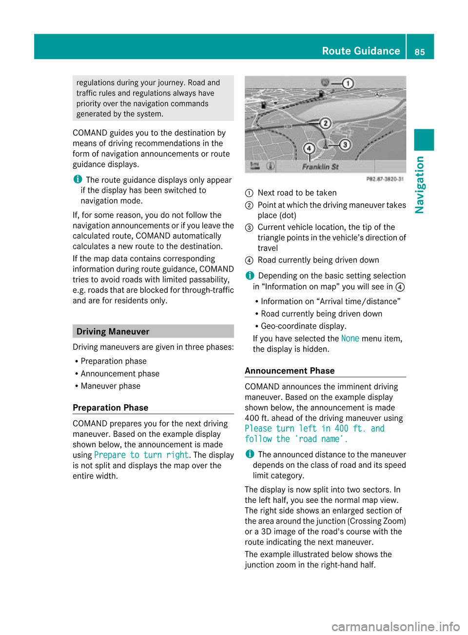
Prepa ration Phase COMAND
preparesyouforthe next driving
maneuver. Basedonthe example display
shown below, theannounc ementismade
using Prepare toturn right .T
he displa y
is not split anddispla ysthe map overthe
entire width. 1
Next roadtobe taken
2 Point atwhich thedriving maneuver takes
place (dot)
3 Current vehiclelocation, thetipofthe
triangle pointsinthe vehicle’s direction of
travel
4 Road current lybeing driven down
i Depending onthe basic settingselection
in “Inform ationonmap” youwillsee in4
R Inform ationon“Arrival time/distanc e”
R Road current lybeing driven down
R Geo-coordinate display.
If you have selected theNone menu
item,
the displa yis hidden.
Announc ementPhase COMAND
announces theimminent driving
maneuver. Basedonthe example display
shown below, theannouncemen tismade
400 ft.ahead ofthe driving maneuver using
Please turnleftin400 ft.and follow
the’road name’. i
The announced distancetothe maneuver
depends onthe class ofroad anditsspeed
limit category.
The displa yis now split intotwosectors. In
the left half, youseethenormal mapview.
The right sideshows anenlarged sectionof
the area around thejunct ion(Crossing Zoom)
or a3D image ofthe road's course withthe
route indicating thenext maneuver.
The example illustrated belowshows the
junct ionzoom inthe right-hand half. Route
Guidance
85Navigation Z
Page 88 of 202
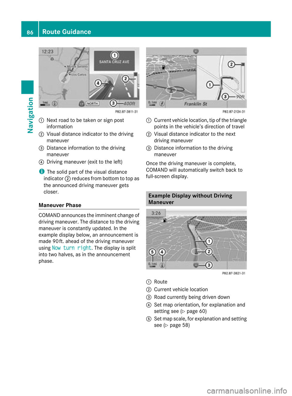
1
Next roadtobe taken orsign post
information
2 Visua ldistance indicator tothe driving
maneuver
3 Distance information tothe driving
maneuver
4 Driving maneuver (exittothe left)
i The solid partofthe visua ldistanc e
indic ator2reduc esfro mb ottom totop as
the announc eddriving maneuver gets
closer.
Maneuver Phase COMAND
announcesthe imminent changeof
driving maneuver. Thedistance tothe driving
maneuver isconst antlyupdated. Inthe
example displaybelow,anannounc ementis
made 90ft.ahead ofthe driving maneuver
using Nowturn right .T
he displa yis split
into twohalves, asinthe announcemen t
phase. 1
Current vehiclelocation, tipofthe triangle
points inthe vehicle’s direction oftravel
2 Visual distance indicator tothe next
driving maneuver
3 Distanc einformation tothe driving
maneuver
Once thedriving maneuver iscomplete,
COMAND willautomatically switchbackto
full-screen display. Example
Displaywithout Driving
Maneuver 1
Route
2 Current vehiclelocation
3 Road current lybeing driven down
4 Set map orientation ,for explanation and
settin gsee (Ypage 60)
5 Set map scale, forexplanation andsettin g
see (Ypage 58) 86
Route
GuidanceNavigat ion
Page 89 of 202
Traffi
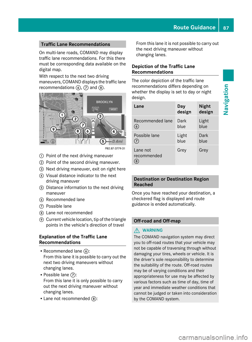
cLan eRec omme ndations
On multi-la ne roa ds,CO MAND maydi sp lay
tra fficlane reco mme ndations. For thisther e
mu stbe corr espond ingdata availabl e on the
di gital map.
Wi th res pect to the next twodriving
ma neu vers,CO MAND disp lays the trafficl ane
rec omm endat ions6, 7and 8. 1
Poin tof thene xt driv ingman euver
2 Poin tofthe second drivingmaneuver.
3 Next driving maneuver, exitonright here
4 Visual distance indicator tothe next
driving maneuver
5 Distanc einformation tothe next driving
maneuver
6 Recommended lane
7 Possible lane
8 Lane notrecommen ded
9 Current vehiclelocation, tipofthe triangle
points inthe vehicle’s direction oftravel
Explanation ofthe Traffic Lane
Recommendat ions R
Recommended lane6:
From thislane itis possible tocarry outthe
next twodriving maneuvers without
changing lanes.
R Possible lane7:
From thislane itis only possible tocarry
out thenext driving maneuver without
changing lanes.
R Lane notrecommen ded8: From
thislane itis not possible tocarry out
the next driving maneuver without
changing lanes.
Depictio nof the Traffic Lane
Recommendat ions The
color depiction ofthe traffic lane
recommen dationsdiffersdepending on
whether thedispla yis set today ornight
design. Lane Day
design Night
design Recommended
lane
6 Dark
blue Light
blue Possible
lane
7 Light
blue Dark
blue Lane
not
recommen ded
8 Grey Grey
Destination
orDestination Region
Reached
Once youhave reached yourdestination, a
check eredflagisdispla yedand route
guida nceisended automatically . Off-r
oadand Off-m ap G
WARNING
The COMAND navigation systemmaydirect
you tooff-road routesthatyour vehicle may
not becapable oftraversing throughwithout
damaging yourtires, wheels orvehicle. Itis
the driver's soleresponsibility todetermine
the suitabili tyof the route. Off-roadroutes
may beofvarying condition sand their
appropriateness foruse may beaffected by
various factorssuchastime ofday, time of
year andimmediate weathercondition sthat
cannot bejudged ortaken intoconsideration
by the COMAND system. Route
Guidance
87Navigation Z
Page 90 of 202
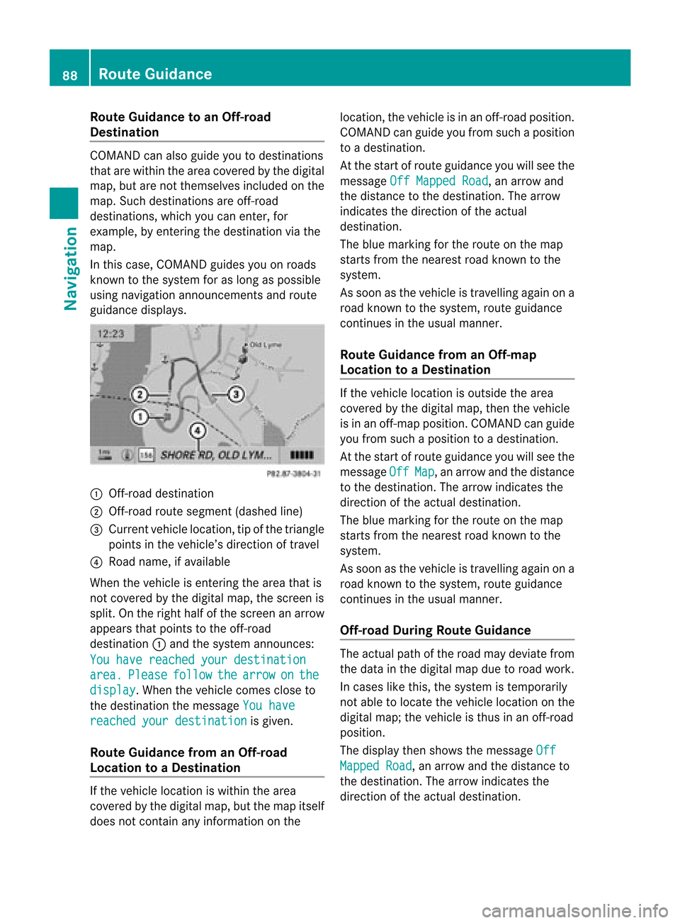
Route
Guidanceto an Off-ro ad
De stin atio n CO
MAND canalso guide yo uto des tina tions
that arewithin theareacovered bythe digital
map, butarenot themselves includedonthe
map. Such destinat ionsareoff-road
destinat ions,which youcan enter ,for
example, byenter ingthe destination viathe
map.
In this case, COMAND guidesyouonroads
known tothe system foraslong aspossible
using navigation announcementsand route
guidance displays. 1
Off- road destinat ion
2 Off- road route segment (dashedline)
3 Current vehiclelocation, tipofthe triangle
points inthe vehicle’s direction oftravel
4 Road name, ifavaila ble
When thevehicle isenter ingthe area thatis
not covered bythe digital map,thescreen is
split. Onthe right halfofthe screen anarrow
appears thatpoints tothe off-road
destinat ion1and thesystem announc es:
You have reached yourdestination area. Please follow the arrow on the
display .W
hen thevehicle comescloseto
the destination themessage Youhave reached
yourdestination is
given.
Route Guidance fromanOff-r oad
Location toaD esti nation If
th eveh icle locat ioniswith inthearea
cov ered bythedigit almap, butthemap itself
does notcon tain anyinform ationon the loc
atio n,thevehi cleisin an off-road posit ion.
COMA NDcan guide youfrom such aposit ion
to adest ination.
At thest art ofrout eguidan ceyou willsee the
mes sage OffMapped Road ,
an arro wand
th edist anceto thedest ination.The arrow
indicates thedirection ofthe actual
destination.
The blue marking forthe route onthe map
starts fromthenearest roadknown tothe
system.
As soon asthe vehicle istravelling againona
road known tothe system, routeguidance
cont inues inthe usua lmanner.
Route Guidance fromanOff-m ap
Location toaD esti nation If
th evehi clelocatio niso uts ide thearea
co ver edbythedigit almap, then theveh icle
is in an off-map posi tion .C OMAND canguide
you from such aposition toadestination.
At the start ofroute guidanceyouwillsee the
message Off Map ,
an arrow andthedistance
to the destination. Thearrow indicates the
direction ofthe actual destination.
The blue marking forthe route onthe map
starts fromthenearest roadknown tothe
system.
As soon asthe vehicle istravelling againona
road known tothe system, routeguidance
continues inthe usualmanner.
Off-road DuringRouteGuidance The
actua lpath ofthe road maydeviatefrom
the data inthe digitalmap duetoroad work.
In cases likethis, thesystem istempora rily
not ableto loca tethe vehicl eloca tion onthe
digi talmap; thevehicl eis thus inan off-road
posi tion.
The displaythen show sthe messa geOff Mapped
Road ,
an arrow andthedista nceto
the destina tion.Thearrow indicatesthe
dire ction ofthe actua ldestina tion. 88
Route
GuidanceNavigatio n