display NISSAN GT-R 2011 Owner's Guide
[x] Cancel search | Manufacturer: NISSAN, Model Year: 2011, Model line: GT-R, Model: NISSAN GT-R 2011Pages: 312, PDF Size: 13.07 MB
Page 39 of 312

Black plate (37,1)
Model "R35-N" EDITED: 2009/ 10/ 30
Example: The widest level(Birdview
TMmap)
INFO:
The traffic information icons are not displayed on
the map screen when the map scale is set to 32
miles (64 km) or higher.“Traffic information display and scale le-
vels” page 6-12
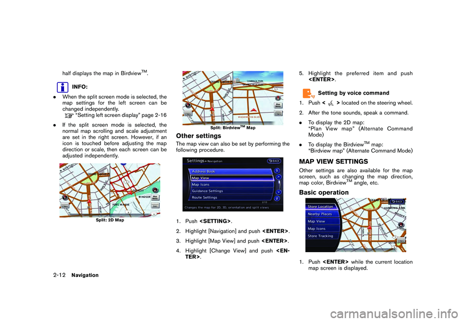
CHANGING MAP VIEWThe map view can be changed between the 2D
and Birdview
TM
maps. The map can also be
displayed in the split screen mode.
1. Push
map screen is displayed.2. Highlight [Map View] and push
3. Highlight [Change View] and push the right
button of the directional buttons.
4. Highlight the preferred map view and push
map view illuminates.
5. The display automatically returns to the map screen.
Available views
. [2D Map]:
Switches to the 2D map.
. [Birdview (3D)]:
Switches to the Birdview
TM
map.
. [Split: 2D Map]:
Changes to the split screen mode and both
halves display maps in 2D.
. [Split: Birdview Map]:
Changes to the split screen mode and the
left half displays the map in 2D and the right
Navigation
2-11
Page 40 of 312

Black plate (38,1)
Model "R35-N" EDITED: 2009/ 10/ 30
half displays the map in Birdview
TM.
INFO:
. When the split screen mode is selected, the
map settings for the left screen can be
changed independently.“Setting left screen display” page 2-16
. If the split screen mode is selected, the
normal map scrolling and scale adjustment
are set in the right screen. However, if an
icon is touched before adjusting the map
direction or scale, then each screen can be
adjusted independently.
Split: 2D Map
Split: Birdview
TMMap
Other settingsThe map view can also be set by performing the
following procedure.1. Push
2. Highlight [Navigation] and push
3. Highlight [Map View] and push
4. Highlight [Change View] and push
Setting by voice command
1. Push <
>located on the steering wheel.
2. After the tone sounds, speak a command.
. To display the 2D map:
“Plan View map” (Alternate Command
Mode)
. To display the Birdview
TM
map:
“Birdview map” (Alternate Command Mode)
MAP VIEW SETTINGSOther settings are also available for the map
screen, such as changing the map direction,
map color, Birdview
TM
angle, etc.
Basic operation1. Push
map screen is displayed.
2-12
Navigation
Page 41 of 312
![NISSAN GT-R 2011 Owners Guide Black plate (39,1)
Model "R35-N" EDITED: 2009/ 10/ 30
2. Highlight [Map View] and push<ENTER>.3. Highlight [Map Settings] and push <EN-
TER>.
4. Highlight the preferred item and push <ENTER> .
Availab NISSAN GT-R 2011 Owners Guide Black plate (39,1)
Model "R35-N" EDITED: 2009/ 10/ 30
2. Highlight [Map View] and push<ENTER>.3. Highlight [Map Settings] and push <EN-
TER>.
4. Highlight the preferred item and push <ENTER> .
Availab](/img/5/58175/w960_58175-40.png)
Black plate (39,1)
Model "R35-N" EDITED: 2009/ 10/ 30
2. Highlight [Map View] and push
4. Highlight the preferred item and push
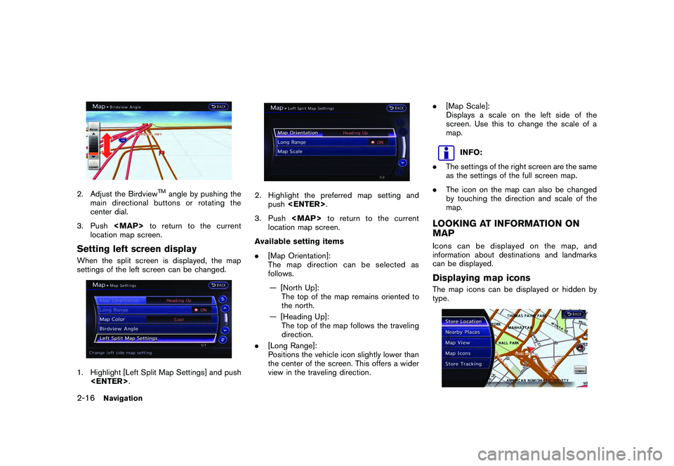
Available setting items
. [Map Orientation]:
Sets the map direction to North Up or
Heading Up.
“Setting map orientation” page 2-14
. [Long Range]:
Sets the long range map view display on/off.“Settings long range map view” page
2-14
. [Map Color]:
Changes the map color.“Setting map color” page 2-15
. [Birdview Angle]:
Changes the Birdview
TM
angle.
“Changing Birdview
TM
angle” page 2-
15 .
[Left Split Map Settings]:
Sets the map settings for the left screen of
the split map.
“Setting left screen display” page 2-16
. [Show all Freeway Exits on Route]/[Auto.
Show Turn List on Freeway]:
Sets the display of the freeway exit informa-
tion on/off.“Show exit information on freeways”
page 2-52
Other settings:The orientation of the map can also be set by
performing the following procedure.1. Push
2. Highlight [Navigation] and push
3. Highlight [Map View] and push
Navigation
2-13
Page 42 of 312

Black plate (40,1)
Model "R35-N" EDITED: 2009/ 10/ 30
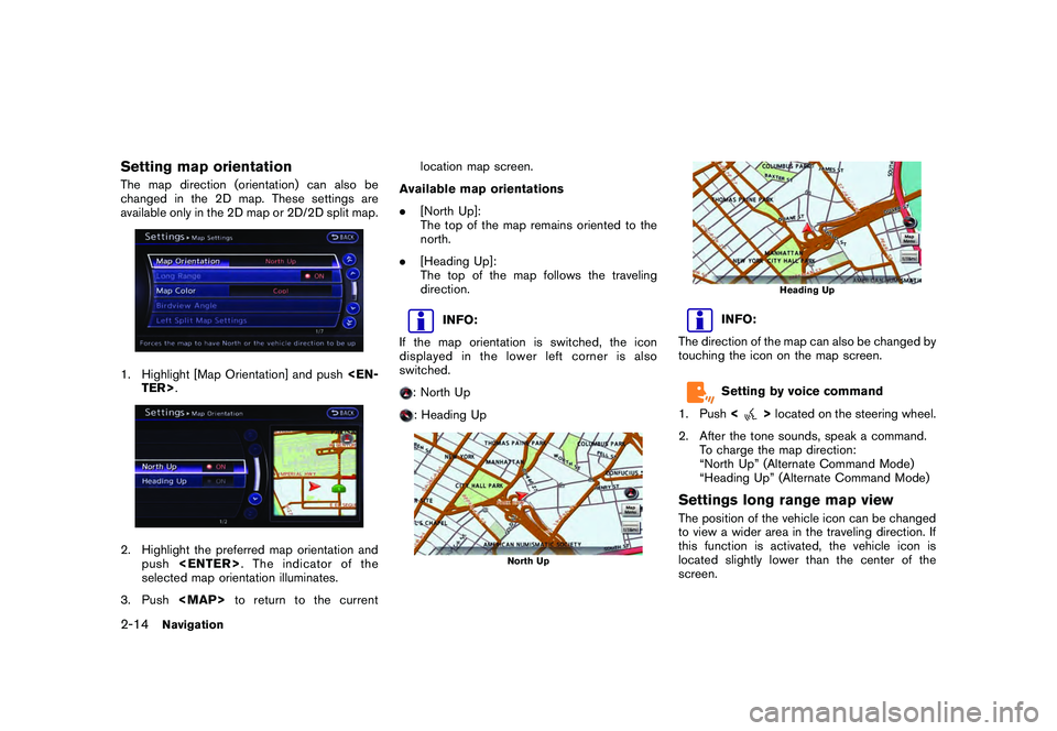
Setting map orientationThe map direction (orientation) can also be
changed in the 2D map. These settings are
available only in the 2D map or 2D/2D split map.1. Highlight [Map Orientation] and push
selected map orientation illuminates.
3. Push
Page 43 of 312
![NISSAN GT-R 2011 Owners Guide Black plate (41,1)
Model "R35-N" EDITED: 2009/ 10/ 30
1. Highlight [Long Range] and push<EN-
TER>. The indicator illuminates.
2. Push <MAP>to return to the current
location map screen.
Long Range Map NISSAN GT-R 2011 Owners Guide Black plate (41,1)
Model "R35-N" EDITED: 2009/ 10/ 30
1. Highlight [Long Range] and push<EN-
TER>. The indicator illuminates.
2. Push <MAP>to return to the current
location map screen.
Long Range Map](/img/5/58175/w960_58175-42.png)
Black plate (41,1)
Model "R35-N" EDITED: 2009/ 10/ 30
1. Highlight [Long Range] and push
2. Push
Page 44 of 312

Black plate (42,1)
Model "R35-N" EDITED: 2009/ 10/ 30
2. Adjust the Birdview
TM
angle by pushing the
main directional buttons or rotating the
center dial.
3. Push
Page 45 of 312
![NISSAN GT-R 2011 Owners Guide Black plate (43,1)
Model "R35-N" EDITED: 2009/ 10/ 30
1. Push<ENTER> while the current location
map screen is displayed.2. Highlight [Map Icons] and push <ENTER>.3. Highlight the preferred icon and pu NISSAN GT-R 2011 Owners Guide Black plate (43,1)
Model "R35-N" EDITED: 2009/ 10/ 30
1. Push<ENTER> while the current location
map screen is displayed.2. Highlight [Map Icons] and push <ENTER>.3. Highlight the preferred icon and pu](/img/5/58175/w960_58175-44.png)
Black plate (43,1)
Model "R35-N" EDITED: 2009/ 10/ 30
1. Push
map screen is displayed.2. Highlight [Map Icons] and push
between on and off each time
pushed. The indicator of the selected icon
illuminates.
4. Push
location map screen. The activated icons
are displayed on the map.
INFO:
If they are registered in the map data, the brand
icons will be displayed on the map instead of the
general map icons listed below.
Map icons that can be displayed
The following map items can be displayed.
.Restaurant
.Gas Station
.Hotel
.AT M .
Rest Area
Other settings:The map icons can also be set by performing the
following procedure.1. Push
2. Highlight [Navigation] and push
3. Highlight [Map Icons] and push
INFO:
The map icons are not displayed on the map
screen when the map scale is set to 1/4 mile
(500 m) or higher in the 2D map, or to 1 mile (2
km) or higher in the Birdview
TM
map.
Navigation
2-17
Page 46 of 312

Black plate (44,1)
Model "R35-N" EDITED: 2009/ 10/ 30
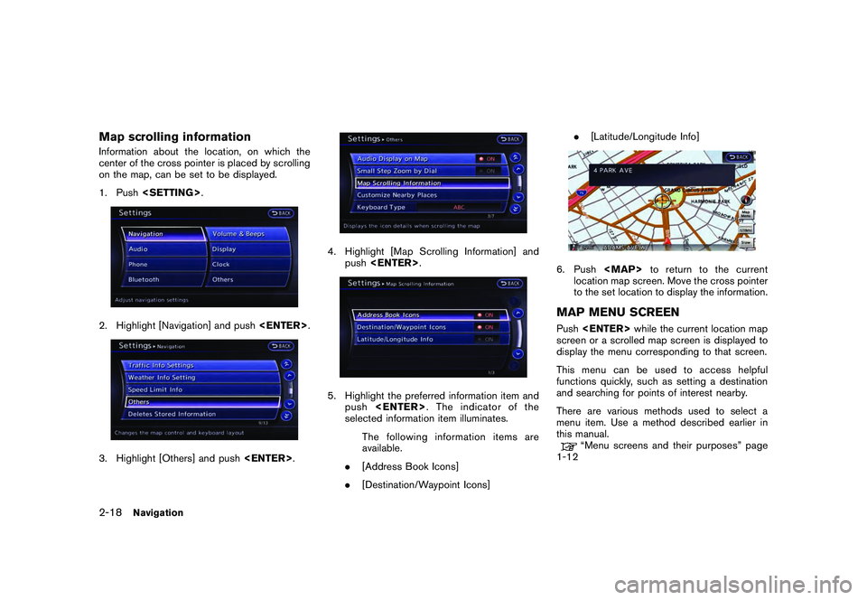
Map scrolling informationInformation about the location, on which the
center of the cross pointer is placed by scrolling
on the map, can be set to be displayed.
1. Push
4. Highlight [Map Scrolling Information] and
push
push
selected information item illuminates.
The following information items are
available.
. [Address Book Icons]
. [Destination/Waypoint Icons] .
[Latitude/Longitude Info]
6. Push
location map screen. Move the cross pointer
to the set location to display the information.MAP MENU SCREENPush
screen or a scrolled map screen is displayed to
display the menu corresponding to that screen.
This menu can be used to access helpful
functions quickly, such as setting a destination
and searching for points of interest nearby.
There are various methods used to select a
menu item. Use a method described earlier in
this manual.
“Menu screens and their purposes” page
1-12
2-18
Navigation
Page 47 of 312
![NISSAN GT-R 2011 Owners Guide Black plate (45,1)
Model "R35-N" EDITED: 2009/ 10/ 30
INFO:
With the touch panel operation, the same
screen can be displayed by touching [Map
Menu] located on the map screen.
Current location map scre NISSAN GT-R 2011 Owners Guide Black plate (45,1)
Model "R35-N" EDITED: 2009/ 10/ 30
INFO:
With the touch panel operation, the same
screen can be displayed by touching [Map
Menu] located on the map screen.
Current location map scre](/img/5/58175/w960_58175-46.png)
Black plate (45,1)
Model "R35-N" EDITED: 2009/ 10/ 30
INFO:
With the touch panel operation, the same
screen can be displayed by touching [Map
Menu] located on the map screen.
Current location map screenIf
location map screen is displayed, the following
options are available.
. [Store Location]:
Stores the current vehicle location in the
Address Book. The stored location can be
retrieved as necessary to set it as a
destination (waypoint) .
“STORING LOCATION” page 2-71
. [Nearby Places]:
Searches for points of interest near the
current vehicle location, such as restaurants
and gas stations, etc.“Finding nearby place” page 2-26 .
[Map View]:
Performs map operations such as the
switching of map type and the setting of
map orientation and scale.
“MAP SETTINGS” page 2-4
. [Map Icons]:
Displays map icons of certain points of
interest (such as restaurants and gas sta-
tions, etc.) on the map around the current
vehicle location.“Displaying map icons” page 2-16
. [Store Tracking]:
Stores in the Address Book the route
travelled from the st arting point to the
current location.“STORING TRACKED ROUTE” page
2-75
Scrolled location map screenIf
screen is displayed, the following options are
available.
. [New Dest.]:
Sets the destination to the map location
where
tion is already set, the location will be set as
the new destination.
“SETTING POINT ON MAP” page 2-
42
. [Add to Route]:
Sets the map location where
was pushed as the destination or a way-
point. This is available only when a sug-
gested route is already set.“Setting destination or waypoint” page
2-56
Navigation
2-19
Page 48 of 312
![NISSAN GT-R 2011 Owners Guide Black plate (46,1)
Model "R35-N" EDITED: 2009/ 10/ 30
.[Nearby Places]:
Searches for points of interest near the map
location where <ENTER>was pushed and
sets them as a destination or waypoint.
Use th NISSAN GT-R 2011 Owners Guide Black plate (46,1)
Model "R35-N" EDITED: 2009/ 10/ 30
.[Nearby Places]:
Searches for points of interest near the map
location where <ENTER>was pushed and
sets them as a destination or waypoint.
Use th](/img/5/58175/w960_58175-47.png)
Black plate (46,1)
Model "R35-N" EDITED: 2009/ 10/ 30
.[Nearby Places]:
Searches for points of interest near the map
location where
sets them as a destination or waypoint.
Use the same search method as the one for
[Places].
“Finding nearby place” page 2-26
. [Store Location]:
Store the map location where
was pushed in the Address Book. The
stored location can be retrieved to set it as
a destination or waypoint.“STORING LOCATION” page 2-71
. [Delete]:
Deletes a stored location. To delete, place
the cross pointer over the corresponding
icon.
. [Incident Detail]:
This function can be selected only when the
traffic information icon is displayed. Displays
the details of the traffic information icon.
Place the cross pointer over the icon to be
checked.
INFO:
Incident details are a feature of Traffic Informa-
tion, and an XM NavTraffic
®
subscription is
required in order to receive Traffic Information.
2-20
Navigation