navigation system NISSAN GT-R 2014 R35 Multi Function Display Manual PDF
[x] Cancel search | Manufacturer: NISSAN, Model Year: 2014, Model line: GT-R, Model: NISSAN GT-R 2014 R35Pages: 314, PDF Size: 7.33 MB
Page 219 of 314
8-10Voice recognition
9. The system makes a call to 800-662-6200.
INFO:
. Speaking “800-662-6200” (10 continuous
digits) or “662-6200” (7 continuous digits)
is acceptable, if the area code is not
necessary. However the 3-3-4 digit group-
ing is recommended for improved recogni-
tion.
“How to speak numbers” (page 8-17)
. The NISSAN voice recognition system is not
limited to recognizing phone numbers of
only 7 or 10 digits. To dial a number in a
format other than the 3-3-4 digit grouping,
use the “International Call” command.
. If “Change Number” is spoken during phone
number entry, the system will automatically
request that the number be repeated using
the 3-3-4 format. In this case please speak the area code first and then follow the
prompts.
. Do not add a “1” in front of the area code
when speaking phone numbers.
. If the system does not recognize a voice
command, please try repeating the com-
mand using a natural voice. Speaking too
slowly or too loudly may further decrease
recognition performance.
Example 2: Placing international call
to phone number 011-81-111-222-
333
1. Push <>located on the steering wheel.
2. The system announces, “Would you like to
access Phone, Navigation, Information,
Audio or Help?”.
3. Speak “Phone”.
4. Speak “International Call”.
5. Speak “01181111222333”.
Page 220 of 314
6. Speak “Dial”.
7. The system makes a call to 011-81-111-222-333.
INFO:
Any digit input format is available in the
International Number input process.
Example 3: Setting destination by
street address
1. Push <>located on the steering wheel.
2. The system announces, “Would you like to
access Phone, Navigation, Information,
Audio or Help?”.
3. Speak “Navigation”.
4. Speak “Address”.
INFO:
Press
the user guide screen.
5. Speak the name of the state, “California”.
6. Speak the name of the city, “Gardena”.
7. Voice feedback will be provided when the command is accepted, and the list of city
names is displayed.
8. After the tone sounds and the icon on the screen changes again, speak “Four”.
Voice recognition8-11
Page 222 of 314
The following section is applicable when Alter-
nate Command Mode is active.
“Setting alternate command mode”
(page 8-22)
When Alternate Command Mode is active, an
expanded list of commands can be used after
pushing <
>. In this mode, available com-
mands are not fully shown on the display or
prompted. Review the expanded command list,
available when this mode is active. See exam-
ples of Alternate Command Mode screens.
Otherwise, it is recommended that Alternate
Command Mode be turned OFF and Standard
Mode be used for the best recognition perfor-
mance.
“Confirming voice commands”
(page 8-13)
DISPLAYING HOW TO OPERATE
VOICE RECOGNITION SYSTEM
When operating the voice recognition system
for the first time or if help is preferred to use the
system, the Command List (available only in
Alternate Command Mode) or the User Guide
are available.
Basic operation
1. Push
2. Highlight [Others] and push
3. Highlight [Voice Recognition] and push
4. Highlight the preferred item and push
.
[Command List]:
A list of voice commands that the system
can accept is displayed.
. [User Guide]:
A simplified operation manual of the voice
recognition system can be displayed and
how to use the voice commands can be
confirmed.
INFO:
The Command List feature is only available when
Alternate Command Mode is active.
Confirming voice commands
When controlling the system by voice com-
mands for the first time or if an appropriate voice
command is unknown, confirm using the voice
command lists.
The following information describes how to
display the navigation command list and the
help list. For information about the operations of
other functions, refer to the vehicle Owner’s
Manual.
Voice recognition8-13
ALTERNATE COMMAND MODE
Page 230 of 314
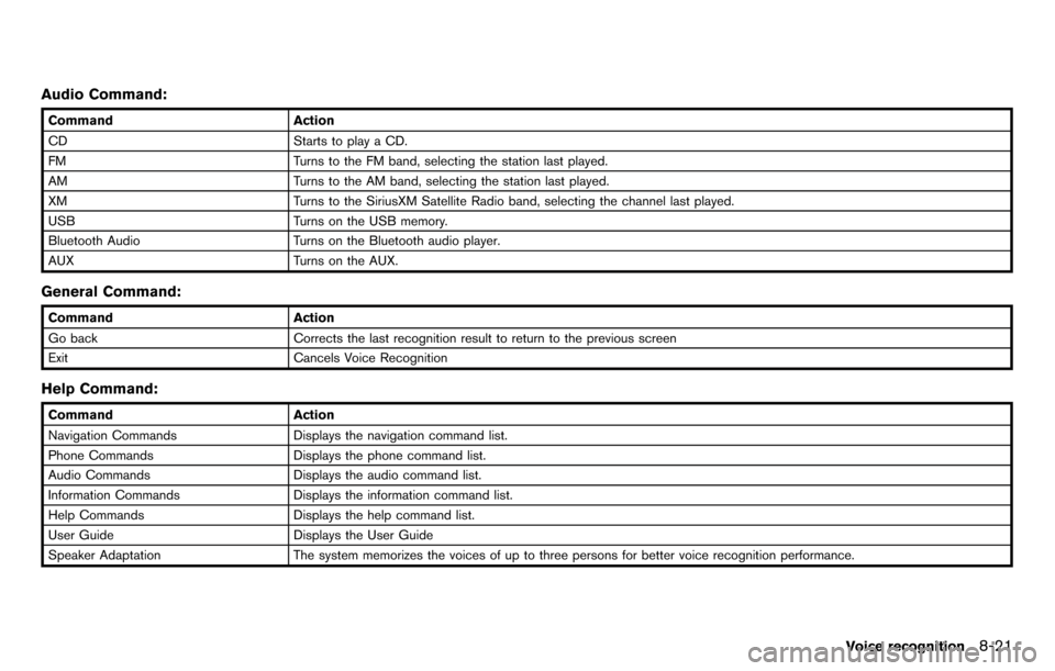
Audio Command:
CommandAction
CD Starts to play a CD.
FM Turns to the FM band, selecting the station last played.
AM Turns to the AM band, selecting the station last played.
XM Turns to the SiriusXM Satellite Radio band, selecting the channel last played.
USB Turns on the USB memory.
Bluetooth Audio Turns on the Bluetooth audio player.
AUX Turns on the AUX.
General Command:
CommandAction
Go back Corrects the last recognition result to return to the previous screen
Exit Cancels Voice Recognition
Help Command:
Command Action
Navigation Commands Displays the navigation command list.
Phone Commands Displays the phone command list.
Audio Commands Displays the audio command list.
Information Commands Displays the information command list.
Help Commands Displays the help command list.
User Guide Displays the User Guide
Speaker Adaptation The system memorizes the voices of up to three persons for better voice recognition performance.
Voice recognition8-21
Page 278 of 314
11 General system information
Current vehicle location ........................................................ 11-2Display of current vehicle location ............................... 11-2
What is GPS (Global Positioning System)? ............. 11-2
Incorrect display of vehicle position ............................. 11-3
Detailed Map Coverage Areas (MCA) for
navigation system.............................................................. 11-5
When gray road is displayed on map ......................... 11-6
Route calculation .................................................................... 11-6
Route guidance ....................................................................... 11-8
Basics of voice guidance ............................................... 11-8
Directions provided and distances to guide points ... 11-8 Repeating voice guidance ......................................... 11-10
Notes on voice guidance ........................................... 11-10
Notes on NavTraffic information ...................................... 11-11
Notes on NavWeatherXM information ........................... 11-12
Map data ........................................................................\
....... 11-13 How to order map data updates ............................. 11-13
About map data ........................................................... 11-13
End-user terms ............................................................. 11-14
How to handle display ....................................................... 11-16
Characteristics of liquid crystal display.................. 11-16
Maintenance of display............................................... 11-17
Page 279 of 314
11-2General system information
DISPLAY OF CURRENT VEHICLE
LOCATION
This navigation system combines the data
obtained from the vehicle (by gyro sensor) and
from GPS (Global Positioning System) satellites
to calculate the current location of the vehicle.
This position is then displayed throughout route
guidance to a destination.
WHAT IS GPS (Global Positioning
System)?
GPS is a position detecting system that uses
satellites deployed by the U.S. government. This
navigation system receives radio signals from
three or more different satellites that orbit
13,049 miles (21,000 km) above the earth in
space, and detects the position of the vehicle by
utilizing the principle of triangulation.
Positioning adjustment
When the system judges that the vehicle
position information is not accurate based on
vehicle speed and gyro sensor data calculations,
the system will automatically adjust the position
of the vehicle icon using GPS signals.
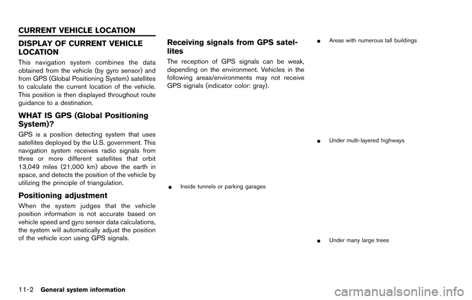
Receiving signals from GPS satel-
lites
The reception of GPS signals can be weak,
depending on the environment. Vehicles in the
following areas/environments may not receive
GPS signals (indicator color: gray) .
*Inside tunnels or parking garages
*Areas with numerous tall buildings
*Under multi-layered highways
*Under many large trees
CURRENT VEHICLE LOCATION
Page 282 of 314
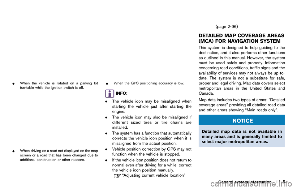
*When the vehicle is rotated on a parking lot
turntable while the ignition switch is off.
*When driving on a road not displayed on the map
screen or a road that has been changed due to
additional construction or other reasons.
*When the GPS positioning accuracy is low.
INFO:
. The vehicle icon may be misaligned when
starting the vehicle just after starting the
engine.
. The vehicle icon may also be misaligned if
different sized tires or tire chains are
installed.
. The system has a function that automatically
corrects the vehicle icon position when it is
misaligned from the actual position.
. Vehicle position correction by GPS may not
function when the vehicle is stopped.
. If the vehicle icon position does not return to
normal even after driving for a while, correct
the vehicle icon position manually.
“Adjusting current vehicle location” (page 2-96)
DETAILED MAP COVERAGE AREAS
(MCA) FOR NAVIGATION SYSTEM
This system is designed to help guiding to the
destination, and it also performs other functions
as outlined in this manual. However, the system
must be used safely and properly. Information
concerning road conditions, traffic signs and the
availability of services may not always be up-to-
date. The system is not a substitute for safe,
proper and legal driving. Map data covers select
metropolitan areas in the United States and
Canada.
Map data includes two types of areas: “Detailed
coverage areas” providing all detailed road data
and other areas showing “Main roads only”.
NOTICE
Detailed map data is not available in
many areas and is generally limited to
select major metropolitan areas.
General system information11-5
Page 283 of 314
11-6General system information
WHEN GRAY ROAD IS DISPLAYED
ON MAP
.When you are driving on a road displayed in
gray after the vehicle has deviated from the
suggested route during route guidance,
automatic rerouting may not start immedi-
ately.
. The navigation system does not provide
route guidance for roads displayed in dark
green. Therefore, if the destination is set on
a road displayed in dark green, the enlarged
map display will return to the ordinary map
screen at some point on a suggested route
that is near the destination. Also, voice
guidance will stop at some point on a
suggested route that is near the destination.
. Places information and street names near
roads displayed in gray may not be con-
tained in the map data.
.There may be cases that carpool lanes are
included on a suggested route when the
automatic rerouting function is activated,
even if the “Use Time Restricted Roads” is
turned off.
“Setting conditions for route calcula-
tion” (page 2-65)
. The navigation system does not provide
route guidance for roads displayed in dark
green.
. If the destination is set on a dark green road,
the enlarged map display will switch to the
ordinary map screen at some point and
suggest a route that is near the destination.
The distance and direction to the endpoint
of the suggested route will be displayed in
the lower right corner of the screen. Also, at
this time, voice guidance will announce,
“The route to the destination includes roads
through incomplete map areas. Voice gui-
dance will not be provided in these areas”.
When approaching the endpoint of the
suggested route, voice guidance will an-
nounce, “Entering the road with incomplete
map data. Use the direction arrow and
distance information to proceed to your
destination.”
To reach the destination, refer to the map
screen. Always follow actual roads and regulations and drive safely.
. The suggested route may not be the short-
est, nor are other circumstances such as
traffic jams considered.
. Because of the inevitable difference in road
conditions and circumstances between the
time you use this system and the time the
information was produced for the map data,
there may be discrepancies in roads and
regulations. In such cases, follow the actual
information available.
. During route calculation, the map will not
scroll, however the vehicle icon will move
with the actual vehicle’s movement.
. During route calculation, buttons such as
Page 285 of 314
11-8General system information
INFO:
The system will only announce street names
when the system language is set to English.
Street names are not announced when the
system is set to Franc¸ ais (French).
BASICS OF VOICE GUIDANCE
Voice guidance announces which direction to
turn when approaching an intersection in which
a turn is necessary.
NOTICE
. There may be some cases in which
voice guidance and actual road
conditions do not correspond. This
may occur because of discrepancies
between the actual road and the
information on the map data, or it is
due to the vehicle’s speed.
. In case voice guidance does not
correspond to the actual road con-
ditions, follow the information ob-
tained from traffic signs or notices
on the road.
. Route guidance provided by the
navigation system does not take
carpool lane driving into considera- tion, especially when carpool lanes
are separated from other road
lanes.
DIRECTIONS PROVIDED AND DIS-
TANCES TO GUIDE POINTS
Directions will differ, depending on the road
type.
Notification of intersection on or-
dinary road
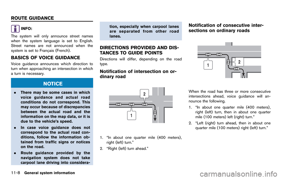
1. “In about one quarter mile (400 meters) ,
right (left) turn.”
2. “Right (left) turn ahead.”
Notification of consecutive inter-
sections on ordinary roads
When the road has three or more consecutive
intersections ahead, voice guidance will an-
nounce the following.
1. “In about one quarter mile (400 meters) , right (left) turn, then in about one quarter
mile (100 meters) left (right) turn.”
2. “Left (right) turn ahead, then in about one quarter mile (100 meters) right (left) turn.”
ROUTE GUIDANCE
Page 290 of 314
HOW TO ORDER MAP DATA UP-
DATES
To order updated map data, contact the
NISSAN NAVIGATION SYSTEM HELPDESK.
See the contact information on the inside front
cover of this manual.
ABOUT MAP DATA
1. This map data has been prepared byHITACHI, LTD. under licence from ZENRIN
CO., LTD. and NAVTEQ. ZENRIN CO., LTD.
has added, processed and digitized data
based on the digital road map data of
Navigation Technologies Corporation. Due
to the production timing of the map data,
some new roads may not be included in this
map data or some of the names or roads
may be different from those at the time you
use this map data.
2. Traffic control and regulation data used in this map data may be different from those at
the time you use this map data due to the
data production timing. When driving your
vehicle, follow the actual traffic control signs
and notices on the roads.
3. Reproducing or copying this map software is strictly prohibited by law.
Published by Nissan North America, Inc.
*C2006 Navigation Technologies. All rights
reserved.
Certain business data provided by infoUSA, Inc.,
Omaha, NE, Copyright
*C1993-2008 NAVTEQ. All Rights Reserved.
*C2008, All Rights Reserved.
*CZENRIN CO., LTD. 2009. All rights reserved.
*CZENRIN USA, INC. 2008. All rights reserved.
*C2008 Zagat Survey, LLC.
WARNING
. This navigation system should not
be used to replace your own judge-
ment. No itinerary suggested by this
navigation system should ever over-
ride any highway regulations, your
own judgement, or a knowledge of
safe driving practices. Do not follow
the navigation system’s suggested
itinerary if it would cause you to
perform a dangerous or illegal act,
place you in a dangerous situation,
or take you into an area you con-
sider unsafe. .
The advice provided by the naviga-
tion system is to be regarded as a
suggestion only. There may be
times when the navigation system
displays the vehicle’s location in-
correctly, fails to suggest the short-
est route, or fails to direct you to the
your desired destination. In such
instances, rely on your own driving
judgement, taking into account the
driving conditions at the time.
. Do not use the navigation system to
locate emergency services. The da-
tabase does not contain a complete
listing of emergency services such
as police stations, fire halls, hospi-
tals and walk-in clinics. Please
show discretion and ask for direc-
tions in such instances.
. As the driver, you alone are respon-
sible for your driving safety.
— In order to avoid a traffic acci-
dent, do not operate the system
while driving.
— In order to avoid a traffic acci- dent, operate the system only
when the vehicle is stopped at a
safe place and the parking
General system information11-13
MAP DATA