gas type NISSAN MAXIMA 2008 A34 / 6.G 06IT Navigation Manual
[x] Cancel search | Manufacturer: NISSAN, Model Year: 2008, Model line: MAXIMA, Model: NISSAN MAXIMA 2008 A34 / 6.GPages: 217, PDF Size: 6.62 MB
Page 16 of 217

Black plate (19,1)
Model "NAV2-N" EDITED: 2007/ 3/ 9
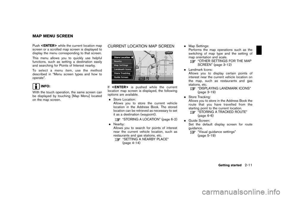
Push
screen or a scrolled map screen is displayed to
display the menu corresponding to that screen.
This menu allows you to quickly use helpful
functions, such as setting a destination easily
and searching for Points of Interest nearby.
To select a menu item, use the method
described in “Menu screen types and how to
operate”.
INFO:
With the touch operation, the same screen can
be displayed by touching [Map Menu] located
on the map screen.
CURRENT LOCATION MAP SCREEN
If
location map screen is displayed, the following
options are available.
.Store Location:
Allows you to store the current vehicle
location in the Address Book. The stored
location can be retrieved as necessary to set
it as a destination (waypoint) .
“STORING A LOCATION” (page 6-2)
.Nearby:
Allows you to search for points of interest
near the current vehicle location, such as
restaurants and gas stations, etc.
“SETTING A NEARBY PLACE”
(page 4-14).Map Settings:
Performs the map operations such as the
switching of map type and the setting of
map orientation and scale.
“OTHER SETTINGS FOR THE MAP
SCREEN” (page 3-12)
.Landmark Icons:
Allows you to display certain points of
interest near the current vehicle location on
the map, such as restaurants and gas
stations, etc.
“DISPLAYING LANDMARK ICONS”
(page 3-19)
.Store Tracking:
Allows you to store in the Address Book the
route that you have travelled from the
starting point to the current location.
“STORING A TRACKED ROUTE”
(page 6-6)
.Guide Screen:
Set the default display screen for route
guidance.
“Visual guidance settings”
(page 5-19)
MAP MENU SCREEN
Getting started2-11
Page 52 of 217
![NISSAN MAXIMA 2008 A34 / 6.G 06IT Navigation Manual Black plate (55,1)
Model "NAV2-N" EDITED: 2007/ 3/ 9
Other settings
You can also change the scale of the left screen
using the following procedure.
1) Push<SETTING>.
2) Highlight [Navigation] and push NISSAN MAXIMA 2008 A34 / 6.G 06IT Navigation Manual Black plate (55,1)
Model "NAV2-N" EDITED: 2007/ 3/ 9
Other settings
You can also change the scale of the left screen
using the following procedure.
1) Push<SETTING>.
2) Highlight [Navigation] and push](/img/5/795/w960_795-51.png)
Black plate (55,1)
Model "NAV2-N" EDITED: 2007/ 3/ 9
Other settings
You can also change the scale of the left screen
using the following procedure.
1) Push
2) Highlight [Navigation] and push
3) Highlight [Map Settings] and push
4) Highlight [Left Settings] or [Right Settings]
and push
information about destinations or landmarks.
DISPLAYING LANDMARK ICONS
This allows you to display or hide the landmark
icons by type.
Landmark icons that can be displayed
.Restaurant
.
Gas Station
.
Hotel
.
AT M
.
Rest Area
1. Push
map screen is displayed.
2. Highlight [Landmark Icons] and push
LOOKING AT INFORMATION ON
THE MAP
Map settings3-19
Page 177 of 217

Black plate (184,1)
Model "NAV2-N" EDITED: 2007/ 3/ 9
ROUTE GUIDANCE
The main features of the NISSAN Navigation
System are visual guidance and voice guidance
in selected map coverage areas. Utilizing a
network of GPS (Global Positioning System)
satellites, the NISSAN Navigation System tracks
your location on the map and navigates you to a
preferred location.
Once you set the destination in a map coverage
area, the NISSAN Navigation System will
calculate a route from your current location to
your destination. The real-time map display and
turn-by-turn voice guidance leads the driver
along the route. These features can be espe-
cially helpful when driving to unfamiliar locations.
The system may be unable to set a destination
and/or calculate a route when the destination is
outside the map coverage area. Additionally,
voice guidance may not be available if the
destination is outside the map coverage area.
For more information on how to set a destina-
tion, refer to section 4.
POINTS OF INTEREST (POI) DIREC-
TO RY
The NISSAN Navigation System offers an
extensive Points of Interest (POI) directory in
map coverage areas. This directory includes a
wide variety of destinations ranging from gasstations, ATMs, and restaurants to casinos, ski
resorts, shopping centers and businesses. By
accessing the Points of Interest directory, you
can search for addresses and phone numbers
for a destination, and just by pushing a button,
the NISSAN Navigation System will calculate a
route to the destination.
The POI directory has many uses. For example,
the directory can be sorted by the various types
of restaurants near your current location. If you
need an ATM or gas station, the NISSAN
Navigation System can navigate you to the
closest preferred location.
For more information on how to use the Points of
Interest directory, refer to section 4.
ADDRESS BOOK
The Address Book can store up to 100 locations
from map coverage areas into a personal
directory. This is especially useful for frequently
visited locations, such as clients, relatives and
friends. The Address Book function allows easy
access to frequently visited locations when
setting them as your destination.
For more information on how to use the Address
Book, refer to section 6.
AVOID AREA
The Avoid Area function allows you to identify
areas or freeways that you would like theNISSAN Navigation System to avoid when
calculating routes. For example, if a freeway or
area is always congested with traffic, you can
set the NISSAN Navigation System to calculate
routes that exclude that freeway or area.
For more information on the Avoid Area function,
refer to section 6.
XM®NavTrafficTMINFORMATION
When available the XM®NavTrafficTMInforma-
tion broadcast allows you to avoid delays due to
traffic incidents. Traffic jams, roadwork, closed
roads around your current location, etc. are
represented graphically on the map by icons
depicting the nature of the event. Incidents on
the route are automatically brought to your
attention when you approach them.
The XM
®NavTrafficTMInformation feature, via
the guidance mode, allows you to detour around
traffic problems. For more information on the
XM
®NavTrafficTMInformation feature, please
refer to section 5.
AUTOMATIC REROUTE
If you deviate from the suggested route, the
NISSAN Navigation System will automatically
recalculate a new route to your destination.
For more information on the Automatic reroute
function, refer to section 5.
FEATURES OF THIS NAVIGATION
SYSTEM
10-2General system information