NISSAN XTERRA 2007 N50 / 2.G Navigation Manual
XTERRA 2007 N50 / 2.G
NISSAN
NISSAN
https://www.carmanualsonline.info/img/5/721/w960_721-0.png
NISSAN XTERRA 2007 N50 / 2.G Navigation Manual
Page 56 of 272
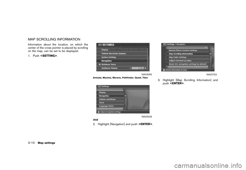
MAP SCROLLING INFORMATION
Information about the location, on which the
center of the cross pointer is placed by scrolling
on the map, can be set to be displayed.
1. Push.
NAV3055Armada, Maxima, Murano, Pathfinder, Quest, Titan
NAV3029350Z
2. Highlight [Navigation] and push.
NAV2752
3. Highlight [Map Scrolling Information] and
push.
3-10Map settings
Page 63 of 272
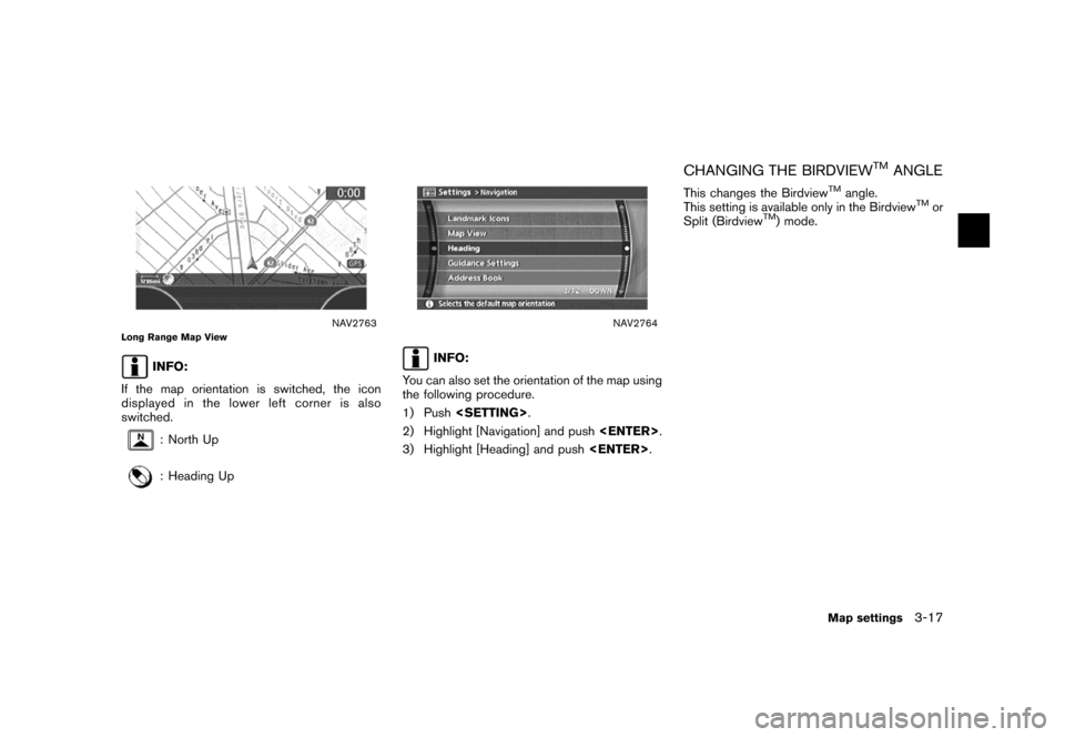
NAV2763Long Range Map View
INFO:
If the map orientation is switched, the icon
displayed in the lower left corner is also
switched.
: North Up
: Heading Up
NAV2764
INFO:
You can also set the orientation of the map using
the following procedure.
1) Push.
2) Highlight [Navigation] and push.
3) Highlight [Heading] and push.
CHANGING THE BIRDVIEWTMANGLE
This changes the BirdviewTMangle.
This setting is available only in the BirdviewTMor
Split (BirdviewTM) mode.
Map settings3-17
Page 65 of 272
NAV2766
4. Adjust the BirdviewTMangle by moving the
cursor in the direction of []or[].5. Push
Page 67 of 272
NAV2767
3. Highlight [Change Map Scale for Left] and
push.
INFO:
[Change Map Scale for Left] is displayed
only when the map view is in the Split (Plan
View) or Split (Birdview
TM) mode.
NAV2768
4. Highlight [Map Scale] and push.
Adjust the map scale by moving the cursor
in the direction of [+] or [−].
Use the joystick to adjust the scale of the
map.
After finishing the setup, pushor
/to apply the scale
setting.
5. Push
Page 69 of 272
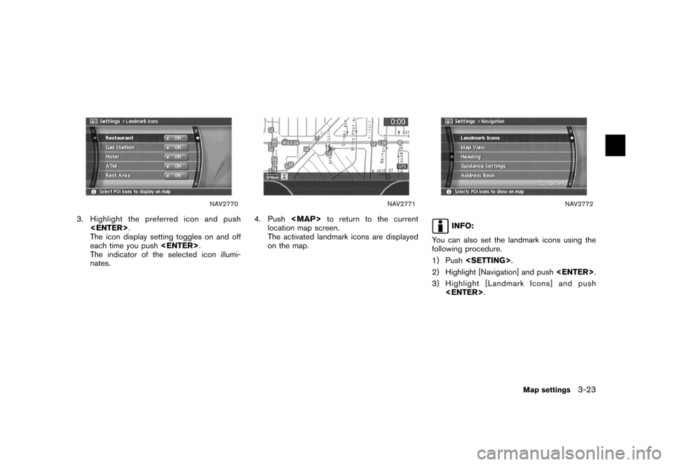
NAV2770
3. Highlight the preferred icon and push
.
The icon display setting toggles on and off
each time you push.
The indicator of the selected icon illumi-
nates.
NAV2771
4. Push
Page 70 of 272
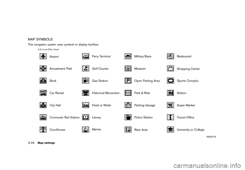
MAP SYMBOLS
This navigation system uses symbols to display facilities.
NAI0416
3-24Map settings
Page 133 of 272
![NISSAN XTERRA 2007 N50 / 2.G Navigation Manual After setting the route, select [Start] to begin
route guidance.
Throughout route guidance, the system navi-
gates you through the guide points using visual
and voice guidance.
CAUTION
The navigation NISSAN XTERRA 2007 N50 / 2.G Navigation Manual After setting the route, select [Start] to begin
route guidance.
Throughout route guidance, the system navi-
gates you through the guide points using visual
and voice guidance.
CAUTION
The navigation](/img/5/721/w960_721-132.png)
After setting the route, select [Start] to begin
route guidance.
Throughout route guidance, the system navi-
gates you through the guide points using visual
and voice guidance.
CAUTION
The navigation system’s visual and voice
guidance is for reference purposes only.
The contents of the guidance may be
inappropriate depending on the situa-
tion.
When driving along the suggested route,
follow all traffic regulations (e.g., one-
way traffic) .
“ROUTE GUIDANCE” (page 9-11)
VOICE GUIDANCE DURING ROUTE
GUIDANCE
When approaching a guide point (intersection or
corner) , destination, etc. during route guidance,
voice guidance announces the remaining dis-
tance and/or turning direction.
Push/to repeat
voice guidance.
NAI0418
Example of voice guidance
&1“In about one quarter mile (400 meters) ,
right (left) turn.”
“Right (left) turn ahead.”
&2“In about one quarter mile (400 meters)
freeway entrance on your right onto (road
number and direction) .”
“Freeway entrance on your right onto (road
number and direction) .”
&3“In about one mile (1.6 kilometers) , exit on
your right.”
“Take the second exit on your right.”
&4“You have arrived at your destination. Ending
route guidance.”
ABOUT ROUTE GUIDANCE
Route guidance5-7
Page 164 of 272
Locations that you often visit can be stored in
the Address Book. The stored locations can be
easily retrieved to set them as a destination or
waypoint.
INFO:
.The Address Book can store up to 100
locations.
.New information placed in the same storage
position will overwrite the old data.
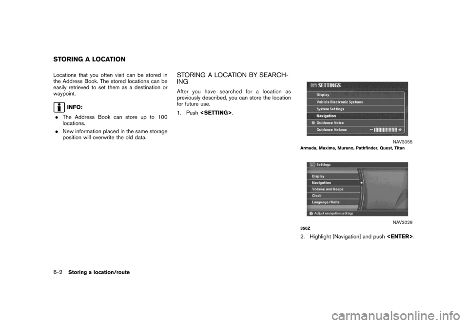
STORING A LOCATION BY SEARCH-
ING
After you have searched for a location as
previously described, you can store the location
for future use.
1. Push.
NAV3055Armada, Maxima, Murano, Pathfinder, Quest, Titan
NAV3029350Z
2. Highlight [Navigation] and push.
STORING A LOCATION
6-2Storing a location/route
Page 169 of 272
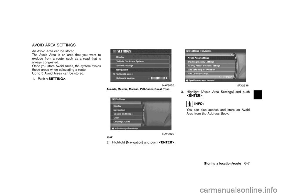
AVOID AREA SETTINGS
An Avoid Area can be stored.
The Avoid Area is an area that you want to
exclude from a route, such as a road that is
always congested.
Once you store Avoid Areas, the system avoids
those areas when calculating a route.
Up to 5 Avoid Areas can be stored.
1. Push.
NAV3055Armada, Maxima, Murano, Pathfinder, Quest, Titan
NAV3029350Z
2. Highlight [Navigation] and push.
NAV2936
3. Highlight [Avoid Area Settings] and push
.
INFO:
You can also access and store an Avoid
Area from the Address Book.
Storing a location/route6-7
Page 175 of 272
NAV2946
4. A confirmation message is displayed. Con-
firm the contents of the message, highlight
[Yes] and push.
The current route is stored.
NAV2947
INFO:
You can also store a route using the following
procedure.
1) Push.
2) Highlight [Navigation] and push.
3) Highlight [Address Book] and push
.
4) Highlight [Stored Routes] and push
.
5) Highlight [None (Add New)] and push
.
INFO:
.The route is stored in the first available
position number in the store current route
list.
.A maximum of 5 routes can be stored.
“DELETING A STORED ITEM”
(page 6-28)
.If you have not set any waypoints on the
route, the route cannot be stored.
Storing a location/route6-13
![NISSAN XTERRA 2007 N50 / 2.G Navigation Manual NAV2766
4. Adjust the BirdviewTMangle by moving the
cursor in the direction of []or[].5. Push<MAP>to return to the current
location map screen.
NAV2764
INFO:
You can also set the Birdview
TMangle usin NISSAN XTERRA 2007 N50 / 2.G Navigation Manual NAV2766
4. Adjust the BirdviewTMangle by moving the
cursor in the direction of []or[].5. Push<MAP>to return to the current
location map screen.
NAV2764
INFO:
You can also set the Birdview
TMangle usin](/img/5/721/w960_721-64.png)
![NISSAN XTERRA 2007 N50 / 2.G Navigation Manual NAV2767
3. Highlight [Change Map Scale for Left] and
push<ENTER>.
INFO:
[Change Map Scale for Left] is displayed
only when the map view is in the Split (Plan
View) or Split (Birdview
TM) mode.
NAV2768 NISSAN XTERRA 2007 N50 / 2.G Navigation Manual NAV2767
3. Highlight [Change Map Scale for Left] and
push<ENTER>.
INFO:
[Change Map Scale for Left] is displayed
only when the map view is in the Split (Plan
View) or Split (Birdview
TM) mode.
NAV2768](/img/5/721/w960_721-66.png)
![NISSAN XTERRA 2007 N50 / 2.G Navigation Manual After setting the route, select [Start] to begin
route guidance.
Throughout route guidance, the system navi-
gates you through the guide points using visual
and voice guidance.
CAUTION
The navigation NISSAN XTERRA 2007 N50 / 2.G Navigation Manual After setting the route, select [Start] to begin
route guidance.
Throughout route guidance, the system navi-
gates you through the guide points using visual
and voice guidance.
CAUTION
The navigation](/img/5/721/w960_721-132.png)
![NISSAN XTERRA 2007 N50 / 2.G Navigation Manual NAV2946
4. A confirmation message is displayed. Con-
firm the contents of the message, highlight
[Yes] and push<ENTER>.
The current route is stored.
NAV2947
INFO:
You can also store a route using the NISSAN XTERRA 2007 N50 / 2.G Navigation Manual NAV2946
4. A confirmation message is displayed. Con-
firm the contents of the message, highlight
[Yes] and push<ENTER>.
The current route is stored.
NAV2947
INFO:
You can also store a route using the](/img/5/721/w960_721-174.png)