navigation SUBARU BRZ 2016 1.G Navigation Manual
[x] Cancel search | Manufacturer: SUBARU, Model Year: 2016, Model line: BRZ, Model: SUBARU BRZ 2016 1.GPages: 336, PDF Size: 10.83 MB
Page 179 of 336
Navigation 177
Further Information
Regarding Vehicle Position Detection
Correction Using Map Matching
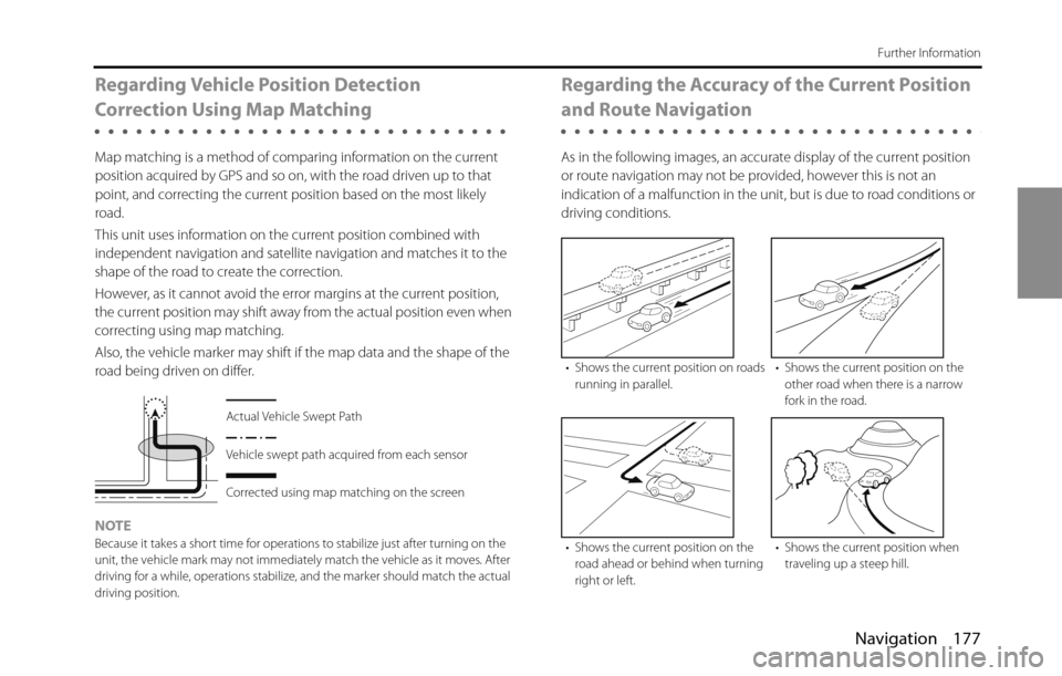
Map matching is a method of comparing information on the current
position acquired by GPS and so on, with the road driven up to that
point, and correcting the current position based on the most likely
road.
This unit uses information on the current position combined with
independent navigation and satellite navigation and matches it to the
shape of the road to create the correction.
However, as it cannot avoid the error margins at the current position,
the current position may shift away from the actual position even when
correcting using map matching.
Also, the vehicle marker may shift if the map data and the shape of the
road being driven on differ.
NOTE
Because it takes a short time for operations to stabilize just after turning on the
unit, the vehicle mark may not immediately match the vehicle as it moves. After
driving for a while, operations stabilize, and the marker should match the actual
driving position.
Regarding the Accuracy of the Current Position
and Route Navigation
As in the following images, an accurate display of the current position
or route navigation may not be provided, however this is not an
indication of a malfunction in the unit, but is due to road conditions or
driving conditions.
Actual Vehicle Swept Path
Vehicle swept path acquired from each sensor
Corrected using map matching on the screen
• Shows the current position on roads
running in parallel.• Shows the current position on the
other road when there is a narrow
fork in the road.
• Shows the current position on the
road ahead or behind when turning
right or left.• Shows the current position when
traveling up a steep hill.
Page 180 of 336
178 Navigation
Further Information
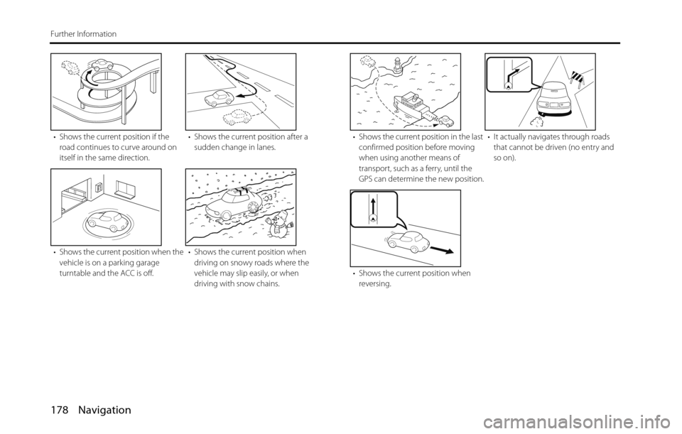
• Shows the current position if the
road continues to curve around on
itself in the same direction.• Shows the current position after a
sudden change in lanes.
• Shows the current position when the
vehicle is on a parking garage
turntable and the ACC is off.• Shows the current position when
driving on snowy roads where the
vehicle may slip easily, or when
driving with snow chains.• Shows the current position in the last
confirmed position before moving
when using another means of
transport, such as a ferry, until the
GPS can determine the new position.• It actually navigates through roads
that cannot be driven (no entry and
so on).
• Shows the current position when
reversing.
Page 181 of 336
Navigation 179
Further Information
Regarding Roads and Place Name Data
Because road and place names may change after the map data has
been created, there may be times when road and place names do not
match.
When no information is available in the map data, function such as
display of road names, searching for facilities, and route guidance
cannot be used.
When maps are created, land surveys are conducted and information
about roads improvement and opening is collected to provide the
most accurate information possible. However, modifications in roads,
place names and facilities may be carried out at any time.
Consequently, we cannot guarantee that map data contains no errors
in road positions, configuration and names, or in facility names.
The navigation system includes a function to read out names of roads,
intersections, and so on during guidance.
Depending on the selected language, names read out by the system
may not be exactly accurate due to missing information in map data.
Regarding Route Navigation
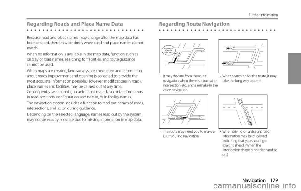
• It may deviate from the route
navigation when there is a turn at an
intersection etc., and a mistake in the
voice navigation.• When searching for the route, it may
take the long way around.
• The route may need you to make a
U-urn during navigation.• When driving on a straight road,
information may be displayed
indicating that you should go
straight ahead. ( When the
intersection shape is not clear and so
on.)
In six tenths
of a mile,
right turm.
Page 182 of 336
180 Navigation
Further Information
•Performing a new search while traveling at high speeds may take
some time.
•The route may not change even after performing another search.
•When isolated locations or roads with no surrounding available
information are set as the current position/destination, you may not
be able to search for a route.
•A route may not be displayed when the current position is close to
the destination.
•Even if you select toll roads as a priority, the route may not guide you
through a toll road.
In a similar way, toll roads may be displayed even if you prioritize
other roads over toll roads.
( When it is possible to select a toll road or a normal road to create
the route, priority is given to the user's toll road preference - use toll
roads, or avoid toll roads.)
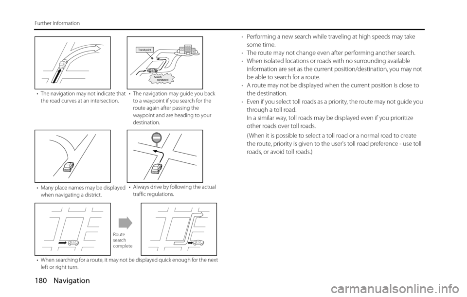
• The navigation may not indicate that
the road curves at an intersection.• The navigation may guide you back
to a waypoint if you search for the
route again after passing the
waypoint and are heading to your
destination.
• Many place names may be displayed
when navigating a district.• Always drive by following the actual
traffic regulations.
• When searching for a route, it may not be displayed quick enough for the next
left or right turn.
Transit point
Search
reinitiated
Route
search
complete
Page 268 of 336
266 Audio and Visual
How to Operate Portable Audio Devices
Using Aha�¥ by HARMAN
About Aha
Aha is a cloud-based app that connects to your car and gives you
access to your favorite web content safely and easily. There are over
30,000 stations spanning internet radio, personalized music,
audiobooks, Facebook, Twitter, restaurant and hotel searches, weather
and more.
For more about Aha, go to aharadio.com.
When connecting iPhone and iPod touch or Android devices with the
Aha application installed, you can control, view, and hear Aha content
through the navigation system in this vehicle. You may be also display
POI information from the Aha application on the navigation system
map screen and route to these POIs.
The following devices can use this function.
•iPhone and iPod touch
•Android�¥ devices
In this chapter, iPhone and iPod touch or Android devices will be
referred to as a smartphone.
WA R N I N G
•For safety reasons, certain functions are not available while
your vehicle is in motion.
•Do not connect or operate the smartphone while driving.
•Be sure to park the vehicle in a safe location before
connecting or operating the smartphone.
CAUTION
• Certain functions (such as touch panel operation and/or
video image) offered by this unit may not be used while
driving.
•Be careful not to exceed the data usage limits for your
smartphone. Doing so will result in additional data usage
charges from your phone carrier.
•If you lose the data in a smartphone or other device while
using it with this unit, no compensation will be given for the
lost data.
•Do not leave smartphone devices inside the vehicle. The
temperature inside the vehicle can often rise to a very high
level in hot weather and it may result in a malfunction of the
device.
•Do not put your weight on the connected smartphone or
put anything on it. Damage could result.
•Never insert any objects other than iPhone/iPod touch
connection cables into the connection slot on the iPhone/
iPod touch. Damage could result.
•In order to maximize signal reception, performance and
precision of the smartphone, please ensure the smartphone
is placed as close to the navigation unit as possible, while
ensuring it is stowed and secure while driving. Never
attempt to operate your smartphone device directly while
driving.
Page 273 of 336
Audio and Visual 271
How to Operate Portable Audio Devices
NOTEThe button display will vary depending on each station or content item. (1) Station List
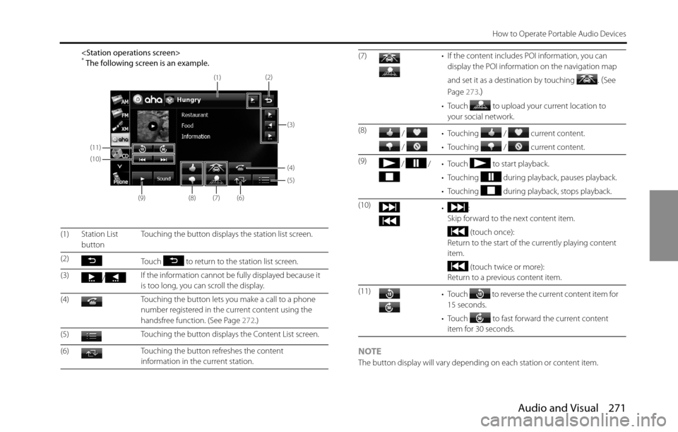
buttonTouching the button displays the station list screen.
(2)
Touch to return to the station list screen.
(3)
/If the information cannot be fully displayed because it
is too long, you can scroll the display.
(4) Touching the button lets you make a call to a phone
number registered in the current content using the
handsfree function. (See Page 272.)
(5) Touching the button displays the Content List screen.
(6) Touching the button refreshes the content
information in the current station.
(11)
(10)
(9)
(8)(7)(6)
(5) (4)
(3) (2)
(1)
(7) • If the content includes POI information, you can
display the POI information on the navigation map
and set it as a destination by touching
. (See
Page 273.
)
• Touch to upload your current location to
your social network.
(8)
/
/ • Touching / current content.
• Touching / current content.
(9)
/ / • Touch to start playback.
• Touching during playback, pauses playback.
• Touching during playback, stops playback.
(10)
•:
Skip forward to the next content item.
(touch once):
Return to the start of the currently playing content
item.
(touch twice or more):
Return to a previous content item.
(11)
• Touch to reverse the current content item for
15 seconds.
• Touch to fast forward the current content
item for 30 seconds.
Page 275 of 336
Audio and Visual 273
How to Operate Portable Audio Devices
■Functions coupled with Aha and the navigation system
Depending on the Stations, functions coupled with the Aha application
and the navigation system may be available.
Setting the destination using Aha
If the content item includes POI location information, you may be
display the POI location information on the navigation map and set it as
a destination.
•When using the route navigation, you need to agree ("I Agree") to
the conditions for using the navigation system.
For details on "I Agree", see “Turning the Power On or Off ” on Page
14.
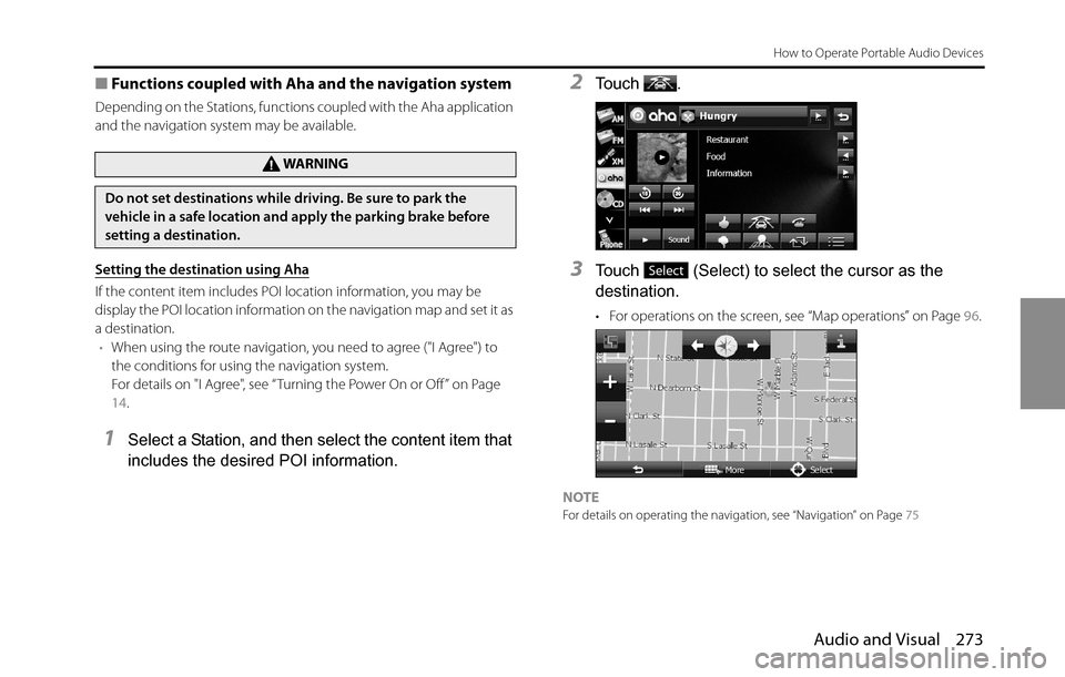
1Select a Station, and then select the content item that
includes the desired POI information.
2To u c h .
3Touch (Select) to select the cursor as the
destination.
• For operations on the screen, see “Map operations” on Page 96.
NOTEFor details on operating the navigation, see “Navigation” on Page 75
WA R N I N G
Do not set destinations while driving. Be sure to park the
vehicle in a safe location and apply the parking brake before
setting a destination.
Select
Page 285 of 336
Other 283
Other Operations
Voice Control System Operations
About the Voice Control System
By using the voice control system (voice input microphone and
button), you can perform navigation and audio operation by saying
voice commands. This enables you to use functions that are usually
inoperable while driving.
The voice control system may not recognize the voice command if you
do not say it correctly.
Be aware of the following points that will assist correct recognition.
•Speak after you hear the “beep”. If you speak before or at the same
time as the “beep”, your command will not be recognized.
•Speak in a loud and clear voice.
•Some voices may be difficult to recognize.
•Keep the windows closed as much as possible while speaking. Noise
such as wind or other external sounds may prevent correct
recognition. Also, if the air conditioner fan is too loud, it may prevent
correct recognition.
•The system does not support regional variations or alternative
phrases. Be sure to say the specified phrases.Under the following conditions, the voice recognition mode will be
turned off:
•Within 8 seconds after guidance, talkback or help voice finishes
playing, no voice is recognized.
( When the screen is operated, counting of 8 seconds starts again
after the screen is touched.)
•The voice recognition button is pressed and held.
•The Steering button or Hard button (excluding the Voice
Recognition button) is pressed.
•A call is received.
NOTE
When voice recognition is started, the current audio output is muted or paused.
Page 288 of 336
286 Other
Other Operations
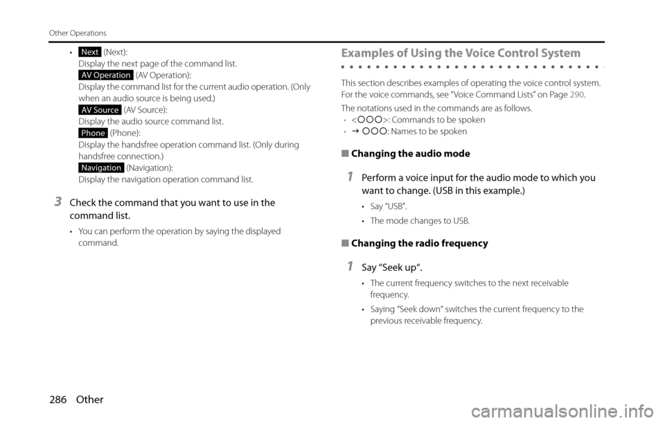
• (Next):
Display the next page of the command list.
(AV Operation):
Display the command list for the current audio operation. (Only
when an audio source is being used.)
(AV Source):
Display the audio source command list.
(Phone):
Display the handsfree operation command list. (Only during
handsfree connection.)
(Navigation):
Display the navigation operation command list.
3Check the command that you want to use in the
command list.
• You can perform the operation by saying the displayed
command.
Examples of Using the Voice Control System
This section describes examples of operating the voice control system.
For the voice commands, see “Voice Command Lists” on Page 290.
The notations used in the commands are as follows.
•<�c�c�c>: Commands to be spoken
•�J �c�c�c: Names to be spoken
■Changing the audio mode
1Perform a voice input for the audio mode to which you
want to change. (USB in this example.)
•Say “USB”.
• The mode changes to USB.
■Changing the radio frequency
1Say “Seek up“.
• The current frequency switches to the next receivable
frequency.
• Saying “Seek down“ switches the current frequency to the
previous receivable frequency.
Next
AV Operation
AV Source
Phone
Navigation
Page 292 of 336
290 Other
Other Operations
Voice Command Lists
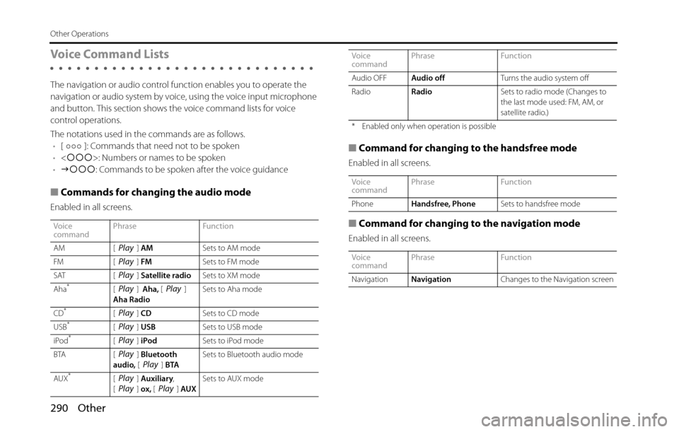
The navigation or audio control function enables you to operate the
navigation or audio system by voice, using the voice input microphone
and button. This section shows the voice command lists for voice
control operations.
The notations used in the commands are as follows.
•[ ]: Commands that need not to be spoken
•<�c�c�c>: Numbers or names to be spoken
•�J�c�c�c: Commands to be spoken after the voice guidance
■Commands for changing the audio mode
Enabled in all screens.
■Command for changing to the handsfree mode
Enabled in all screens.
■Command for changing to the navigation mode
Enabled in all screens.
Voice
commandPhrase Function
AM [ ] AMSets to AM mode
FM [ ] FMSets to FM mode
SAT [ ] Satellite radioSets to XM mode
Aha
*[] Aha, []
Aha RadioSets to Aha mode
CD
*[] CDSets to CD mode
USB*[] USBSets to USB mode
iPod*[] iPodSets to iPod mode
BTA [ ] Bluetooth
audio, [] BTASets to Bluetooth audio mode
AUX
*[] Auxiliary,
[] ox, [] AUXSets to AUX mode
Play
Play
Play
PlayPlay
Play
Play
Play
PlayPlay
PlayPlayPlay
Audio OFFAudio offTurns the audio system off
RadioRadioSets to radio mode (Changes to
the last mode used: FM, AM, or
satellite radio.)
* Enabled only when operation is possible
Voice
commandPhrase Function
PhoneHandsfree, PhoneSets to handsfree mode
Voice
commandPhrase Function
NavigationNavigationChanges to the Navigation screen Voice
commandPhrase Function