TOYOTA PRIUS C 2015 NHP10 / 1.G Navigation Manual
Manufacturer: TOYOTA, Model Year: 2015, Model line: PRIUS C, Model: TOYOTA PRIUS C 2015 NHP10 / 1.GPages: 285, PDF Size: 4.97 MB
Page 211 of 285
212
2. DESTINATION SEARCH
1Display the “Destination” screen.
(P.206)
2Select “Previous Destinations” .
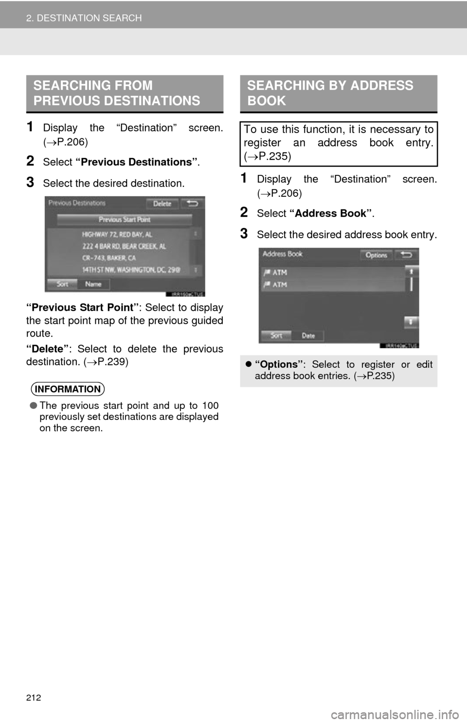
3Select the desired destination.
“Previous Start Point” : Select to display
the start point map of the previous guided
route.
“Delete” : Select to delete the previous
destination. ( P.239)1Display the “Destination” screen.
(P.206)
2Select “Address Book” .
3Select the desired address book entry.
SEARCHING FROM
PREVIOUS DESTINATIONS
INFORMATION
●The previous start point and up to 100
previously set destinations are displayed
on the screen.
SEARCHING BY ADDRESS
BOOK
To use this function, it is necessary to
register an address book entry.
(P.235)
“Options” : Select to register or edit
address book entries. ( P.235)
Page 212 of 285
213
2. DESTINATION SEARCH
NAVIGATION SYSTEM
8
1Display the “Destination” screen.
(P.206)
2Select “Emergency” .
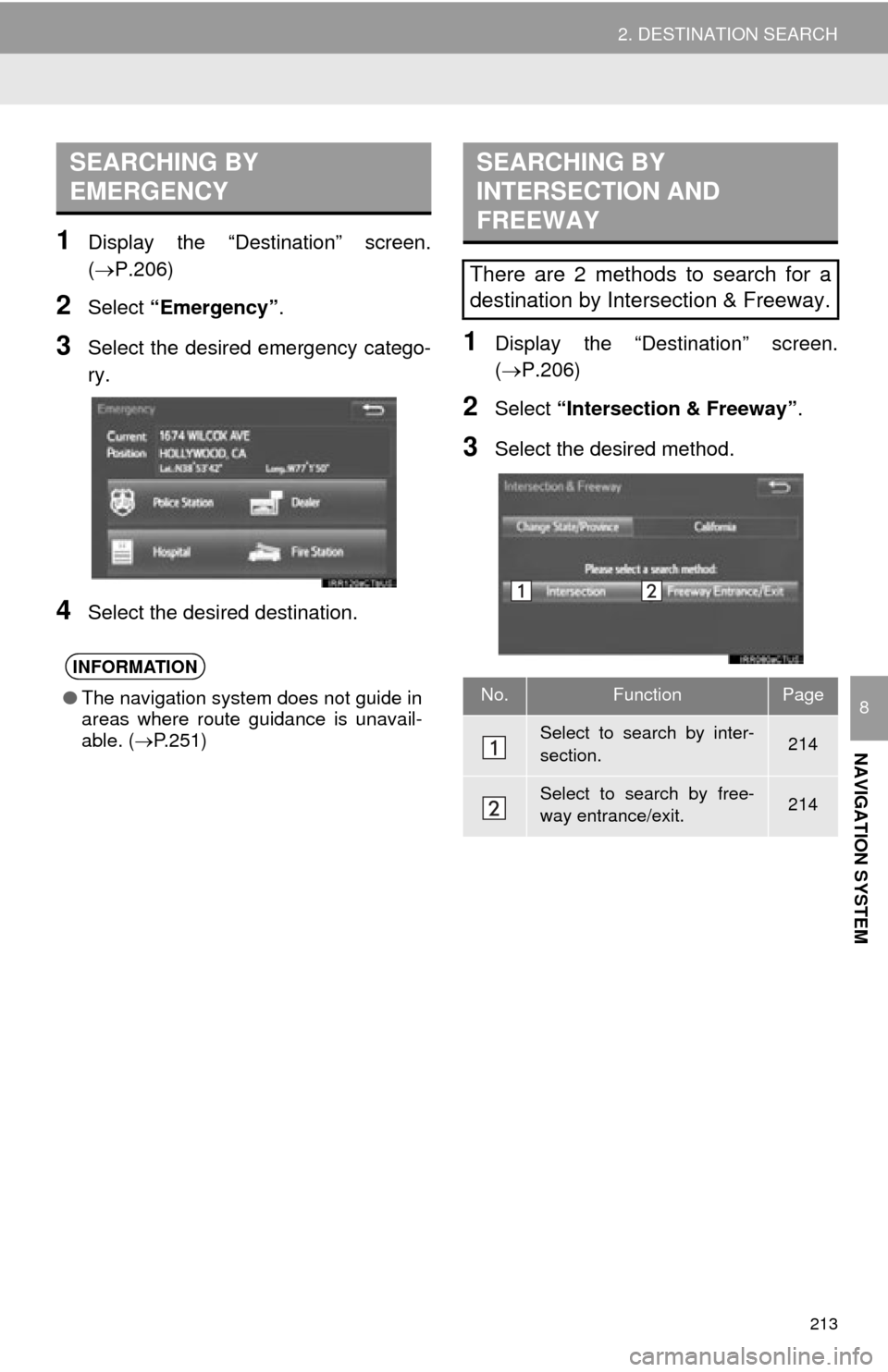
3Select the desired emergency catego-
ry.
4Select the desired destination.
1Display the “Destination” screen.
(P.206)
2Select “Intersection & Freeway” .
3Select the desired method.
SEARCHING BY
EMERGENCY
INFORMATION
●The navigation system does not guide in
areas where route guidance is unavail-
able. ( P.251)
SEARCHING BY
INTERSECTION AND
FREEWAY
There are 2 methods to search for a
destination by Intersection & Freeway.
No.FunctionPage
Select to search by inter-
section.214
Select to search by free-
way entrance/exit.214
Page 213 of 285
214
2. DESTINATION SEARCH
1Select “Intersection” .
2Enter the name of the first intersecting
street which is located near the desti-
nation and select “OK”.
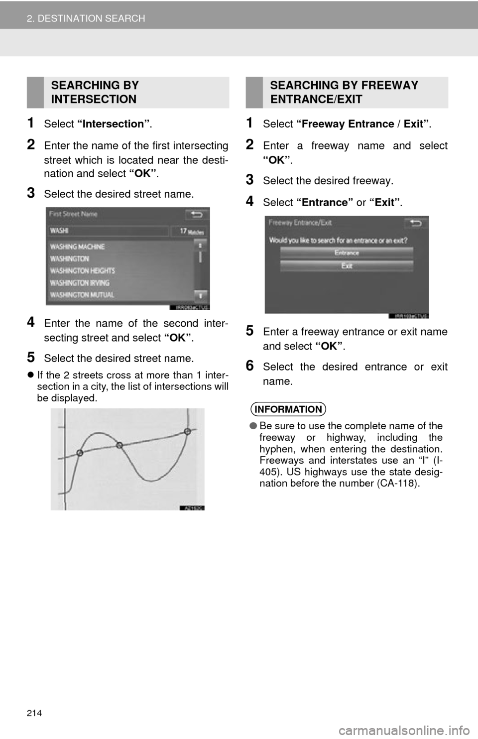
3Select the desired street name.
4Enter the name of the second inter-
secting street and select “OK”.
5Select the desired street name.
If the 2 streets cross at more than 1 inter-
section in a city, the list of intersections will
be displayed.
1Select “Freeway Entrance / Exit” .
2Enter a freeway name and select
“OK”.
3Select the desired freeway.
4Select “Entrance” or “Exit”.
5Enter a freeway entrance or exit name
and select “OK”.
6Select the desired entrance or exit
name.
SEARCHING BY
INTERSECTIONSEARCHING BY FREEWAY
ENTRANCE/EXIT
INFORMATION
●Be sure to use the complete name of the
freeway or highway, including the
hyphen, when entering the destination.
Freeways and interstates use an “I” (I-
405). US highways use the state desig-
nation before the number (CA-118).
Page 214 of 285
215
2. DESTINATION SEARCH
NAVIGATION SYSTEM
8
1Display the “Destination” screen.
(P.206)
2Select “Map”.
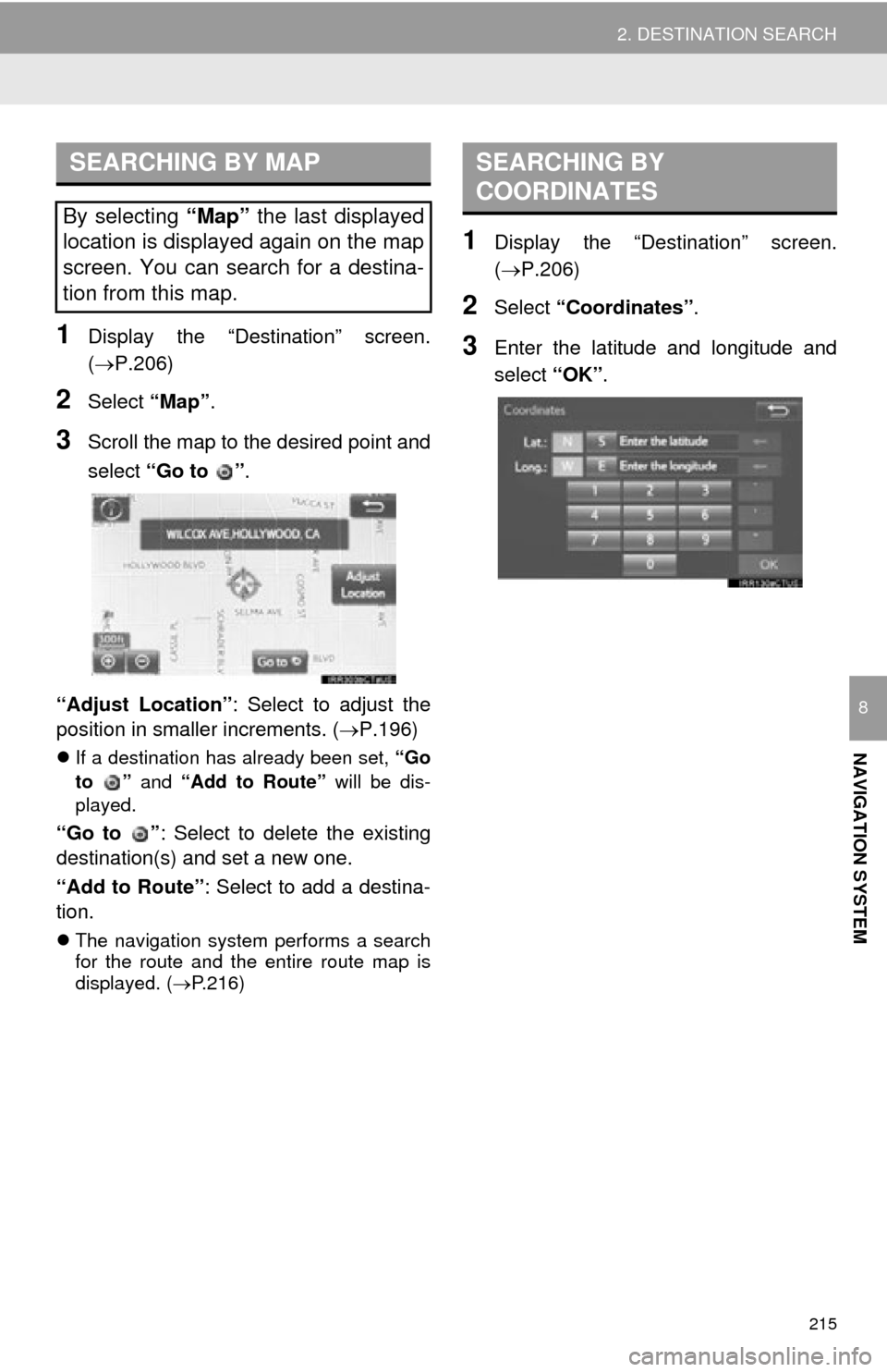
3Scroll the map to the desired point and
select “Go to ” .
“Adjust Location” : Select to adjust the
position in smaller increments. ( P.196)
If a destination has already been set, “Go
to ” and “Add to Route” will be dis-
played.
“Go to ” : Select to delete the existing
destination(s) and set a new one.
“Add to Route” : Select to add a destina-
tion.
The navigation system performs a search
for the route and the entire route map is
displayed. ( P.216)
1Display the “Destination” screen.
(P.206)
2Select “Coordinates” .
3Enter the latitude and longitude and
select “OK”.
SEARCHING BY MAP
By selecting “Map” the last displayed
location is displayed again on the map
screen. You can search for a destina-
tion from this map.
SEARCHING BY
COORDINATES
Page 215 of 285
216
2. DESTINATION SEARCH
3. STARTING ROUTE GUIDANCE
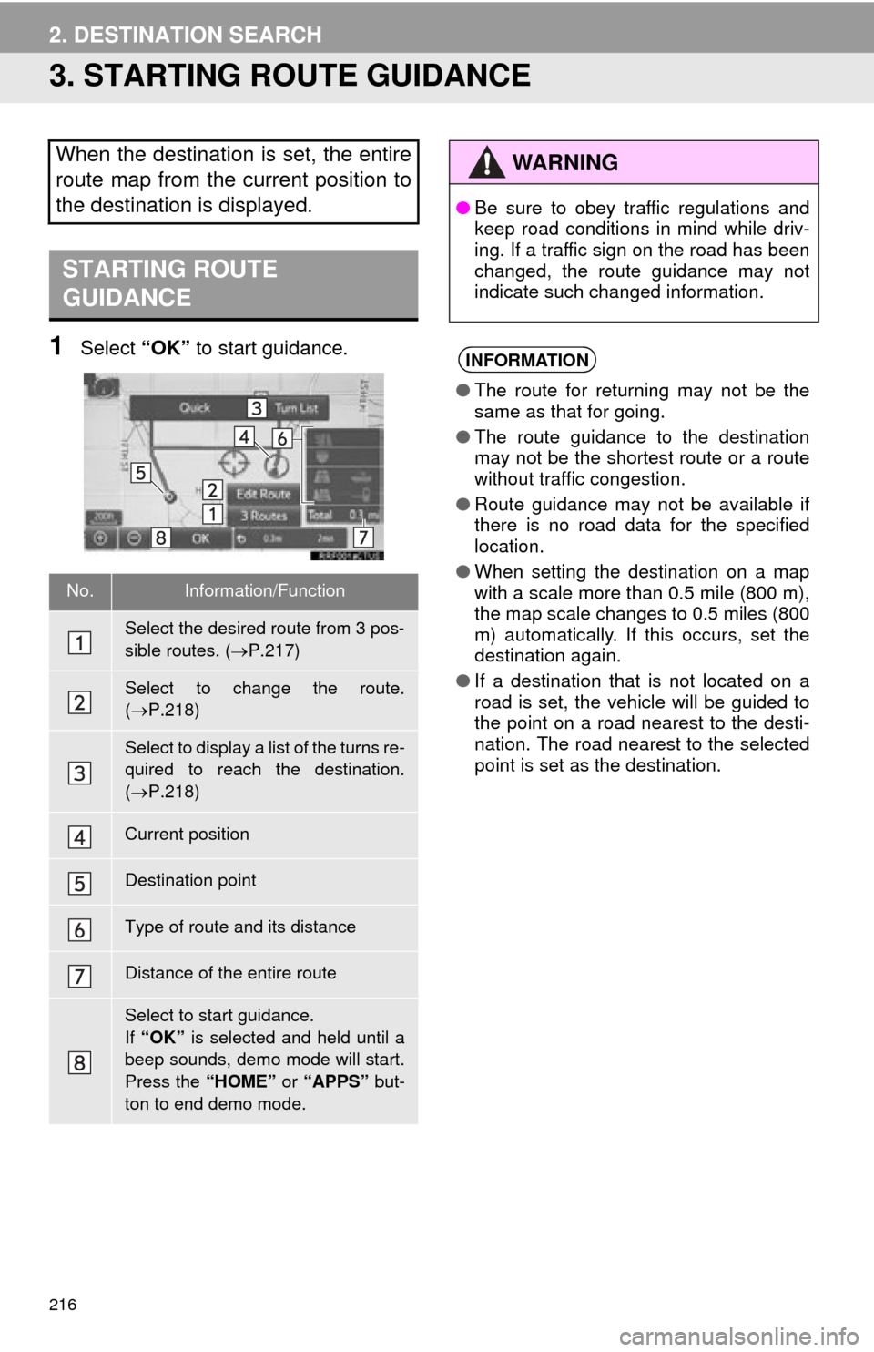
1Select “OK” to start guidance.
When the destination is set, the entire
route map from the current position to
the destination is displayed.
STARTING ROUTE
GUIDANCE
No.Information/Function
Select the desired route from 3 pos-
sible routes. ( P.217)
Select to change the route.
( P.218)
Select to display a list of the turns re-
quired to reach the destination.
( P.218)
Current position
Destination point
Type of route and its distance
Distance of the entire route
Select to start guidance.
If “OK” is selected and held until a
beep sounds, demo mode will start.
Press the “HOME” or “APPS” but-
ton to end demo mode.
WA R N I N G
● Be sure to obey traffic regulations and
keep road conditions in mind while driv-
ing. If a traffic sign on the road has been
changed, the route guidance may not
indicate such changed information.
INFORMATION
●The route for returning may not be the
same as that for going.
● The route guidance to the destination
may not be the shortest route or a route
without traffic congestion.
● Route guidance may not be available if
there is no road data for the specified
location.
● When setting the destination on a map
with a scale more than 0.5 mile (800 m),
the map scale changes to 0.5 miles (800
m) automatically. If this occurs, set the
destination again.
● If a destination that is not located on a
road is set, the vehicle will be guided to
the point on a road nearest to the desti-
nation. The road nearest to the selected
point is set as the destination.
Page 216 of 285
217
2. DESTINATION SEARCH
NAVIGATION SYSTEM
8
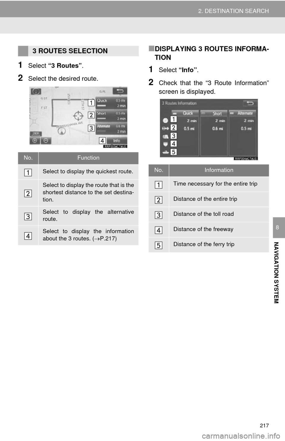
1Select “3 Routes” .
2Select the desired route.
■DISPLAYING 3 ROUTES INFORMA-
TION
1Select “Info”.
2Check that the “3 Route Information”
screen is displayed.
3 ROUTES SELECTION
No.Function
Select to display the quickest route.
Select to display the route that is the
shortest distance to the set destina-
tion.
Select to display the alternative
route.
Select to display the information
about the 3 routes. ( P.217)
No.Information
Time necessary for the entire trip
Distance of the entire trip
Distance of the toll road
Distance of the freeway
Distance of the ferry trip
Page 217 of 285
218
2. DESTINATION SEARCH
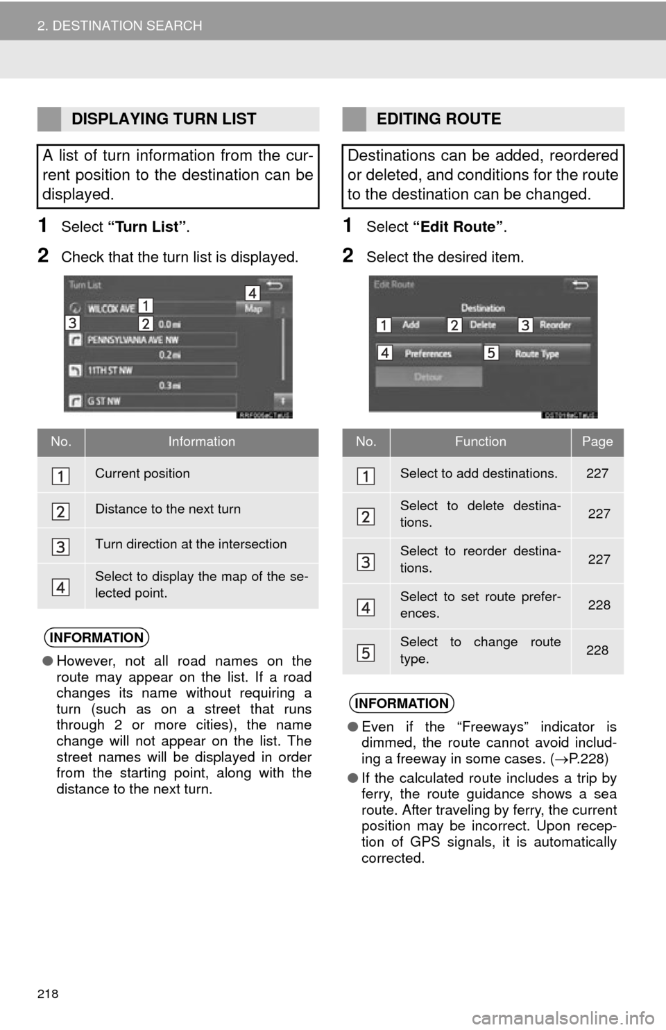
1Select “Turn List” .
2Check that the turn list is displayed.
1Select “Edit Route” .
2Select the desired item.
DISPLAYING TURN LIST
A list of turn information from the cur-
rent position to the destination can be
displayed.
No.Information
Current position
Distance to the next turn
Turn direction at the intersection
Select to display the map of the se-
lected point.
INFORMATION
● However, not all road names on the
route may appear on the list. If a road
changes its name without requiring a
turn (such as on a street that runs
through 2 or more cities), the name
change will not appear on the list. The
street names will be displayed in order
from the starting point, along with the
distance to the next turn.
EDITING ROUTE
Destinations can be added, reordered
or deleted, and conditions for the route
to the destination can be changed.
No.FunctionPage
Select to add destinations.227
Select to delete destina-
tions. 227
Select to reorder destina-
tions. 227
Select to set route prefer-
ences. 228
Select to change route
type.228
INFORMATION
● Even if the “Freeways” indicator is
dimmed, the route cannot avoid includ-
ing a freeway in some cases. ( P.228)
● If the calculated route includes a trip by
ferry, the route guidance shows a sea
route. After traveling by ferry, the current
position may be incorrect. Upon recep-
tion of GPS signals, it is automatically
corrected.
Page 218 of 285
219
2. DESTINATION SEARCH
NAVIGATION SYSTEM
8
1Select “Options” on the map screen.
2Select “Pause Guidance” .
1Select “Resume Guidance” .
PAUSING GUIDANCE
RESUMING GUIDANCE
Page 219 of 285
220
3. ROUTE GUIDANCE
1. ROUTE GUIDANCE SCREEN
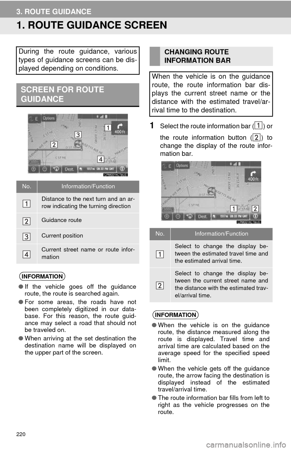
1Select the route information bar ( ) or
the route information button ( ) to
change the display of the route infor-
mation bar.
During the route guidance, various
types of guidance screens can be dis-
played depending on conditions.
SCREEN FOR ROUTE
GUIDANCE
No.Information/Function
Distance to the next turn and an ar-
row indicating the turning direction
Guidance route
Current position
Current street name or route infor-
mation
INFORMATION
●If the vehicle goes off the guidance
route, the route is searched again.
● For some areas, the roads have not
been completely digitized in our data-
base. For this reason, the route guid-
ance may select a road that should not
be traveled on.
● When arriving at the set destination the
destination name will be displayed on
the upper part of the screen.
CHANGING ROUTE
INFORMATION BAR
When the vehicle is on the guidance
route, the route information bar dis-
plays the current street name or the
distance with the estimated travel/ar-
rival time to the destination.
No.Information/Function
Select to change the display be-
tween the estimated travel time and
the estimated arrival time.
Select to change the display be-
tween the current street name and
the distance with the estimated trav-
el/arrival time.
INFORMATION
● When the vehicle is on the guidance
route, the distance measured along the
route is displayed. Travel time and
arrival time are calculated based on the
average speed for the specified speed
limit.
● When the vehicle gets off the guidance
route, the arrow facing the destination is
displayed instead of the estimated
travel/arrival time.
● The route information bar fills from left to
right as the vehicle progresses on the
route.
Page 220 of 285
221
3. ROUTE GUIDANCE
NAVIGATION SYSTEM
8
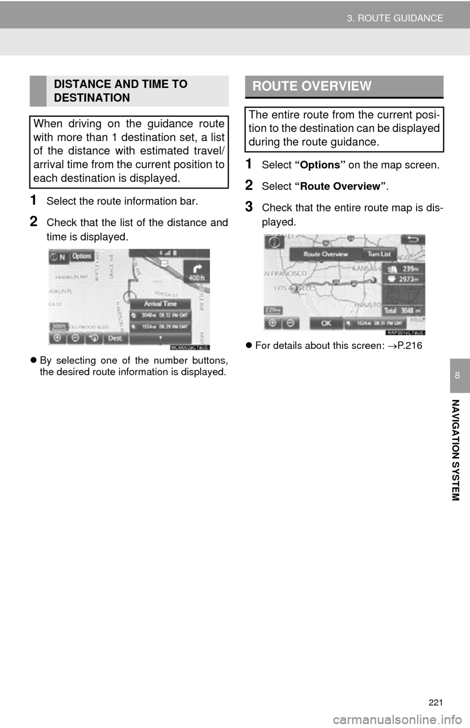
1Select the route information bar.
2Check that the list of the distance and
time is displayed.
By selecting one of the number buttons,
the desired route information is displayed.
1Select “Options” on the map screen.
2Select “Route Overview” .
3Check that the entire route map is dis-
played.
For details about this screen: P.216
DISTANCE AND TIME TO
DESTINATION
When driving on the guidance route
with more than 1 destination set, a list
of the distance with estimated travel/
arrival time from the current position to
each destination is displayed.ROUTE OVERVIEW
The entire route from the current posi-
tion to the destination can be displayed
during the route guidance.