navigation TOYOTA SEQUOIA 2013 2.G Navigation Manual
[x] Cancel search | Manufacturer: TOYOTA, Model Year: 2013, Model line: SEQUOIA, Model: TOYOTA SEQUOIA 2013 2.GPages: 328, PDF Size: 8.3 MB
Page 64 of 328
64
1. DESTINATION SEARCH
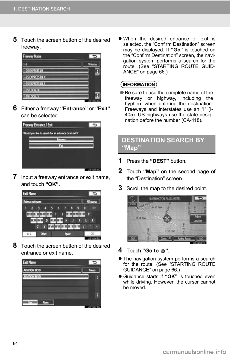
5Touch the screen button of the desired
freeway.
6Either a freeway “Entrance” or “Exit”
can be selected.
7Input a freeway entran ce or exit name,
and touch “OK”.
8Touch the screen button of the desired
entrance or exit name.
When the desired entrance or exit is
selected, the “Confirm Destination” screen
may be displayed. If “Go” is touched on
the “Confirm Destination” screen, the navi-
gation system performs a search for the
route. (See “STARTING ROUTE GUID-
ANCE” on page 66.)
1Press the “DEST” button.
2Touch “Map” on the second page of
the “Destination” screen.
3Scroll the map to the desired point.
4Touch “Go to ” .
The navigation system performs a search
for the route. (See “STARTING ROUTE
GUIDANCE” on page 66.)
Guidance starts if “OK” is touched even
while driving. However, the cursor cannot
be moved.
INFORMATION
● Be sure to use the complete name of the
freeway or highway, including the
hyphen, when entering the destination.
Freeways and interstates use an “I” (I-
405). US highways use the state desig-
nation before the number (CA-118).
DESTINATION SEARCH BY
“Map”
Page 65 of 328
65
1. DESTINATION SEARCH
3
NAVIGATION SYSTEM
1Press the “DEST” button.
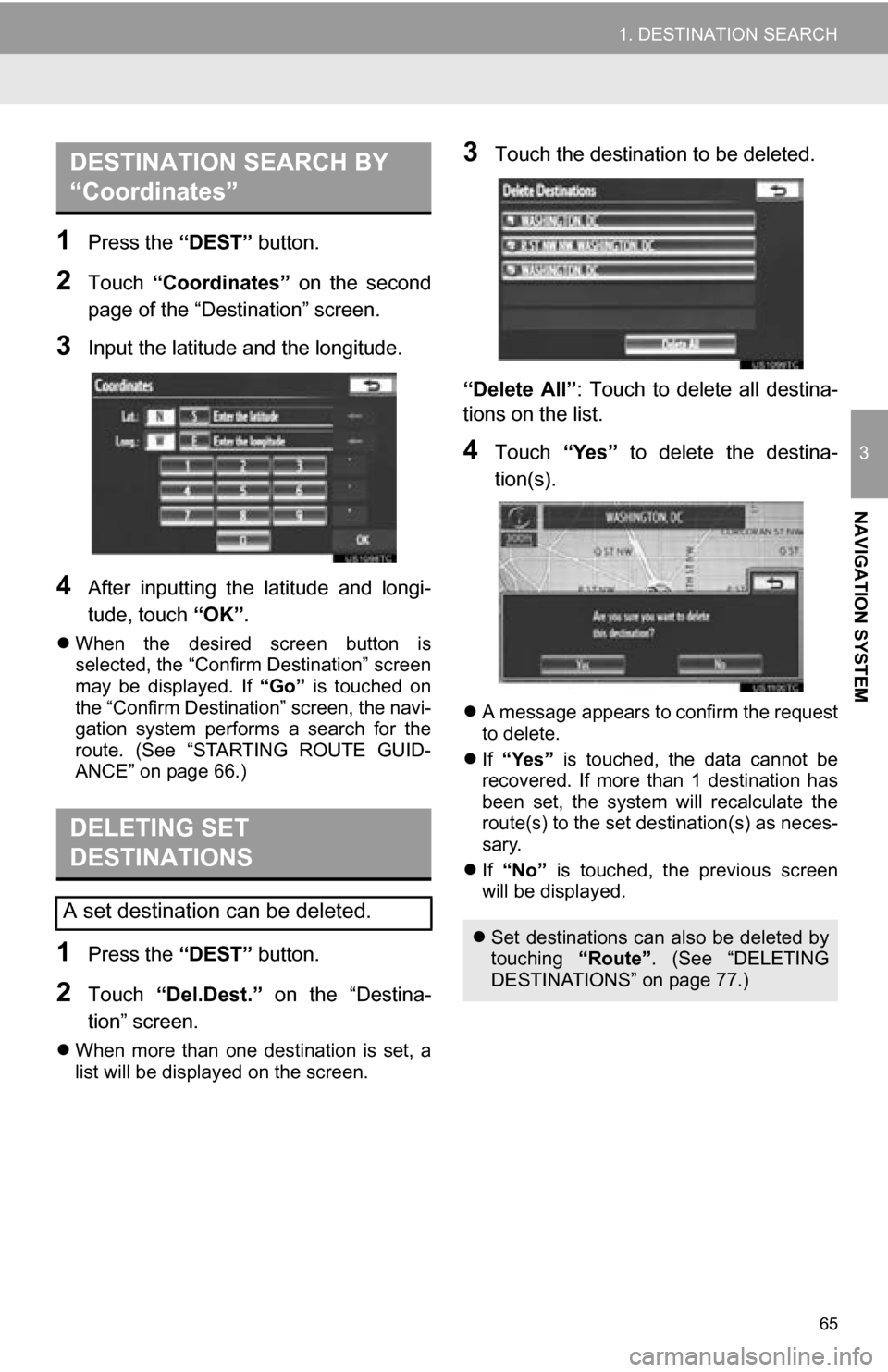
2Touch “Coordinates” on the second
page of the “Destination” screen.
3Input the latitude and the longitude.
4After inputting the latitude and longi-
tude, touch “OK”.
When the desired screen button is
selected, the “Confirm Destination” screen
may be displayed. If “Go” is touched on
the “Confirm Destination” screen, the navi-
gation system performs a search for the
route. (See “STARTING ROUTE GUID-
ANCE” on page 66.)
1Press the “DEST” button.
2Touch “Del.Dest.” on the “Destina-
tion” screen.
When more than one destination is set, a
list will be displayed on the screen.
3Touch the destination to be deleted.
“Delete All” : Touch to delete all destina-
tions on the list.
4Touch “Yes” to delete the destina-
tion(s).
A message appears to confirm the request
to delete.
If “Yes” is touched, the data cannot be
recovered. If more than 1 destination has
been set, the system will recalculate the
route(s) to the set destination(s) as neces-
sary.
If “No” is touched, the previous screen
will be displayed.
DESTINATION SEARCH BY
“Coordinates”
DELETING SET
DESTINATIONS
A set destination can be deleted.
Set destinations can also be deleted by
touching “Route”. (See “DELETING
DESTINATIONS” on page 77.)
Page 67 of 328
67
1. DESTINATION SEARCH
3
NAVIGATION SYSTEM
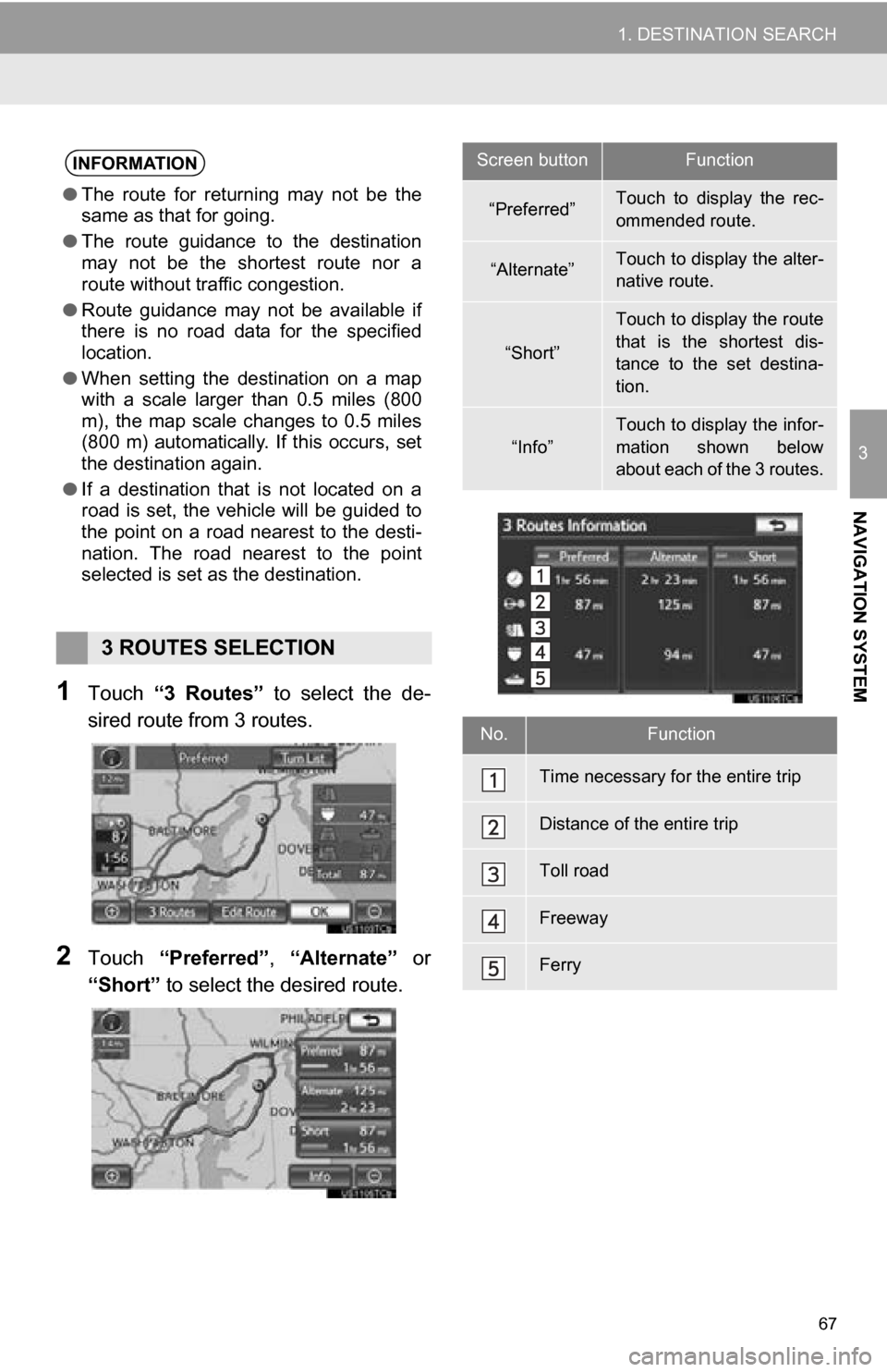
1Touch “3 Routes” to select the de-
sired route from 3 routes.
2Touch “Preferred”, “Alternate” or
“Short” to select the desired route.
INFORMATION
●The route for returning may not be the
same as that for going.
● The route guidance to the destination
may not be the shortest route nor a
route without traffic congestion.
● Route guidance may not be available if
there is no road data for the specified
location.
● When setting the destination on a map
with a scale larger than 0.5 miles (800
m), the map scale changes to 0.5 miles
(800 m) automatically. If this occurs, set
the destination again.
● If a destination that is not located on a
road is set, the vehicle will be guided to
the point on a road nearest to the desti-
nation. The road nearest to the point
selected is set as the destination.
3 ROUTES SELECTION
Screen buttonFunction
“Preferred”Touch to display the rec-
ommended route.
“Alternate”Touch to display the alter-
native route.
“Short”
Touch to display the route
that is the shortest dis-
tance to the set destina-
tion.
“Info”
Touch to display the infor-
mation shown below
about each of the 3 routes.
No.Function
Time necessary for the entire trip
Distance of the entire trip
Toll road
Freeway
Ferry
Page 69 of 328
69
3
NAVIGATION SYSTEM
2. ROUTE GUIDANCE
1. ROUTE GUIDANCE SCREEN
During route guidance, various types
of guidance screens can be displayed
depending on conditions.
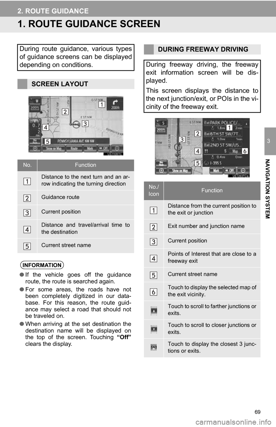
SCREEN LAYOUT
No.Function
Distance to the next turn and an ar-
row indicating the turning direction
Guidance route
Current position
Distance and travel/arrival time to
the destination
Current street name
INFORMATION
●If the vehicle goes off the guidance
route, the route is searched again.
● For some areas, the roads have not
been completely digitized in our data-
base. For this reason, the route guid-
ance may select a road that should not
be traveled on.
● When arriving at the set destination the
destination name will be displayed on
the top of the screen. Touching “Off”
clears the display.
DURING FREEWAY DRIVING
During freeway driving, the freeway
exit information screen will be dis-
played.
This screen displays the distance to
the next junction/exit, or POIs in the vi-
cinity of the freeway exit.
No./
IconFunction
Distance from the current position to
the exit or junction
Exit number and junction name
Current position
Points of Interest that are close to a
freeway exit
Current street name
Touch to display the selected map of
the exit vicinity.
Touch to scroll to farther junctions or
exits.
Touch to scroll to closer junctions or
exits.
Touch to display the closest 3 junc-
tions or exits.
Page 71 of 328
71
2. ROUTE GUIDANCE
3
NAVIGATION SYSTEM
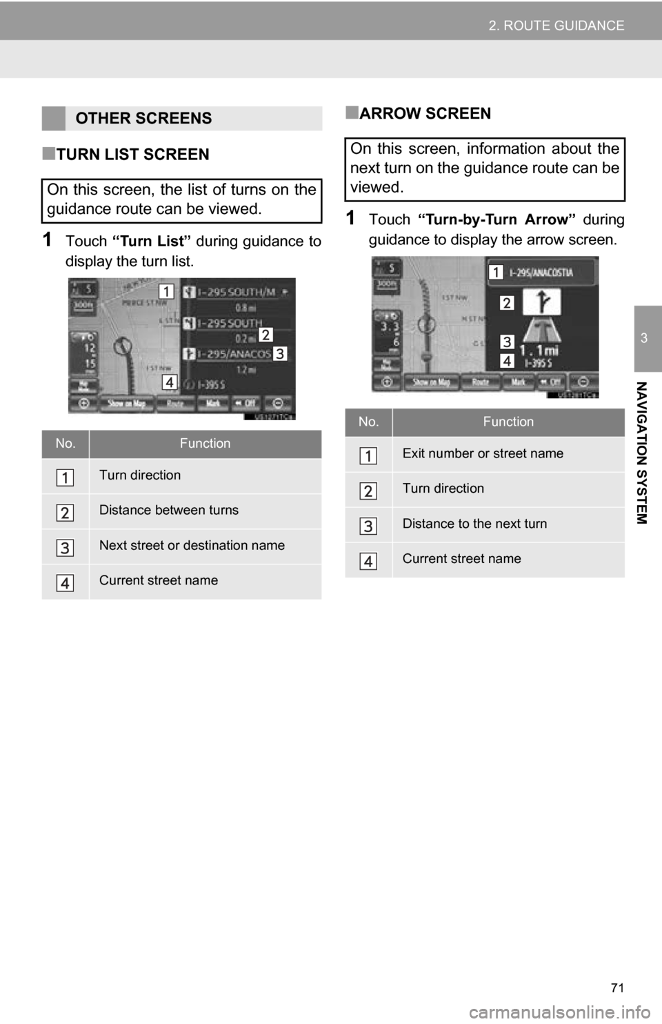
■TURN LIST SCREEN
1Touch “Turn List” during guidance to
display the turn list.
■ARROW SCREEN
1Touch “Turn-by-Turn Arrow” during
guidance to display the arrow screen.
OTHER SCREENS
On this screen, the list of turns on the
guidance route can be viewed.
No.Function
Turn direction
Distance between turns
Next street or destination name
Current street name
On this screen, information about the
next turn on the guidance route can be
viewed.
No.Function
Exit number or street name
Turn direction
Distance to the next turn
Current street name
Page 73 of 328
73
2. ROUTE GUIDANCE
3
NAVIGATION SYSTEM
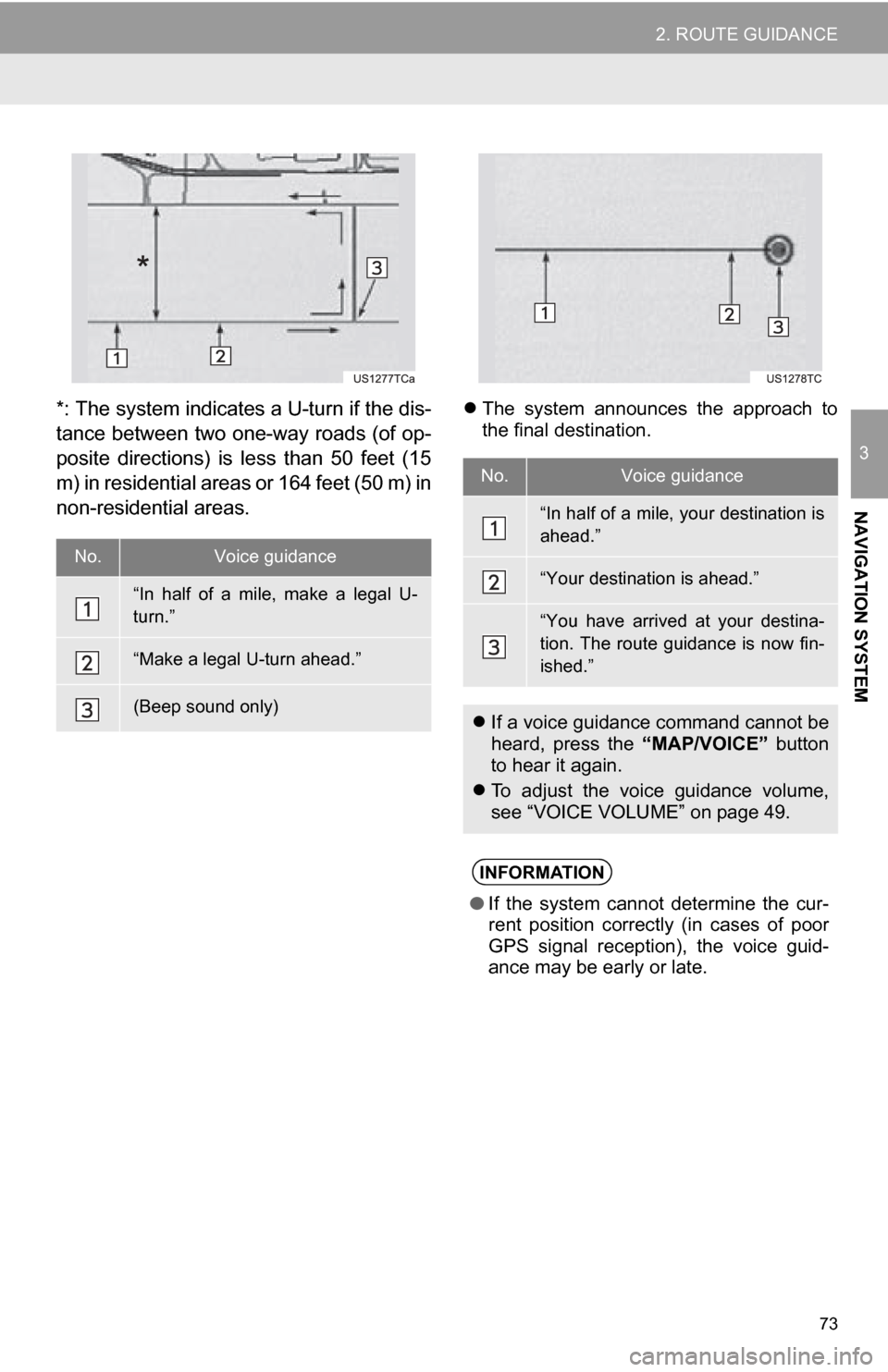
*: The system indicates a U-turn if the dis-
tance between two one-way roads (of op-
posite directions) is less than 50 feet (15
m) in residential areas or 164 feet (50 m) in
non-residential areas. The system announces the approach to
the final destination.
No.Voice guidance
“In half of a mile, make a legal U-
turn.”
“Make a legal U-turn ahead.”
(Beep sound only)
No.Voice guidance
“In half of a mile, your destination is
ahead.”
“Your destination is ahead.”
“You have arrived at your destina-
tion. The route guidance is now fin-
ished.”
If a voice guidance command cannot be
heard, press the “MAP/VOICE” button
to hear it again.
To adjust the voice guidance volume,
see “VOICE VOLUME” on page 49.
INFORMATION
●If the system cannot determine the cur-
rent position correctly (in cases of poor
GPS signal reception), the voice guid-
ance may be early or late.
Page 74 of 328
74
2. ROUTE GUIDANCE
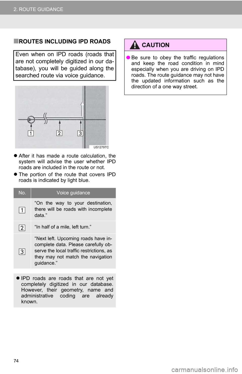
■ROUTES INCLUDING IPD ROADS
After it has made a route calculation, the
system will advise the user whether IPD
roads are included in the route or not.
The portion of the route that covers IPD
roads is indicated by light blue.
Even when on IPD roads (roads that
are not completely digitized in our da-
tabase), you will be guided along the
searched route via voice guidance.
No.Voice guidance
“On the way to your destination,
there will be roads with incomplete
data.”
“In half of a mile, left turn.”
“Next left. Upcoming roads have in-
complete data. Please carefully ob-
serve the local traffic restrictions, as
they may not match the navigation
guidance.”
IPD roads are roads that are not yet
completely digitized in our database.
However, their geometry, name and
administrative coding are already
known.
CAUTION
●Be sure to obey the traffic regulations
and keep the road condition in mind
especially when you are driving on IPD
roads. The route guidance may not have
the updated information such as the
direction of a one way street.
Page 75 of 328
75
2. ROUTE GUIDANCE
3
NAVIGATION SYSTEM
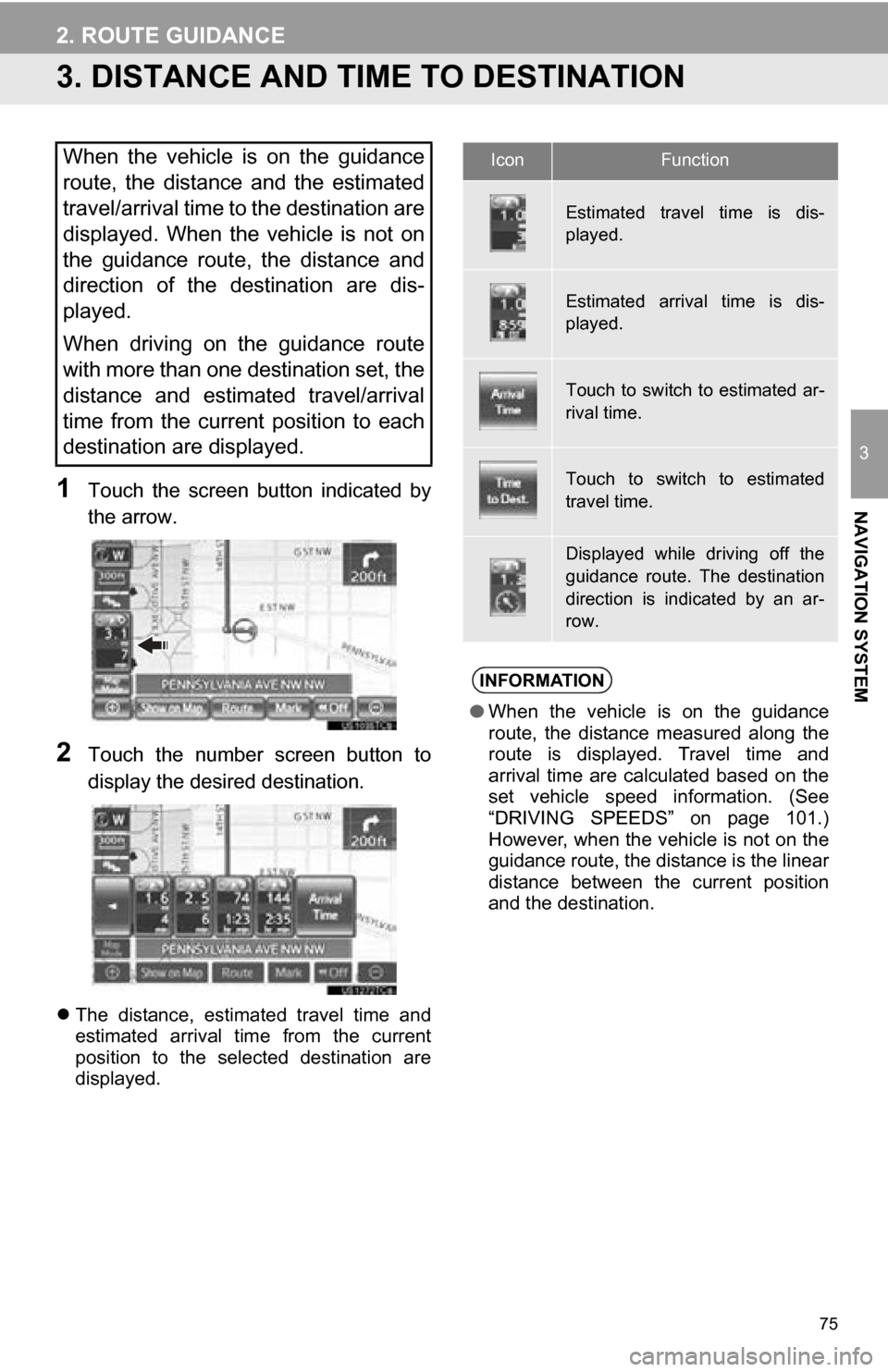
3. DISTANCE AND TIME TO DESTINATION
1Touch the screen button indicated by
the arrow.
2Touch the number screen button to
display the desired destination.
The distance, estimated travel time and
estimated arrival time from the current
position to the selected destination are
displayed.
When the vehicle is on the guidance
route, the distance and the estimated
travel/arrival time to the destination are
displayed. When the vehicle is not on
the guidance route, the distance and
direction of the destination are dis-
played.
When driving on the guidance route
with more than one destination set, the
distance and estimated travel/arrival
time from the current position to each
destination are displayed.IconFunction
Estimated travel time is dis-
played.
Estimated arrival time is dis-
played.
Touch to switch to estimated ar-
rival time.
Touch to switch to estimated
travel time.
Displayed while driving off the
guidance route. The destination
direction is indicated by an ar-
row.
INFORMATION
●When the vehicle is on the guidance
route, the distance measured along the
route is displayed. Travel time and
arrival time are calculated based on the
set vehicle speed information. (See
“DRIVING SPEEDS” on page 101.)
However, when the vehicle is not on the
guidance route, the distance is the linear
distance between the current position
and the destination.
Page 77 of 328
77
2. ROUTE GUIDANCE
3
NAVIGATION SYSTEM
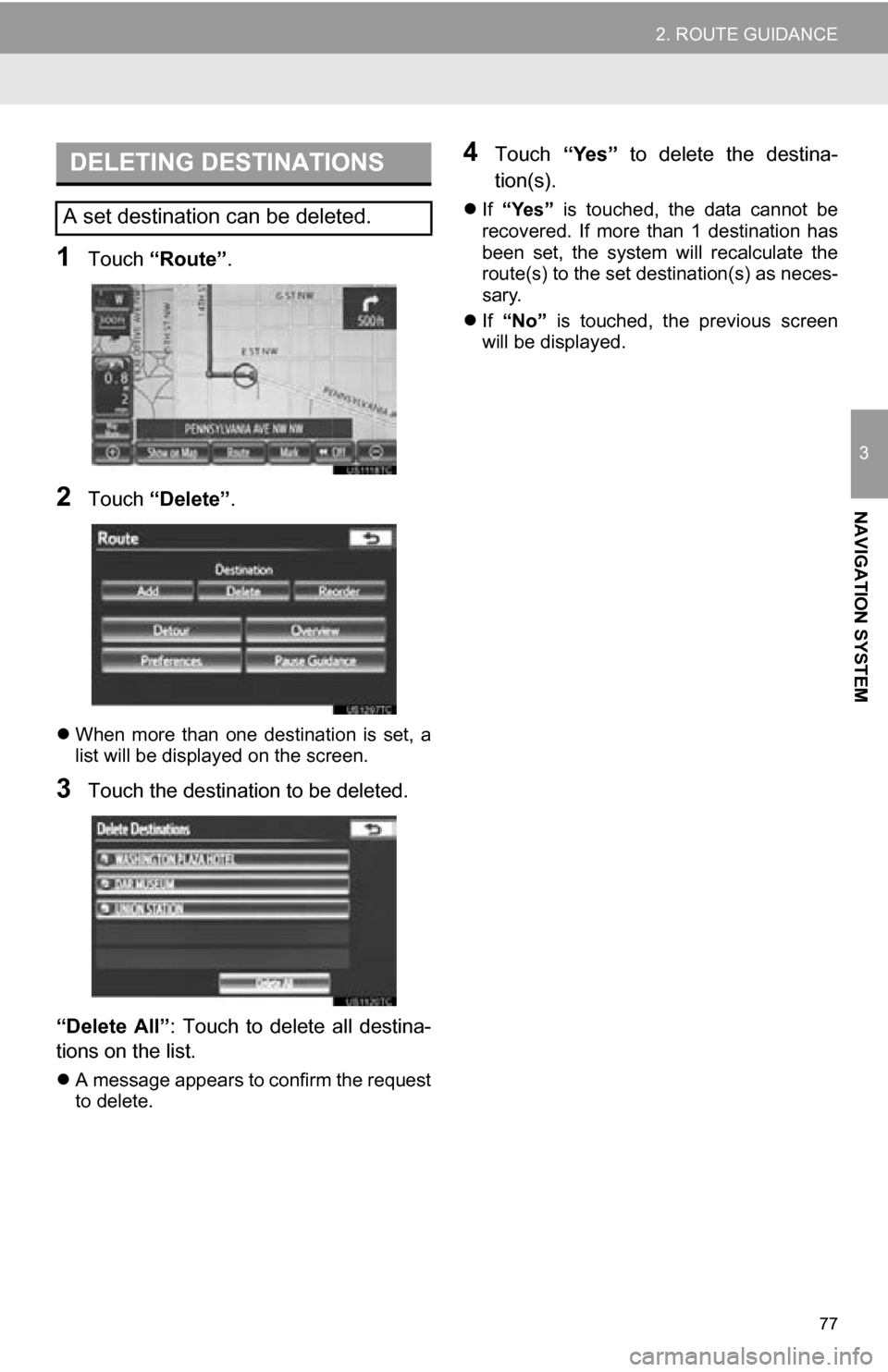
1Touch “Route” .
2Touch “Delete” .
When more than one destination is set, a
list will be displayed on the screen.
3Touch the destination to be deleted.
“Delete All”: Touch to delete all destina-
tions on the list.
A message appears to confirm the request
to delete.
4Touch “Yes” to delete the destina-
tion(s).
If “Yes” is touched, the data cannot be
recovered. If more than 1 destination has
been set, the system will recalculate the
route(s) to the set destination(s) as neces-
sary.
If “No” is touched, the previous screen
will be displayed.
DELETING DESTINATIONS
A set destination can be deleted.
Page 79 of 328
79
2. ROUTE GUIDANCE
3
NAVIGATION SYSTEM
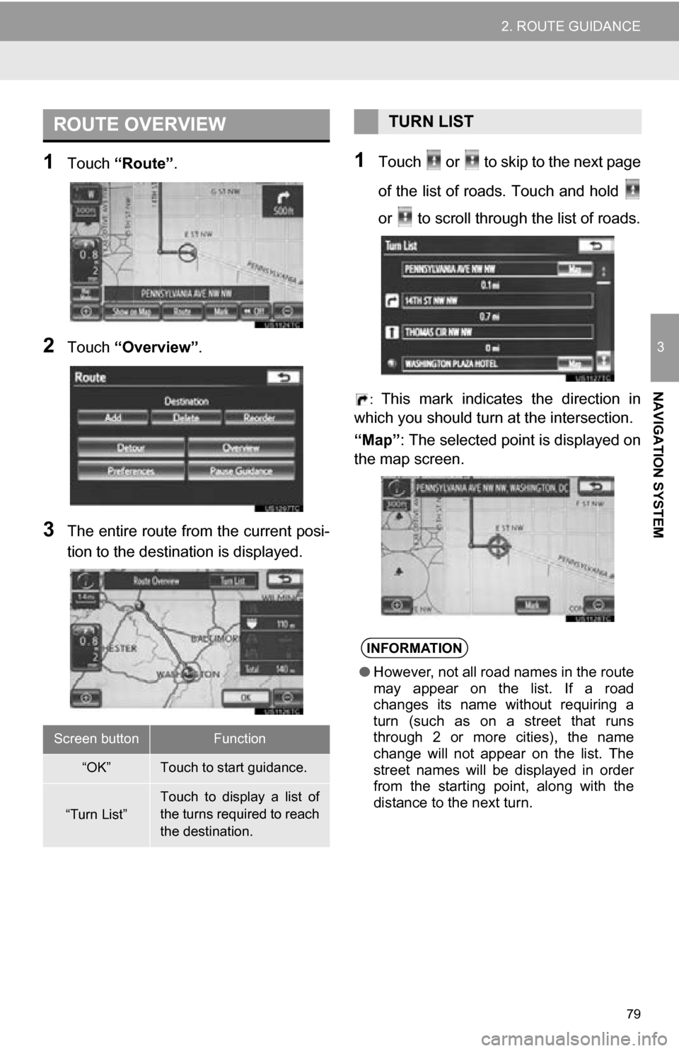
1Touch “Route” .
2Touch “Overview” .
3The entire route from the current posi-
tion to the destination is displayed.
1Touch or to skip to the next page
of the list of roads. Touch and hold
or to scroll through the list of roads.
: This mark indicates the direction in
which you should turn at the intersection.
“Map”: The selected point is displayed on
the map screen.
ROUTE OVERVIEW
Screen buttonFunction
“OK”Touch to start guidance.
“Turn List”
Touch to display a list of
the turns required to reach
the destination.
TURN LIST
INFORMATION
● However, not all road names in the route
may appear on the list. If a road
changes its name without requiring a
turn (such as on a street that runs
through 2 or more cities), the name
change will not appear on the list. The
street names will be displayed in order
from the starting point, along with the
distance to the next turn.