Acura CSX 2011 Navigation Manual
Manufacturer: ACURA, Model Year: 2011, Model line: CSX, Model: Acura CSX 2011Pages: 145, PDF Size: 4.11 MB
Page 101 of 145

Navigation System
Database Limitations
• Weather conditions
• Special events
• Pavement characteristics or
conditions
• Traffic congestion
• Travel time
We assume no liability for any incident
that may result from an error in the
program, or from changed conditions
not noted above.
Copyrights• infoUSA-Data: Certain business data
provided by infoUSA, Inc., Omaha,
Nebraska, Copyright © 2009, All
Rights Reserved.
• EXIT-Data: © ZENRIN CO., LTD.
2009. All Rights Reserved.
101
Page 102 of 145

Navigation System
Client AssistanceReporting ErrorsOccasionally, you may encounter
database errors.
For errors pertaining to:
• Highways and main verified roads
shown in black on the map
• Missing or wrong address location
Report it to:
http://update.navteq.com/
For any other questions or concerns,
contact Acura Client Services.
• Keep in mind that depending on when
the data was collected and when your
DVD was purchased, the database
can be out of date. Updates are
available for purchase, usually in the
fall of each year.• If the error does not involve the
database, such as vehicle position
icon errors, screen error messages, or
other GPS-related errors, refer to the
Frequently Asked Questions on
page 117, System Limitations on
page 98, or Troubleshooting on
page 126.
Acura Automobile Client
ServicesTelephone: 1-888-9-ACURA-9
Hours: 8:00 am to 7:30 pm Monday to
Friday (Eastern time)
Mail:
Acura Navi
Honda Canada Inc.
Acura Client Services
180 Honda Boulevard
Markham, ON
L6C 0H9
E-mail: [email protected]
102
Page 103 of 145

Navigation SystemClient Assistance
Visiting Your DealerWe strive to make this manual as
complete as possible and to answer all
questions regarding operation of the
system. Occasionally, you may run into
a specific issue that you cannot find in
the book. You may save yourself a trip
to the dealer by first consulting the
following resources:
• The Troubleshooting section (see
page 126).
• The Frequently Asked Questions
(FAQs) section (see page 117).
• For detailed questions regarding
audio or other systems that interact
with the navigation system, see your
Owner’s Manual or the Advanced
Technology Guide.
• Call Acura Client Services (see
“Acura Automobile Client Services”
on page 102).
• For database or POI issues, follow the
guidelines in the “Reporting Errors”
section (see page 102).If your question is still unanswered and
you wish to visit the dealer, please be
prepared to demonstrate the issue to the
service consultant. That way, the service
consultant can document the issue for
the factory to allow more efficient
troubleshooting.
Some issues may at first seem random,
but you may notice a pattern. For
example, they only occur when you
enter a specific address, or when driving
on a certain road, or just when it’s cold.
This information is very useful to the
service consultant. Be patient, the
service consultant may be unfamiliar
with your specific issue.
Obtaining a Navigation
Update DVDAcura is continually expanding the
scope of the navigation system.
Upgraded software with improved
mapping will be made available for
purchase periodically, usually in the fall
of each year.
To purchase an updated DVD or a
replacement DVD, order online at
www.acuranavi.ca.
NOTE:
• DVDs are not available at your
dealer. However, the dealer may
order a DVD for you as a courtesy.
There is no program for free DVD
updates.
• The DVD order line staff cannot
answer technical questions regarding
navigation operation, coverage, or
POIs.
• Purchasing used discs from alternate
sources or online auctions may cause
operational problems since they are
likely to be incompatible with your
current software.
103
Page 104 of 145
Navigation System
Client AssistanceChanging the DVDNOTE:
The system’s database is stored on a
removable DVD. The system will not
work without the DVD. Ensure the door
remains closed at all times.
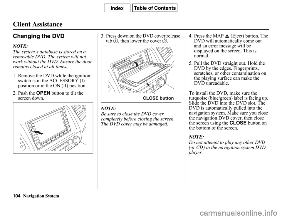
1. Remove the DVD while the ignition
switch is in the ACCESSORY (I)
position or in the ON (II) position.
2. Push the OPEN button to tilt the
screen down.3. Press down on the DVD cover release
tab , then lower the cover .
NOTE:
Be sure to close the DVD cover
completely before closing the screen.
The DVD cover may be damaged.4. Press the MAP (Eject) button. The
DVD will automatically come out
and an error message will be
displayed on the screen. This is
normal.
5. Pull the DVD straight out. Hold the
DVD by the edges. Fingerprints,
scratches, or other contamination on
the playing surface can make the
DVD unreadable.
To install the DVD, make sure the
turquoise (blue/green) label is facing up.
Slide the DVD into the DVD slot. The
DVD is automatically pulled into the
navigation system. Make sure you close
the navigation DVD cover, then close
the screen using the CLOSE button on
the bottom of the screen.
NOTE:
Do not attempt to play any other DVD
(or CD) in the navigation system DVD
player.
CLOSE button
104
Page 105 of 145
Navigation System105Client Assistance
PC Card OperationA PC card with WMA or MP3 audio
files can be played through the audio
system and controlled using the
navigation voice control system. PC
card (PCMCIA) adaptors and various
media chips can be purchased at any
computer store. Tested media chips
include Compact Flash and SD media,
up to 2GB. Other media types and
storage capacities may work, but have
not been tested. Hard disc drive type
media are not recommended because
they can fail in a hot vehicle. See the
FAQs section for additional
information.
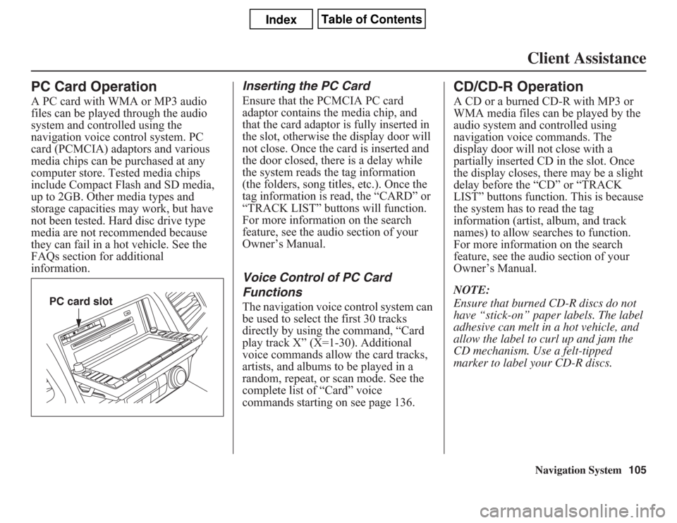
Inserting the PC CardEnsure that the PCMCIA PC card
adaptor contains the media chip, and
that the card adaptor is fully inserted in
the slot, otherwise the display door will
not close. Once the card is inserted and
the door closed, there is a delay while
the system reads the tag information
(the folders, song titles, etc.). Once the
tag information is read, the “CARD” or
“TRACK LIST” buttons will function.
For more information on the search
feature, see the audio section of your
Owner’s Manual.Voice Control of PC Card
FunctionsThe navigation voice control system can
be used to select the first 30 tracks
directly by using the command, “Card
play track X” (X=1-30). Additional
voice commands allow the card tracks,
artists, and albums to be played in a
random, repeat, or scan mode. See the
complete list of “Card” voice
commands starting on see page 136.
CD/CD-R OperationA CD or a burned CD-R with MP3 or
WMA media files can be played by the
audio system and controlled using
navigation voice commands. The
display door will not close with a
partially inserted CD in the slot. Once
the display closes, there may be a slight
delay before the “CD” or “TRACK
LIST” buttons function. This is because
the system has to read the tag
information (artist, album, and track
names) to allow searches to function.
For more information on the search
feature, see the audio section of your
Owner’s Manual.
NOTE:
Ensure that burned CD-R discs do not
have “stick-on” paper labels. The label
adhesive can melt in a hot vehicle, and
allow the label to curl up and jam the
CD mechanism. Use a felt-tipped
marker to label your CD-R discs.
PC card slot
Page 106 of 145
106
Navigation System
Client AssistanceVoice Control of CD FunctionsThe navigation voice control system can
be used to select the first 30 tracks
directly by using the command, “CD
play track X” (X=1-30). Additional
voice commands allow CD tracks, and
folders be played in a random, repeat, or
scan mode. See the complete list of
“CD” voice commands starting on
page 136.
Page 107 of 145
Navigation System107Coverage Areas
Map CoverageThe system discs installed at the factory
provide map coverage for the lower 48
U.S. states and Canada. The U.S. map
coverage consists of accurately mapped
(verified) metropolitan areas (in the
following list) and a less accurate
(unverified) rural database. Canada
coverage consists of major metropolitan
areas and major roads connecting the
metropolitan areas. When travelling to
U.S. destinations not included in the
Canada DVD, you will need to use both
the Canada and United States DVDs to
travel to your final destination.
The cities and metropolitan areas in the
following list are fully mapped. Only
major streets, roads, and highways have
been verified outside these areas. If your
route passes through these areas, routing
may be limited, depending on your
routing choices (see Unverified Area
Routing on page 83).
U.S. Detailed Coverage AreasNOTE:
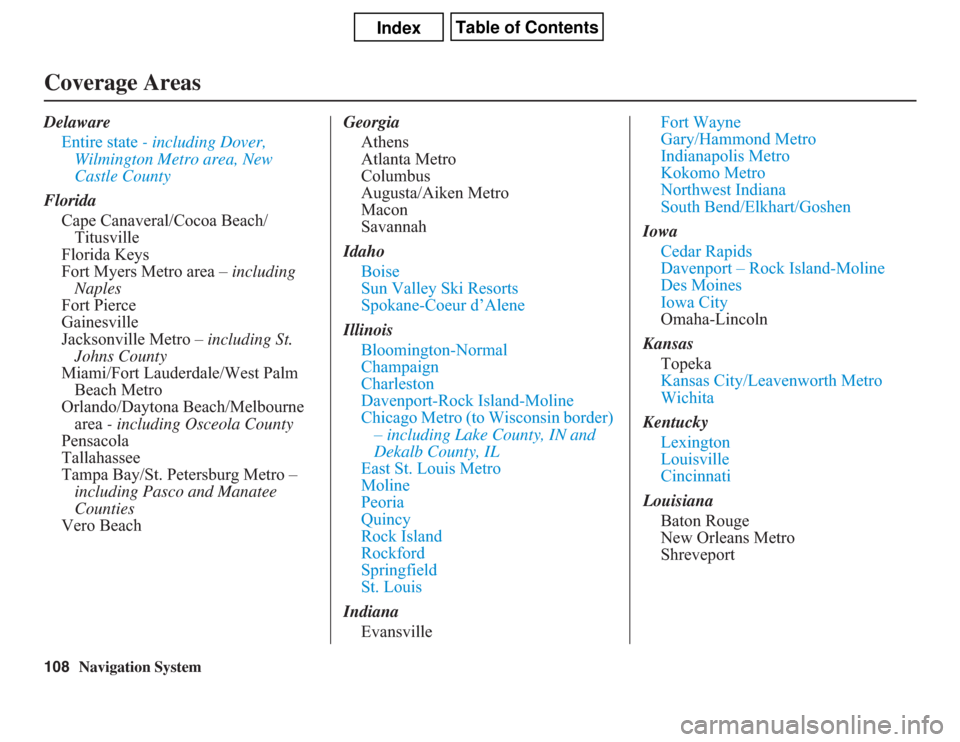
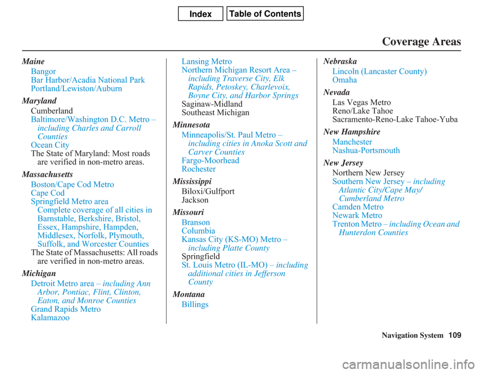
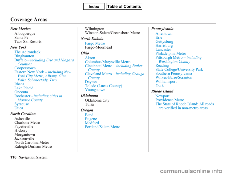
The blue city names are included in the
Canada DVD. To obtain coverage for
cities listed in black, please insert the
United States DVD. In order to plot a
route to some of these destinations you
may be required to use both the Canada
and United States DVDs. DVDs are not
available at your dealer.
Alabama
Birmingham/Tuscaloosa
Huntsville
Mobile
Montgomery
Arizona
Phoenix Metro
Sedona
Tucson
Arkansas
Fayetteville
Hot Springs
Little RockCalifornia
Bakersfield
Fresno
Los Angeles/San Diego Metro
Merced
Modesto
Sacramento Metro
Sacramento-Reno-Lake Tahoe-Yuba
San Francisco Bay (approximately
Monterey to Sonoma) – including
Monterey County and Hollister
San Luis Obispo
Stockton
Southern California Area
Colorado
Denver/Boulder/Colorado Springs/
Ski Resorts Metro area - including
Ft. Collins
Grand Junction
Connecticut
Bridgeport
Danbury
Hartford Metro
New Haven Metro
Norwalk
Stamford
The State of Connecticut: All roads
are verified in non-metro areas.
Page 108 of 145
108
Navigation System
Coverage AreasDelaware
Entire state - including Dover,
Wilmington Metro area, New
Castle County
Florida
Cape Canaveral/Cocoa Beach/
Titusville
Florida Keys
Fort Myers Metro area – including
Naples
Fort Pierce
Gainesville
Jacksonville Metro – including St.
Johns County
Miami/Fort Lauderdale/West Palm
Beach Metro
Orlando/Daytona Beach/Melbourne
area - including Osceola County
Pensacola
Tallahassee
Tampa Bay/St. Petersburg Metro –
including Pasco and Manatee
Counties
Vero BeachGeorgia
Athens
Atlanta Metro
Columbus
Augusta/Aiken Metro
Macon
Savannah
Idaho
Boise
Sun Valley Ski Resorts
Spokane-Coeur d’Alene
Illinois
Bloomington-Normal
Champaign
Charleston
Davenport-Rock Island-Moline
Chicago Metro (to Wisconsin border)
– including Lake County, IN and
Dekalb County, IL
East St. Louis Metro
Moline
Peoria
Quincy
Rock Island
Rockford
Springfield
St. Louis
Indiana
EvansvilleFort Wayne
Gary/Hammond Metro
Indianapolis Metro
Kokomo Metro
Northwest Indiana
South Bend/Elkhart/Goshen
Iowa
Cedar Rapids
Davenport – Rock Island-Moline
Des Moines
Iowa City
Omaha-Lincoln
Kansas
Topeka
Kansas City/Leavenworth Metro
Wichita
Kentucky
Lexington
Louisville
Cincinnati
Louisiana
Baton Rouge
New Orleans Metro
Shreveport
Page 109 of 145
Navigation System109Coverage Areas
Maine
Bangor
Bar Harbor/Acadia National Park
Portland/Lewiston/Auburn
Maryland
Cumberland
Baltimore/Washington D.C. Metro –
including Charles and Carroll
Counties
Ocean City
The State of Maryland: Most roads
are verified in non-metro areas.
Massachusetts
Boston/Cape Cod Metro
Cape Cod
Springfield Metro area
Complete coverage of all cities in
Barnstable, Berkshire, Bristol,
Essex, Hampshire, Hampden,
Middlesex, Norfolk, Plymouth,
Suffolk, and Worcester Counties
The State of Massachusetts: All roads
are verified in non-metro areas.
Michigan
Detroit Metro area – including Ann
Arbor, Pontiac, Flint, Clinton,
Eaton, and Monroe Counties
Grand Rapids Metro
KalamazooLansing Metro
Northern Michigan Resort Area –
including Traverse City, Elk
Rapids, Petoskey, Charlevoix,
Boyne City, and Harbor Springs
Saginaw-Midland
Southeast Michigan
Minnesota
Minneapolis/St. Paul Metro –
including cities in Anoka Scott and
Carver Counties
Fargo-Moorhead
Rochester
Mississippi
Biloxi/Gulfport
Jackson
Missouri
Branson
Columbia
Kansas City (KS-MO) Metro –
including Platte County
Springfield
St. Louis Metro (IL-MO) – including
additional cities in Jefferson
County
Montana
BillingsNebraska
Lincoln (Lancaster County)
Omaha
Nevada
Las Vegas Metro
Reno/Lake Tahoe
Sacramento-Reno-Lake Tahoe-Yuba
New Hampshire
Manchester
Nashua-Portsmouth
New Jersey
Northern New Jersey
Southern New Jersey – including
Atlantic City/Cape May/
Cumberland Metro
Camden Metro
Newark Metro
Trenton Metro – including Ocean and
Hunterdon Counties
Page 110 of 145
110
Navigation System
Coverage AreasNew Mexico
Albuquerque
Santa Fe
Taos Ski Resorts
New York
The Adirondack
Binghamton
Buffalo – including Erie and Niagara
Counties
Cooperstown
Eastern New York – including New
York City Metro, Albany, Glen
Falls, Schenectady, Troy
Ithaca
Lake Placid
Oneonta
Rochester - including cities in
Monroe County
Syracuse
Utica
North Carolina
Asheville
Charlotte Metro
Fayetteville
Hickory
Morgantown
Jacksonville
North Carolina Metro
Raleigh-Durham MetroWilmington
Winston-Salem/Greensboro Metro
North Dakota
Fargo Metro
Fargo-Moorhead
Ohio
Akron
Columbus/Marysville Metro
Cincinnati Metro – including Butler
County
Cleveland Metro – including Geauga
County
Dayton
Toledo (Lucas County)
Youngstown
Oklahoma
Oklahoma City
Tulsa
Oregon
Bend
Eugene
Medford
Portland/Salem MetroPennsylvania
Allentown
Erie
Gettysburg
Harrisburg
Lancaster
Philadelphia Metro
Pittsburgh Metro – including
Washington County
Reading
State College/University Park
Southern Pennsylvania
Wilkes-Barre/Scranton
Williamsport
York
Rhode Island
Newport
Providence Metro
The State of Rhode Island: All roads
are verified in non-metro areas.