CITROEN DISPATCH SPACETOURER DAG 2017 Handbook (in English)
DISPATCH SPACETOURER DAG 2017
CITROEN
CITROEN
https://www.carmanualsonline.info/img/9/43536/w960_43536-0.png
CITROEN DISPATCH SPACETOURER DAG 2017 Handbook (in English)
Trending: tow bar, spare wheel, tow, towing capacity, manual radio set, warning light, change language
Page 361 of 774

359
Spacetourer-VP_en_Chap10b_NAC-1_ed01-2016
As a safety measure and because it
requires sustained attention by the
driver, using a smartphone when
driving is prohibited.
All operations must be done with the
vehicle stationary.
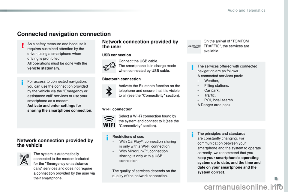
Connected navigation connection
The principles and standards
are constantly changing. For
communication between your
smartphone and the system to operate
correctly, we recommend that you
keep your smar tphone's operating
system up to date, and the time and
date on your smar tphone and the
system correct. The services offered with connected
navigation are as follows.
A connected services pack:
-
Weather,
-
F
illing stations,
-
C
ar park,
-
Tr a f f i c ,
-
P
OI, local search.
A Danger area pack.
Activate the Bluetooth function on the
telephone and ensure that it is visible
to all (see the "Connectivity" section). Connect the USB cable.
The smartphone is in charge mode
when connected by USB cable.
The system is automatically
connected to the modem included
for the "Emergency or assistance
calls" services and does not require
a connection provided by the user via
their smartphone. On the arrival of "TOMTOM
TR AFFIC", the services are
available.
For access to connected navigation,
you can use the connection provided
by the vehicle via the "Emergency or
assistance
call" services or use your
smartphone as a modem.
Activate and enter settings for
sharing the smartphone connection.
Restrictions of use:
-
W
ith CarPlay
®, connection sharing
is
only with a Wi-Fi connection.
-
W
ith MirrorLink
TM, connection
sharing is only with a USB
connection.
The quality of services depends on the
quality of the network connection. Select a Wi-Fi connection found by
the system and connect to it (see the
"Connectivity" section).
USB connection
Network connection provided by
the vehicle Network connection provided by
the user
Bluetooth connection
Wi-Fi connection
.
Audio and Telematics
Page 362 of 774
360
12:1323 °C
12:13
23 °C
1
12:13
23 °C
12:13
23 °C
7
2728262930
Spacetourer-VP_en_Chap10b_NAC-1_ed01-2016
Level 1 Level 2Level 3
Point of interest on map
Audio and Telematics
Page 363 of 774
361
7
28
27
26
29
30
Spacetourer-VP_en_Chap10b_NAC-1_ed01-2016
Level 1Level 2 Level 3 Comments
Navigation Select the orientation of the map; north up,
vehicle direction up or perspective.
Navigation
TOMTOM TR AFFIC On connection of the system to a network,
"TOMTOM TR AFFIC" is displayed instead of
"TMC", for use of all of the options available, in
real time.
Navigation Weather
Select the options.
The map display the route chosen, depending on
options.
Stations
Car park
Tr a f f i c
Danger area
Map color
Select the display mode for the map.
POI on map Commercial
Select the POIs available.
Geographic
Leisure
Public
Travel
Confirm
Save the options.
View map Modify citySelect or change a city.
Zoom out.
Zoom in.
.
Audio and Telematics
Page 364 of 774
362
3132
Spacetourer-VP_en_Chap10b_NAC-1_ed01-2016
Level 3Level 4Level 5
Filling stations located
Sort by spaces Weather information
Audio and Telematics
Page 365 of 774
363
31
32
Spacetourer-VP_en_Chap10b_NAC-1_ed01-2016
Level 3Level 4 Level 5 Comments
Select city Confirm Select or change a city.
Around the vehicle Select or change a city.
On the route
At the destination
Weather Weather informationDisplay the weather forecast for the day or the
following days.
Filling stations Filling stations around the vehicle
Display the list of filling stations and the
associated information (address, prices,
fuels,
...
).
Filling stations on the route
Filling stations at the destination
By distance
By price
Car park Car parks around the vehicle
Display the list of car parks and the associated
information (address, distance, spaces available,
price, ...).
Car parks on the route
Car parks at the destination
Sort by distance
Sort by spaces
Sort by price
Zoom out.
Zoom in.
.
Audio and Telematics
Page 366 of 774
364
Spacetourer-VP_en_Chap10b_NAC-1_ed01-2016
Level 3 Level 4 Level 5
Select POI
List of danger areas Traffic observed
Audio and Telematics
Page 367 of 774
365
Spacetourer-VP_en_Chap10b_NAC-1_ed01-2016
Level 3Level 4 Level 5 Comments
Tr a f f i c Traffic observedDisplay traffic information in real time: type,
description and duration (in minutes).
Danger areas List of danger areasDisplay danger areas (roadworks, breakdowns,
accidents, ...) in real time.
Points of interest Points of
interestSelect POI
Display the list of POIs for the location selected.
.
Audio and Telematics
Page 368 of 774

366
22
23
1
Spacetourer-VP_en_Chap10b_NAC-1_ed01-2016
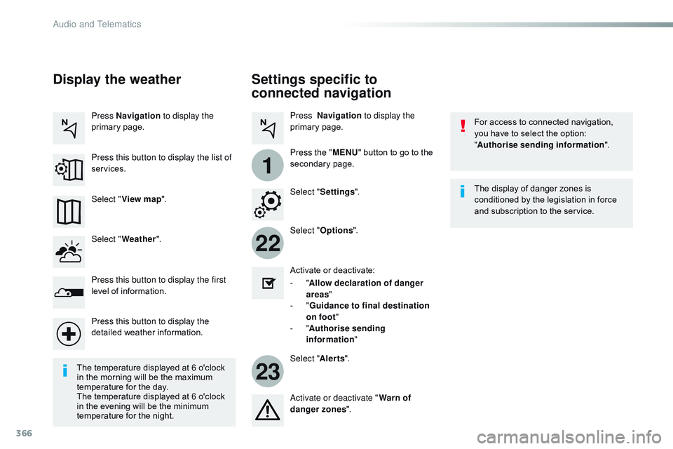
Settings specific to
connected navigation
For access to connected navigation,
you have to select the option:
"Authorise sending information ".
Select " Options ".
Select " Alerts".
-
" Allow declaration of danger
areas "
-
" Guidance to final destination
on foot "
-
" Authorise sending
information "
Activate or deactivate:
Activate or deactivate "
Warn of
danger zones ". The display of danger zones is
conditioned by the legislation in force
and subscription to the service.
The temperature displayed at 6 o'clock
in the morning will be the maximum
temperature for the day.
The temperature displayed at 6 o'clock
in the evening will be the minimum
temperature for the night. Select "
Settings ".
Press Navigation
to display the
primary page.
Press the " MENU" button to go to the
secondary page.
Display the weather
Select " Weather ".
Press this button to display the first
level of information.
Press this button to display the
detailed weather information. Select " View map ".
Press Navigation
to display the
primary page.
Press this button to display the list of
services.
Audio and Telematics
Page 369 of 774
367
Spacetourer-VP_en_Chap10b_NAC-1_ed01-2016
To distribute information on the
declaration of danger zones, you
should check the option: "Allow
declaration of danger areas ".You can download updates to the
system, danger zones and mapping,
from the brand's website.
The download procedure can be found
in the same place.
Declaration of "Danger
areas"
Press Navigation
to display the
primary page.
Press the "Declare a new danger
area" button located in the upper bar
of the touch screen.
Select the option " Ty p e" to choose
the type of "Danger area".
Select the " Speed" option and enter
it using the virtual keypad.
Press " Confirm " to save and
distribute the information.
.
Audio and Telematics
Page 370 of 774
368
2
7
3
8
465
12:13
23 °C531 kHz
1
Spacetourer-VP_en_Chap10b_NAC-1_ed01-2016
Level 1 Level 2Level 3
Bluetooth connection
Wi-Fi network connection
Networks
Share Wi-Fi connection
Connections and subscriptions to services
Functionalities available according to equipment.Connectivity
Audio and Telematics
Trending: clock, horn, fog light bulb, oil change, brake fluid, mirror, Adblue range


