NISSAN FRONTIER 2008 D22 / 1.G 04IT Navigation Manual
FRONTIER 2008 D22 / 1.G
NISSAN
NISSAN
https://www.carmanualsonline.info/img/5/794/w960_794-0.png
NISSAN FRONTIER 2008 D22 / 1.G 04IT Navigation Manual
Page 40 of 270
Black plate (40,1)
Model "NISSAN_NAVI" EDITED: 2007/ 2/ 26
NAV2741
3. A confirmation message is displayed. High-
light [Yes] and push.
INFO:
If a route is cancelled, [Cancel Route Guidance]
changes to [Resume Route Guidance].
Highlight [Resume Route Guidance] and push
to reactivate the cancelled route.
This is available only until a new route is set.
NAI0412
Delete the route using
(350Z)
1. Push.
NAV3024
2. A confirmation message is displayed. High-
light [Yes] and push.
2-34Getting started
Page 47 of 270

Black plate (7,1)
3 Map settings
Model "NISSAN_NAVI" EDITED: 2007/ 2/
Map types........................................................ 3-2
Plan view..................................................... 3-2
Birdview
TM.................................................... 3-3
Switching the map view....................................... 3-4
Available views.............................................. 3-5
Moving a map................................................... 3-7
Plan view..................................................... 3-7
Birdview
TM.................................................... 3-8
Returning to the current vehicle location.............. 3-9
Map scrolling information............................... 3-10Changing the scale of a map.............................. 3-12
Map scale.................................................. 3-13
Other settings for the map screen........................ 3-15
Settings of heading/long range map view........... 3-15
Changing the Birdview
TMangle....................... 3-17
Changing the scale of the left screen................ 3-20
Map icons...................................................... 3-22
Displaying landmark icons.............................. 3-22
Map symbols............................................... 3-24
Page 48 of 270
Black plate (48,1)
Model "NISSAN_NAVI" EDITED: 2007/ 2/ 26
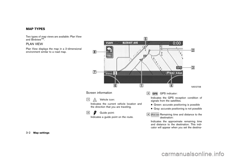
Two types of map views are available: Plan View
and BirdviewTM.
PLAN VIEW
Plan View displays the map in a 2-dimensional
environment similar to a road map.
NAV2708
Screen information
&1Vehicle icon:
Indicates the current vehicle location and
the direction that you are traveling.
&2Guide point:
Indicates a guide point on the route.
&3GPS indicator:
Indicates the GPS reception condition of
signals from the satellites.
*Green: accurate positioning is possible
*Gray: accurate positioning is not possible
&4Remaining time and distance to the
destination:
Indicates the approximate remaining time
and distance to the destination. This indi-
cator will appear when you set the destina-
MAP TYPES
3-2Map settings
Page 49 of 270
Black plate (49,1)
Model "NISSAN_NAVI" EDITED: 2007/ 2/ 26
tion and start route guidance.
&5Suggested route:
Appears in bold yellow during route gui-
dance.
&6/Direction indicator:
Indicates the direction of the map.
&7Scale indicator:
Indicates the scale of the map.
&8Arrow:
Indicates the distance to the next guide
point and the turning direction at that guide
point.
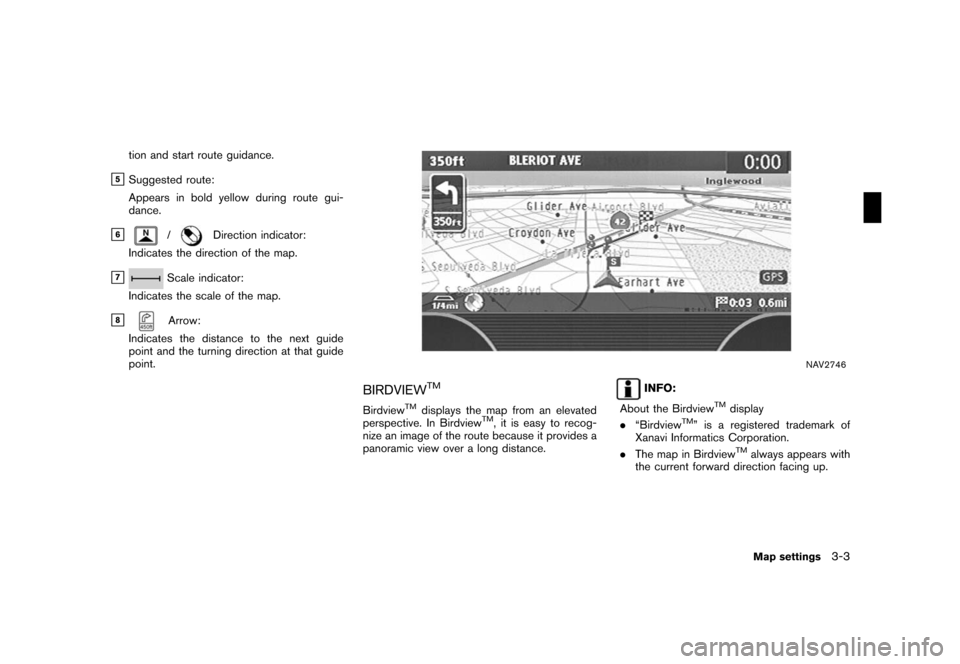
NAV2746
BIRDVIEWTM
BirdviewTMdisplays the map from an elevated
perspective. In BirdviewTM, it is easy to recog-
nize an image of the route because it provides a
panoramic view over a long distance.
INFO:
About the Birdview
TMdisplay
.“BirdviewTM” is a registered trademark of
Xanavi Informatics Corporation.
.The map in Birdview
TMalways appears with
the current forward direction facing up.
Map settings3-3
Page 50 of 270
Black plate (50,1)
Model "NISSAN_NAVI" EDITED: 2007/ 2/ 26
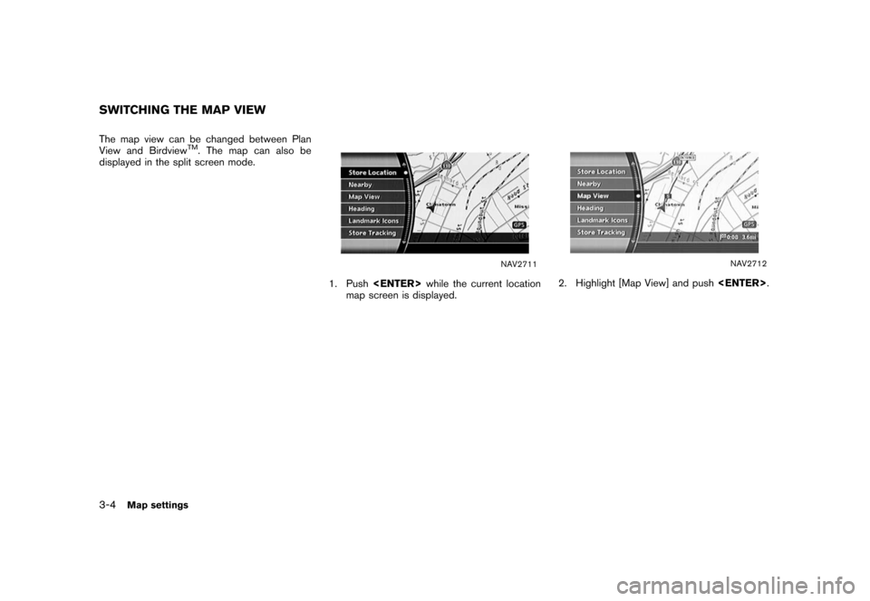
The map view can be changed between Plan
View and BirdviewTM. The map can also be
displayed in the split screen mode.
NAV2711
1. Pushwhile the current location
map screen is displayed.
NAV2712
2. Highlight [Map View] and push.
SWITCHING THE MAP VIEW
3-4Map settings
Page 51 of 270
Black plate (51,1)
Model "NISSAN_NAVI" EDITED: 2007/ 2/ 26
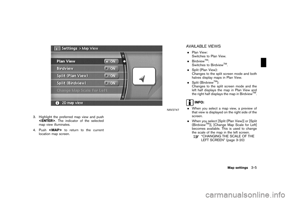
NAV2747
3. Highlight the preferred map view and push
. The indicator of the selected
map view illuminates.
4. Push
Page 55 of 270
Black plate (55,1)
Model "NISSAN_NAVI" EDITED: 2007/ 2/ 26
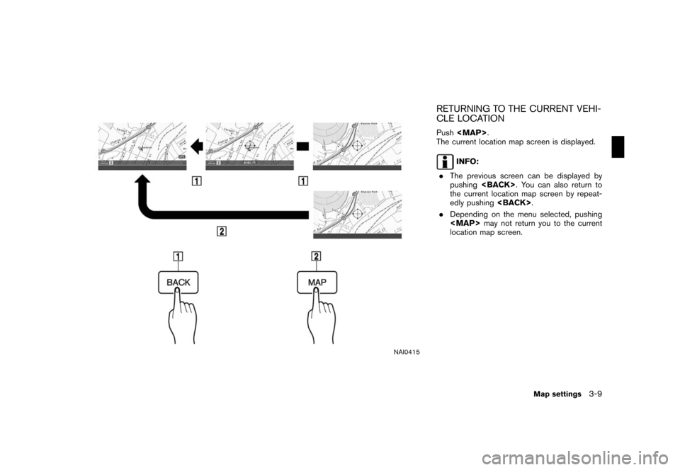
NAI0415
RETURNING TO THE CURRENT VEHI-
CLE LOCATION
Push
Page 56 of 270
Black plate (56,1)
Model "NISSAN_NAVI" EDITED: 2007/ 2/ 26
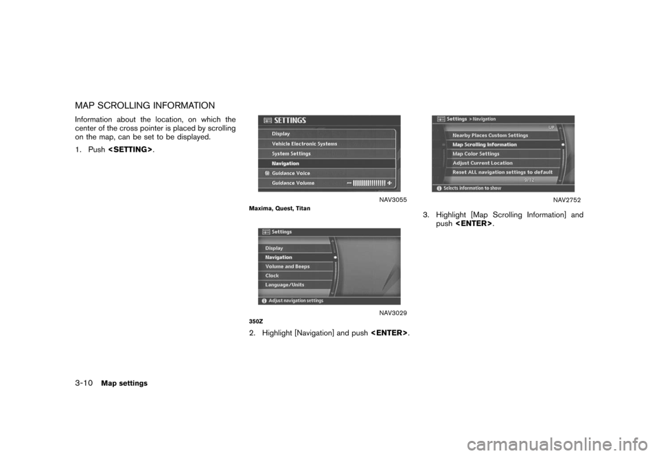
MAP SCROLLING INFORMATION
Information about the location, on which the
center of the cross pointer is placed by scrolling
on the map, can be set to be displayed.
1. Push.
NAV3055Maxima, Quest, Titan
NAV3029350Z
2. Highlight [Navigation] and push.
NAV2752
3. Highlight [Map Scrolling Information] and
push.
3-10Map settings
Page 57 of 270
Black plate (57,1)
Model "NISSAN_NAVI" EDITED: 2007/ 2/ 26
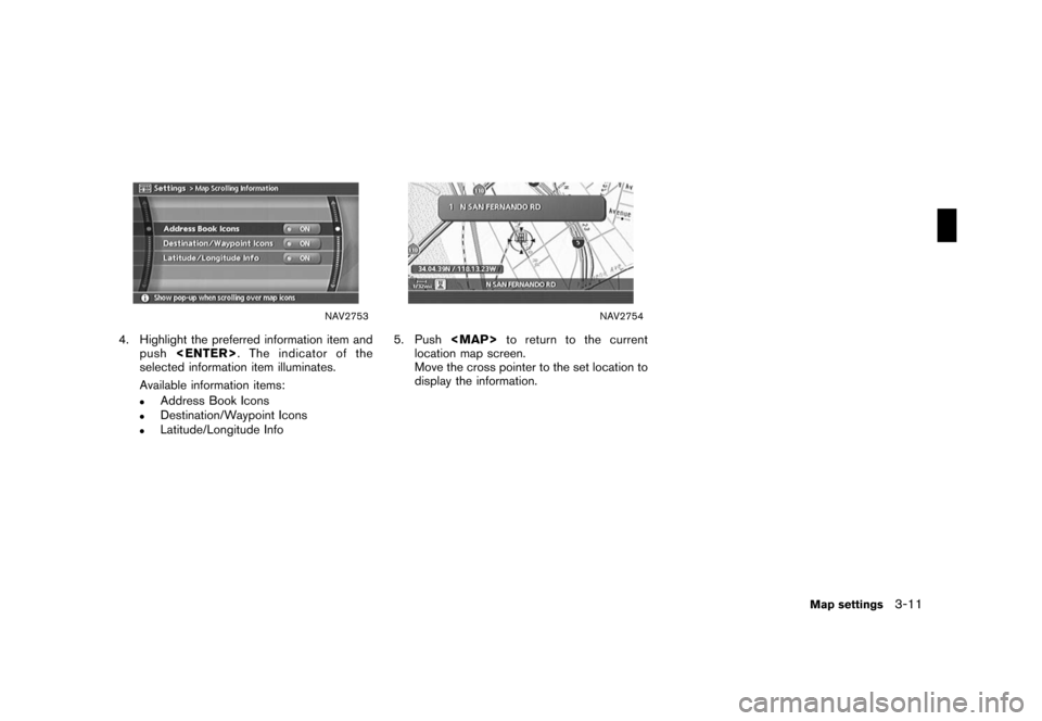
NAV2753
4. Highlight the preferred information item and
push. The indicator of the
selected information item illuminates.
Available information items:
.Address Book Icons.Destination/Waypoint Icons.Latitude/Longitude Info
NAV2754
5. Pushto return to the current
location map screen.
Move the cross pointer to the set location to
display the information.
Map settings3-11
Page 59 of 270
Black plate (59,1)
Model "NISSAN_NAVI" EDITED: 2007/ 2/ 26
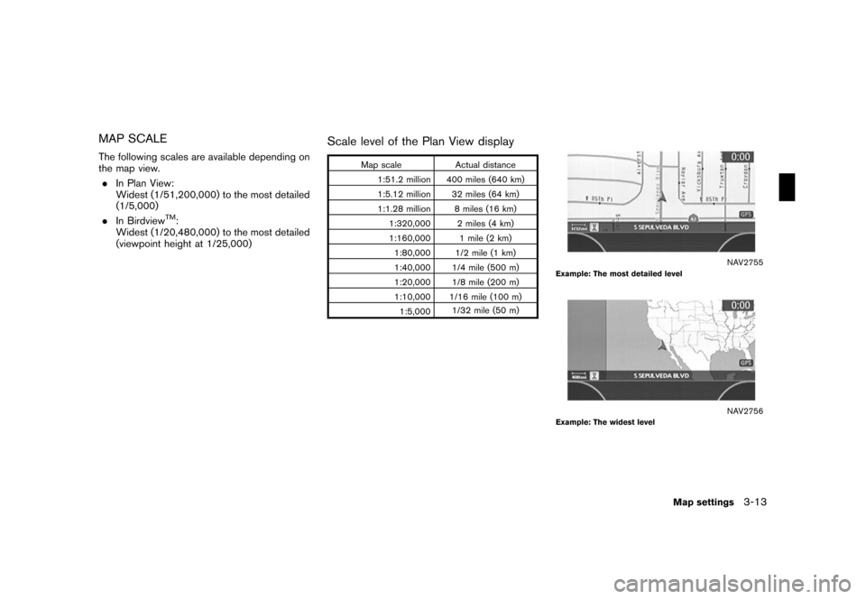
MAP SCALE
The following scales are available depending on
the map view.
.In Plan View:
Widest (1/51,200,000) to the most detailed
(1/5,000)
.In Birdview
TM:
Widest (1/20,480,000) to the most detailed
(viewpoint height at 1/25,000)
Scale level of the Plan View display
Map scale Actual distance
1:51.2 million 400 miles (640 km)
1:5.12 million 32 miles (64 km)
1:1.28 million 8 miles (16 km)
1:320,000 2 miles (4 km)
1:160,000 1 mile (2 km)
1:80,000 1/2 mile (1 km)
1:40,000 1/4 mile (500 m)
1:20,000 1/8 mile (200 m)
1:10,000 1/16 mile (100 m)
1:5,0001/32 mile (50 m)
NAV2755Example: The most detailed level
NAV2756Example: The widest level
Map settings3-13
![NISSAN FRONTIER 2008 D22 / 1.G 04IT Navigation Manual Black plate (40,1)
Model "NISSAN_NAVI" EDITED: 2007/ 2/ 26
NAV2741
3. A confirmation message is displayed. High-
light [Yes] and push<ENTER>.
INFO:
If a route is cancelled, [Cancel Route Guidance]
cha NISSAN FRONTIER 2008 D22 / 1.G 04IT Navigation Manual Black plate (40,1)
Model "NISSAN_NAVI" EDITED: 2007/ 2/ 26
NAV2741
3. A confirmation message is displayed. High-
light [Yes] and push<ENTER>.
INFO:
If a route is cancelled, [Cancel Route Guidance]
cha](/img/5/794/w960_794-39.png)

