navigation TOYOTA SUPRA 2021 Accessories, Audio & Navigation (in English)
[x] Cancel search | Manufacturer: TOYOTA, Model Year: 2021, Model line: SUPRA, Model: TOYOTA SUPRA 2021Pages: 92, PDF Size: 1.84 MB
Page 21 of 92
211-1. NAVIGATION
1
NAVIGATION
Supra Navigation System Owner’s Manual_U (from Nov. ’20 Prod.)
"Auto zoom with info": with
active destination guidance,
the map is enlarged automati-
cally when approaching a
maneuver. In addition, desti-
nation guidance hints are dis-
played on the map.
"Manual zoom": enlarge or
reduce map scale manually.
"Route overview": display
the route between current
location and the destination.
If destination guidance is active,
destination guidance hints can
be displayed in the map view for
the respective maneuvering
points of the current route.
In the case of multi-lane roads,
lane information may indicate
the recommended lanes.
In the Professional navigation
system:
Destination guidance hints can
also be displayed as arrow view
in the split screen, refer to page
27. Different information can be
called up for any point on the
map and settings can be
adjusted.
Here, the map can be used via
Toyota Supra Command.
1
"Navigation"
2 "Map"
3 Move the Controller to the
left.
4 "Interactive map"
5 Select the destination with
crosshairs.
To change the scale: turn the
Controller.
To shift the map: move the
Controller in the required
direction.
To shift the map diagonally:
Destination guidance hints
Concept
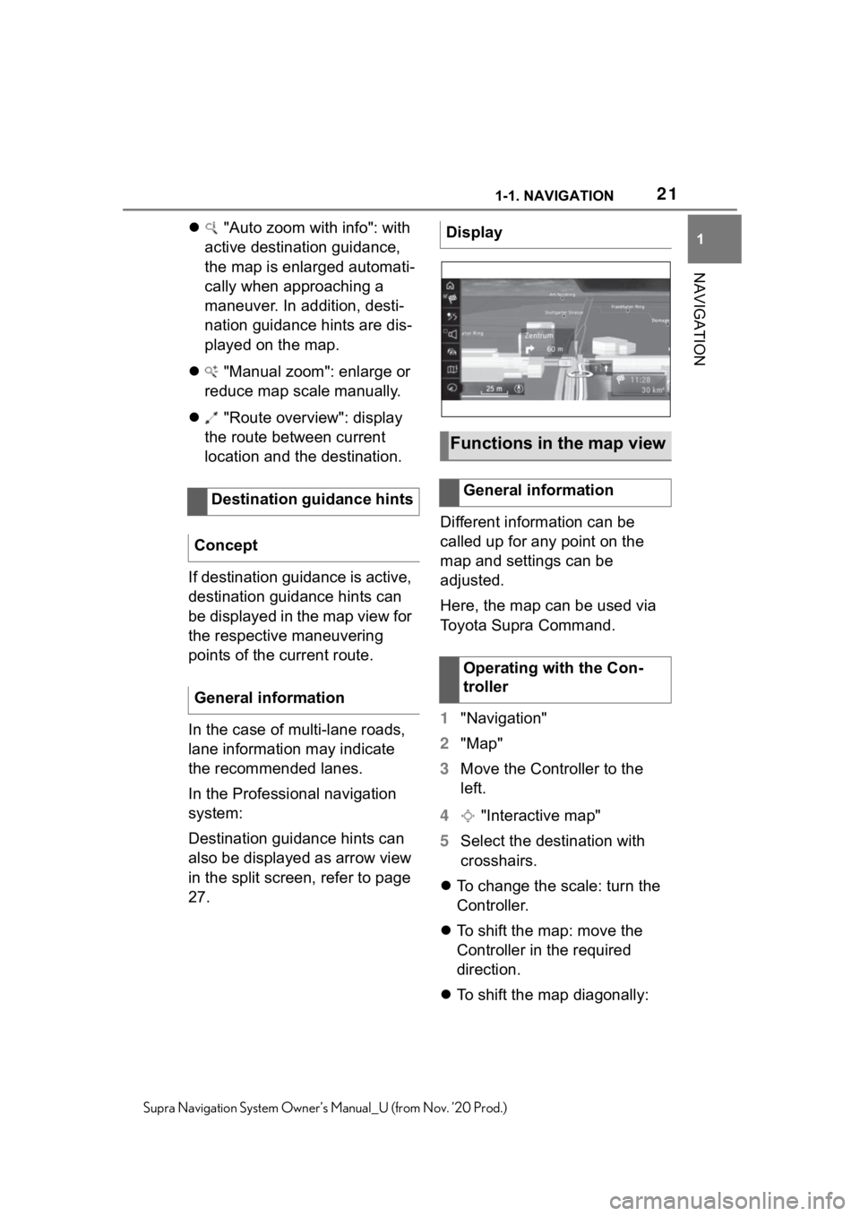
General informationDisplay
Functions in the map view
General information
Operating with the Con-
troller
Page 22 of 92

221-1. NAVIGATION
Supra Navigation System Owner’s Manual_U (from Nov. ’20 Prod.)
move the Controller in the
required direction and turn it.
6 Press the Controller.
7 Select the desired setting.
Different functions are available
depending on the point selected
on the map:
"Repeat voice instruction"
With destination guidance active.
"Start guidance": start des-
tination guidance.
"Add as intermediate
dest.": add destination.
"Show details": details
about the destination can be
displayed as necessary.
"Show details": if the cross-
hairs are positioned over a
place with multiple Points of
Interest, these destinations
will be displayed in a list.
"Leave interactive map":
with operation via the Control-
ler: end interactive map.
If equipped with touchscreen:
"Back to current location":
change to normal map view.
"Show destination": the
map section around the desti-
nation is displayed.
"Save position": store cur-
rent position as contact.
"Change map view":
change the map view.
Functions
Page 23 of 92
231-1. NAVIGATION
1
NAVIGATION
Supra Navigation System Owner’s Manual_U (from Nov. ’20 Prod.)
This chapter describes all stan-
dard, country-specific and
optional features offered with
the series. It also describes fea-
tures and functions that are not
necessarily available in your
vehicle, e. g., due to the
selected options or country ver-
sions. This also applies to
safety-related functions and sys-
tems. When using these func-
tions and systems, the
applicable laws and regulations
must be observed.
Navigation settings can be indi-
vidually configured. Settings are
stored for the driver profile cur-
rently used.
The route criteria can be individ-
ually adjusted. The settings are
stored as standard and auto-
matically applied to new desti-
nation guidances.
1"Navigation" 2
"Settings"
3 "Route settings"
4 "Default preference"
5 Select desired setting:
"Fast": time-optimized route,
being a combination of the
shortest possible route and
the fastest roads.
"ECO" or "Efficient": efficient
route, being a combination of
the route requiring low con-
sumption and fast roads.
The time of arrival and consump-
tion are based on driving in ECO
Driving mode and a moderate driv-
ing style.
"Short": distance-optimized
route, being a combination of
the shortest possible route
and the fastest roads.
1 "Navigation"
2 "Settings"
3 "Route settings"
4 Select desired setting:
Settings for dynamic destina-
tion guidance:
• "Automatic": traffic bulletins are
considered in destination guid-
ance. The current route is auto-
matically changed as needed.
Depending on the equipment ver-
sion, online alternative routes are
Settings
Vehicle features and
options
General information
Route
Concept
Default preference
Further criteria
Settings
Page 24 of 92
241-1. NAVIGATION
Supra Navigation System Owner’s Manual_U (from Nov. ’20 Prod.)automatically applied as well.
• "With confirmation": if suitable
detours are available, a message
is displayed first.
"Toll roads"
•"Avoid"
• "Use cash"
• "Toll tag"
In the Professional navigation
system: "Online routes":
accept online alternative
routes.
In the Professional navigation
system: "Learn route": if multi-
ple identical departures from
the proposed route are made,
this deviation is taken into
account in future route plan-
ning.
"Avoid highways": highways
are avoided wherever possi-
ble.
"Avoid ferries": ferries are
avoided where possible.
"Avoid carpool roads": carpool
lanes are avoided where pos-
sible.
■Concept
Areas that should be driven
around can be specified as
areas to be avoided.
■Defining an area to be
avoided
1 "Navigation"
2 "Settings"
3 "Route settings"
4 "Areas to avoid"
5 "Set new area to avoid"
6 Follow the instructions on the
Control Display.
7 "Accept area"
■Deleting areas to be
avoided
1 "Navigation"
2 "Settings"
3 "Route settings"
4 "Areas to avoid"
5 If necessary, mark desired
area to be avoided.
6 Press the button.
7 Delete desired area to be
avoided or all areas to be
avoided.
In the map view, colored lines
show the probability of finding a
vacant parking space along a
street. The list of cities/towns for
which parking information is
available can be displayed.
In the Professional naviga-
tion system: areas to be
avoided
In the Professional navi-
gation system: parking
information
Concept
Page 25 of 92
251-1. NAVIGATION
1
NAVIGATION
Supra Navigation System Owner’s Manual_U (from Nov. ’20 Prod.)
1"Navigation"
2 "Settings"
3 "Available on-street parking
info"
The list of cities/towns is displayed.
The map view can be individu-
ally adjusted, for instance the
map color and mode can be set.
It can also be defined, which
Points of Interest are shown on
the map.
1"Navigation"
2 "Settings"
3 Select the desired setting.
The home address can be spec-
ified or changed.
1 "Navigation"
2 "Settings" 3
"Set home address" or
"Change home address"
Information regarding position
determination and navigation
data version can be called up.
1 "Navigation"
2 "Settings"
3 "Position and software ver-
sion"
4 Select desired setting:
"Enter position": the vehicle
position can be manually set
on the map in situations with-
out GPS reception or, for
instance immediately after
transport on a ferry.
"Software version": informa-
tion about the current map
version.
In the Professional navigation
system:
"Help to improve the navigation
map": data such as speed or posi-
tion is stored in the vehicle in an
anonymized state and transmitted
to the manufacturer in order to
improve the digital map.
1 "Navigation"
Displaying the list of cit-
ies/towns
Map
Concept
Setting the map
Home address
Concept
Setting the home address
Navigation data
Concept
Settings
Resetting the settings
Page 26 of 92
261-1. NAVIGATION
Supra Navigation System Owner’s Manual_U (from Nov. ’20 Prod.)
2"Settings"
3 Press the button.
4 "Reset all settings"
This chapter describes all stan-
dard, country-specific and
optional features offered with
the series. It also describes fea-
tures and functions that are not
necessarily available in your
vehicle, e. g., due to the
selected options or country ver-
sions. This also applies to
safety-related functions and sys-
tems. When using these func-
tions and systems, the
applicable laws and regulations
must be observed.
Different views can be set for
the split screen separately from
the main screen.
1Move the Controller to the
right until the split screen is
selected.
2 Press the Controller.
3 Select desired setting:
"Map": set the map view.
• "Map view:": select the map view.
• "Traffic flow": display the traffic
flow.
• "Traffic icons": display traffic events.
Split screen
Vehicle features and
options
Concept
Settings
Page 27 of 92
271-1. NAVIGATION
1
NAVIGATION
Supra Navigation System Owner’s Manual_U (from Nov. ’20 Prod.)• "Route overview
": display the
route overview.
"Arrow display": with destina-
tion guidance active, the
arrow view is displayed. If no
destination guidance is active,
a compass is displayed.
"Position": display current
position.
"Exit ramp view": selected
route sections, for instance
major road intersections, are
shown in perspective view.
If destination guidance is active,
the destination guidance hints
can be displayed as list in the
split screen.
It is possible to set which addi-
tional information should be dis-
played in the arrow view.
In the case of multi-lane roads,
lane information may indicate
the recommended lanes.
1 Move the Controller to the
right until the split screen is
selected.
2 Press the Controller.
3 "Arrow display" 4
Press the button.
5 Select desired setting:
"Traffic Info": display traffic
flow and traffic events.
"Additional information": dis-
play additional information
such as tunnels.
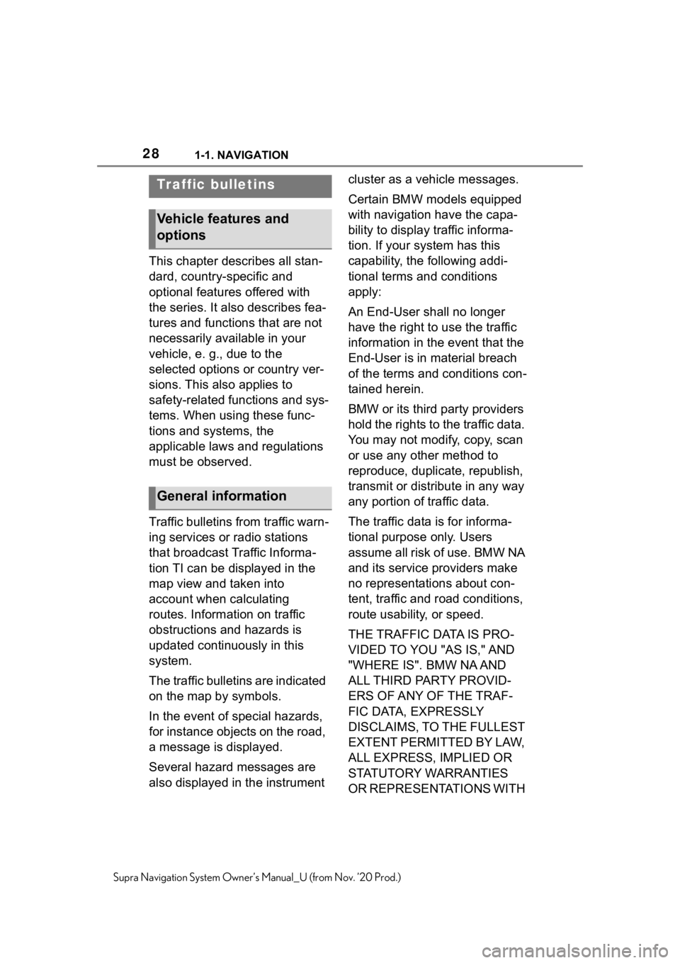
The following information is dis-
played during destination guid-
ance:
1 Turn information
2 Traffic flow and traffic events
3 Upcoming street
4 Distance to maneuver
5 Lane information
6 Current road
Depending on the country-spe-
cific version, the display may
deviate from what is depicted.
Arrow view
Concept
General information
Settings
Display
Page 28 of 92
281-1. NAVIGATION
Supra Navigation System Owner’s Manual_U (from Nov. ’20 Prod.)
This chapter describes all stan-
dard, country-specific and
optional features offered with
the series. It also describes fea-
tures and functions that are not
necessarily available in your
vehicle, e. g., due to the
selected options or country ver-
sions. This also applies to
safety-related functions and sys-
tems. When using these func-
tions and systems, the
applicable laws and regulations
must be observed.
Traffic bulletins from traffic warn-
ing services or radio stations
that broadcast Traffic Informa-
tion TI can be displayed in the
map view and taken into
account when calculating
routes. Information on traffic
obstructions and hazards is
updated continuously in this
system.
The traffic bulletins are indicated
on the map by symbols.
In the event of special hazards,
for instance objects on the road,
a message is displayed.
Several hazard messages are
also displayed in the instrument cluster as a vehicle messages.
Certain BMW models equipped
with navigation have the capa-
bility to display traffic informa-
tion. If your system has this
capability, the following addi-
tional terms and conditions
apply:
An End-User shall no longer
have the right to use the traffic
information in the event that the
End-User is in material breach
of the terms and conditions con-
tained herein.
BMW or its third party providers
hold the rights to the traffic data.
You may not modify, copy, scan
or use any other method to
reproduce, duplicate, republish,
transmit or distribute in any way
any portion of traffic data.
The traffic data is for informa-
tional purpose only. Users
assume all risk of use. BMW NA
and its service providers make
no representations about con-
tent, traffic and road conditions,
route usability, or speed.
THE TRAFFIC DATA IS PRO-
VIDED TO YOU "AS IS," AND
"WHERE IS". BMW NA AND
ALL THIRD PARTY PROVID-
ERS OF ANY OF THE TRAF-
FIC DATA, EXPRESSLY
DISCLAIMS, TO THE FULLEST
EXTENT PERMITTED BY LAW,
ALL EXPRESS, IMPLIED OR
STATUTORY WARRANTIES
OR REPRESENTATIONS WITH
Traffic bulletins
Vehicle features and
options
General information
Page 29 of 92
291-1. NAVIGATION
1
NAVIGATION
Supra Navigation System Owner’s Manual_U (from Nov. ’20 Prod.)
RESPECT TO THE TRAFFIC
DATA (INCLUDING, WITHOUT
LIMITATION, THAT THE TRAF-
FIC DATA WILL BE
ERROR-FREE, WILL OPER-
ATE WITHOUT INTERRUP-
TION OR THAT THE TRAFFIC
DATA WILL BE ACCURATE),
INCLUDING, WITHOUT LIMITA-
TION, THE IMPLIED WARRAN-
TIES OF MERCHANTABILITY,
NON-INFRINGEMENT FIT-
NESS FOR A PARTICULAR
PURPOSE, OR THOSE ARIS-
ING FROM A COURSE OF
DEALING OR USAGE OF
TRADE
NEITHER BMW NA NOR ITS
THIRD PARTY PROVIDERS
WILL BE LIABLE TO YOU FOR
ANY INDIRECT, SPECIAL,
CONSEQUENTIAL, EXEM-
PLARY, OR INCIDENTAL DAM-
AGES (INCLUDING, WITHOUT
LIMITATION, LOST REVE-
NUES, ANTICIPATED REVE-
NUES, OR PROFITS
RELATING TO THE SAME)
ARISING FROM ANY CLAIM
RELATING DIRECTLY OR
INDIRECTLY TO USE OF THE
TRAFFIC DATA, AND EVEN IF
BMW NA OR ITS THIRD
PARTY PROVIDERS ARE
AWARE OF THE POSSIBILITY
OF SUCH DAMAGES. THESE
LIMITATIONS APPLY TO ALL
CLAIMS, INCLUDING, WITH-
OUT LIMITATION, CLAIMS IN
CONTRACT AND TORT (SUCH AS NEGLIGENCE, PRODUCT
LIABILITY AND STRICT LIA-
BILITY). SOME STATES DO
NOT ALLOW THE EXCLU-
SION OR LIMITATION OF INCI-
DENTAL OR
CONSEQUENTIAL DAM-
AGES, SO THOSE PARTICU-
LAR LIMITATIONS MAY NOT
APPLY TO YOU.
In some countries, RTTI is
transmitted via services which
can be booked in addition.
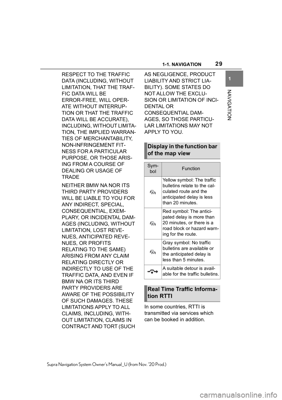
Display in the function bar
of the map view
Sym-
bolFunction
Yellow symbol: The traffic
bulletins relate to the cal-
culated route and the
anticipated delay is less
than 20 minutes.
Red symbol: T he antici-
pated delay is more than
20 minutes, or there is a
road block or hazard warn-
ing for the route.
Gray symbol: No traffic
bulletins are available or
the anticipated delay is
less than 5 minutes.
A suitable detour is avail-
able for the traffic bulletins.
Real Time Traffic Informa-
tion RTTI
Page 30 of 92

301-1. NAVIGATION
Supra Navigation System Owner’s Manual_U (from Nov. ’20 Prod.)
RTTI is then used and displayed
instead of the traffic bulletins
from the radio stations.
With RTTI, traffic obstructions
are localized more comprehen-
sively and precisely. Traffic con-
ditions on roads other than the
highways, for instance second-
ary roads and urban streets are
also recorded and displayed for
a wide area. Recommended
detours can be calculated more
accurately on the basis of this
information. The risk of becom-
ing caught in a further traffic
obstruction on detour routes is
reduced. If applicable, several
detour recommendations or
additional information may be
offered.
When traveling in countries
where RTTI is not available, the
traffic bulletins from the radio
stations are still used, if possi-
ble.
The function bar in the map
view, refer to page 13, shows
whether Traffic Information TI or
RTTI is being used.
1"Navigation"
2 "Settings"
3 "Receive Traffic Info" 1
"Navigation"
2 "Map"
3 Move the Controller to the
left.
4 "Traffic Info"
With active destination guidance,
first the traffic bulletins for the cal-
culated route are displayed with red
symbols. Then, the traffic bulletins
that do not affec t the route are
shown with gray sym bols. The traf-
fic bulletins are sor ted by their dis-
tance from the cur rent position of
the vehicle.
5 Select a traffic bulletin.
"Previous message": scroll to
the previous traffic bulletin.
"Next message": scroll to the
next traffic bulletin.
1 "Navigation"
2 "Map"
3 "Traffic Info"
4 "Detour": a detour recom-
mendation is displayed.
The following functions are avail-
able:
"Current route": stay on cur-
rent route.
"New route in": accept detour.
Switching on/off
Displaying list of traffic
bulletins
Displaying detour recom-
mendation