rest Acura MDX 2007 Navigation Manual
[x] Cancel search | Manufacturer: ACURA, Model Year: 2007, Model line: MDX, Model: Acura MDX 2007Pages: 166, PDF Size: 4.21 MB
Page 111 of 166
110Navigation System
System Initialization
GPS Initialization
Depending on the length of time the
battery was disconnected, your system
may require GPS initialization. If it
does, the following screen appears:
If this procedure is not necessary, the
system proceeds directly to the
Disclaimer screen (see page 17).
During initialization, the system
searches for all available GPS satellites,
and obtains their orbital information.
During this procedure the vehicle
should be out in th e open with a clear
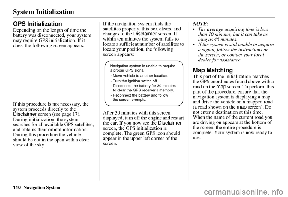
view of the sky. If the navigation system finds the
satellites properly, this box clears, and
changes to the
Disclaimer screen. If
within ten minutes the system fails to
locate a sufficient number of satellites to
locate your position, the following
screen appears:
After 30 minutes with this screen
displayed, turn off the engine and restart
the car. If you now see the Disclaimer
screen, the GPS initialization is
complete. The green GPS icon should
appear in the upper left corner of the
screen. NOTE:
The average acquiring time is less
than 10 minutes, but it can take as
long as 45 minutes.
If the system is still unable to acquire a signal, follow the instructions on
the screen, or contact your local
dealer for assistance.
Map Matching
This part of the initialization matches
the GPS coordinates found above with a
road on the map screen. To perform this
part of the procedure, ensure that the
navigation system is displaying a map,
and drive the vehicle on a mapped road
(a road shown on the map screen). Do
not enter a destina tion at this time.
When the name of the current road you
are driving on appears at the bottom of
the screen, the entire procedure is
complete. Your system is now ready to
use.
Navigation system is unable to acquire
a proper GPS signal.
- Move vehicle to another location.
- Turn the ignition switch off.
- Disconnect the battery for 30 minutes
to clear the GPS receiver’s memory.
- Reconnect the battery and follow
the screen prompts.
Page 114 of 166
Navigation System113
Database Limitations
You will find that some points of
interest (POI) may be missing when you
search the database. This can be caused
if at the time the database was gathered,
the name was misspelled, the place was
improperly categorized, or the POI
change is not yet in the database. This
means you may not find places listed
that you know exist. This is also true for
police agencies and hospitals. In
outlying areas, facilities listed may not
be the closest. Always check with local
information sources if you need law
enforcement or hospital services.
Every effort has been made to verify
that the system’s database was accurate
at the time it was created. However,
businesses do fail or move to new
locations, and new businesses start in
the old locations. For this reason, you
may occasionally find “inaccurate”
information when you select and drive
to a point of interest (for example, a
restaurant is now a jewelry store). The
number of these inaccuracies increases
the longer you go without an update. The digitized map database reflects
conditions as they existed at various
points in time before production.
Accordingly, your
DVD may contain
inaccurate or inco mplete data or
information due to the passage of time,
road construction, ch anging conditions,
or other causes.
In addition, this database does not
include, analyze, pr ocess, consider, or
reflect any of the following categories
of information:
Neighborhood quality or safety
Population density
Availability or proximity of law enforcement
Emergency, rescue, medical, or other assistance
Construction work, zones, or hazards
Road and lane closures
Legal restrictions (such as vehicular type, weight, load, height, and speed
restrictions)
Road slope or grade Bridge height, width, weight, or other
limits
Road, traffic or traffic facilities safety, or conditions
Weather conditions
Special events
Pavement characteristics or conditions
Traffic congestion
Travel time
We assume no liability for any incident
that may result from an error in the
program, or from changed conditions
not noted above.
Copyrights
infoUSA-Data: Certain business data provided by infoUS A, Inc., Omaha,
Nebraska, Copyright © 2003, All
Rights Reserved.
EXIT-Data: © ZENRIN CO., LTD. 2003. All Rights Reserved.
ZAGAT SURVEY: Copyright © [2003] Zagat Survey, LLC. All rights
reserved.
Page 115 of 166
114Navigation System
Customer Assistance
Reporting Errors
Occasionally, you may encounter
database errors.
If the error pertains to freeways and main “verified” roads shown in black
on the map, then report it either
online at
http://update.navteq.com/, or to
Acura Customer Services.
If the error involves a light brown “unverified” road, then do not report
it. These areas have not been verified,
and are provided for reference only
(see Map Overview on page 6).
For errors in points of interest (POI), like a business that has changed their
name, do not report them. Keep in
mind that depending on when the data
was collected, and when your DVD
was purchased, the database can be
out of date. The business may have
not reported the change(s), or not be
in the database at all. Update
Navigation DVDs are available for
purchase, usually in the fall of each
year. If the error does not involve the
database, such as if the vehicle
position icon does not follow the
road, screen error messages, or other
GPS related errors, see Frequently
Asked Questions on page 128, System
Limitations on page 111 , or
Troubleshooting on page 136.
Acura Automobile Customer
Service
Telephone: (800) 382-2238
Fax: (310) 783-3535
Acura Navi
America Honda Motor Co., Inc.
Acura Client Services
MS 500-2N-7E
1919 Torrance Blvd.
Torrance, CA 90501-2746
If you desire more detailed information
on detailed map coverage, contact any
Acura dealer. Map coverage
information is at the Navigation DVD
order link, “ordering a Navigation
DVD” at: www.acura.com. The link is
found in “ACURA STORE.” Check the
“Coverage MAPS” link.
Page 126 of 166

Navigation System125
Coverage Areas
L’assomption
Charlemagne
Le Gardeur
Repentigny
La Vallee-du-Richelieu Beloeil
Caringnan
Chambly
Longueuil
McMasterville
Mont-St-Hilaire
Otterburn Park
St-Basile-le-Grand
St-Mathieu-de-Beloeil
Longueuil
Ste-Julie
Laval Laval
Les Moulins Lachenaie
Mascouche
Terrebonne
Longueuil Longueuil Montreal
Montreal
Rousillon
Candiac
Chateauguay
Delson
La Prairie
Lery
Ste-Catherine
St-Constant
Therese-de-Blainville Blainville
Boisbriand
Bois-des-Filion
Lorraine
Rosemere
Ste-Therese
Vaudreuil-Soulanges Hudson
L’Ile-Cadieux
L’Ile-Perrot
Notre-Dame-de-l’Ile-Perrot
Pincourt
St-Lazare
Terrasse-Vaudreuil
Vaudreuil-Dorion
Vaudreuil-sur-le-Lac
Québec QuébecCANADA CONNECTOR ROADS
The Cross-Canada Connector Road
allows for travel between the
provinces of British Columbia and
Quebec in DCA 11. Major
metropolitan city Points of interest
are also included.
Road Inclusion
Roads in the province of British
Columbia Hwy-1/Trans Canada Hwy from
Alberta/BC boundary to Vancouver
detailed city.
Hwy-3/Crowsnest Hwy from Hwy-1/
Trans Canada Hwy (Hope) to Hwy-5/
Coquihalla Hwy (Hope)
Hwy-5/Coquihalla Hwy (in Hope) to
Hwy-1/Trans Canada Hwy (in
Kamloops)
Hwy-99 between Vancouver and
Whistler
Page 129 of 166
128Navigation System
Frequently Asked Questions
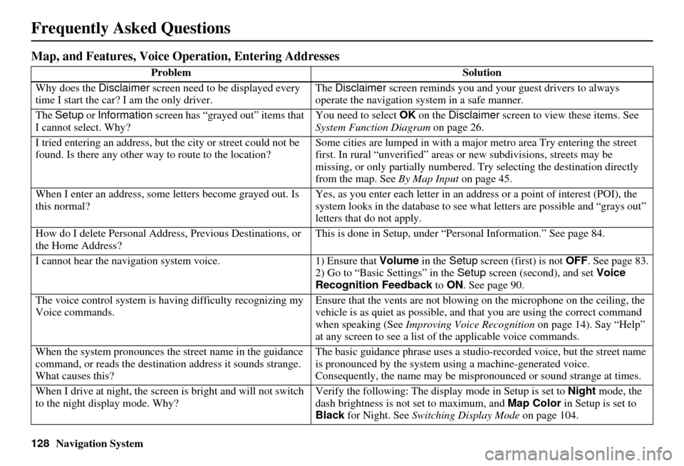
Map, and Features, Voice Operation, Entering Addresses
Problem Solution
Why does the Disclaimer screen need to be displayed every
time I start the car? I am the only driver. The
Disclaimer screen reminds you and your guest drivers to always
operate the navigation sy stem in a safe manner.
The Setup or Information screen has “grayed out” items that
I cannot select. Why? You need to select
OK on the Disclaimer screen to view these items. See
System Function Diagram on page 26.
I tried entering an address, but th e city or street could not be
found. Is there any other way to route to the location? Some cities are lumped in with a major metro area Try entering the street
first. In rural “unverified” areas
or new subdivisions, streets may be
missing, or only partiall y numbered. Try selecting the destination directly
from the map. See By Map Input on page 45.
When I enter an address, some letters become grayed out. Is
this normal? Yes, as you enter each letter in an addr
ess or a point of interest (POI), the
system looks in the databa se to see what letters are possible and “grays out”
letters that do not apply.
How do I delete Personal Address, Previous Destinations, or
the Home Address? This is done in Setup, under “P
ersonal Information.” See page 84.
I cannot hear the navigation system voice. 1) Ensure that Volume in the Setup screen (first) is not OFF. See page 83.
2) Go to “Basic Settings” in the Setup screen (second), and set Voice
Recognition Feedback to ON . See page 90.
The voice control system is ha ving difficulty recognizing my
Voice commands. Ensure that the vents are not blowi
ng on the microphone on the ceiling, the
vehicle is as quiet as possible, and that you are using the correct command
when speaking (See Improving Voice Recognition on page 14). Say “Help”
at any screen to see a list of the applicable voice commands.
When the system pronounces the street name in the guidance
command, or reads the destinat ion address it sounds strange.
What causes this? The basic guidance phrase uses a studio
-recorded voice, but the street name
is pronounced by the system us ing a machine-generated voice.
Consequently, the name may be misp ronounced or sound strange at times.
When I drive at night, the screen is bright and will not switch
to the night display mode. Why? Verify the following: The disp
lay mode in Setup is set to Night mode, the
dash brightness is not set to maximum, and Map Color in Setup is set to
Black for Night. See Switching Display Mode on page 104.
Page 130 of 166
Navigation System129
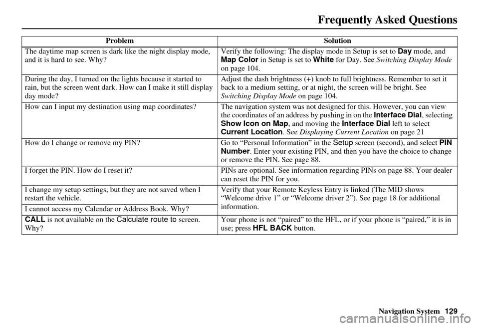
Frequently Asked Questions
The daytime map screen is dark like the night display mode,
and it is hard to see. Why? Verify the following: The disp
lay mode in Setup is set to Day mode, and
Map Color in Setup is set to White for Day. See Switching Display Mode
on page 104.
During the day, I turned on the lights because it started to
rain, but the screen went dark. How can I make it still display
day mode? Adjust the dash brightness (+) knob to fu
ll brightness. Remember to set it
back to a medium setting, or at ni ght, the screen will be bright. See
Switching Display Mode on page 104.
How can I input my destination using map coordinates? The navigation system was not designed for this. However, you can view
the coordinates of an address by pushing in on the Interface Dial, selecting
Show Icon on Map , and moving the Interface Dial left to select
Current Location . See Displaying Current Location on page 21
How do I change or remove my PIN? Go to “Personal Information” in the Setup screen (second) , and select PIN
Number . Enter your existing PIN, and then you have the choice to change
or remove the PIN. See page 88.
I forget the PIN. How do I reset it? PINs are optional. See information regarding PINs on page 88. Your dealer
can reset the PIN for you.
I change my setup settings, bu t they are not saved when I
restart the vehicle. Verify that your Remote Keyless
Entry is linked (The MID shows
“Welcome drive 1” or “Welcome dr iver 2”). See page 18 for additional
information.
I cannot access my Calendar or Address Book. Why?
CALL is not available on the Calculate route to screen.
Why? Your phone is not “paired” to the HFL,
or if your phone is “paired,” it is in
use; press HFL BACK button.
Problem
Solution
Page 138 of 166
Navigation System137
Glossary
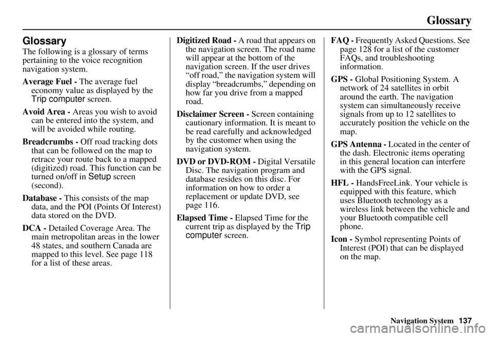
Glossary
The following is a glossary of terms
pertaining to the voice recognition
navigation system.
Average Fuel - The average fuel
economy value as displayed by the
Trip computer screen.
Avoid Area - Areas you wish to avoid
can be entered into the system, and
will be avoided while routing.
Breadcrumbs - Off road tracking dots
that can be followe d on the map to
retrace your route back to a mapped
(digitized) road. This function can be
turned on/off in Setup screen
(second).
Database - This consists of the map
data, and the POI (Points Of Interest)
data stored on the DVD.
DCA - Detailed Coverage Area. The
main metropolitan areas in the lower
48 states, and southern Canada are
mapped to this level. See page 118
for a list of these areas. Digitized Road -
A road that appears on
the navigation screen. The road name
will appear at the bottom of the
navigation screen. If the user drives
“off road,” the navigation system will
display “breadcrumbs,” depending on
how far you drive from a mapped
road.
Disclaimer Screen - Screen containing
cautionary information. It is meant to
be read carefully and acknowledged
by the customer when using the
navigation system.
DVD or DVD-ROM - Digital Versatile
Disc. The navigation program and
database resides on this disc. For
information on how to order a
replacement or update DVD, see
page 116.
Elapsed Time - Elapsed Time for the
current trip as displayed by the Trip
computer screen. FAQ -
Frequently Asked Questions. See
page 128 for a list of the customer
FAQs, and troubleshooting
information.
GPS - Global Positioning System. A
network of 24 satellites in orbit
around the earth. The navigation
system can simultaneously receive
signals from up to 12 satellites to
accurately position the vehicle on the
map.
GPS Antenna - Located in the center of
the dash. Electronic items operating
in this general location can interfere
with the GPS signal.
HFL - HandsFreeLink. Your vehicle is
equipped with this feature, which
uses Bluetooth technology as a
wireless link between the vehicle and
your Bluetooth compatible cell
phone.
Icon - Symbol representing Points of
Interest (POI) that can be displayed
on the map.
Page 139 of 166
138Navigation System
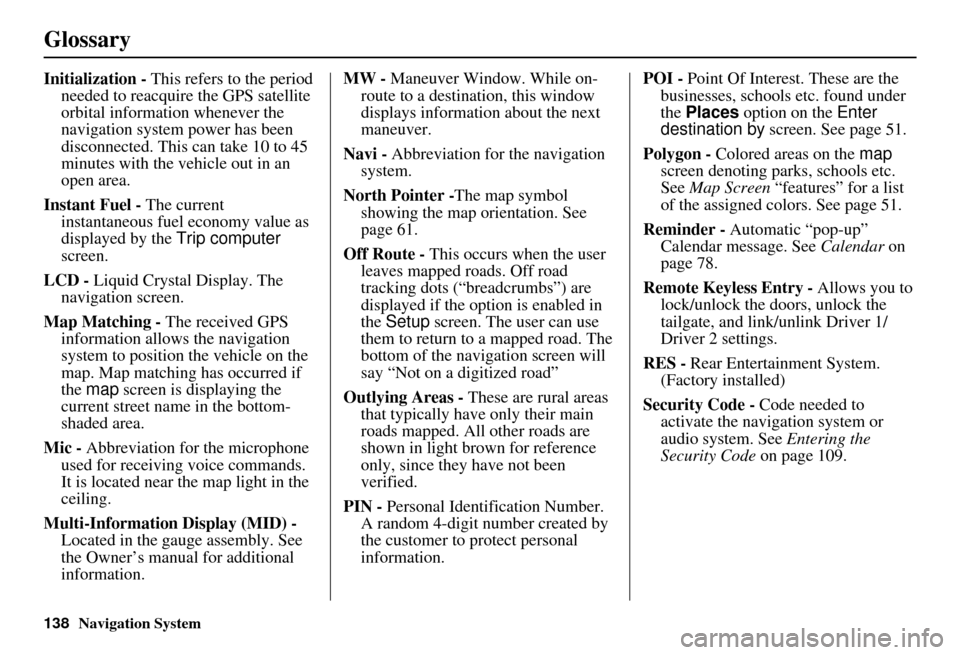
Glossary
Initialization - This refers to the period
needed to reacquire the GPS satellite
orbital information whenever the
navigation system power has been
disconnected. This can take 10 to 45
minutes with the ve hicle out in an
open area.
Instant Fuel - The current
instantaneous fuel economy value as
displayed by the Trip computer
screen.
LCD - Liquid Crystal Display. The
navigation screen.
Map Matching - The received GPS information allows the navigation
system to position the vehicle on the
map. Map matching has occurred if
the map screen is displaying the
current street name in the bottom-
shaded area.
Mic - Abbreviation for the microphone
used for receiving voice commands.
It is located near the map light in the
ceiling.
Multi-Information Display (MID) - Located in the gauge assembly. See
the Owner’s manual for additional
information. MW -
Maneuver Window. While on-
route to a destination, this window
displays information about the next
maneuver.
Navi - Abbreviation for the navigation
system.
North Pointer - The map symbol
showing the map orientation. See
page 61.
Off Route - This occurs when the user
leaves mapped roads. Off road
tracking dots (“breadcrumbs”) are
displayed if the option is enabled in
the Setup screen. The user can use
them to return to a mapped road. The
bottom of the navigation screen will
say “Not on a digitized road”
Outlying Areas - These are rural areas
that typically have only their main
roads mapped. All other roads are
shown in light brown for reference
only, since they have not been
verified.
PIN - Personal Identification Number.
A random 4-digit number created by
the customer to protect personal
information. POI -
Point Of Interest. These are the
businesses, schools etc. found under
the Places option on the Enter
destination by screen. See page 51.
Polygon - Colored areas on the map
screen denoting parks, schools etc.
See Map Screen “features” for a list
of the assigned colors. See page 51.
Reminder - Automatic “pop-up”
Calendar message. See Calendar on
page 78.
Remote Keyless Entry - Allows you to
lock/unlock the doors, unlock the
tailgate, and link/ unlink Driver 1/
Driver 2 settings.
RES - Rear Entertainment System.
(Factory installed)
Security Code - Code needed to
activate the navigation system or
audio system. See Entering the
Security Code on page 109.
Page 140 of 166
Navigation System139
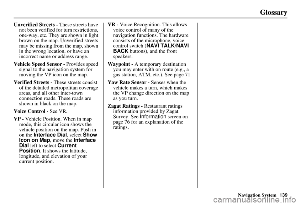
Glossary
Unverified Streets - These streets have
not been verified for turn restrictions,
one-way, etc. They are shown in light
brown on the map. Unverified streets
may be missing from the map, shown
in the wrong location, or have an
incorrect name or address range.
Vehicle Speed Sensor - Provides speed
signal to the navigation system for
moving the VP icon on the map.
Verified Streets - These streets consist
of the detailed metropolitan coverage
areas, and all other inter-town
connection roads. These roads are
shown in black on the map.
Voice Control - See VR.
VP - Vehicle Position. When in map
mode, this circular icon shows the
vehicle position on the map. Push in
on the Interface Dial , select Show
Icon on Map , move the Interface
Dial left to select Current
Position . It shows the latitude,
longitude, and elevation of your
current position. VR -
Voice Recognition. This allows
voice control of many of the
navigation functions. The hardware
consists of the microphone, voice
control switch ( NAVI TALK/NAVI
BACK buttons), and the front
speakers.
Waypoint - A temporary destination
you may enter with on route (e.g., a
gas station, ATM, etc.). See page 71.
Yaw Rate Sensor - Senses when the
vehicle makes a turn, which makes
the VP change direction on the map
as you turn.
Zagat Ratings - Restaurant ratings information prov ided by Zagat
Survey. See Information screen on
page 76 for an explanation of the
ratings.
Page 142 of 166

Navigation System141
Voice Command Index
Voice command help
How long to the destination? (when
on route, tells the time to
destination)*
How far to the destination? (when on
route, tells the distance to
destination)*
Display destination map (when on
route, shows the map of the
destination)
Display entire route (when on route,
adjusts the map scale so that the
entire route is displayed)
Display current location (shows
current latitude, longitude, and
elevation)
Register the current location (puts current location in the personal
Address Book)
Display traffic incidents (or Display
traffic list )
* These commands ar e not available if
you scroll the map while on route to
a destination.Navigation Display
Commands
The system accepts these commands on
a map/guidance screen.
Display current location
Display north up
Display heading up
Display zoom in
Display zoom out
Display: (the selected scale)
1/20 mile (80 m) scale
1/8 mile (200 m) scale
1/4 mile (400 m) scale
1/2 mile (800 m) scale
1 mile (1600 m) scale
2 mile (3 km) scale
5 mile (8 km) scale
15 mile (24 km) scale
50 mile (80 km) scale
150 mile (240 km) scale
350 mile (560 km) scale
Max zoom in
Max zoom out
Go home
Messages Display:
(display the selected icon on
the screen)
ATM
gas station
restaurant
post office
grocery store
lodging (hotel, motel)
parking garage
parking lot
school
hospital
freeway exit information
Traffic (displays both traffic icons
and speed flow. See page 22)
Traffic speeds (displays the traffic flow bands alongside the road.
See page 22)
Traffic icons (shows traffic icons.
See page 22)
Traffic incidents (displays a list of
traffic incidents. See page 24)