Acura RDX 2014 Navigation Manual
Manufacturer: ACURA, Model Year: 2014, Model line: RDX, Model: Acura RDX 2014Pages: 260, PDF Size: 10.9 MB
Page 111 of 260
110
Map MenuMap Information
Navigation
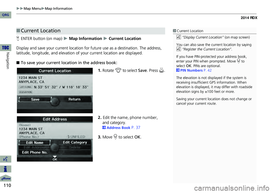
HENTER button (on map) Map Information Current Location
Display and save your current location for fu ture use as a destination. The address,
latitude, longitude, and elevation of your current location are displayed.
■ To save your current loca tion in the address book:
1.Rotate i to select Save . Press u.
2. Edit the nam e, phone num ber,
and category.
2 Address Book P. 37
3. Move r to select OK.
■Current Location1 Current Location
d “Display Current Location” (on map screen)
You can also save the current location by saying
d “Register the Current Location” .
If you have PIN-protec ted your address book,
enter your PIN when prompted. Move r to
select OK. PINs are optional.
2 PIN Numbers P. 42
The elevation is not displayed if the system is
receiving insufficient GPS information. When
elevation is displayed, it may differ with roadside
elevation signs by ±100 feet or more.
Saving your current loca tion does not change or
cancel your current route.
QRG
Page 112 of 260
111
Map MenuMap Information
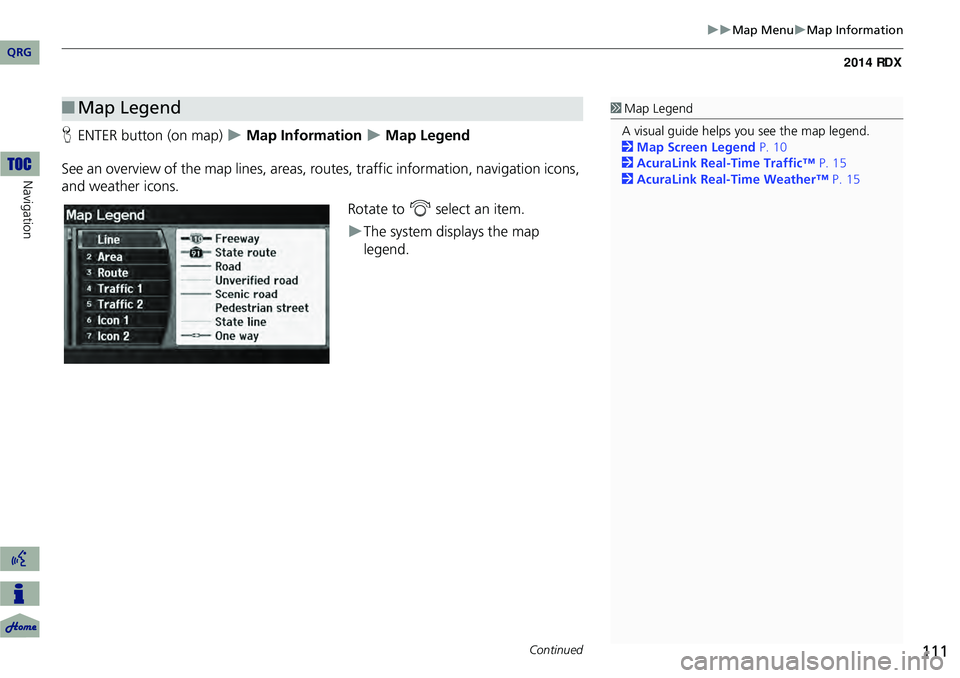
HENTER button (on map) Map Information Map Legend
See an overview of the map lines, areas, ro utes, traffic information, navigation icons,
and weather icons.
Rotate to i select an item.
The system displays the map
legend.
■Map Legend1 Map Legend
A visual guide helps you see the map legend.
2 Map Screen Legend P. 10
2 AcuraLink Real-Time Traffic™ P. 15
2 AcuraLink Real-Time Weather™ P. 15
Continued
QRG
Navigation
Page 113 of 260
112
Map MenuMap Information
Navigation
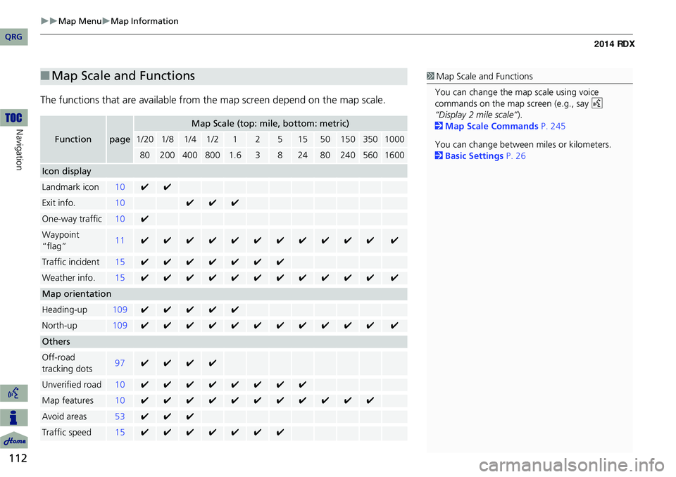
The functions that are available from the map screen depend on the map scale.
■Map Scale and Functions
Functionpage
Map Scale (top: mile, bottom: metric)
1/201/81/41/212515501503501000
802004008001.63824802405601600
Icon display
Landmark icon10✔✔
Exit info.10✔✔✔
One-way traffic10✔
Waypoint
“flag”11✔✔✔✔✔✔✔✔✔✔✔✔
Traffic incident15✔✔✔✔✔✔✔
Weather info.15✔✔✔✔✔✔✔✔✔✔✔✔
Map orientation
Heading-up109✔✔✔✔✔
North-up109✔✔✔✔✔✔✔✔✔✔✔✔
Others
Off-road
tracking dots97✔✔✔✔
Unverified road10✔✔✔✔✔✔✔✔
Map features10✔✔✔✔✔✔✔✔✔✔✔
Avoid areas53✔✔✔
Traffic speed15✔✔✔✔✔✔✔
1 Map Scale and Functions
You can change the map scale using voice
commands on the map screen (e.g., say d
“Display 2 mile scale” ).
2 Map Scale Commands P. 245
You can change between miles or kilometers.
2 Basic Settings P. 26
QRG
Page 114 of 260
113
Map MenuMap Information
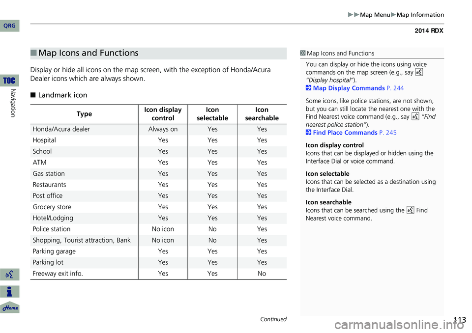
Display or hide all icons on the map screen, with the exception of Honda/Acura
Dealer icons which are always shown.
■ Landmark icon
■Map Icons and Functions
Type Icon display
control Icon
selectable Icon
searchable
Honda/Acura dealerAlways onYesYes
Hospital YesYes Yes
SchoolYesYesYes
ATM YesYes Yes
Gas stationYesYesYes
Restaurants YesYes Yes
Post officeYesYesYes
Grocery store YesYes Yes
Hotel/LodgingYesYesYes
Police station No iconNoYes
Shopping, Tourist attraction, BankNo iconNoYes
Parking garage YesYes Yes
Parking lotYesYesYes
Freeway exit info. YesYes No
1Map Icons and Functions
You can display or hide the icons using voice
commands on the map screen (e.g., say d
“Display hospital” ).
2 Map Display Commands P. 244
Some icons, like police stations, are not shown,
but you can still locate the nearest one with the
Find Nearest voice command (e.g., say d “Find
nearest police station” ).
2 Find Place Commands P. 245
Icon display control
Icons that can be displa yed or hidden using the
Interface Dial or voice command.
Icon selectable
Icons that can be selected as a destination using
the Interface Dial.
Icon searchable
Icons that can be searched using the d Find
Nearest voice command.
Continued
QRG
Navigation
Page 115 of 260

114
Map MenuMap Information
Navigation
■Traffic icon
■ Weather icon
Type Icon display
control Icon
selectable Icon
searchable
Traffic speedYesNoNo
Traffic incident YesNoYes
Type Icon display
control Icon
selectable Icon
searchable
Weather info.YesNoNo
1 Traffic Incident
When you use the Interface Dial to position the
cursor (round red circle) ov er the traffic incident
icon, you can view the summary of the incident.
Press u on the traffic incident icon to view a
pop-up message describing the incident in detail.
QRG
Page 116 of 260
115
Map MenuWeather Information
Weather Information
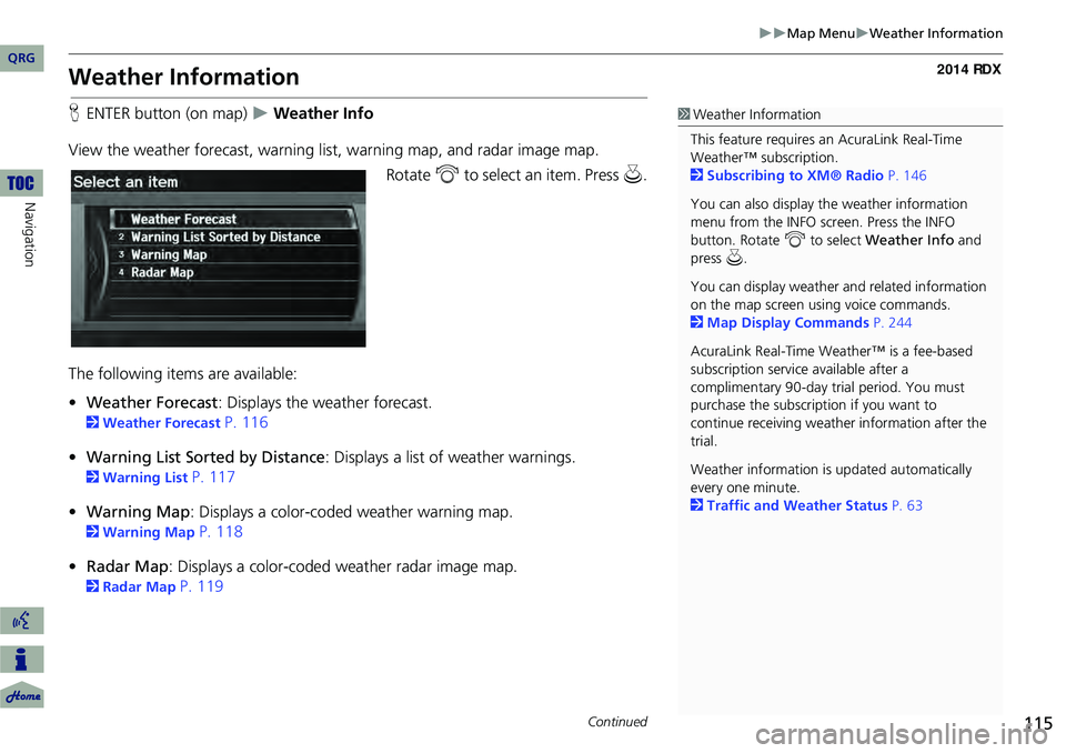
HENTER button (on map) Weather Info
View the weather forecast, warning lis t, warning map, and radar image map.
Rotate i to select an item. Press u.
The following items are available:
• Weather Forecast : Displays the weather forecast.
2Weather Forecast P. 116
• Warning List Sorted by Distance : Displays a list of weather warnings.
2Warning List P. 117
• Warning Map : Displays a color-coded weather warning map.
2Warning Map P. 118
• Radar Map : Displays a color-coded weather radar image map.
2Radar Map P. 119
1Weather Information
This feature requires an AcuraLink Real-Time
Weather™ subscription.
2 Subscribing to XM® Radio P. 146
You can also display the weather information
menu from the INFO screen. Press the INFO
button. Rotate i to select Weather Info and
press u.
You can display weather and related information
on the map screen using voice commands.
2 Map Display Commands P. 244
AcuraLink Real-Time Weather™ is a fee-based
subscription service available after a
complimentary 90-day tr ial period. You must
purchase the subscription if you want to
continue receivi ng weather information after the
trial.
Weather information is updated automatically
every one minute.
2 Traffic and Weather Status P. 63
Continued
QRG
Navigation
Page 117 of 260

116
Map MenuWeather Information
Navigation
HENTER button (on map) Weather Info Weather Forecast
View the weather forecast for your current position or a city you select. 1.Rotate i to select an item.
The following item s are available:
• City Vicinity: Displays the weather forecast for the selected city. You are
prompted to select the city.
2 Selecting a City P. 72
• Current Position : Displays the weather foreca st for your current position.
2. Move w or y to select 1day or
3day to display the 1-day or 3-day
forecast for the location.
■ Weather Forecast1 Weather Forecast
When the GPS signal or weather information
cannot be received, “NA” or “No Data” is
displayed.
You can access the same weather information by
selecting the weather icon for a city on the map
screen.
QRG
Pre ss u .
Page 118 of 260
117
Map MenuWeather Information
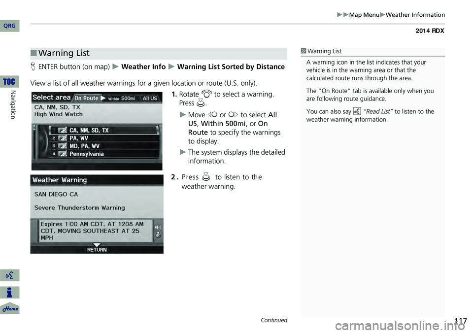
HENTER button (on map) Weather Info Warning List Sorted by Distance
View a list of all weather warnings for a given location or route (U.S. only). 1.Rotate i to select a warning.
Press u.
Move w or y to select All
US , Within 500mi , or On
Route to specify the warnings
to display.
The system displays the detailed
information.
2 . P re ss u to liste n to th e
weather warning.
■ Warning List1 Warning List
A warning icon in the list indicates that your
vehicle is in the warning area or that the
calculated route runs through the area.
The “On Route” tab is available only when you
are following route guidance.
You can also say d “Read List” to listen to the
weather warning information.
Continued
QRG
Navigation
Page 119 of 260
118
Map MenuWeather Information
Navigation
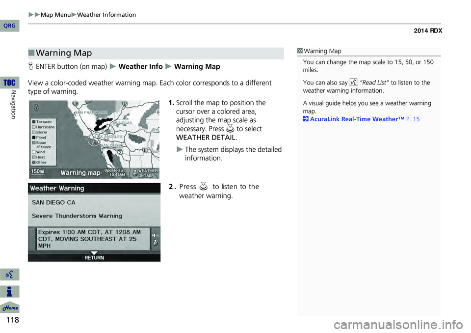
HENTER button (on map) Weather Info Warning Map
View a color-coded weather warning map. Each color corresponds to a different
type of warning.
1.Scroll the map to position the
cursor over a colored area,
adjusting the map scale as
necessary. Press u to select
WEATHER DETAIL .
The system displays the detailed
information.
■Warning Map1 Warning Map
You can change the map scale to 15, 50, or 150
miles.
You can also say d “Read List” to listen to the
weather warning information.
A visual guide helps y ou see a weather warning
map.
2 AcuraLink Real-Time Weather™ P. 15
QRG
2.Pre ss u t o lis te n t o t h e
w eath er w arn in g.
Page 120 of 260
119
Map MenuWeather Information
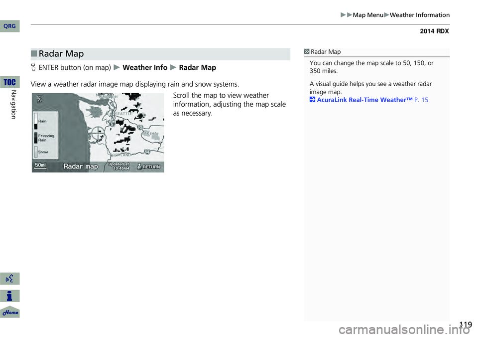
HENTER button (on map) Weather Info Radar Map
View a weather radar image map displaying rain and snow systems. Scroll the map to view weather
information, adjusting the map scale
as necessary.
■ Radar Map1 Radar Map
You can change the map scale to 50, 150, or
350 miles.
A visual guide helps y ou see a weather radar
image map.
2 AcuraLink Real-Time Weather™ P. 15
QRG
Navigation