display AUDI A8 2018 Manual PDF
[x] Cancel search | Manufacturer: AUDI, Model Year: 2018, Model line: A8, Model: AUDI A8 2018Pages: 356, PDF Size: 54.71 MB
Page 168 of 356
Navigation
Navigation
Opening navigation
Applies to: vehicles with navigation system
The navigation system directs you to your desti­
nation , around traffic incidents and on alterna­
tive routes, if desired .
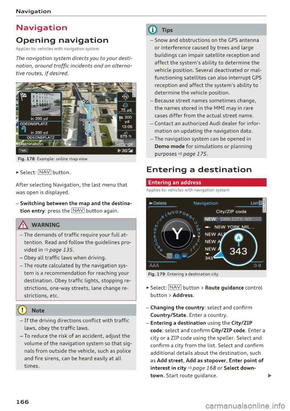
Fig. 178 Example: on lin e map v iew
.. Select : INAVI button.
After selecting Navigation, the last menu that
was ope n is displayed.
- Switching between the map and the destina­
t ion entry:
press the !NAV ! button again.
,&. WARNING
-The demands of traffic require your full at­
tention. Read and follow the guidelines pro­
vided in
i=;,poge 135.
-Obey all traffic laws when driving.
- The route calcu lated by the navigation sys-
tem is a recommendat ion for reaching your
destination. Obey traffic lights, stopping re­
strictions, one-way streets , lan e change re ­
strictions, etc.
@ Note
- If the driving directions conflict with traffic
laws, obey the traffic laws.
- To reduce the risk of an accident, adjust the
volume of the navigation system so that sig­
nals from outside the vehicle, such as police
and fire sirens, can be heard easily at all
times.
166
.
@ Tips
- Snow and obstructions on the GPS antenna
or interference caused by trees and large
buildings can impair satellite reception and
affect the system's ability to determine the
vehicle position. Several deactivated or mal­
functioning satellites can also interrupt GPS reception and affect the system's ability to
determine the vehicle position .
- Because street names somet imes change,
the names stored in the MMI may in rare
cases differ from the actual street name.
- Contact an authorized Audi dealer for infor­
mation on updating the navigation data.
- The navigation system can be opened in
Demo mode for s imulations or plann ing
purposes
re;, page 175.
Entering a destination
Entering an address
Applies to : vehicles with navigat ion system
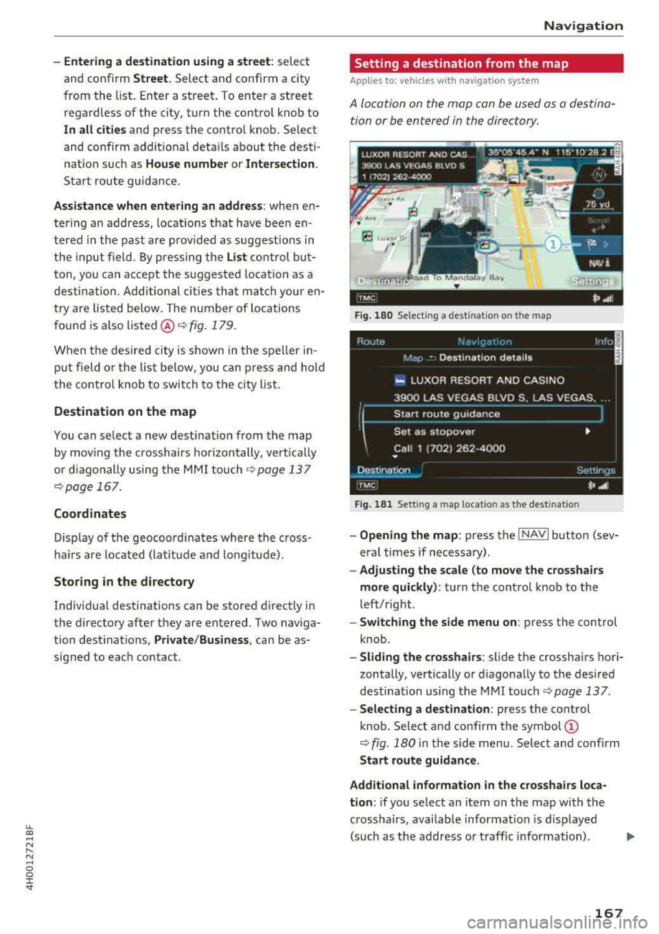
Fig . 179 En ter ing a destina tion city
.. Select: !NAV ! button > Route guidance contro l
button
> Address .
- Changing the country:
select and conf irm
Country/State . Enter a country .
- Entering a destination using the City/ZIP
code:
select and confirm City/ZIP code. Enter a
city or a ZIP code using the spe ller. Select and
confirm a city from the list. Select and confirm
add itional details about the dest ination, such
as
Add street , Add as stopover, Enter point of
interest in
city re;, page 168 or Select down­
town .
Start route guidance.
Page 169 of 356
lL t:0 ....
'"" ......
'"" .... 0 0 :c '
and confirm
Street. Select and confirm a city
from the list. Enter a street . T o enter a street
regardless of the city, turn the contro l knob to
In
all cities and press the control knob . Se lect
and confirm additional details about the desti ­
nation such as
House number or Intersection.
Start route guidance .
Assistance when entering an address: when en­
tering an address, locations that have been en ­
tered in the past are prov ided as suggestions in
the input field . By press ing the
List control but­
ton, you can accept the suggested loca tion as a
destination. Additional cities that match your en­
try are listed below. The number of locations
found is also
listed @¬Ę fig. 179.
When the des ired city is shown in the spe ller in­
put field or the list below, you can press and hold
the control knob to switch to the city list.
Destination on the map
You can se lect a new destination from the map
by mov ing the crosshairs horizontally, vertically
or diagonally using the MMI touch
¬Ę page 137
¬Ępage 167.
Coordinates
Display of the geocoord inates where the cross ­
hairs are located (latitude and longitude).
Storing in the directory
Individual destinations can be stored d irect ly in
the directory after they are entered. Two naviga­
tion destinations,
Private /Business , can be as­
signed to each contact .
Navigation
Setting a destination from the map
A pp lies to : vehicles wi th navigat ion syste m
A location on the map can be used as a destina­
tion or be entered in the directory.
E Lu‚ÄĘo, O,
1·
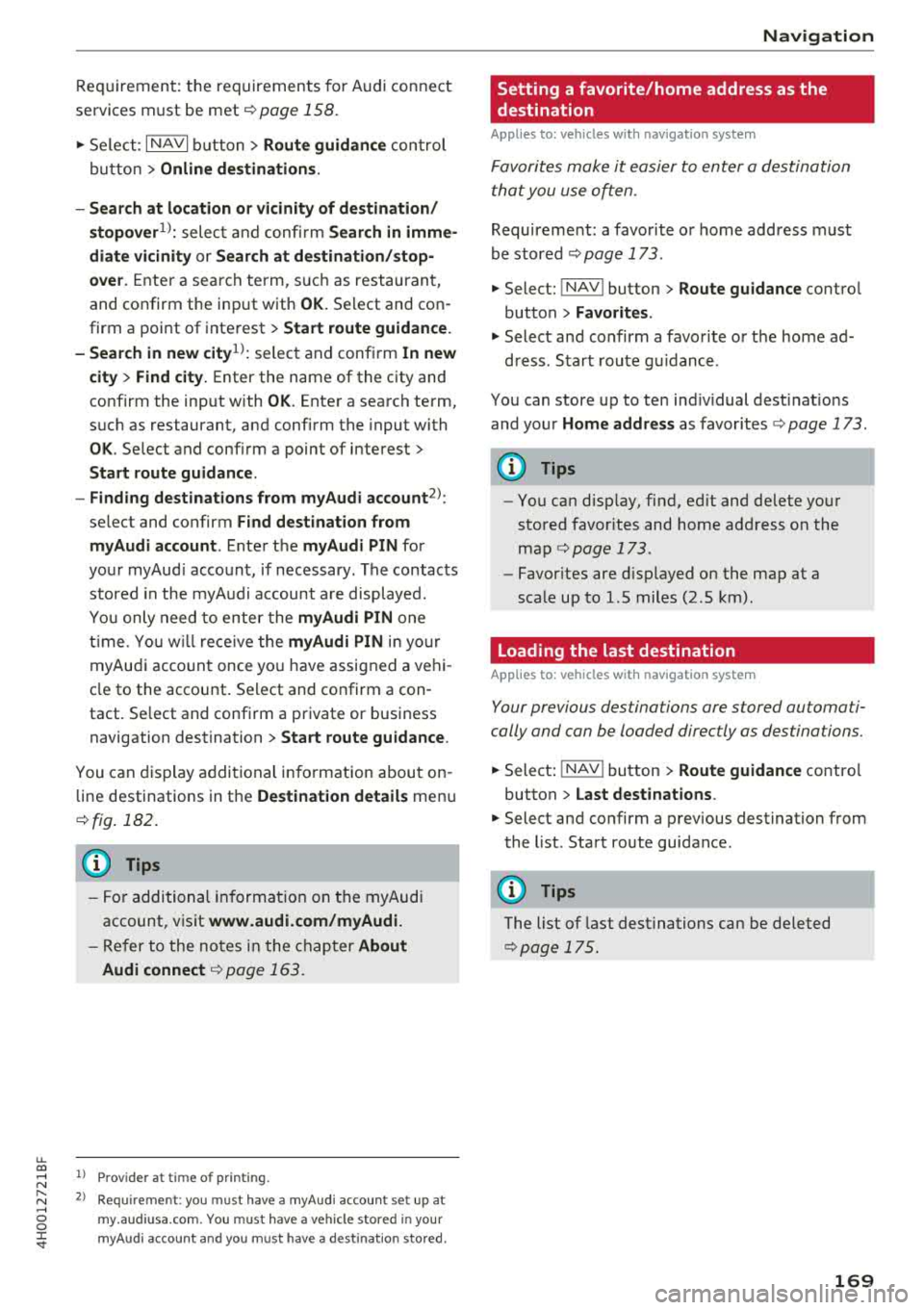
Fig. 180 Select ing a destination on t he map
Fig . 181 Sett ing a ma p locatio n as the destinat ion
- Opening the map : press the I NAVI button (sev­
eral times if necessary).
- Adjusting the scale (to move the crosshairs
more quickly) :
turn the control knob to the
left/right .
-Switching the side menu on : press the control
knob .
-Sliding the crosshairs : slide the crosshairs hori­
zontally, vertically or diagonally to the desired
destination using the MMI
touch¬Ę page 137.
-Selecting a destination: press the control
knob . Select and confirm the
symbol @
¬Ę fig. 180 in the side menu. Select and confirm
Start route guidance .
Additional information
in the crosshairs loca­
tion :
if you select an item on the map with the
crosshairs, available information is d isp layed
(such as the address or traffic information) .
167
Page 171 of 356
u. co .... N
" N .... 0 0 :c '
services must be met¬Ę
page 158.
.,. Select : I NAVI button> Route guidance control
button >
Online destinations.
- Search at location or vicinity of destination/
stopover
1> : select and confirm Search in imme­
diate vicinity or Search at destination/stop­
over.
Enter a search term, s uch as restaurant,
and confirm the inp ut with
OK. Select and con­
firm a point of interest>
Start route guidance.
- Search in new
city l): select and confirm In new
city > Find city.
Enter the name of the city and
confirm the input with
OK . Enter a search term,
such as restaurant, and confirm the input with
OK . Select and confirm a point of interest>
Start route guidance.
- Finding destinations from myAudi account
2>:
select and confirm Find destination from
myAudi account .
Enter the myAudi PIN for
your myAud i account, if necessary . The contacts
stored in the myAudi account a re displayed.
You only need to enter the
myAudi PIN one
time . You will rece ive the
myAudi PIN in yo ur
myAudi account once you have assigned a vehi­
cle to the account. Select and confirm a con ­
tact. Se lect and confirm a private or business
navigation destination >
Start route guidance .
You can display additional information about on­
line destinations in the
Destination details menu
¬Ęfig . 182.
(D Tips
- For additional information on the myAudi
account, visit
www .audi.com/myAudi.
- Refer to the notes in the chapter About
Audi connect
¬Ę page 163.
1> Prov ider at time of printing .
2> Requ irement : yo u must have a m yAudi account set up at
my .audiusa .com. You must have a vehicle stored in your
my Audi accou nt and you must have a destinat io n sto red .
Navigation
Setting a favorite/home address as the
destination
Applies to : vehicles wi th navigat ion syste m
Favorites make it easier to enter a destination
that you use often.
Requirement: a favorite or home address must
be stored ¬Ę
page 173.
.,. Select: !NAV ! button> Route guidance contro l
button >
Favorites.
.,. Select and confirm a favorite or t he home ad-
dress . Start route g uidance .
You can store up to ten ind iv idual desti nat ions
and your
Home address as favorites ¬Ę page 173.
(D Tips
- You can disp lay, find, ed it and delete your
stored favorites and home address on the
map
¬Ę page 173.
- Favor ites are displayed on the map at a
scale up to l.S miles (2.S km) .
Loading the last destination
Applies to: vehicles wit h navigat ion system
Your previous destinations are stored automati­
cally and can be loaded directly as destinations.
.,. Select: ! NAV ! button> Route guidance contro l
button >
Last destinations .
.,. Select and confirm a previous destination from
the list. Start route guidance .
(D Tips
The list of last destinations can be deleted
¬Ępag e 175.
169
Page 173 of 356
lL t:0 ,..,
"" ......
"" ,..,
0 0 :c '
guidance
Applies to: ve hicles with navigation system
You can a lso cancel route guidance by enter ing a
new destination
¬Ę page 166 .
-Starting route guidance when entering a new
destination :
select the I NAVI button > Route
guidance
control button > Enter a des tination
> Start route guidance .
- Restarting/canceling last route guidance :
se­
lect the
I NAVI but ton> Route guidance control
button
> Start /Cance l.
The fo llow ing additional functions are ava ilable
when enter ing a new destination:
Display alternative routes: three route s ugges ­
tions are calcu lated for the destination that is
currently entered. The side menu shows informa­
tion about the alternative routes , such as dis­
tance to the dest inat ion and the calculated arriv­
a l time .
Alternat ive routes can only be calcu lated for indi­
vidual destinations .
Enter point of interest in city : allows you to
search for attractions and public places around
the specified locat ion, such as hospitals , mov ie
theaters , recreation areas, etc. The po ints of in­
terest can be selected direct ly as a destination.
Select downtown : the navigation system ca lcu ­
l ates the ro ute to the center of the city or distr ict
that is entered .
Display destination on map : the destination en­
tered is disp layed on the map.
1l O nly appl ies to vehicles w ithou t camer a-based speed lim it
d isp lay .
Navigation
Operating the map
Appl ies to: vehicles with navigation system
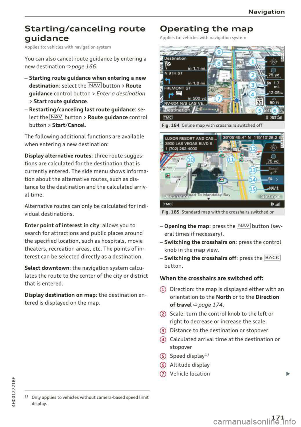
Fig. 184 Online map wit h crossha irs sw itched off
Fig. 185 Standard map wit h the c ross hair s sw itched o n
-Opening the map : press the I NAVI button (sev­
eral times if necessary).
- Switching the crosshairs on: press the contro l
knob in the map view.
- Switching the crosshairs off: press the I BACK I
button.
When the crosshairs are switched off:
(D Direction : the map is displayed eith er with an
orientation to the
North or to the Direction
of
travel ¬Ę page 174.
@ Scale: turn the control knob to the left or
right to decrease or increase the scale .
@ Distance to the destination or stopover
@ Calcu lated arriva l time at the destination or
stopover
¬ģ Speed display1l
¬ģ Altitude d isp lay
(J) Vehicle location
171
Page 174 of 356
Navigation
@ Display of selected map information
¬ģ Display of an upcoming maneuver
When the crosshairs are switched on:
@ Information regarding the location of the
crosshairs: If you select a city on the map us­
ing the crosshairs, any information available
is displayed, such as address, phone number
or traffic information.
@ Map content, such as traffic information, fa­
vorites or points of interest
@ Display of the geocoordinates where the
crosshairs are located (latitude and longi­
tude)
@ Moving along the route: This function can be
used while route gu idance is active. Turn the
control knob to the left or right to move the
map along the current route.
~ Destination details menu : Display of availa ­
ble details about the location of the cross­
hairs, such as address. The location of the
crossha irs can be used as a stopover, stored
in the directory or called
¬Ę page 166.
@ Repeat the last navigation message
If you select the map orientation
(I) and press
the control knob when the side menu is switched
on and the
20 map v iew is selected ¬Ę page 174,
the display switches from Dir. of travel to North
and vice versa. This setting is saved.
Online map view
Applies to: vehicles w ith navigation system and Audi connect
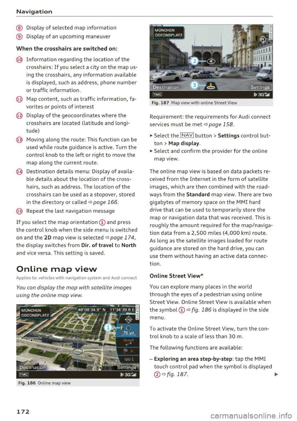
You can display the map with satellite images
using the online map view.
F ig . 186 Online map v iew
172
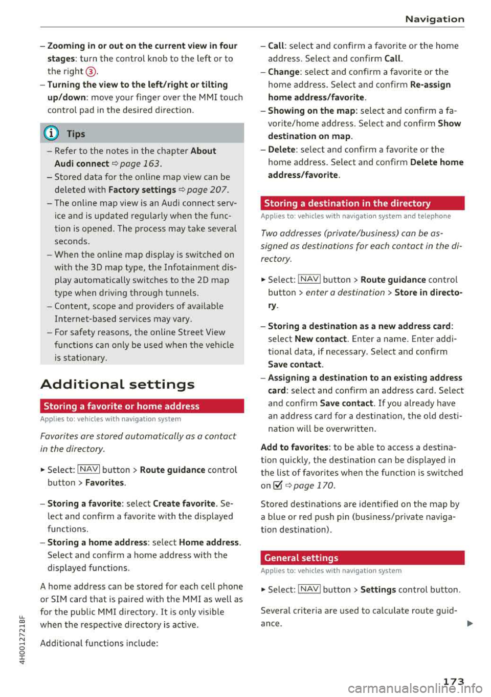
Fig. 187 Map view w ith o nline Street View
Requirement: the requirements for Audi connect
services must be met
¬Ępage 158.
.,.. Select the I NAVI button> Settings control but­
ton > Map display .
.,.. Select and confirm the provider for the online
map
v iew .
The online map view is based on data packets re­
ceived from the Internet in the form of satellite
i mages, which are then combined w ith the road­
ways from the Standard map view. There are two
gigabytes of memory space on the MMI hard
drive that can be used to temporari ly store the
map or navigation data that was received. This is
roughly the amount required for the map/naviga­
tion data from a 2,500 miles (4,000 km) route .
As long as the satell ite images loaded for route
guidance are sto red on the hard drive, you can
use them without having an active data connec­
tion.
Online Street View*
You can explore many places in the world
through the eyes of a pedestrian using on line
Street View . Online Street View is available when
the symbol
(D ¬Ę fig. 186 is displayed in the side
menu.
To activate the Online Street View, turn the con­
trol knob to a scale of less than 30 m .
The following functions are available:
-Exploring an area step-by-step: tap the MMI
touch control pad when the symbol is disp layed
@ ¬Ęfig.187. ..,.
Page 175 of 356
u. co .... N
" N .... 0 0 :c '
stages:
turn the contro l knob to the left or to
the
right @.
-Turning the view to the left/right or tilting
up/down :
move your finger over the MMI touc h
contro l pad in the desired direction.
(D Tips
-Refer to the notes in the chapter About
Audi connect
¬Ę page 163.
- Stored data for the on lin e map view can be
deleted with
Factory settings ¬Ę page 207.
- The online map view is an Audi connect serv­
ice and is updated regularly when the func ­
tion is opened. The process may take several
seconds.
- When the on line map display is switched on
with the
3D map type, t he Infotainment dis­
play automatically switches to the
2D map
type when dr iv ing through tunnels.
- Content, scope and providers of availab le
Internet-based se rvices may vary.
- For safety reasons, the online Street View
funct ions can on ly be used when th e vehicle
i s stat ionary.
Additional settings
Storing a favorite or home address
Applies to : vehicles with navigation system
Favorites are stored automatically as a contact
in the directory .
.,. Select: I NAVI button> Route guidance control
button >
Favorites .
- Storing a favorite:
select Create favorite . Se­
lect and confirm a favorite with the displayed
functions.
- Storing a home address : select Home address .
Select and confirm a home address with the
displayed functions.
A home address can be stored for each cell phone
or SIM card that is paired with the
MMI as well as
for the public MMI directory . It is only visible
when the respective directory is active .
Addit ional functions include:
Navigation
- Call :
select and confirm a favorite or the home
address. Se lect and confirm
Call.
- Change:
se lect and confirm a favorite or the
home address. Select and confirm
Re-assign
home address/favorite.
- Showing on the map:
select and confirm a fa­
vorite/home address. Se lect and confirm
Show
destination on map.
- Delete :
select and confirm a favorite or the
home address. Se lect and confirm
Delete home
address/favorite .
Storing a destination in the directory
Applies to : vehicles wit h nav igation system and telep hone
Two addresses (private/business) can be as­
signed as destinations for each contact in the di­
rectory.
.. Select: I NAV ! button> Route guidance control
button >
enter a destination > Store in directo­
ry .
- Storing a destination as a new address card :
select New contact. Enter a name. Enter addi ­
tional data, if necessary. Select and confirm
Save contact .
- Assigning a destination to an existing address
card:
select and confi rm an address card. Select
and confirm
Save contact. If you already have
an address card for a destination, the old desti­
nation will be overwritten .
Add to favorites : to be able to access a destina­
t ion quickly, the destination can be displayed in
the list of favorites when the function is switched
on~ ¬Ę page 170 .
Stored destinations are identified on the map by
a b lue or red push pin (bus iness/private naviga­
tion destination) .
General settings
Applies to: vehicles with navigation system
.. Select: INAV ! button> Settings control button .
Several criter ia are used to calculate route guid-
ance.
1J1,,
173
Page 176 of 356
Navigation
Route criteria
Auto rerouting (traffic):
when auto rerouting is
On, the route is automatically adjusted based on
TMC traffic information . If the MMI does not cal­
culate a detour even though you have se lected
dynamic route
On and a traffic jam was reported
on the calculated route, then the detour the sys­
tem calculated would take more time than the
time spent wa iting in the traffic jam.
Alternative routes : when the function is On, up
to three suggested routes and their criteria ap­
pear in the Infotainment d isplay in the s ide
menu . After chang ing to map view, the new route
that was calculated according to your criteria is
h ighlighted. You can select the poss ible routing
in the alternative routes by turning and press ing
t he control knob.
Route type: you can select a Short , Fast or Mixed
route.
Highway /Toll roads/Ferry: select the Avoid op­
tion you do not want the navigation system to in­
clude highways, toll roads or ferr ies when ca lcu­
lating
a route.
Time restricted roads : using the Avoid function
w ill exclude time restricted roads, such as pedes­
trian zones, from the route calcu lation. Whe n
Auto is selected, the MMI decides if the time re­
stricted roads should be included when calculat­
ing the route guidance based on the e ntries stor ­
ed in the navigation data.
Seasonal closing: using the Avoid function w ill
ex clud e seasona l closings, such as mountain
passes, from the route calculation . When
Auto is
selected, t he
MMI decides if the seasona l re ­
stricted roads should be included when calcu lat ­
ing the route guidance based on the entries stor ­
ed in the navigation data.
Map colors
Day /Night :
the map is displayed with a light/
dark background.
Auto : when t he lig hts switch on, the map colors
sw itch from day to night.
1> Only possible in the 2D map v iew
174
Orientation
North 1
l: the map orientation is facing nort h.
Dir. of travel : the map orientation is in the direc­
t ion of travel. At a sca le of 62 miles (100 km),
t h e map is or iented to the north for easie r orien­
tation.
Auto: at a scale up to 3 m iles (5 km), the map
o rientation is in the direction of travel. At a scale
greate r than 3 miles (5 km), the map is or iented
to the north.
Map type
Destination :
the destination is marked with a
checke red flag. The map indicates the destina­
t ion and is oriented to the north.
2D: the current veh icle posit ion is displayed. The
map or ientation corresponds to the sett ing in the
Map orientation menu ~ page 174 .
3D: when th is function is switched on, the cur­
rent vehicle position is displayed in a three-di­
mens ional terrain map and the map or ientat ion
i s set automatically to the
Dir. of travel. At a
sca le of 100 km and larger, the map is oriented
to th e north . At a scale between 30
-100 meters,
the display will show three-dimensional city
models and landmarks will be shown at a scale of
30
-200 meters.
Overview : the entire route from the vehicle loca­
tion to the destination is d isp layed on the map.
The map scale depends on the length of the
route. The map is oriented to the north.
Map display
Online map view ~ page 172
Map content
Map contents such as traffic information, favor­
i tes or restaurants can be displayed
(~) or hid ­
den .
The functions in the
Map POis menu depend on
the map display that is selected.
IJIJ,
Page 177 of 356
u. co .... N
" N .... 0 0 :c '
When t he f unction is switc hed On , the three up ­
coming turns and the calc ulated distance and ar ­
rival tim e are shown in th e Infota inm ent disp lay
dur ing route gu idanc e@
¬Ę pag e 171 , fig. 184 .
The cu rrent s treet t raveled, upcoming maneu ­
ve rs, traffic information or points of interes t on
the current ro ute are a lso displayed.
The next tu rn is d isp layed at the bottom of the
tab le.
Automatic zoom
On : the map scale is adapted automat ically de ­
pending on t he type of road being traveled on
(expressway, h ighway , other roads) so t hat you
a lways have an optimal overv iew of the road
a h ead . When there are upcom ing ma neuvers, t he
scale is automatically reduced to prov ide a better
detai led view.
Inter section : when ro ut e g uidance is active, t he
map temporarily zooms in to a detailed scale
when there are upcoming mane uvers so that you
can see the route better .
Off: the map sca le yo u have chosen is kept in­
stead.
Gas station message
When th is function is sw itched On , a message
appears when t he fue l gauge goes below the re­
serve mar king. Conf irming th is message displays
a list of gas stations in the area. When a gas s ta ­
tion is se lected, route g uidance from the c urrent
ve hicle position is calc ulated .
Speed limit display *l)
The max imum speed limits for expressways ,
hi ghways and ma in streets can be switched
On -/
Off if they are stored in the navig ation da ta .
Voice guidance
The vo ice gu idance prompts can be Complete or
Shortened . When Off is selected , no vo ice gu id­
a n ce is given.
l ) O nly applie s to vehicl es withou t ca mer a-b as ed speed li mit
d is pla y.
Na vigation
Nav igation prompts can be g iven by pressing the
~ button.
Voice guidance on during call
Nav igat ion p rompts can be sw itc hed on ~ or off
dur ing a phone call.
Deleting la st destinations
The destinations you have e ntered last are auto ­
matically stored . T hey ca n be deleted ind iv idually
o r all at once .
Presentation mode
The Demo mode helps you to effective ly plan and
display a route by showing map contents or route
criter ia . You ca n
Set starting point when you
would l ike to calculate a route start ing from a lo­
cat ion other than t he veh icle position. Start
D emo mode to sim ulate the route g uidance.
(D Tips
Fo r safety reasons, the route s imulation in
demo mode is deact ivated while dr iv in g.
Route settings
Applies to: ve hicles w ith navigation system
.,. Select: !NAV ! button> Rout e control butt on.
Route list
The route list is v is ible only when route gu idance
is active and conta ins i nformat ion regard ing the
r oute , the names of the streets a nd the length of
t h e ro ute sect ions. O n longer ro ute sect ions, ad­
di tional info rmat ion may be d isp layed such as
poss ib le i nte rchanges w hen driving on express ­
ways.
Avoid route from here
D ete rmining th e le ngth of the route to b e
avoided :
turn the contro l knob to t he left o r
r ig ht.
When route guida nce is active and the
Standard
map view( ¬Ę page 171) is switched on, the ca lcu¬≠
lated ro ute is avo ided fo r the d istance you have
..,
175
Page 178 of 356
Navigation
specified, if possible. The navigation system cal ­
culates an a lternative route.
The route to be avoided that you ha ve ente red
applies only to the current route and must be set
again, if needed.
The areas you have se lected to avoid w ill appear
with red and white shading on the map.
0) Tips
If the MMI does not calculate an alternative
route, that means there is none available.
Accessing traffic
information
Auto rerouting (traffic)
A pp lies to: ve hicles w ith navigation system an d Sirius (satel ­
li te radi o)
By receiving traffic information from the TMC or
satellite - depend ing on ava ilability -the MMI cal­
culates an optim ized route and the possible t ime
saved for the current route guidance. You can de­
cide yourse lf wh ich route you would like to use.
Traffic information (TMC)
App lies to: ve hicles w ith naviga tion system and Sirius (satel ­
li te ra dio)
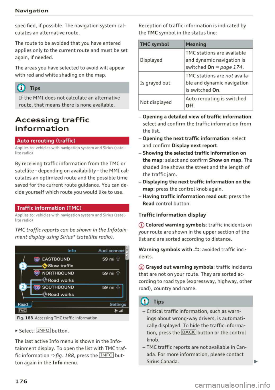
TMC traffic reports can be shown in the Infotain ­
ment display using Sirius* (satellite radio).
Fig. 188 Access ing TMC traff ic informa tion
~ Se lect: IIN FOI button .
The last active Info menu is shown in the Info­
tainment display. To open the list with TMC traf­
fic information
c:tv fig. 188, press the I IN FO I but­
ton again in the
Info menu .
176
Reception of traffic information is indicated by
the
TMC symbol in the status line:
TMC symbol Meaning
TMC stations are avai lable
Displayed and dynamic navigation is
switched
On c:tv page 17 4.
TMC stations are not availa-
Is gra yed o ut ble and dynamic navig ation
i s sw itched
On.
Not disp layed Auto
rerouting is switched
Off.
- Opening a detailed view of traffic information :
select and confirm the traffic information from
the list .
- Opening the next traffic information : select
and confirm
Display next report.
- Showing the selected traffic information on
the map :
select and confirm Show on map . The
shaded line shows the street and the length of
the traff ic jam .
-Displaying the next traffic information on the
map :
press the cont rol knob aga in.
- Having traffic information read out : press the
Read control button.
Traffic information display
@Colored warning symbols: traffic incidents on
your route are shown in the upper sect ion of the
li st and are sorted according to distance.
Warning symbols with.::->: avoided traffic inci­
dents.
@ Grayed out warning symbols: traffic incidents
that are not on your route. They are sorted ac ­
cording to road type (expressway, highway, other
road), country and name.
(D Tips
-Critical traffic information, s uch as warn ­
ings about wrong -way drivers, is automati­
cally disp layed. To hide the traffic informa­
t ion, press the
I BACK I button or the control
knob.
- TMC traffic reports are not available in Can­
ada. For more information, please contact
S ir ius Canada .
Page 179 of 356
u. co .... N
" N .... 0 0 :c '
mation system disp lay and can be selected
by turning the left thumbwheel.
Other settings
~ Select : IINFO I button> Settings control button .
Traffic report
Traffic informati on that refers to an active desti­
nation is given as a spoken announcement when
t he function is sw itched
On.
Troubleshooting
Applies to: vehicles with navigation system
Problem Solution Navigation
Music volume during nav. prompts
T urn the On/Off knob to the rig ht or l eft to the
adjust the vol ume during traffic reports .
Favorites that were a lready stor -
The favorites in th e pub lic MMI directory are visible for a ll users in
ed are no longer displayed.
the vehicle.
If a cell phone is connected, both the favorites from the private
d irectory and the favorites stored as public are displayed.
If you want to make a favorite available for al l users, it must be
stored in the public MM I directory. A favorite in the pr ivate di rec-
tory must be marked as one of the
Shared contacts if you want it
to be ava ilable for a ll users .
177