navigation DODGE JOURNEY 2020 User Guide
[x] Cancel search | Manufacturer: DODGE, Model Year: 2020, Model line: JOURNEY, Model: DODGE JOURNEY 2020Pages: 396, PDF Size: 25.53 MB
Page 343 of 396
MULTIMEDIA 341
Using The On-Screen Buttons
Press and hold to quickly return to the
main menu.
Press and to see more choices.
Press and hold and to scroll faster.
Finding A Point Of Interest
The detailed maps loaded in your navigation
s y
stem contain points of interest, such as
restaurants, hotels and auto services.
1. Fr om the main menu, press
W
here To? >
Points of Interest
.
2. S elect a category.
3
. I f necessary, select a subcategory.
4
. S elect a destination.
5
. P ress Go!
F
inding A Location By Spelling The Name
1. Fr om the main menu, press
W
here To? >
Points of Interest > Spell Name
.
2. E nter all or part of the name.
3
. P ress Done . 4
. S
elect a destination.
5
. P ress Go!
U
sing The On-screen Keyboard
Press a character on the keyboard to enter a
letter or number.
Press “Space” to add a space.
Press to delete a character.
Press and hold to erase the entire entry.
Press to select the keyboard language
mode.
Press to enter special characters, such as
punctuation marks.
Adding Points To The Active Route
1. W hile navigating a route, press
to return
to the main menu.
2. F rom the main menu, press W
here To?
3. S elect a category.
4
. I f necessary, select a subcategory.
5
. S elect a destination. 6
. P
ress Go!
7
. P ress Add as a Via Point .
C
hanging The Destination Of The Active Route
Before you can change destinations you must
b e
navigating a route.
1. P ress
to return to the main menu.
2. P ress Where To?
3
. S earch for the location.
4
. P ress Go!
5
. P ress Set as a New Destination .
T
aking A Detour
While navigating a route, you can use detours to
a v
oid obstacles ahead of you, such as
construction zones.
NOTE:
If the route you are currently taking is the only
re
asonable option, the navigation system might
not calculate a detour.
1. W hile navigating a route, press .
2
. F rom the main menu, press D
etour.
9
Page 344 of 396
342 MULTIMEDIA
Stopping The Route
1. While navigating a route, press .
2
. F rom the main menu, press S
top.
Finding Locations
The Where To? menu provides several different
categories you can use to search for locations.
To perform a simple search, see the “Getting
Started” section.
Finding An Address
NOTE:
Depending on the version of the built-in map
d a
ta on your navigation system, the button
names and the order of steps could be different
than the steps below.
1. From the main menu, press
W
here To? >
Address
.
2. I f necessary, change the state, the country,
o
r the province.
3. P ress Spell City .
4
. E nter the city/postal code. N
OTE:
If you are unsure of the city/postal code, press
S e
arch All .
5. P ress Done .
6
. I f necessary, select the city/postal code.
N
OTE:
Not all map data provides postal code
s e
arching.
7. E nter the number of the address.
8
. P ress Done .
9
. E nter the street name.
1
0. P ress Done .
1
1. I f necessary, select the street.
1
2. I f necessary, select the address. U
sing The Go! Page
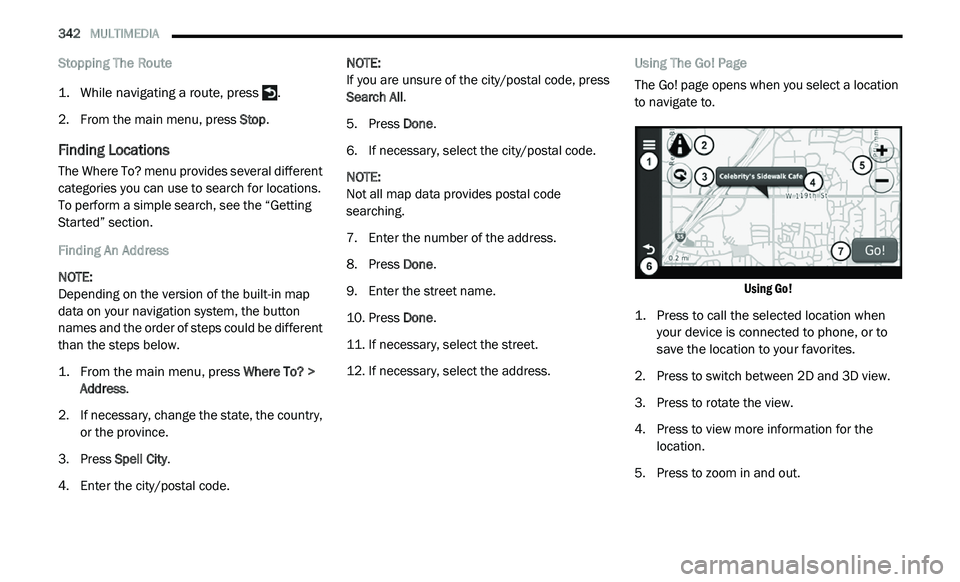
The Go! page opens when you select a location
t o
navigate to.
Using Go!
1. P ress to call the selected location when
y
our device is connected to phone, or to
save the location to your favorites.
2. P ress to switch between 2D and 3D view.
3
. P ress to rotate the view.
4
. P ress to view more information for the
l
ocation.
5. P ress to zoom in and out.
Page 345 of 396
MULTIMEDIA 343
6. Press to return to the previous page. Press
and hold to return to the main menu.
7. P ress to create a turn-by-turn route to this
l
ocation.
Setting A Home Location
You can set your home location for the location
yo
u return to most often.
1. Fr om the main menu, press
W
here
To? > Go Home
.
2. S elect Enter M
y Address, Use My Current
Location or Recently Found .
Going Home
Before you can navigate to home you must set
a
home location.
From the main menu, press Where To? > Go
Home .
Resetting Your Home Location
1. F rom the main menu, press
W
here To? > > Set Home Location
.
2. S elect an option to change your address. E
diting Your Home Location Information
1. Fr om the main menu, press
W
here
To? > Favorites > Home
.
2. P ress
> Edit.
3. E nter your changes.
4
. P ress Done .
V
iewing A List Of Recently Found Locations
Your navigation system stores the last
50 locations you have found.
From the main menu, press Where
To? > Recently Found .
Clearing The List Of Recently Found Locations
From the main menu, press Wh
ere To? >
Recently Found > > Clear > Yes.
About Favorites
You can save locations in your Favorites so you
c a
n quickly find them and create routes to
them. Your home location is also stored in
Favorites. Saving Your Current Location To Favorites
1. Fr
om the map, press the vehicle icon.
2
. P ress Save .
3
. E nter a name.
4
. P ress Done .
T
he location is saved in Fa
vorites.
Saving Locations To Favorites
1. Search for the location.
2
. From the Go! page, press
> Save > OK.
Finding Favorites
1. Fr om the main menu, press
W
here
To? > Favorites
.
2. I f necessary, select a category.
3
. S elect a saved location.
E
diting Favorites
1. Fr om the main menu, press
W
here
To? > Favorites
.
2. S elect a category.
9
Page 347 of 396
MULTIMEDIA 345
Browsing The Map By Pressing The
Touchscreen
Press an area on the map to select a location.
An information box appears next to the location.
Press and drag the map to view different
parts of the map.
Press the map twice to zoom in and center on
a location.
Finding A Location Using The Map
1. Fr om the main menu, press
W
here
To? > Browse Map
.
2. P ress a location.
A
n information box appears next to the location.
3. Press the information box.
4
. S elect an option:
Press > Save.
5. P ress Go!
S
etting A Simulated Location
You can use the GPS simulator to select another
l o
cation, near which you can search for and save points of interest. This may be helpful
when planning trips.
1. Fr
om the main menu, press
T
ools >
Settings > System > GPS Simulator > On
.
2. F rom the main menu, press W
here
To? > Browse Map .
3. P ress an area on the map.
4
. Press
> Set Location .
Entering Coordinates
If you know the geographic coordinates of your
d e
stination, you can use your navigation system
to navigate to the destination using the latitude
and longitude coordinates.
1. From the main menu, press
W
here
To? > Coordinates
.
2. P ress a field to enter the latitude and
l
ongitude data.
3. P ress View on Map .
4
. P ress Go! C
hanging The Map Coordinate Format
1. Fr om the Home Screen, press
W
here
To? > Coordinates > > Format
.
2. S elect a format.
Speaking Commands
About Voice Commands
NOTE:
The voice command feature is not available for
a l
l languages or regions.
The voice commands allow you to use your
n a
vigation system by speaking the words you
see on the screen or by speaking certain
commands.
Activating Voice Command
Press the Voice Recognition button.
The navigation system enters voice
command.9
Page 348 of 396
346 MULTIMEDIA
About Icons And Tones
The navigation system sounds two tones
when it enters and exits voice recognition
mode.
A red icon appears in the upper-right
corner of the screen when the navigation
s y
stem is not ready for your command.
Wait until the icon is green to speak your
command.
Tips for Using Voice Commands
Speak in a normal voice directed at the navi -
gation system.
Speak commands as they appear on the
screen.
Respond to voice prompts from the naviga -
tion system as needed.
Speak “Exit” to exit voice command. Navigating To A Popular Location Using Voice
C
o
mmands
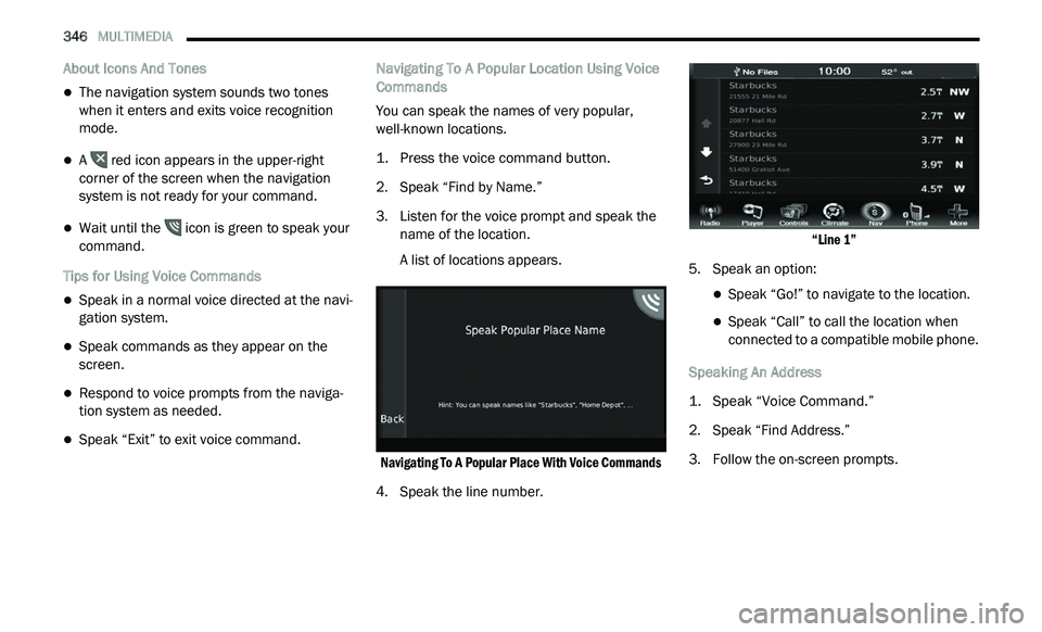
You can speak the names of very popular,
w e
ll-known locations.
1. P ress the voice command button.
2
. S peak “Find by Name.”
3
. Li sten for the voice prompt and speak the
n
ame of the location.
A list of locations appears.
Navigating To A Popular Place With Voice Commands
4. Speak the line number.
“
Line 1”
5. S peak an option:
Speak “Go!” to navigate to the location.
Speak “Call” to call the location when
connected to a compatible mobile phone.
Speaking An Address
1. S peak “Voice Command.”
2
. S peak “Find Address.”
3
. F ollow the on-screen prompts.
Page 349 of 396
MULTIMEDIA 347
About The Map Pages
Viewing The Map While Navigating
NOTICE
In no event shall Garmin® be liable for any
in
cidental, special, indirect, or consequential
damages, including, without limitation,
damages for any traffic fines or citations,
whether resulting from the use, misuse, or
inability to use the product or from defects in
the product. Some states do not allow the
exclusion of incidental or consequential
damages, so the above limitations may not
apply to you.
Your route is marked with a magenta line.
A checkered flag marks your destination.
As you travel, your navigation system guides you
t o
your destination with voice prompts, arrows
on the map, and directions at the top of the
map. If you depart from the original route, your
navigation system recalculates the route and
provides new directions.
A speed limit icon displaying the current speed
l i
mit may appear as you travel on major
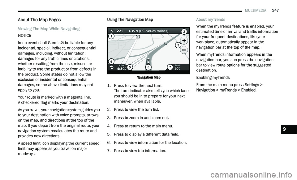
roadways. Using The Navigation Map
Navigation Map
1. P ress to view the next turn.
T
he turn indicator also tells you which lane
y o
u should be in to prepare for your next
maneuver, when available.
2. P ress to view the turn list.
3
. P ress to zoom in and zoom out.
4
. P ress to return to the main menu.
5
. P ress to display a different data field.
6
. P ress to view information for the location.
7
. P ress to view trip information. A
bout myTrends
When the myTrends feature is enabled, your
e s
timated time of arrival and traffic information
for your frequent destinations, like your
workplace, automatically appear in the
navigation bar at the top of the map.
When myTrends information appears in the
na
vigation bar, you can press the navigation
bar to view route options for the suggested
d e
stination.
Enabling myTrends
From the main menu press Se
ttings >
Navigation > myTrends > Enabled .
9
Page 350 of 396
348 MULTIMEDIA
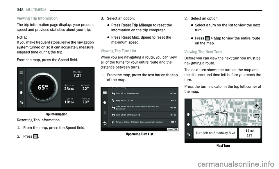
Viewing Trip Information
The trip information page displays your present
sp
eed and provides statistics about your trip.
NOTE:
If you make frequent stops, leave the navigation
s y
stem turned on so it can accurately measure
elapsed time during the trip.
From the map, press the Sp
eed field.
Trip Information
Resetting Trip Information
1. Fr om the map, press the
S
peed
field.
2. Press . 3
. S
elect an option:
Press Reset Trip Mileage to reset the
information on the trip computer.
Press Reset Max. Speed to reset the
maximum speed.
Viewing The Turn List
When you are navigating a route, you can view
al
l of the turns for your entire route and the
distance between turns.
1. Fr om the map, press the text bar on the top
o
f the map.
Upcoming Turn List
2. S
elect an option:
Select a turn on the list to view the next
turn.
Press > Map to view the entire route
o
n the map.
Viewing The Next Turn
Before you can view the next turn you must be
n a
vigating a route.
The next turn shows the turn on the map and
t h
e distance and time left before you reach the
turn.
Press the turn indicator in the top left corner of
t h
e map.
Next Turn
Page 351 of 396
MULTIMEDIA 349
Viewing The Junction View
Before you can view the junction view, you must
be
navigating a route.
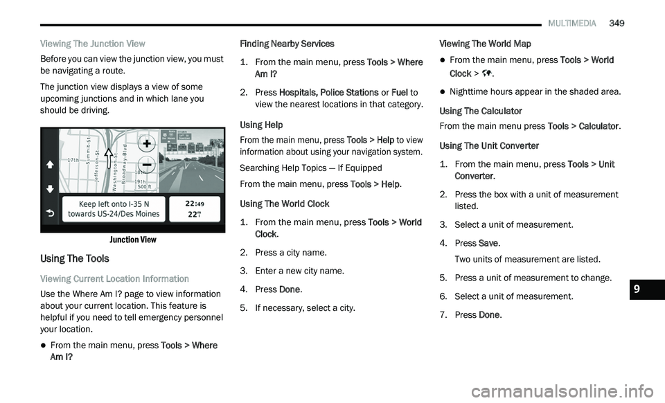
The junction view displays a view of some
u p
coming junctions and in which lane you
should be driving.
Junction View
Using The Tools
Viewing Current Location Information
Use the Where Am I? page to view information
ab
out your current location. This feature is
helpful if you need to tell emergency personnel
your location.
From the main menu, press Tools > Where
Am I? Finding Nearby Services
1. Fr
om the main menu, press
T
ools > Where
Am I?
2. P ress Hospitals, Police Stations
or Fuel to
view the nearest locations in that category.
Using Help
From the main menu, press To
ols > Help to view
information about using your navigation system.
Searching Help Topics — If Equipped
From the main menu, press To
ols > Help.
Using The World Clock
1. From the main menu, press
T
ools > World
Clock
.
2. P ress a city name.
3
. E nter a new city name.
4
. P ress Done .
5
. I f necessary, select a city. V
iewing The World Map
From the main menu, press
Tools > World
Clock > .
Nighttime hours appear in the shaded area.
Using The Calculator
From the main menu press T
o
ols > Calculator.
Using The Unit Converter
1. From the main menu, press
T
ools > Unit
Converter
.
2. P ress the box with a unit of measurement
l
isted.
3. S elect a unit of measurement.
4
. P ress Save .
T
wo units of measurement are listed.
5. Press a unit of measurement to change.
6
. S elect a unit of measurement.
7
. P ress Done .9
Page 352 of 396
350 MULTIMEDIA
8. Repeat steps 5 and 6, if necessary.
9. Enter a value.
1
0. P ress Done .
S
etting Currency Conversion Rates Manually
You can update the currency conversion rates
m a
nually so that you are always using the most
current rates.
1. Fr om the main menu press
T
ools > Unit
Converter
.
2. P ress the box with a currency listed.
3
. S elect C
urrency.
4. P ress Save .
5
. P ress a currency box.
6
. S elect the currency you want to update.
7
. R epeat steps 3-6 to select a currency to
c
onvert to, if necessary.
8. P ress a box under a currency.
9
. E nter a new value for the currency.
1
0. P ress Done .
1
1. R epeat steps 8 and 9, if necessary.
Traffic
Notice
Garmin® is not responsible for the accuracy or
ti
meliness of the traffic information. Your
navigation system may receive traffic content
via Satellite Radio service in North America or
via FM broadcast in other regions.
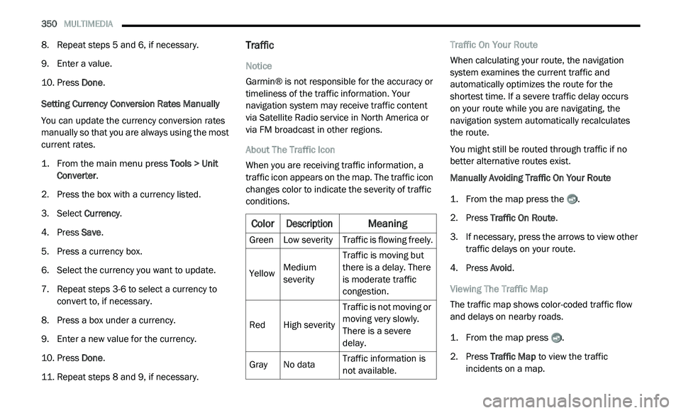
About The Traffic Icon
When you are receiving traffic information, a
t r
affic icon appears on the map. The traffic icon
changes color to indicate the severity of traffic
conditions. Traffic On Your Route
When calculating your route, the navigation
s
y
stem examines the current traffic and
automatically optimizes the route for the
shortest time. If a severe traffic delay occurs
on your route while you are navigating, the
n a
vigation system automatically recalculates
the route.
You might still be routed through traffic if no
b e
tter alternative routes exist.
Manually Avoiding Traffic On Your Route
1. Fr om the map press the .
2
. P ress Traffic On Route .
3
. I f necessary, press the arrows to view other
t
raffic delays on your route.
4. P ress Avoid .
V
iewing The Traffic Map
The traffic map shows color-coded traffic flow
a n
d delays on nearby roads.
1. Fr om the map press .
2
. P ress Traffic Map
to view the traffic
incidents on a map.
Color
Description
Meaning
GreenLow severity Traffic is flowing freely.
Yellow Medium
s
e
verity Traffic is moving but
t
h
ere is a delay. There
is moderate traffic
congestion.
Red High severity Traffic is not moving or
m
o
ving very slowly.
There is a severe
delay.
Gray No data Traffic information is
n
o
t available.
Page 353 of 396
MULTIMEDIA 351
Searching For Traffic Delays
1. From the map page press .
2
. P ress Traffic Search to view a list of roads
w
ith traffic delays.
3. P ress an item in the list to view delays on
t
he road.
4. I f there is more than one delay, press the
a
rrows to view additional delays.
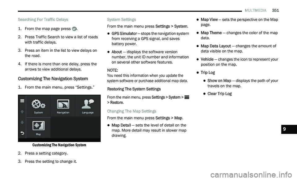
Customizing The Navigation System
1. From the main menu, press “Settings.”
Customizing The Navigation System
2. P ress a setting category.
3
. P ress the setting to change it. S
ystem Settings
From the main menu press Se
ttings > System.
GPS Simulator — stops the navigation system
from receiving a GPS signal, and saves
battery power.
About — displays the software version
number, the unit ID number and information
on several other software features.
NOTE:
You need this information when you update the
s y
stem software or purchase additional map data.
Restoring The System Settings
From the main menu, press Se
ttings > System >
> Restore .
Changing The Map Settings
From the main menu press Se
ttings > Map.
Map Detail — sets the level of detail on the
map. More detail may result in slower map
drawing.
Map View — sets the perspective on the Map
page.
Map Theme — changes the color of the map
data.
Map Data Layout — changes the amount of
data visible on the map.
Vehicle — changes the icon to represent your
position on the map.
Trip Log
Show on Map — displays the path of your
travels on the map.
Clear Trip Log
9