display INFINITI QX4 2001 Factory Service Manual
[x] Cancel search | Manufacturer: INFINITI, Model Year: 2001, Model line: QX4, Model: INFINITI QX4 2001Pages: 2395, PDF Size: 43.2 MB
Page 1568 of 2395

SEL460W
6. Touch ªOKº.
7. Carry out the next system setting or contact Communicator
Response Center and information them that data has been
updated or the IVCS unit has been replaced. For details, refer
to EL-381.
NOTE:
Whenever the phone number is updated or the IVCS unit is
replaced, the INFINITI Communicator system automatically
contacts the Communicator Response Center the first time the
vehicle is started.
SEL461W
PHONE SET UPNBEL0187S041. Touch ªCONFIGURATIONº.
2. Touch ªPHONE SET UPº.
SEL716W
3. Touch ªWRITEº or ªREWRITEº.
IIf no data is previously memorized, the display shows ªThis
unit has no required data programmedº.
SEL463W
IIf NAM (Number Assignment Module) data is previously
memorized, the display shows the current NAM data.
ITo erase the NAM, touch ªERASEº.
SEL464W
4. Input new NAM data.
ISYS ID (Carrier system ID number) Ð Available number: 0 to
32765
IGR ID (Group ID mark) Ð Available number: 0 to 15
IOVERLOAD CLASS (Access overload class) Ð Available
number: 0 to 15
ISECURITY CODE (User security code)
IUNLOCK CODE
IINIT PAGE CH (Initial paging channel)
GI
MA
EM
LC
EC
FE
AT
TF
PD
AX
SU
BR
ST
RS
BT
HA
SC
IDX
INFINITI COMMUNICATOR (IVCS)
System Setting (When IVCS Unit is Replaced) (Cont'd)
EL-383
Page 1571 of 2395

SEL683V
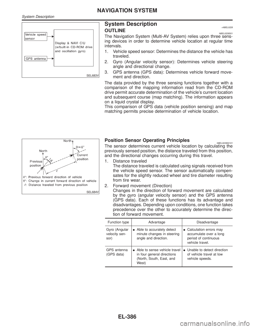
System Description=NBEL0228OUTLINENBEL0228S01The Navigation System (Multi-AV System) relies upon three sens-
ing devices in order to determine vehicle location at regular time
intervals.
1. Vehicle speed sensor: Determines the distance the vehicle has
traveled.
2. Gyro (Angular velocity sensor): Determines vehicle steering
angle and directional change.
3. GPS antenna (GPS data): Determines vehicle forward move-
ment and direction.
The data provided by the three sensing functions together with a
comparison of the mapping information read from the CD-ROM
drive permit accurate determination of the vehicle's current location
and subsequent course (map matching). The information appears
on a liquid crystal display.
This comparison of GPS data (vehicle position sensing) and map
matching permits precise determination of vehicle location.
SEL684V
Position Sensor Operating PrinciplesNBEL0228S0101The sensor determines current vehicle location by calculating the
previously sensed position, the distance traveled from this position,
and the directional changes occurring during this travel.
1. Distance traveled
The distance traveled is calculated using signals received from
the vehicle speed sensor. The sensor automatically compen-
sates for the slightly reduced wheel and tire diameter resulting
from tire wear.
2. Forward movement (Direction)
Changes in the direction of forward movement are calculated
by the gyro (angular velocity sensor) and the GPS antenna
(GPS data). Each of these functions has its advantage and
disadvantages. Depending upon conditions, one function takes
precedence over the other to accurately determine the direc-
tion of forward movement.
Function type Advantage Disadvantage
Gyro (Angular
velocity sen-
sor)IAble to accurately detect
minute changes in steering
angle and direction.ICalculation errors may
accumulate over a long
period of continuous
vehicle travel.
GPS antenna
(GPS data)IAble to sense vehicle travel
in four general directions
(North, South, East, and
West)IUnable to detect direction
of vehicle travel at low
vehicle speeds.
NAVIGATION SYSTEM
System Description
EL-386
Page 1573 of 2395

for example, when the vehicle is in a tunnel, in a parking lot
inside building, under an elevated superhighway or near strong
power lines, the location may not be detected. Turbulent/
electric weather conditions may also affect positioning perfor-
mance. If something is placed on the antenna, the radio wave
from GPS satellites may not be received.
SEL688V
COMPONENT DESCRIPTIONNBEL0228S02Display & NAVI Control UnitNBEL0228S0201IThe gyro (angular speed sensor) and the CD-ROM drive are
built-in units that control the navigation functions.
ISignals are received from the gyro, the vehicle speed sensor,
and the GPS antenna. Vehicle location is determined by com-
bining this data with the data contained in the CD-ROM map.
Locational information is shown on liquid crystal display panel.
IFinger-operated touch switches are positioned on the liquid
crystal display panel for easy operation.
IThe touch switches used to control the equipment are beneath
a glass sheet and two resistance membranes at the top of the
liquid crystal display panel. The switches are sensitive to resis-
tance value where touched with your finger to detect operat-
ing status.
SEL689V
CD-ROM DriverNBEL0228S0202Maps, traffic control regulations, and other pertinent information
can be easily red from the CD-ROM disc.
NOTE:
IWhen removing the CD-ROM, allow it to remain open until the
liquid crystal display locks.
IThe liquid crystal display must be closed when the vehicle is
running.
IDo not place cups, cans or other containers containing liquids
on top of the liquid crystal display.
Map CD-ROMNBEL0228S0203IThe map CD-ROM has maps, traffic control regulations, and
other pertinent information.
ITo improve CD-ROM map matching and route determination
functions, the CD-ROM uses an exclusive Nissan format.
Therefore, the use of a CD-ROM provided by other manufac-
turers cannot be used.
NAVIGATION SYSTEM
System Description (Cont'd)
EL-388
Page 1574 of 2395

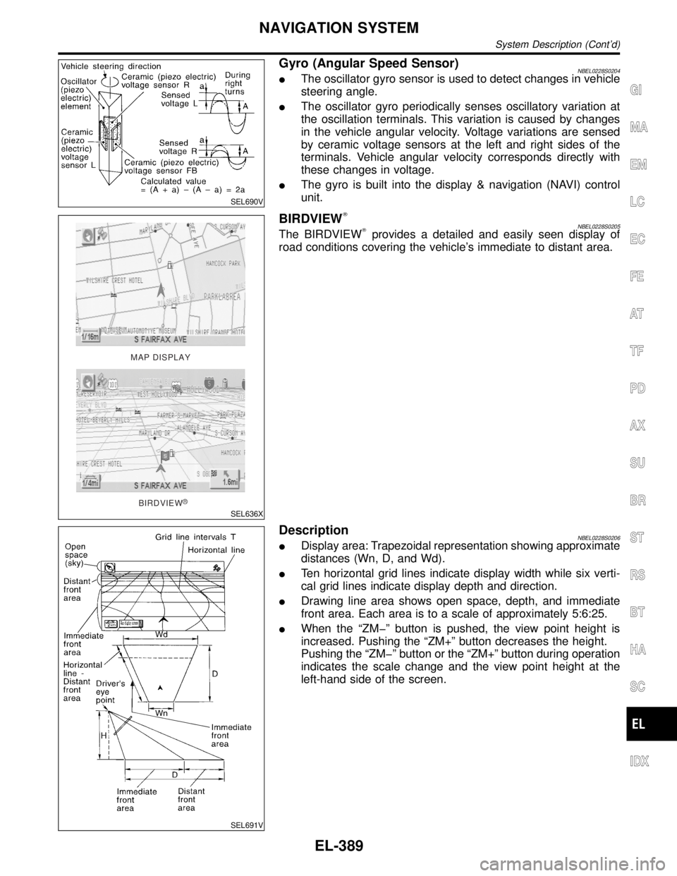
SEL690V
Gyro (Angular Speed Sensor)NBEL0228S0204IThe oscillator gyro sensor is used to detect changes in vehicle
steering angle.
IThe oscillator gyro periodically senses oscillatory variation at
the oscillation terminals. This variation is caused by changes
in the vehicle angular velocity. Voltage variations are sensed
by ceramic voltage sensors at the left and right sides of the
terminals. Vehicle angular velocity corresponds directly with
these changes in voltage.
IThe gyro is built into the display & navigation (NAVI) control
unit.
MAP DISPLAY
BIRDVIEW
R
SEL636X
BIRDVIEWTNBEL0228S0205The BIRDVIEWTprovides a detailed and easily seen display of
road conditions covering the vehicle's immediate to distant area.
SEL691V
DescriptionNBEL0228S0206IDisplay area: Trapezoidal representation showing approximate
distances (Wn, D, and Wd).
ITen horizontal grid lines indicate display width while six verti-
cal grid lines indicate display depth and direction.
IDrawing line area shows open space, depth, and immediate
front area. Each area is to a scale of approximately 5:6:25.
IWhen the ªZMþº button is pushed, the view point height is
increased. Pushing the ªZM+º button decreases the height.
Pushing the ªZMþº button or the ªZM+º button during operation
indicates the scale change and the view point height at the
left-hand side of the screen.
GI
MA
EM
LC
EC
FE
AT
TF
PD
AX
SU
BR
ST
RS
BT
HA
SC
IDX
NAVIGATION SYSTEM
System Description (Cont'd)
EL-389
Page 1575 of 2395

FUNCTION OF TOUCH SWITCH (SUMMARY)=NBEL0228S03Display with Pushed ªMAPº SwitchNBEL0228S0301
SEL580X
The function of each touch switch is as follows:
1) Azimuth indication
2) Position marker
The tip of the arrow shows the current position. The shaft of
the arrow indicates the direction in which the vehicle is travel-
ing.
3) GPS reception signal (indicates current reception conditions)
4) Distance display (shows the distance in a reduced scale)
5) Current location voice information
(this information is available when the route guide is being
activated and the designated route is being traveled.)
6) Switch display from map screen to BIRDVIEW
Tscreen
(change to map screen on display when the BIRDVIEWTis
being used.)
7) The following items can be set.
ISave Current Location
IEdit Address Book
IGuide Volume
ISystem Setting
8) The route guide operation can be canceled.
NAVIGATION SYSTEM
System Description (Cont'd)
EL-390
Page 1576 of 2395

Display with Pushed ªDESTº Switch=NBEL0228S0302
SEL581X
The function of each touch switch is as follows:
Icon Description
Address Book Favorite place can be saved to memory.
The destination can be selected from the memory.
Address/Street The destination can be searched from the address.
Point of Interest (POI) The destination of favorite facility can be searched.
Previous Dest. The previous ten destinations stored in memory are
displayed.
Intersection The destination from the intersection name can be
retrieved.
City The destination can be searched from city name.
Map The destination can be searched from the map.
GI
MA
EM
LC
EC
FE
AT
TF
PD
AX
SU
BR
ST
RS
BT
HA
SC
IDX
NAVIGATION SYSTEM
System Description (Cont'd)
EL-391
Page 1577 of 2395

Display with Toutch ScreenNBEL0228S0303
SEL582X
The function of each touch switch is as follows:
Icon Description
Quick Stop The selected facility is set as the destination or way-
point. (Route guidance has been turned OFF or the
destination has been reached.)
Where am I? Next, current and previous street names can be dis-
played.
Route Info.* The following items can be set.
IComplete Route
ITurn List
IRoute Simulation
(Displayed only when the destination area has been
set.)
Detour* Based on the selected distance, an alternative route is
searched. [Displayed only when the recommended
route (not its reverse) is followed.]
Edit Route* Change the destination or add the transit points of the
route set in the route guide. (Displayed only when the
automatic reroute function has been turned OFF and
the recommended route is not followed.)
Route Calc. Search for a recommended route between the vehi-
cle's current location and the destination area. (Dis-
played only when the destination area has been set.)
*: When destinations have been entered, route guidance has been turned OFF or
destination has been reached, ªRoute Info.º, ªDetourº, ªEdit Routeº and ªRoute
Calc.º are not displayed.
NAVIGATION SYSTEM
System Description (Cont'd)
EL-392
Page 1582 of 2395

Self-diagnosis ModeNBEL0231APPLICATION ITEMSNBEL0231S01
Mode DescriptionReference
page
Self DiagnosisSelf-diagnosis for display & NAVI control unit, CD-ROM
and GPS antenna connection.EL-398
Confirmation/
adjustmentDisplay Diagnosis Color and gray gradation of display can be checked in
this mode.EL-406
Diagnostic Signals from the Car Several input signals to display & NAVI control unit, can
be monitored in this mode.EL-404
NavigationCheck the map CD-
ROM versionThe version (parts number) of inserted CD-ROM can be
checked in this mode.EL-405
Error history Diagnosis results previously stored in the memory
(before turning ignition switch ON) are displayed in this
mode. Time and location when/where the errors
occurred are also displayed.EL-400
Longitude & Latitude Display the map. Use the joystick to adjust position. Lon-
gitude and latitude will be displayed.EL-407
Adjust the angle Turning angle of the vehicle on the display can be
adjusted in this mode.EL-408
Speed CalibrationUnder ordinary conditions, the navigation system dis-
tance measuring function will automatically compensate
for minute decreases in wheel and tire diameter caused
by tire wear or low pressure. Speed calibration immedi-
ately restores system accuracy in cases such as when
distance calibration is needed because of the use of tire
chains in inclement weather.EL-409
Initialize Location This mode is for initializing the current location. Use
when the vehicle is transported a long distance on a
trailer, etc.EL-433
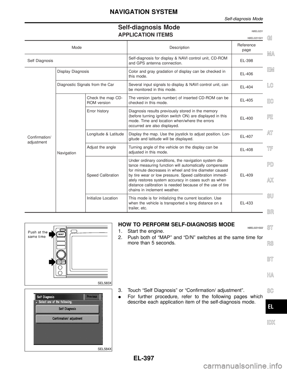
SEL583X
HOW TO PERFORM SELF-DIAGNOSIS MODENBEL0231S021. Start the engine.
2. Push both of ªMAPº and ªD/Nº switches at the same time for
more than 5 seconds.
SEL584X
3. Touch ªSelf Diagnosisº or ªConfirmation/ adjustmentº.
IFor further procedure, refer to the following pages which
describe each application item of the self-diagnosis mode.
GI
MA
EM
LC
EC
FE
AT
TF
PD
AX
SU
BR
ST
RS
BT
HA
SC
IDX
NAVIGATION SYSTEM
Self-diagnosis Mode
EL-397
Page 1583 of 2395

SEL584X
ªSelf DiagnosisºNBEL0231S02011. Start the engine.
2. Push both ªMAPº and ªD/Nº switches at the same time for more
than 5 seconds.
3. Touch ªSelf Diagnosisº.
SEL585X
4. Self-diagnosis will be performed.
SEL586X
5. Diagnosis results will be displayed. Diagnosis results are indi-
cated by display color. For details refer to ªSELF-DIAGNOSIS
RESULTSº.
SEL587X
To obtain detailed diagnosis results on the screen, touch ªNaviga-
tionº or ªGPS Antennaº.
NAVIGATION SYSTEM
Self-diagnosis Mode (Cont'd)
EL-398
Page 1584 of 2395

SELF-DIAGNOSIS RESULTS=NBEL0231S03
Diagnosed
itemDisplayed
colorDetailed result DescriptionDiagnoses/service procedure
Recheck system at each check or
replacement (When malfunction is
eliminated, further repair work is
not required.)
ªGPS
Antennaº
(GPS
antenna con-
nection)Green ÐGPS antenna is connected to dis-
play & NAVI control unit correctly.Ð
YellowConnection to the follow-
ing unit is abnormal. See
the Service Manual for
further diagnosis.GPS antenna connection error is
detected.1. Check GPS antenna feeder cable
connection at display & NAVI
control unit.
2. Visually check GPS antenna
feeder cable. If NG, replace GPS
antenna assembly.
3. Replace GPS antenna.
ªNavigationº
(Display &
NAVI control
unit)Green Ð No failure is detected. Ð
Red [*** is abnormal.]Display & NAVI control unit is mal-
functioning.Replace display & NAVI control unit.
GraySelf-diagnosis for CD-
ROM DRIVER of DISP &
NAVI was not conducted
due to no insertion of
CD-ROM.Any CD-ROM is not inserted or dis-
play & NAVI control unit is malfunc-
tioning.1. Confirm that map CD-ROM is not
inserted into display & NAVI con-
trol unit.
2. Replace display & NAVI control
unit.
YellowCD-ROM or CD-ROM
DRIVER of DISP & NAVI
is abnormal. See the
Service Manual for fur-
ther diagnosis.Display & NAVI control unit judges
that inserted CD-ROM is malfunc-
tioning.
Map CD-ROM or CD-ROM driver of
the unit is malfunctioning.1. Confirm the disk is installed cor-
rectly (not up side down.)
2. Perform ªCD-ROM VERSION
CHECKº in EL-405 to confirm
whether correct CD-ROM is
inserted or not.
3. Check the disk surface. Are there
any scratches, abrasions or pits
on the surface?
4. Replace the CD-ROM.
5. Replace display & NAVI control
unit. CD-ROM is abnormal.
Please check the disc.Inserted map CD-ROM can not be
read.
Map CD-ROM or CD-ROM driver of
the unit is malfunctioning.
Connection to the follow-
ing unit is abnormal. See
the Service Manual for
further diagnosis.GPS antenna connection error is
detected.1. Check GPS antenna feeder cable
connection at display & NAVI
control unit.
2. Visually check GPS antenna
feeder cable. If NG, replace GPS
antenna assembly.
3. Replace GPS antenna.
GI
MA
EM
LC
EC
FE
AT
TF
PD
AX
SU
BR
ST
RS
BT
HA
SC
IDX
NAVIGATION SYSTEM
Self-diagnosis Mode (Cont'd)
EL-399