service MAZDA MODEL CX-3 2016 Navigation Manual (in English)
[x] Cancel search | Manufacturer: MAZDA, Model Year: 2016, Model line: MODEL CX-3, Model: MAZDA MODEL CX-3 2016Pages: 90, PDF Size: 5.47 MB
Page 2 of 90

2
1 Warnings and Safety information ................................. 4
2 Getting
started ............................................................... 6
2.1 Before using the navigation system .................................................. 6
2.2 Navigation
menu ............................................................................... 8
2.3
Buttons
and other controls on the screen ...................................... 10
2.3.1 Using keyboards .................................................................................. 10
2.3.2
Press and Hold ...................................................................................... 11
2.4 Map screen ...................................................................................... 12
2.4.1 Navigating on the map ........................................................................ 12
2.4.2
Position markers ................................................................................. 13
2.4.2.1
Selected map location (Cursor) and selected map object ...... 13
2.4.3
Objects on the map ............................................................................. 13
2.4.3.1
Streets and roads .................................................................... 13
2.4.3.2
Turn preview and Next street ................................................. 14
2.4.3.3
Lane information and Signposts ............................................ 16
2.4.3.4
Junction view .......................................................................... 17
2.4.3.5
Highway/Freeway exit services ............................................. 17
2.4.3.6
Elements of the active route ................................................... 19
2.4.4
Manipulating the map .......................................................................... 20
2.4.5
Checking the details of the current position (Where
Am I?)
.............. 23
3 On-road navigation ...................................................... 24
3.1 Selecting the destination of a route ............................................... 24
3.1.1 Entering an address or a part of the address ........................................ 25
3.1.1.1
Entering an address ................................................................ 25
3.1.1.2
Entering the midpoint of a street as the destination ............... 30
3.1.1.3
Selecting an intersection as the destination ............................ 33
3.1.1.4
Selecting a city center as the destination ............................... 36
3.1.2
Selecting the destination from the POI (point of interest) ................... 38
3.1.2.1
Quick search for a POI (point of interest) ............................... 38
3.1.2.2
Searching for Help nearby ..................................................... 41
3.1.2.3
Searching for a POI (point of interest) by category ................ 44
3.1.2.4
Searching for a POI (point of interest) by name ..................... 48
3.1.3
Searching for a Place using Local Search (Only some coun
tries and
regions)
................................................................................................ 52
3.1.4
Selecting a map location as the destination ........................................ 54
3.1.5
Selecting the destination from your Favorites .................................... 56
Table of contents
NAV-12AVUAE.indb 22015/02/20 15:09:05
Page 17 of 90

17
1
2
3
4
5
6
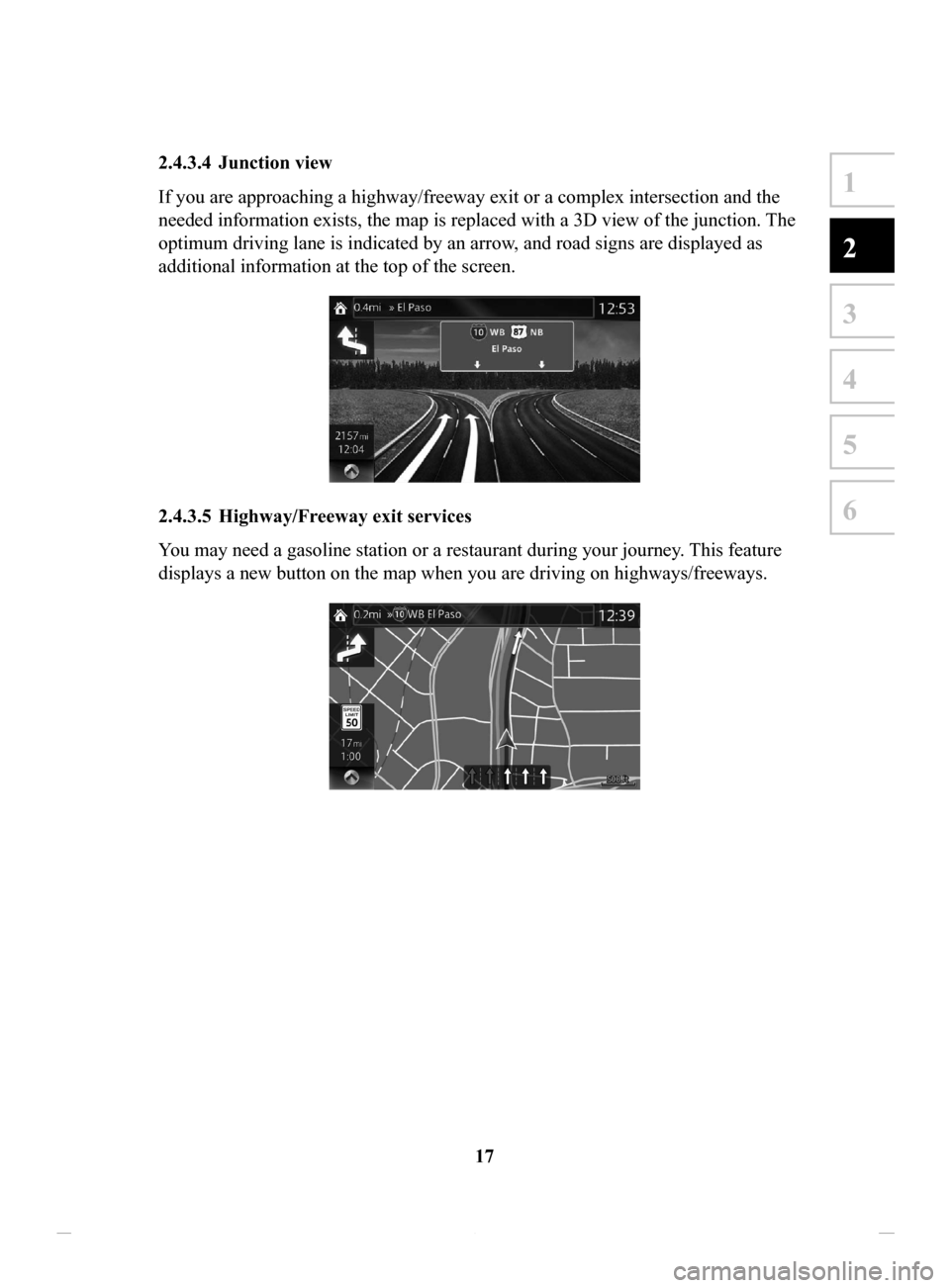
2.4.3.4 Junction view
If you are approaching a highway/freeway exit or a complex intersection and the
needed information exists, the map is replaced with a 3D view of the junction. The
optimum driving lane is indicated by an arrow, and road signs are displayed as
additional information at the top of the screen.
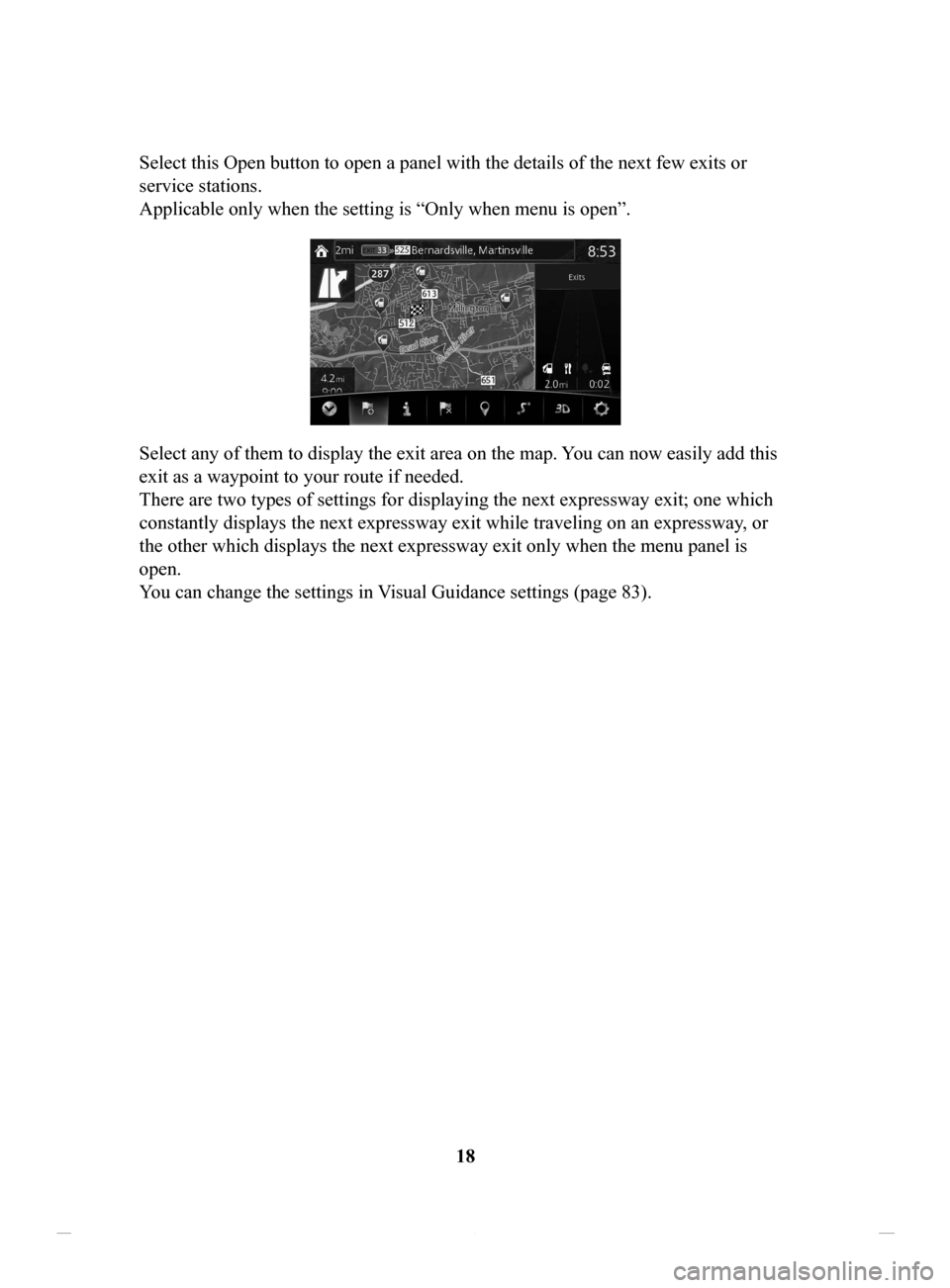
2.4.3.5 Highway/Freeway exit services
You may need a gasoline station or a restaurant during your journey. This feature
displays a new button on the map when you are driving on highways/freeways.
NAV-12AVUAE.indb 172015/02/20 15:09:07
Page 18 of 90

18
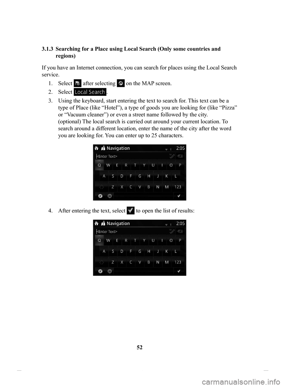
Select this Open button to open a panel with the details of the next few exits or
service stations.
Applicable only when the setting is “Only when menu is open”.
Select any of them to display the exit area on the map. You can now easily add this
exit as a waypoint to your route if needed.
There are two types of settings for displaying the next expressway exit; one which
constantly displays the next expressway exit while traveling on an expressway
, or
the other which displays the next expressway exit only when the menu panel is
open.
You can change the settings in Visual Guidance settings (page 83).
NAV-12AVUAE.indb 182015/02/20 15:09:07
Page 52 of 90

52
3.1.3 Searching
for a Place using Local Search (Only some countries and
regions)
If you have an Internet connection, you can search for places using the Local Search
service. 1.
Select after selecting on the MAP screen.
2.
Select .
3.
Using the keyboard, start entering the text to search for. This text can be a
type of Place (like “Hotel”), a type of goods you are looking for (like “Pizza”
or “V
acuum cleaner”) or even a street name followed by the city.
(optional) The local search is carried out around your current location. To
search around a different location, enter the name of the city after the word
you are looking for. You can enter up to 25 characters.
4. After entering the text, select to open the list of results:
NAV-12AVUAE.indb 522015/02/20 15:09:12
Page 77 of 90

77
1
2
3
4
5
6
4.2 Settings menu
You can configure the program settings, and modify the behaviour of the navigation
system. Select
after selecting on the MAP screen.
ButtonDescription
You can fine-tune the appearance of the Map screen. Adjust
the map view to your needs, show or hide 3D buildings, and
manage POI (point of interest) display settings (which POI
to show on map).
A guidance-related setting is available during route
guidance.
A setting related to warnings is available.
Refer to Changing the road types used in route planning
(page 68).
A setting for traffic information is available.
A setting for on-line service is available.
Some functions are not available depending on some countries and regions.
NAV-12AVUAE.indb 772015/02/20 15:09:15
Page 86 of 90

86
6 End-User Terms
The data (“Data”) is provided for your personal, internal use only and not for resale.
It is protected by copyright, and is subject to the following terms and conditions
which are agreed to by you, on the one hand, and [CLIENT] (“[CLIENT]”) and its
licensors (including their licensors and suppliers) on the other hand.
© 200X NAVTEQ [Insert any applicable copyright notices as required for the
country-specific Data being used]. All rights reserved.
The Data for areas of Canada includes information taken with permission from
Canadian authorities, including: © Her Majesty the Queen in Right of Canada, ©
Queen's Printer for Ontario, © Canada Post Corporation, GeoBase
®, © Department
of Natural Resources Canada.
NAVTEQ holds a non-exclusive license from the United States Postal Service
® to
publish and sell ZIP+4® information.
©United States Postal Service
® 200X. Prices are not established, controlled or
approved by the United States Postal Service®. The following trademarks and
registrations are owned by the USPS: United States Postal Service, USPS, and
ZIP+4.
Terms
and Conditions
Personal Use Only. You agree to use this Data together with [insert name of
CLIENT’
s authorized Application] for the solely personal, non-commercial
purposes for which you were licensed, and not for service bureau, time-sharing
or other similar purposes. Accordingly, but subject to the restrictions set forth
in the following paragraphs, you may copy this Data only as necessary for your
personal use to (i) view it, and (ii) save it, provided that you do not remove any
copyright notices that appear and do not modify the Data in any way . You agree
not to otherwise reproduce, copy, modify, decompile, disassemble, create any
derivative works of, or reverse engineer any portion of this Data, and may not
transfer or distribute it in any form, for any purpose, except to the extent permitted
by mandatory laws.
NAV-12AVUAE.indb 862015/02/20 15:09:16
Page 87 of 90

87
1
2
3
4
5
6
6 End-User Terms
The data (“Data”) is provided for your personal, internal use only and not for resale.
It is protected by copyright, and is subject to the following terms and conditions
which are agreed to by you, on the one hand, and [CLIENT] (“[CLIENT]”) and its
licensors (including their licensors and suppliers) on the other hand.
© 200X NAVTEQ [Insert any applicable copyright notices as required for the
country-specific Data being used]. All rights reserved.
The Data for areas of Canada includes information taken with permission from
Canadian authorities, including: © Her Majesty the Queen in Right of Canada, ©
Queen's Printer for Ontario, © Canada Post Corporation, GeoBase
®, © Department
of Natural Resources Canada.
NAVTEQ holds a non-exclusive license from the United States Postal Service
® to
publish and sell ZIP+4® information.
©United States Postal Service
® 200X. Prices are not established, controlled or
approved by the United States Postal Service®. The following trademarks and
registrations are owned by the USPS: United States Postal Service, USPS, and
ZIP+4.
Terms and Conditions
Personal Use Only. You agree to use this Data together with [insert name of
CLIENT’s authorized Application] for the solely personal, non-commercial
purposes for which you were licensed, and not for service bureau, time-sharing
or other similar purposes. Accordingly, but subject to the restrictions set forth
in the following paragraphs, you may copy this Data only as necessary for your
personal use to (i) view it, and (ii) save it, provided that you do not remove any
copyright notices that appear and do not modify the Data in any way . You agree
not to otherwise reproduce, copy, modify, decompile, disassemble, create any
derivative works of, or reverse engineer any portion of this Data, and may not
transfer or distribute it in any form, for any purpose, except to the extent permitted
by mandatory laws.
Restrictions. Except where you have been specifically licensed to do so by
[CLIENT], and without limiting the preceding paragraph, you may not (a) use this
Data with any products, systems, or applications installed or otherwise connected
to or in communication with vehicles, capable of vehicle navigation, positioning,
dispatch, real time route guidance, fleet management or similar applications; or (b)
with or in communication with any positioning devices or any mobile or wireless-
connected electronic or computer devices, including without limitation cellular
phones, palmtop and handheld computers, pagers, and personal digital assistants or
PDAs.
Warning. The Data may contain inaccurate or incomplete information due to the
passage of time, changing circumstances, sources used and the nature of collecting
comprehensive geographic data, any of which may lead to incorrect results.
No Warranty. This Data is provided to you “as is,” and you agree to use it at your
own risk. [CLIENT] and its licensors (and their licensors and suppliers) make no
guarantees, representations or warranties of any kind, express or implied, arising
by law or otherwise, including but not limited to, content, quality , accuracy,
completeness, effectiveness, reliability, fitness for a particular purpose, usefulness,
use or results to be obtained from this Data, or that the Data or server will be
uninterrupted or error-free.
Disclaimer of Warranty: [CLIENT] AND ITS LICENSORS (INCLUDING THEIR
LICENSORS AND SUPPLIERS) DISCLAIM ANY WARRANTIES, EXPRESS
OR IMPLIED, OF QUALITY, PERFORMANCE, MERCHANTABILITY,
FITNESS FOR A PARTICULAR PURPOSE OR NON-INFRINGEMENT. Some
States, Territories and Countries do not allow certain warranty exclusions, so to that
extent the above exclusion may not apply to you.
NAV-12AVUAE.indb 872015/02/20 15:09:16