low NISSAN GT-R 2013 R35 Multi Function Display Owners Manual
[x] Cancel search | Manufacturer: NISSAN, Model Year: 2013, Model line: GT-R, Model: NISSAN GT-R 2013 R35Pages: 315, PDF Size: 6.96 MB
Page 6 of 315
0-2Introduction
This manual uses special words, symbols and
icons, organized by function.
Please refer to the following items and familiarize
yourself with them.
FOR SAFE OPERATION
WARNING
This is used to indicate a hazard that
could cause death or serious personal
injury. To avoid or reduce the risk,
follow the information and instructions
exactly.
CAUTION
This is used to indicate a hazard that
could cause minor or moderate perso-
nal injury. To avoid or reduce the risk,
follow the information and instructions
carefully.
NOTICE
This is used to indicate a hazard that
could cause damage to your vehicle. To
avoid or reduce the risk, follow the
information and instructions.
REFERENCE SYMBOLS
INFO:
This indicates information that is necessary for
efficient use of your vehicle or accessories.
Reference page:
This indicates the title and page that you should
refer to.
<>:
This indicates a button on the control panel.
[]:
This indicates a key/item displayed on the
screen.
Voice Command:
This indicates an operation by voice command.
This system is primarily designed to help you
reach your destination, and it also performs
other functions as outlined in this manual.
However, you, the driver, must use the system
safely and properly. Information concerning road
conditions, traffic signs and the availability of
services may not always be up-to-date. The
system is not a substitute for safe, proper and
legal driving.
Before using the navigation system, please read
the following safety information. Always use the
system as outlined in this manual.
WARNING
. When the driver wants to operate
the navigation system or use the
center dial, first park the vehicle in a
safe location and set the parking
brake. Operating the system while
driving can distract the driver and
may result in a serious accident.
. Do not rely on route guidance alone.
Always be sure that all driving
maneuvers are legal and safe in
order to avoid accidents.
. Do not disassemble or modify this
system. If you do, it may result in
accidents, fire or electrical shock.
HOW TO USE THIS MANUAL SAFETY INFORMATION
Page 7 of 315
.If you notice any foreign objects in
the system hardware, spill liquid on
the system or notice smoke or a
smell coming from it, stop using the
system immediately and contact a
GT-R certified NISSAN dealer. Ignor-
ing such conditions may lead to
accidents, fire or electrical shock.
CAUTION
.Do not use this system if you notice
any malfunctions such as a frozen
screen or the lack of sound. Con-
tinued use of the system may result
in accidents, fire or electrical shock.
. Some states/provinces may have
laws limiting the use of video
screens while driving. Use this sys-
tem only where it is legal to do so.
. Extreme temperature conditions
[below −48F( −208 C) and above
1588F (708C)] could affect the per-
formance of the system.
NOTICE
Do not keep the navigation system
running with the engine stopped. Doing
so may discharge the vehicle battery.
When you use the navigation system,
always keep the engine running.
Introduction0-3
Page 14 of 315
1-4About Multi function display system
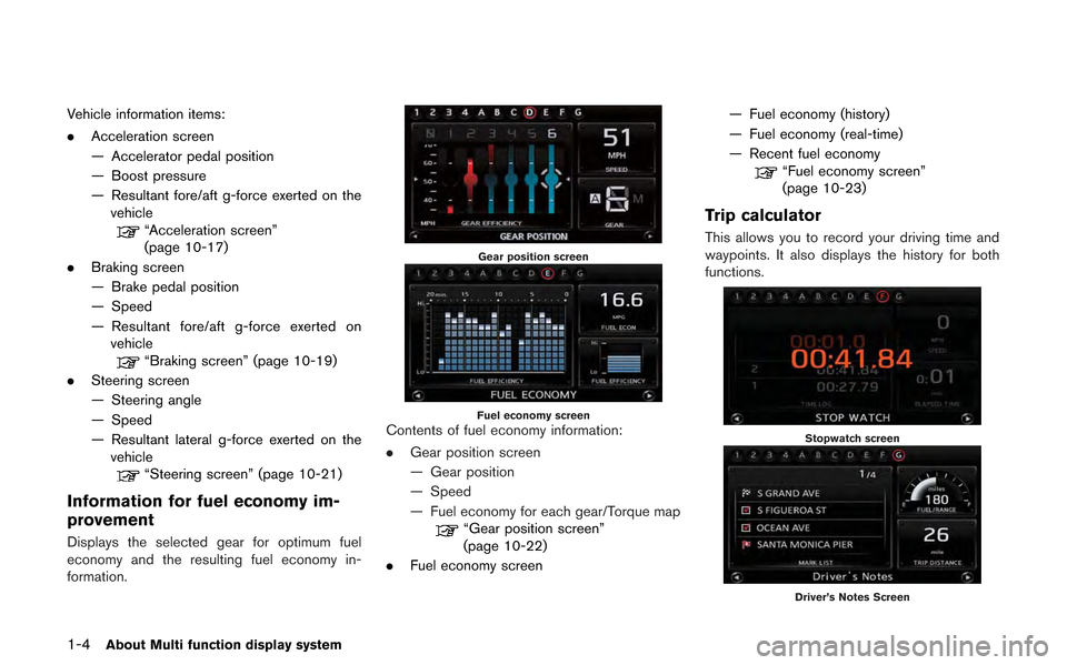
Vehicle information items:
.Acceleration screen
— Accelerator pedal position
— Boost pressure
— Resultant fore/aft g-force exerted on the
vehicle
“Acceleration screen”
(page 10-17)
. Braking screen
— Brake pedal position
— Speed
— Resultant fore/aft g-force exerted on
vehicle
“Braking screen” (page 10-19)
. Steering screen
— Steering angle
— Speed
— Resultant lateral g-force exerted on the
vehicle
“Steering screen” (page 10-21)
Information for fuel economy im-
provement
Displays the selected gear for optimum fuel
economy and the resulting fuel economy in-
formation.
Gear position screen
Fuel economy screenContents of fuel economy information:
. Gear position screen
— Gear position
— Speed
— Fuel economy for each gear/Torque map
“Gear position screen”
(page 10-22)
. Fuel economy screen — Fuel economy (history)
— Fuel economy (real-time)
— Recent fuel economy
“Fuel economy screen”
(page 10-23)
Trip calculator
This allows you to record your driving time and
waypoints. It also displays the history for both
functions.
Stopwatch screen
Driver’s Notes Screen
Page 17 of 315
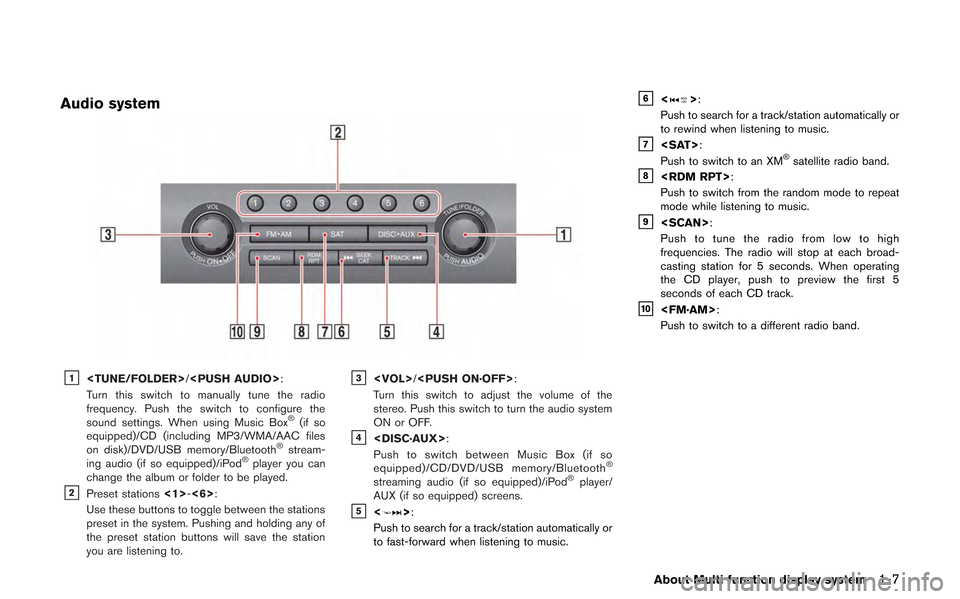
Audio system
&1
Turn this switch to manually tune the radio
frequency. Push the switch to configure the
sound settings. When using Music Box
®(if so
equipped)/CD (including MP3/WMA/AAC files
on disk)/DVD/USB memory/Bluetooth
®stream-
ing audio (if so equipped)/iPod®player you can
change the album or folder to be played.
&2Preset stations <1>-<6>:
Use these buttons to toggle between the stations
preset in the system. Pushing and holding any of
the preset station buttons will save the station
you are listening to.
&3
Turn this switch to adjust the volume of the
stereo. Push this switch to turn the audio system
ON or OFF.
&4
Push to switch between Music Box (if so
equipped)/CD/DVD/USB memory/Bluetooth
®
streaming audio (if so equipped)/iPod®player/
AUX (if so equipped) screens.
&5<>:
Push to search for a track/station automatically or
to fast-forward when listening to music.
&6<>:
Push to search for a track/station automatically or
to rewind when listening to music.
&7
Push to switch to an XM®satellite radio band.&8
Push to switch from the random mode to repeat
mode while listening to music.
&9
Push to tune the radio from low to high
frequencies. The radio will stop at each broad-
casting station for 5 seconds. When operating
the CD player, push to preview the first 5
seconds of each CD track.
&10
Push to switch to a different radio band.
About Multi function display system1-7
Page 20 of 315
1-10About Multi function display system
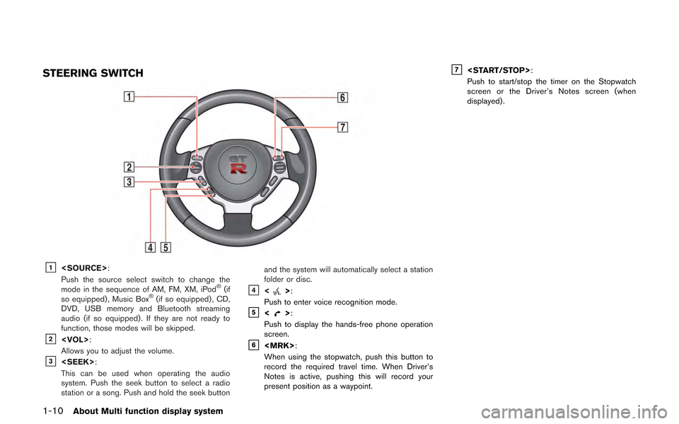
STEERING SWITCH
&1
Push the source select switch to change the
mode in the sequence of AM, FM, XM, iPod
®(if
so equipped) , Music Box®(if so equipped) , CD,
DVD, USB memory and Bluetooth streaming
audio (if so equipped) . If they are not ready to
function, those modes will be skipped.
&2
Allows you to adjust the volume.
&3
This can be used when operating the audio
system. Push the seek button to select a radio
station or a song. Push and hold the seek button and the system will automatically select a station
folder or disc.
&4<>:
Push to enter voice recognition mode.
&5<>:
Push to display the hands-free phone operation
screen.
&6
When using the stopwatch, push this button to
record the required travel time. When Driver’s
Notes is active, pushing this will record your
present position as a waypoint.
&7
Push to start/stop the timer on the Stopwatch
screen or the Driver’s Notes screen (when
displayed) .
Page 27 of 315
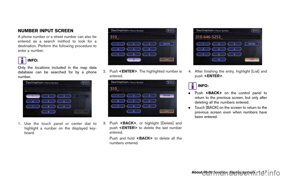
NUMBER INPUT SCREEN
A phone number or a street number can also be
entered as a search method to look for a
destination. Perform the following procedure to
enter a number.
INFO:
Only the locations included in the map data
database can be searched for by a phone
number.
1. Use the touch panel or center dial to highlight a number on the displayed key-
board.
2. Push
entered.
3. Push
push
entered.
Push and hold
numbers entered.
4. After finishing the entry, highlight [List] and push
INFO:
. Push
return to the previous screen, but only after
deleting all the numbers entered.
. Touch [BACK] on the screen to return to the
previous screen even when numbers have
been entered.
About Multi function display system1-17
Page 31 of 315
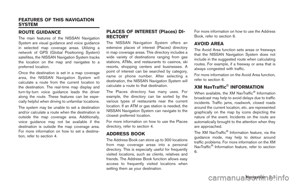
ROUTE GUIDANCE
The main features of the NISSAN Navigation
System are visual guidance and voice guidance
in selected map coverage areas. Utilizing a
network of GPS (Global Positioning System)
satellites, the NISSAN Navigation System tracks
the location on the map and navigates to a
preferred location.
Once the destination is set in a map coverage
area, the NISSAN Navigation System will
calculate a route from the current location to
the destination. The real-time map display and
turn-by-turn voice guidance leads the driver
along the route. These features can be espe-
cially helpful when driving to unfamiliar locations.
The system may be unable to set a destination
and/or calculate a route when the destination is
outside the map coverage area. Additionally,
voice guidance may not be available if the
destination is outside the map coverage area.
For more information on how to set a destina-
tion, refer to section 4.
PLACES OF INTEREST (Places) DI-
RECTORY
The NISSAN Navigation System offers an
extensive places of interest (Places) directory
in map coverage areas. This directory includes a
wide variety of destinations ranging from gas
stations, ATMs, and restaurants to casinos, ski
resorts, shopping centers and businesses. A
point of interest can be searched by category,
name or phone number. After selecting a
destination, the NISSAN Navigation System will
calculate a route to that destination.
The Places directory has many uses. For
example, the directory can be sorted by the
various types of restaurants near the current
location. If an ATM or gas station is needed, the
NISSAN Navigation System can navigate to the
closest preferred location.
For more information on how to use the Places
directory, refer to section 4.
ADDRESS BOOK
The Address Book can store up to 300 locations
from map coverage areas into a personal
directory. This is especially useful for frequently
visited locations, such as clients, relatives and
friends. The Address Book function allows easy
access to frequently visited locations when
setting them as your destination.For more information on how to use the Address
Book, refer to section 6.
AVOID AREA
The Avoid Area function sets areas or freeways
that the NISSAN Navigation System does not
include in the suggested route when calculating
routes. For example, if a freeway or area that is
always congested with traffic.
For more information on the Avoid Area function,
refer to section 6.
XM NavTraffic®INFORMATION
When available, the XM NavTraffic®Information
broadcast may help to avoid delays due to traffic
incidents. Traffic jams, roadwork, closed roads
around the current location, etc. are represented
graphically on the map by icons depicting the
nature of the event. Incidents on the route are
automatically brought to the attention when they
are approached.
The XM NavTraffic
®Information feature, via the
guidance mode, may help to detour around
traffic problems. For more information on the XM
NavTraffic
®Information feature, refer to section
6.
Navigation2-3
FEATURES OF THIS NAVIGATION
SYSTEM
Page 33 of 315
MAP TYPES
Two types of map views are available: 2D map
and BirdviewTM(3D) map.
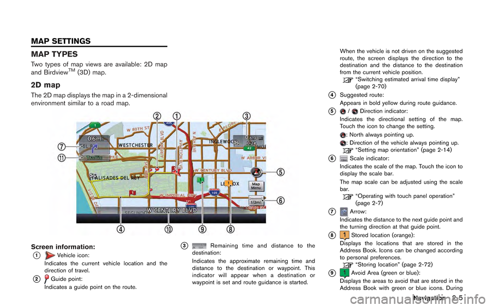
2D map
The 2D map displays the map in a 2-dimensional
environment similar to a road map.
Screen information:
*1Vehicle icon:
Indicates the current vehicle location and the
direction of travel.
*2Guide point:
Indicates a guide point on the route.
*3Remaining time and distance to the
destination:
Indicates the approximate remaining time and
distance to the destination or waypoint. This
indicator will appear when a destination or
waypoint is set and route guidance is started. When the vehicle is not driven on the suggested
route, the screen displays the direction to the
destination and the distance to the destination
from the current vehicle position.
“Switching estimated arrival time display”
(page 2-70)
*4Suggested route:
Appears in bold yellow during route guidance.
*5/Direction indicator:
Indicates the directional setting of the map.
Touch the icon to change the setting.
: North always pointing up.: Direction of the vehicle always pointing up.“Setting map orientation” (page 2-14)
*6Scale indicator:
Indicates the scale of the map. Touch the icon to
display the scale bar.
The map scale can be adjusted using the scale
bar.
“Operating with touch panel operation”
(page 2-7)
*7Arrow:
Indicates the distance to the next guide point and
the turning direction at that guide point.
*8Stored location (orange):
Displays the locations that are stored in the
Address Book. Icons can be changed according
to personal preferences.
“Storing location” (page 2-72)
*9Avoid Area (green or blue):
Displays the areas to avoid that are stored in the
Address Book with green or blue icons. During
Navigation2-5
MAP SETTINGS
Page 34 of 315
2-6Navigation
the route search, the route guidance is performed
by searching for a route that avoids those areas.
“Storing avoid area” (page 2-77)
*10Street name:
Displays the name of the street the vehicle is
currently driving on.
*11Traffic indicator:
Displays the reception condition of the traffic
information transmitted from the provider.
Green: Reception condition is good.
Gray: Reception condition is not good.
No mark: Subscription to XM NavTraffic
®service
is not detected.
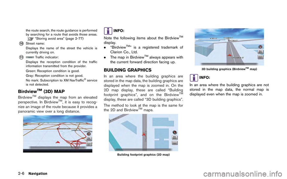
BirdviewTM(3D) MAP
BirdviewTMdisplays the map from an elevated
perspective. In BirdviewTM, it is easy to recog-
nize an image of the route because it provides a
panoramic view over a long distance.
INFO:
Note the following items about the Birdview
TM
display.
. “BirdviewTM” is a registered trademark of
Clarion Co., Ltd.
. The map in Birdview
TMalways appears with
the current forward direction facing up.
BUILDING GRAPHICS
In an area where the building graphics are
stored in the map data, the building graphics are
displayed when the map is zoomed in. On the
2D map display, these are called “Building
footprint graphics”, and on the Birdview
TM
display, these are called “3D building graphics”.
The method to look at the map is the same for
the 2D and Birdview
TMmaps.
Building footprint graphics (2D map)
3D building graphics (BirdviewTMmap)
INFO:
In an area where the building graphics are not
stored in the map data, the normal map is
displayed even when the map is zoomed in.
Page 36 of 315
2-8Navigation
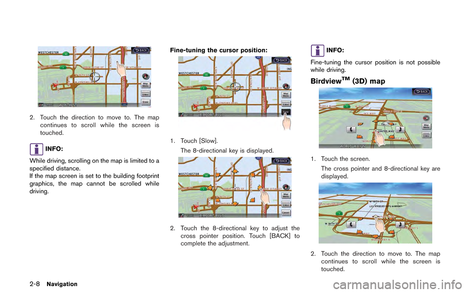
2. Touch the direction to move to. The mapcontinues to scroll while the screen is
touched.
INFO:
While driving, scrolling on the map is limited to a
specified distance.
If the map screen is set to the building footprint
graphics, the map cannot be scrolled while
driving. Fine-tuning the cursor position:
1. Touch [Slow].
The 8-directional key is displayed.
2. Touch the 8-directional key to adjust thecross pointer position. Touch [BACK] to
complete the adjustment.
INFO:
Fine-tuning the cursor position is not possible
while driving.
BirdviewTM(3D) map
1. Touch the screen. The cross pointer and 8-directional key are
displayed.
2. Touch the direction to move to. The mapcontinues to scroll while the screen is
touched.