TOYOTA VENZA 2014 Accessories, Audio & Navigation (in English)
Manufacturer: TOYOTA, Model Year: 2014, Model line: VENZA, Model: TOYOTA VENZA 2014Pages: 228, PDF Size: 3.73 MB
Page 21 of 228
21
1. NAVIGATION OPERATION
2
APPLICATION-“Map”
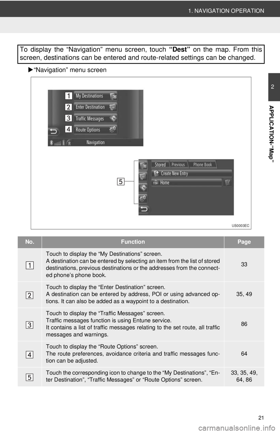
“Navigation” menu screen
To display the “Navigation” menu screen, touch “Dest” on the map. From this
screen, destinations can be entered and route-related settings can be changed.
No.FunctionPage
Touch to display the “My Destinations” screen.
A destination can be entered by selecting an item from the list of stored
destinations, previous destinations or the addresses from the connect-
ed phone’s phone book.
33
Touch to display the “Enter Destination” screen.
A destination can be entered by addr ess, POI or using advanced op-
tions. It can also be added as a waypoint to a destination.35, 49
Touch to display the “Traffic Messages” screen.
Traffic messages function is using Entune service.
It contains a list of traffic messages relating to the set route, all traffic
messages and warnings.
86
Touch to display the “Route Options” screen.
The route preferences, avoidance crit eria and traffic messages func-
tion can be adjusted.
64
Touch the corresponding icon to change to the “My Destinations”, “En-
ter Destination”, “Traffic Mess ages” or “Route Options” screen.33, 35, 49,
64, 86
Page 22 of 228
22
1. NAVIGATION OPERATION
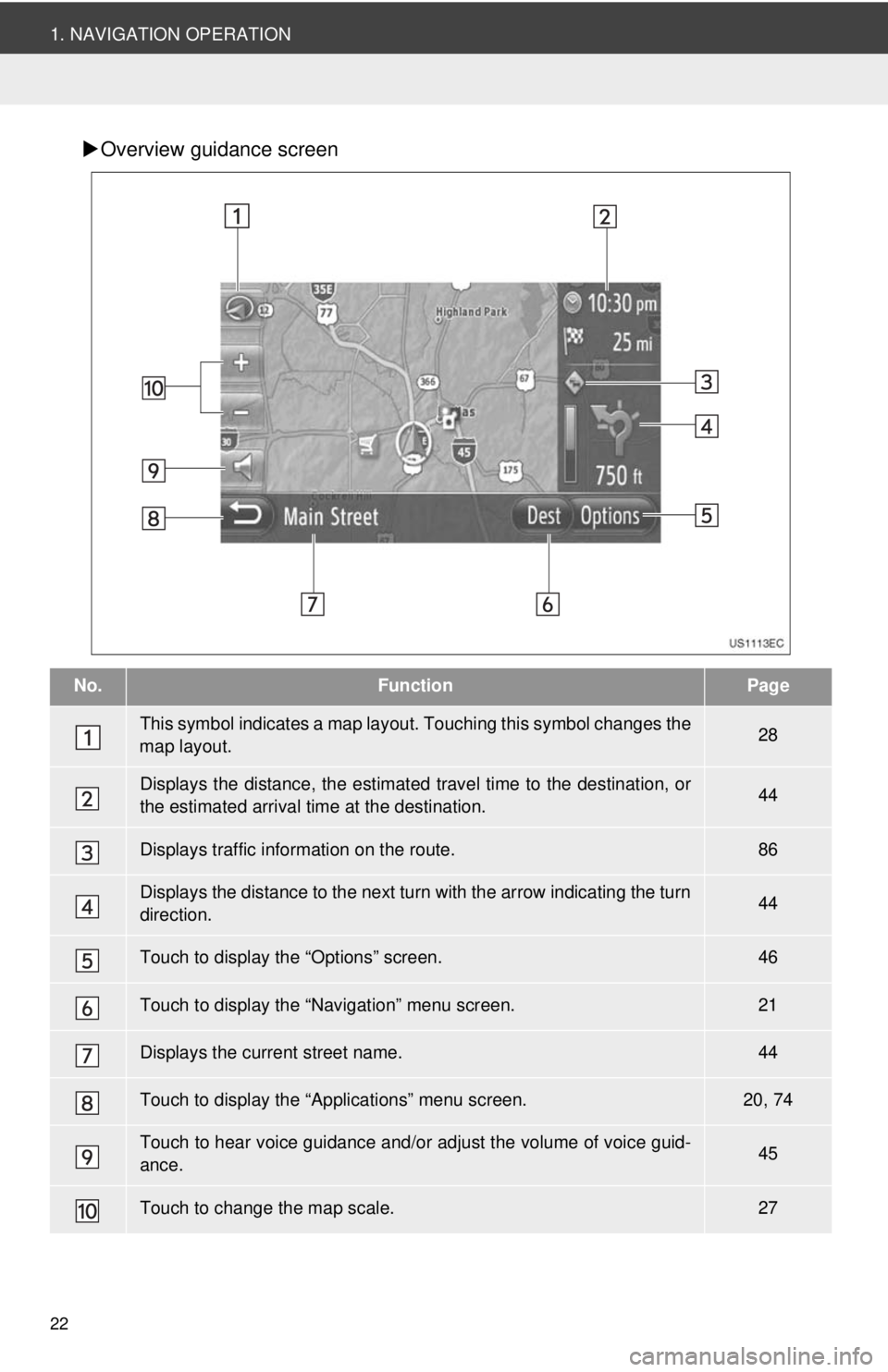
Overview guidance screen
No.FunctionPage
This symbol indicates a map layout. Touching th is symbol changes the
map layout.28
Displays the distance, the estimated travel time to the destination, or
the estimated arrival time at the destination.44
Displays traffic information on the route.86
Displays the distance to the next turn with the arrow indicating the turn
direction.44
Touch to display the “Options” screen.46
Touch to display the “Navigation” menu screen.21
Displays the current street name.44
Touch to display the “Applications” menu screen.20, 74
Touch to hear voice guidance and/or adjust the volume of voice guid-
ance.45
Touch to change the map scale.27
Page 23 of 228
23
2
APPLICATION-“Map”
1. NAVIGATION OPERATION
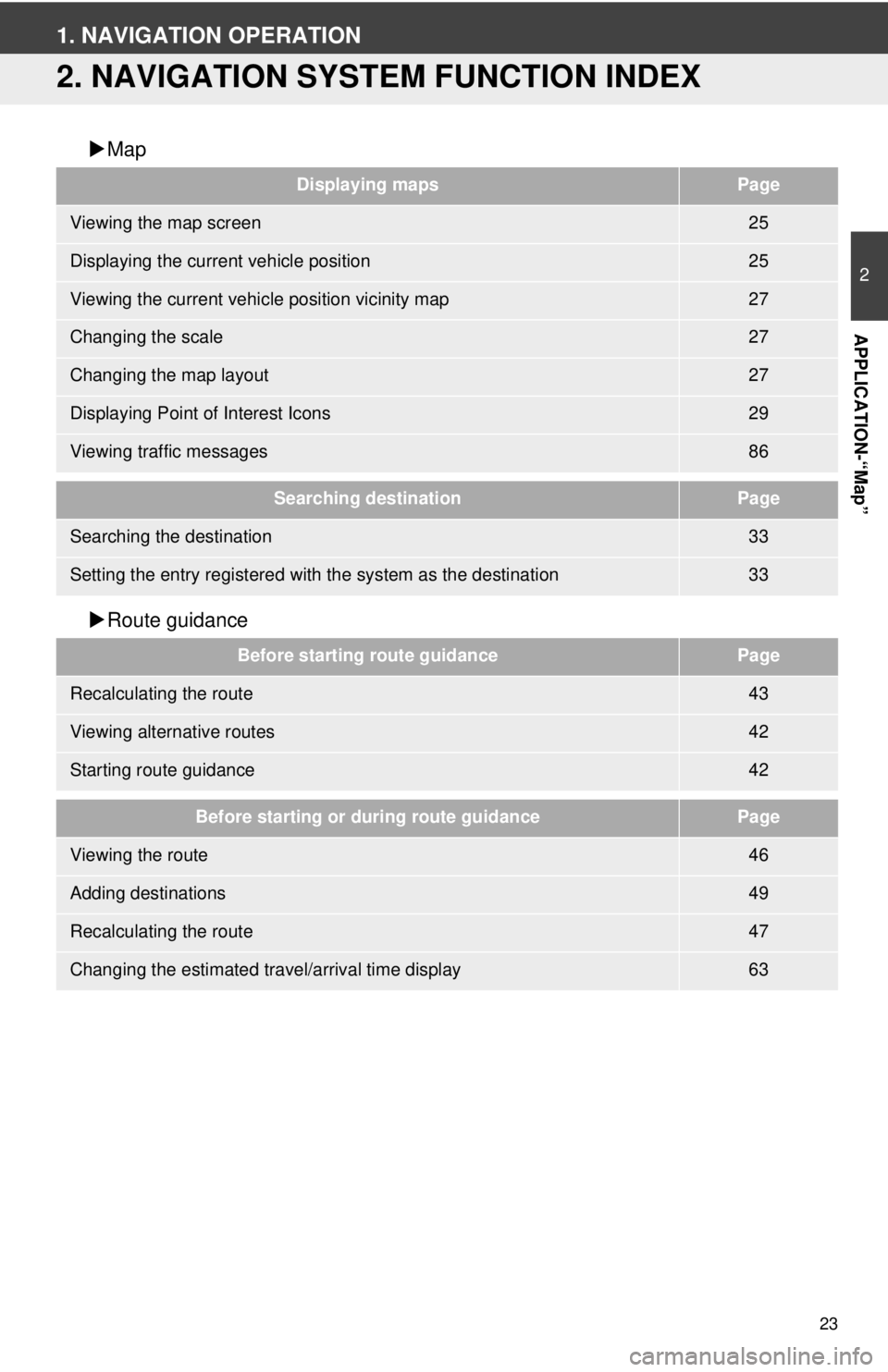
2. NAVIGATION SYSTEM FUNCTION INDEX
Map
Route guidance
Displaying mapsPage
Viewing the map screen25
Displaying the current vehicle position25
Viewing the current vehicle position vicinity map27
Changing the scale27
Changing the map layout27
Displaying Point of Interest Icons29
Viewing traffic messages86
Searching destinationPage
Searching the destination33
Setting the entry registered with the system as the destination33
Before starting route guidancePage
Recalculating the route43
Viewing alternative routes42
Starting route guidance42
Before starting or during route guidancePage
Viewing the route46
Adding destinations49
Recalculating the route47
Changing the estimated travel/arrival time display63
Page 24 of 228
24
1. NAVIGATION OPERATION
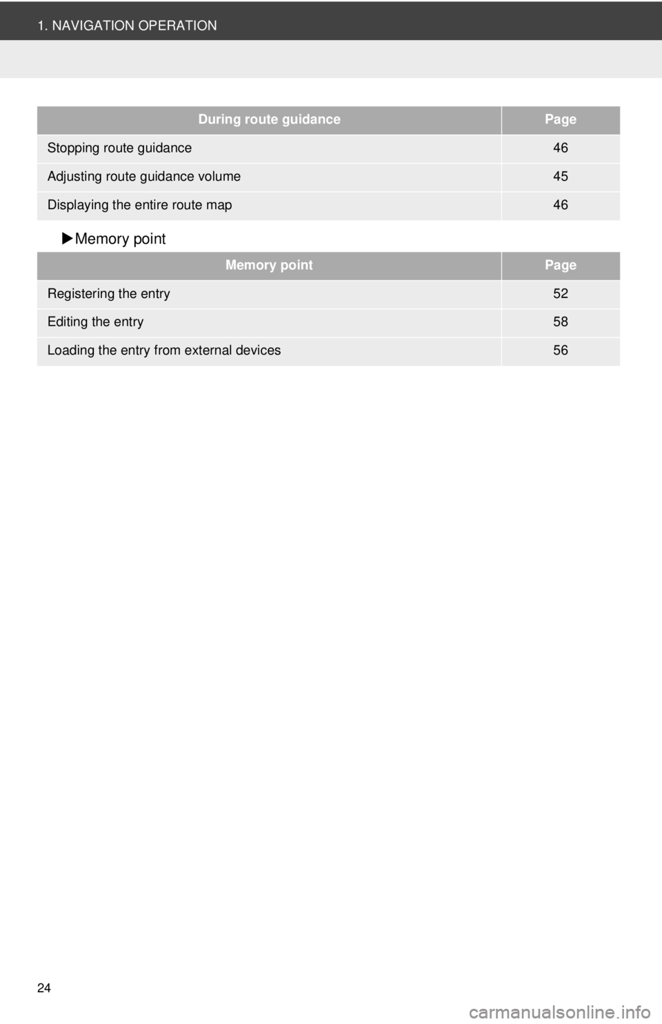
Memory point
During route guidancePage
Stopping route guidance46
Adjusting route guidance volume45
Displaying the entire route map46
Memory pointPage
Registering the entry52
Editing the entry58
Loading the entry from external devices56
Page 25 of 228
25
2
APPLICATION-“Map”
1. NAVIGATION OPERATION
3. MAP SCREEN OPERATION
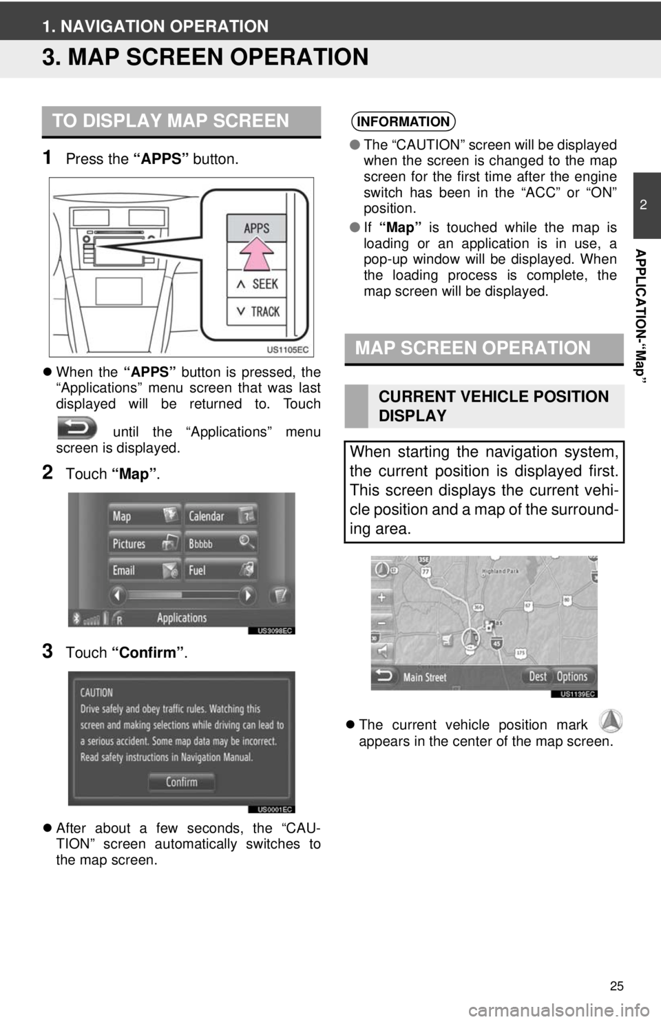
1Press the “APPS” button.
When the “APPS” button is pressed, the
“Applications” menu screen that was last
displayed will be returned to. Touch
until the “Applications” menu
screen is displayed.
2Touch “Map”.
3Touch “Confirm” .
After about a few seconds, the “CAU-
TION” screen automatically switches to
the map screen.
The current vehicle position mark
appears in the center of the map screen.
TO DISPLAY MAP SCREENINFORMATION
● The “CAUTION” screen will be displayed
when the screen is changed to the map
screen for the first time after the engine
switch has been in the “ACC” or “ON”
position.
● If “Map” is touched while the map is
loading or an application is in use, a
pop-up window will be displayed. When
the loading process is complete, the
map screen will be displayed.
MAP SCREEN OPERATION
CURRENT VEHICLE POSITION
DISPLAY
When starting the navigation system,
the current position is displayed first.
This screen displays the current vehi-
cle position and a map of the surround-
ing area.
Page 26 of 228
26
1. NAVIGATION OPERATION
■CURRENT LOCATION AND GPS IN-
FORMATION
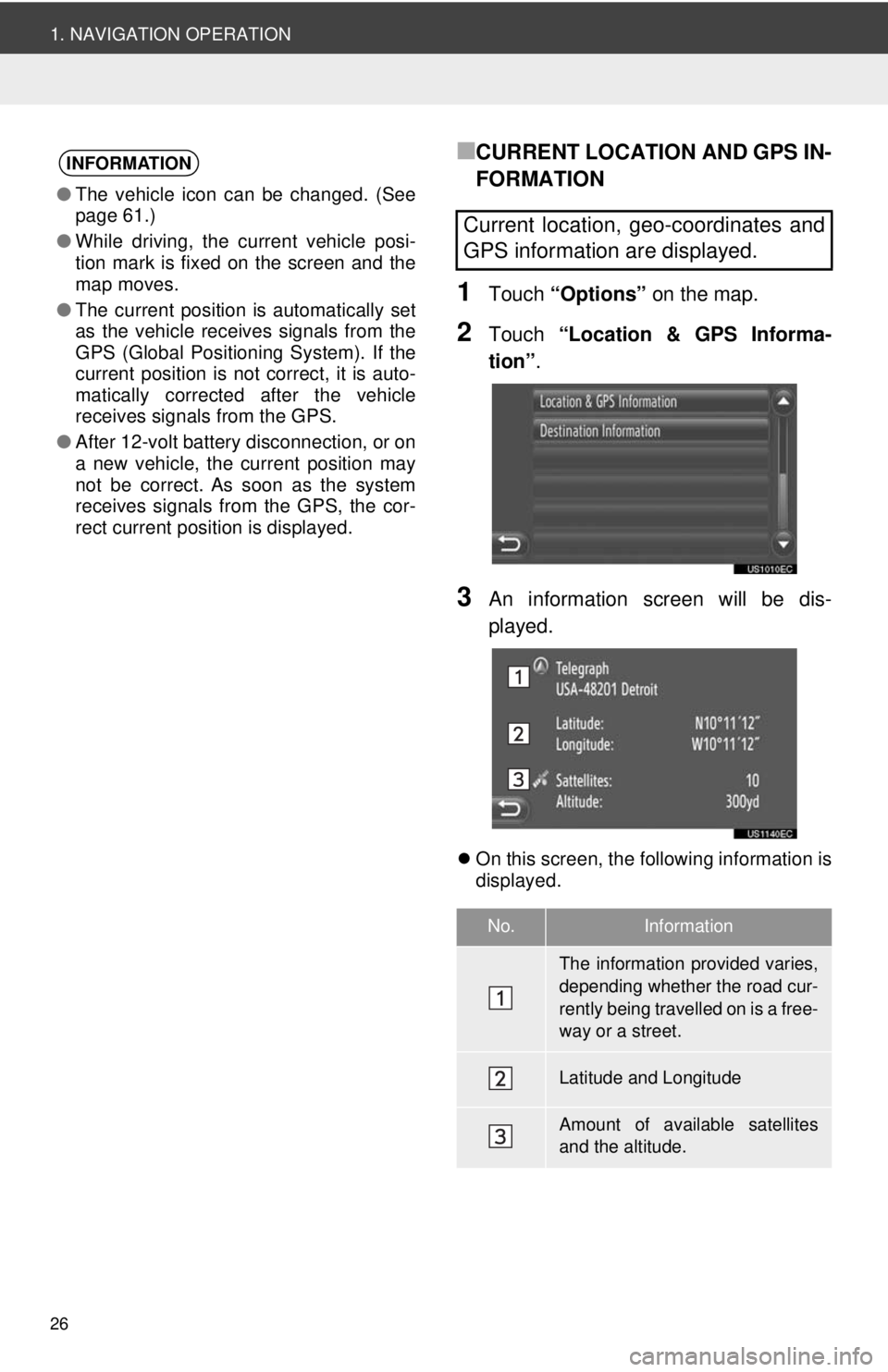
1Touch “Options” on the map.
2Touch “Location & GPS Informa-
tion” .
3An information screen will be dis-
played.
On this screen, the following information is
displayed.
INFORMATION
●The vehicle icon can be changed. (See
page 61.)
● While driving, the current vehicle posi-
tion mark is fixed on the screen and the
map moves.
● The current position is automatically set
as the vehicle receives signals from the
GPS (Global Positioning System). If the
current position is not correct, it is auto-
matically corrected after the vehicle
receives signals from the GPS.
● After 12-volt battery disconnection, or on
a new vehicle, the current position may
not be correct. As soon as the system
receives signals from the GPS, the cor-
rect current position is displayed.
Current location, geo-coordinates and
GPS information are displayed.
No.Information
The information provided varies,
depending whether the road cur-
rently being travelled on is a free-
way or a street.
Latitude and Longitude
Amount of available satellites
and the altitude.
Page 27 of 228
27
1. NAVIGATION OPERATION
2
APPLICATION-“Map”
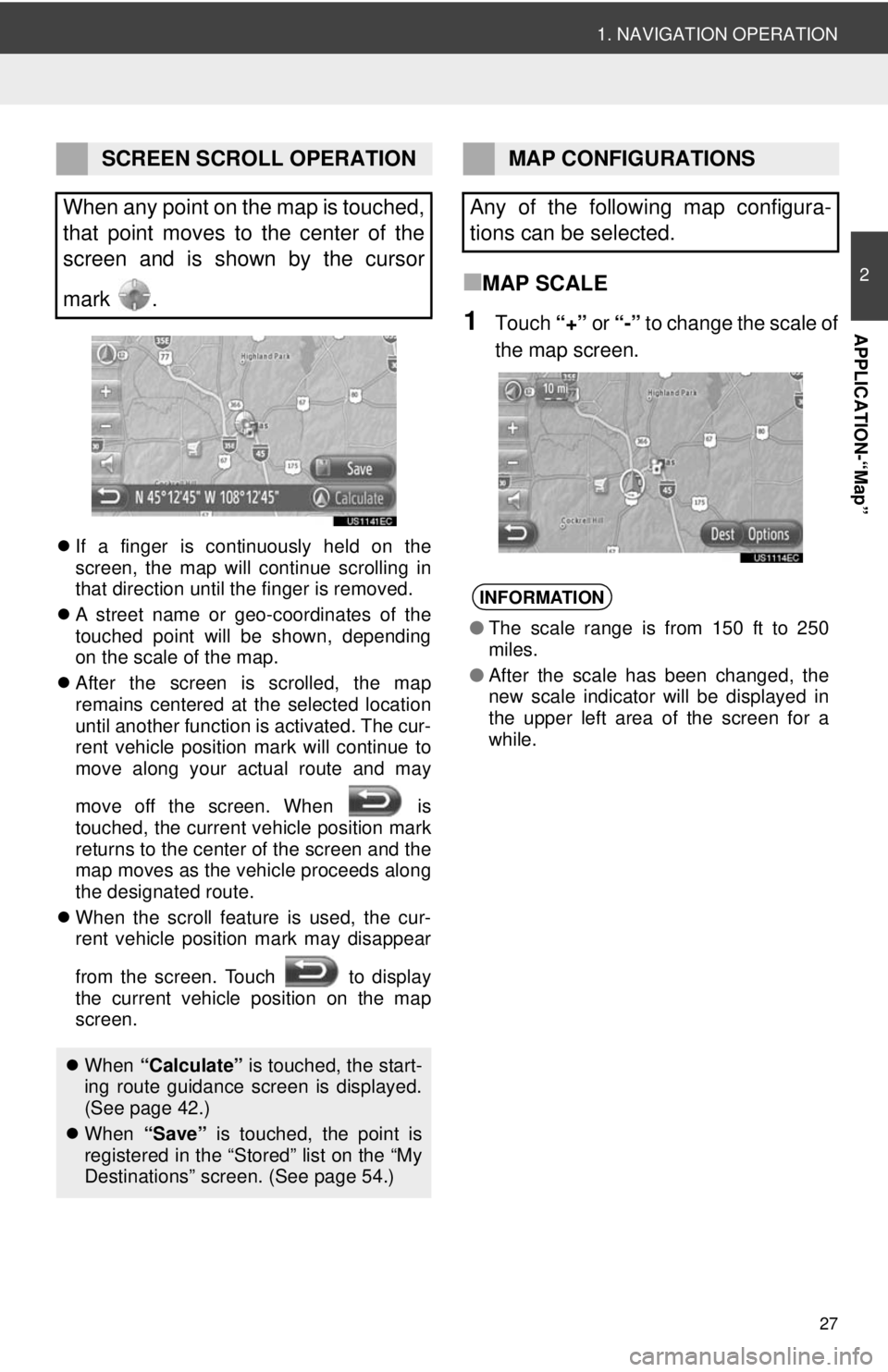
If a finger is continuously held on the
screen, the map will continue scrolling in
that direction until the finger is removed.
A street name or geo-coordinates of the
touched point will be shown, depending
on the scale of the map.
After the screen is scrolled, the map
remains centered at the selected location
until another function is activated. The cur-
rent vehicle position mark will continue to
move along your actual route and may
move off the screen. When is
touched, the current vehicle position mark
returns to the center of the screen and the
map moves as the vehicle proceeds along
the designated route.
When the scroll feature is used, the cur-
rent vehicle position mark may disappear
from the screen. Touch to display
the current vehicle position on the map
screen.
■MAP SCALE
1Touch “+” or “-” to change the scale of
the map screen.
SCREEN SCROLL OPERATION
When any point on the map is touched,
that point moves to the center of the
screen and is shown by the cursor
mark .
When “Calculate” is touched, the start-
ing route guidance screen is displayed.
(See page 42.)
When “Save” is touched, the point is
registered in the “Stored” list on the “My
Destinations” screen. (See page 54.)
MAP CONFIGURATIONS
Any of the following map configura-
tions can be selected.
INFORMATION
● The scale range is from 150 ft to 250
miles.
● After the scale has been changed, the
new scale indicator will be displayed in
the upper left area of the screen for a
while.
Page 28 of 228
28
1. NAVIGATION OPERATION
■MAP LAYOUT
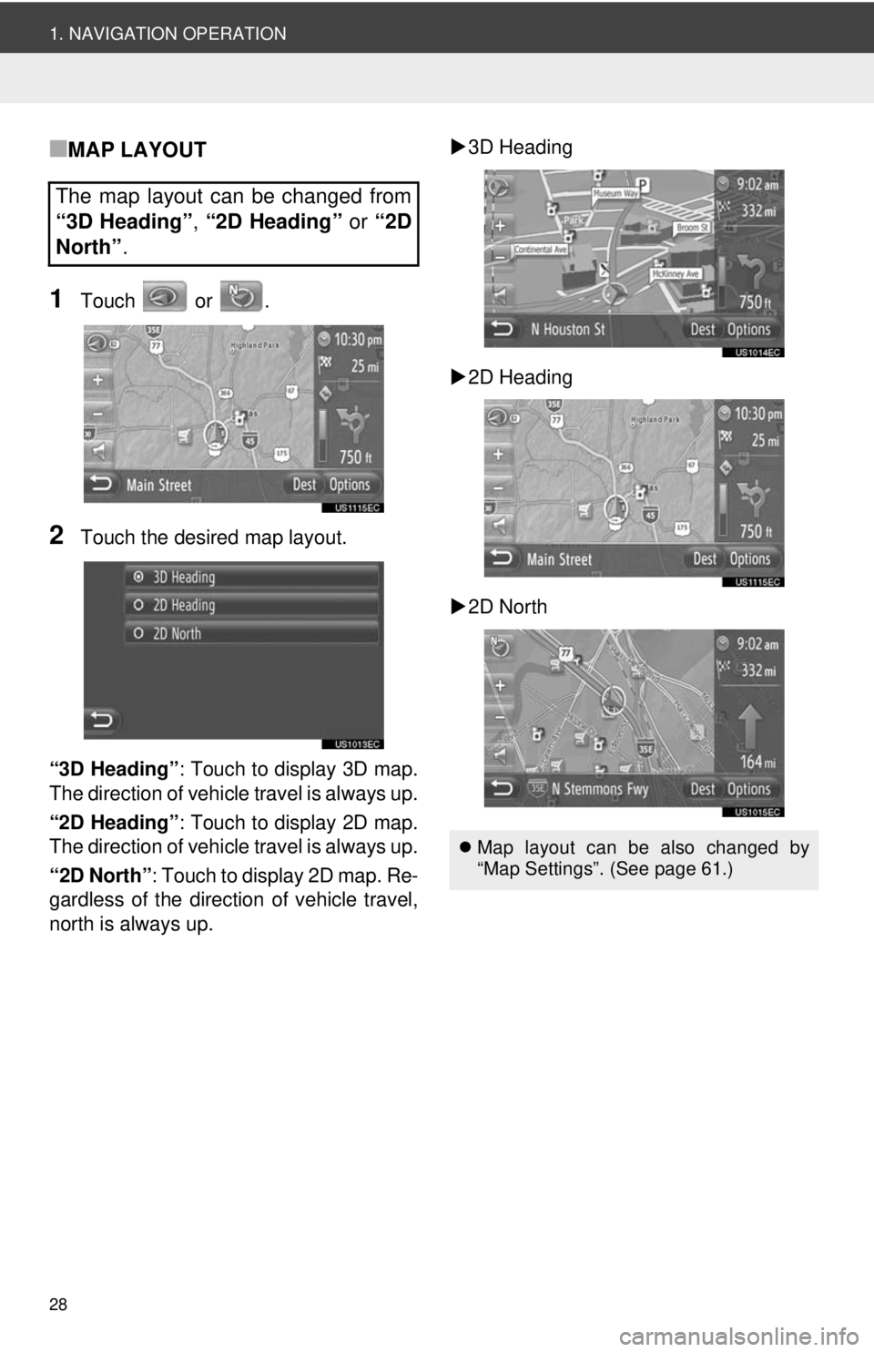
1Touch or .
2Touch the desired map layout.
“3D Heading” : Touch to display 3D map.
The direction of vehicle travel is always up.
“2D Heading” : Touch to display 2D map.
The direction of vehicle travel is always up.
“2D North” : Touch to display 2D map. Re-
gardless of the direction of vehicle travel,
north is always up.
3D Heading
2D Heading
2D North
The map layout can be changed from
“3D Heading” , “2D Heading” or “2D
North” .
Map layout can be also changed by
“Map Settings”. (See page 61.)
Page 29 of 228
29
2
APPLICATION-“Map”
1. NAVIGATION OPERATION
4. MAP ICONS
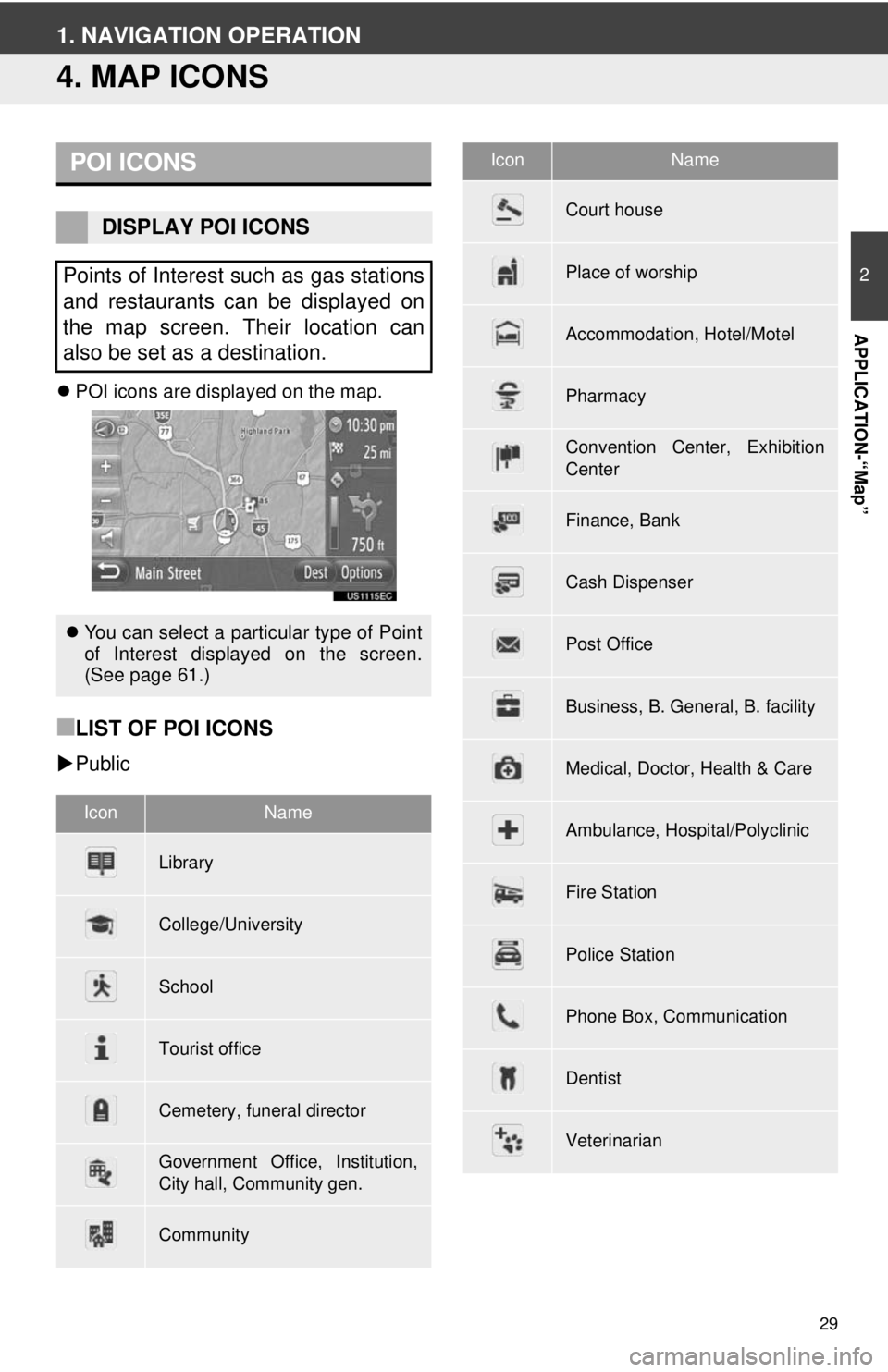
POI icons are displayed on the map.
■LIST OF POI ICONS
Public
POI ICONS
DISPLAY POI ICONS
Points of Interest such as gas stations
and restaurants can be displayed on
the map screen. Their location can
also be set as a destination.
You can select a particular type of Point
of Interest displayed on the screen.
(See page 61.)
IconName
Library
College/University
School
Tourist office
Cemetery, funeral director
Government Office, Institution,
City hall, Community gen.
Community
Court house
Place of worship
Accommodation, Hotel/Motel
Pharmacy
Convention Center, Exhibition
Center
Finance, Bank
Cash Dispenser
Post Office
Business, B. General, B. facility
Medical, Doctor, Health & Care
Ambulance, Hospital/Polyclinic
Fire Station
Police Station
Phone Box, Communication
Dentist
Veterinarian
IconName
Page 30 of 228
30
1. NAVIGATION OPERATION
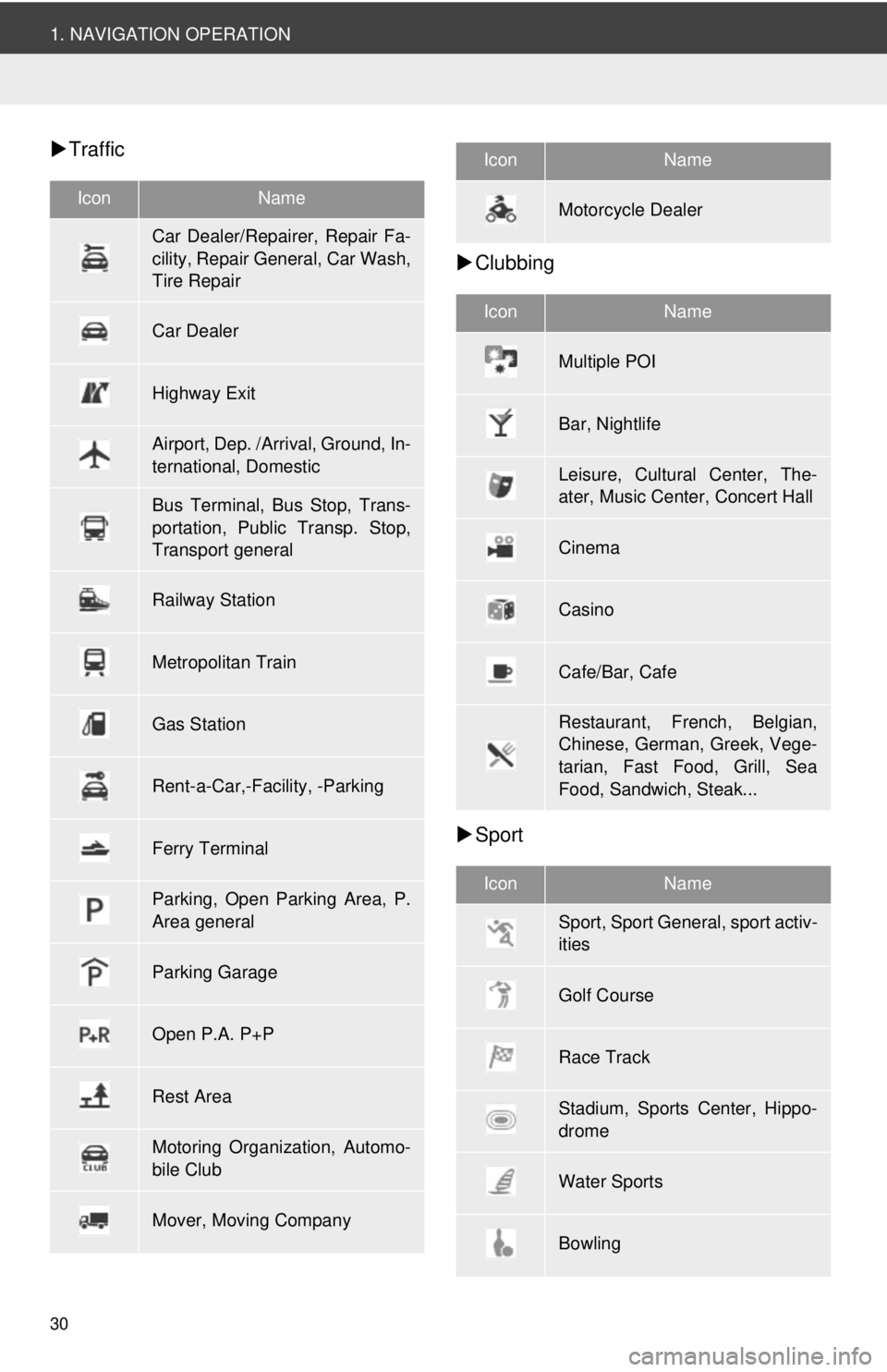
Traffic
Clubbing
Sport
IconName
Car Dealer/Repairer, Repair Fa-
cility, Repair General, Car Wash,
Tire Repair
Car Dealer
Highway Exit
Airport, Dep. /Arrival, Ground, In-
ternational, Domestic
Bus Terminal, Bus Stop, Trans-
portation, Public Transp. Stop,
Transport general
Railway Station
Metropolitan Train
Gas Station
Rent-a-Car,-Facility, -Parking
Ferry Terminal
Parking, Open Parking Area, P.
Area general
Parking Garage
Open P.A. P+P
Rest Area
Motoring Organization, Automo-
bile Club
Mover, Moving Company
Motorcycle Dealer
IconName
Multiple POI
Bar, Nightlife
Leisure, Cultural Center, The-
ater, Music Center, Concert Hall
Cinema
Casino
Cafe/Bar, Cafe
Restaurant, French, Belgian,
Chinese, German, Greek, Vege-
tarian, Fast Food, Grill, Sea
Food, Sandwich, Steak...
IconName
Sport, Sport General, sport activ-
ities
Golf Course
Race Track
Stadium, Sports Center, Hippo-
drome
Water Sports
Bowling
IconName